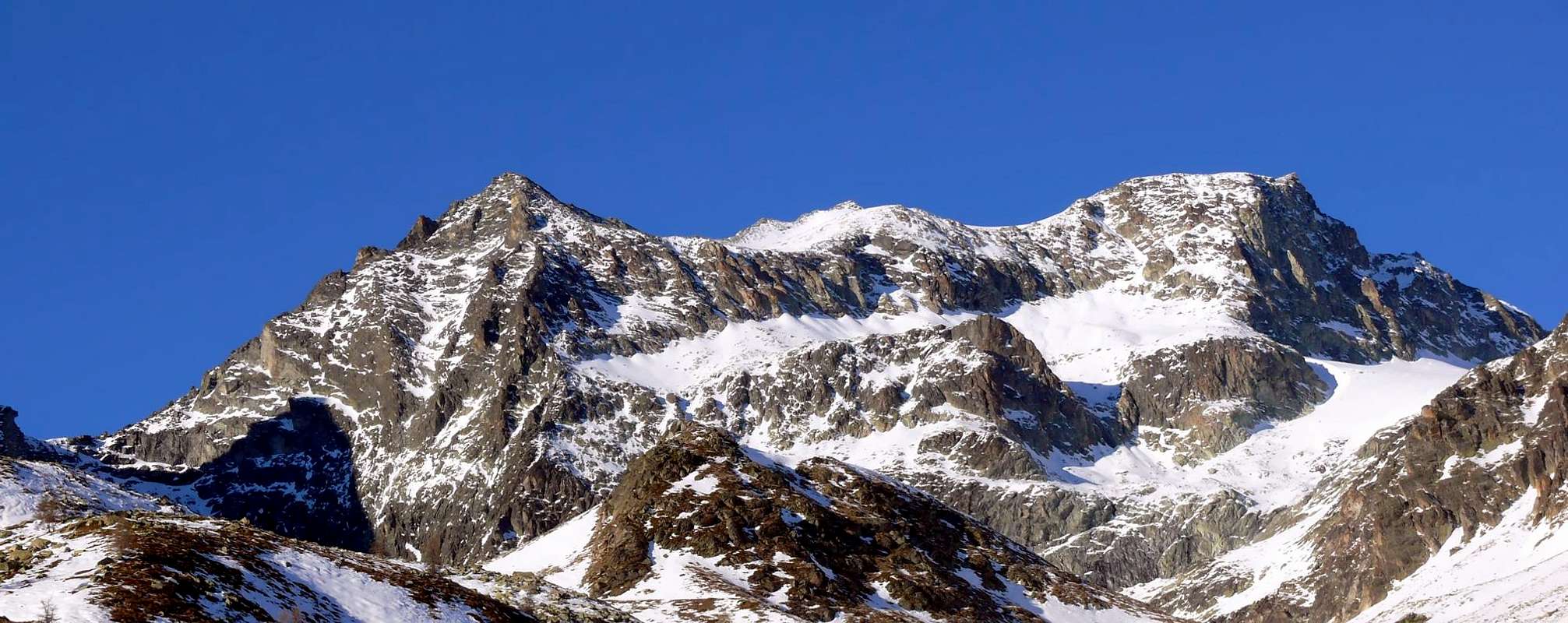
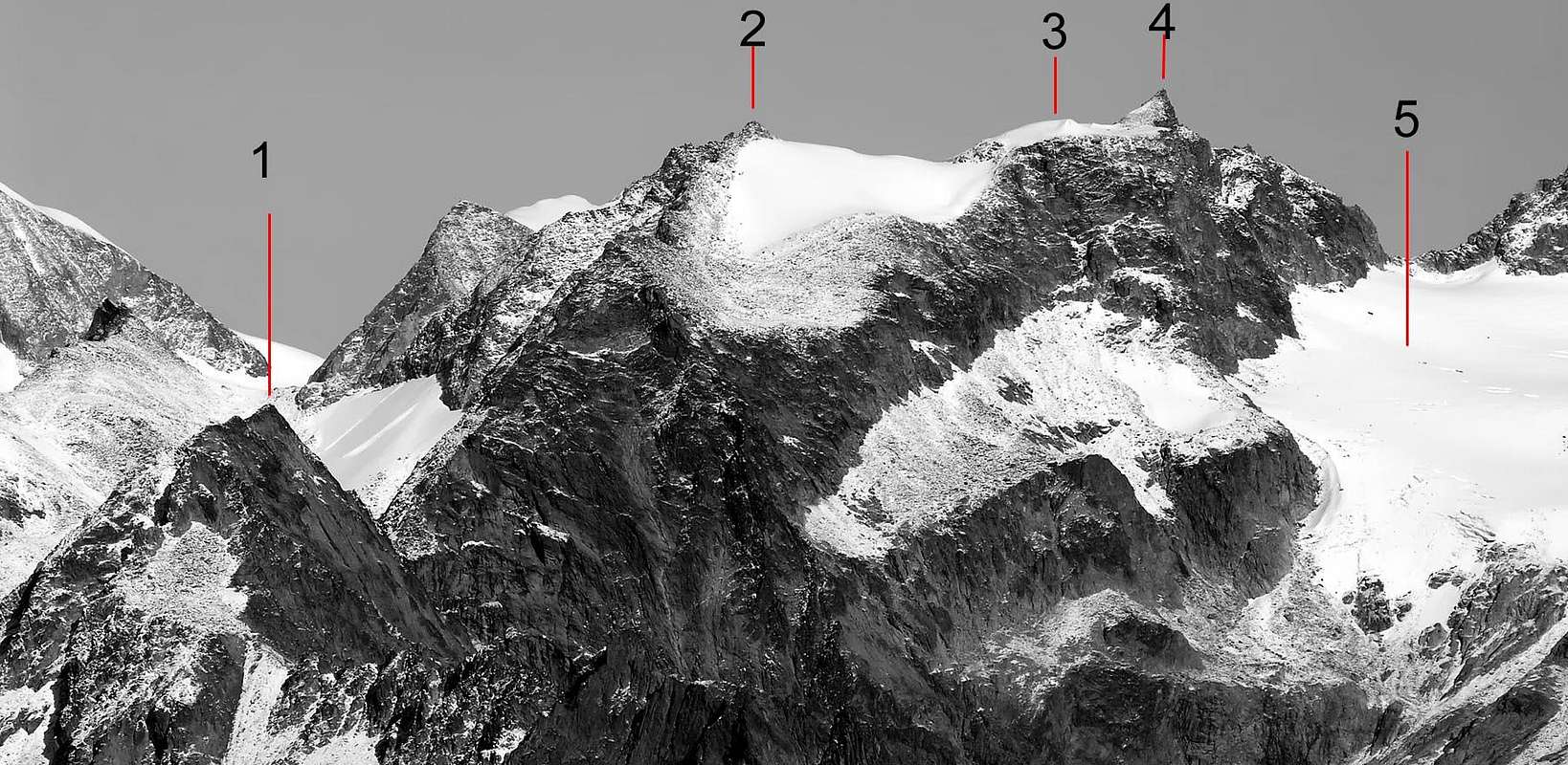
Big mountain made of 3 summits; two of them are, on the border between Switzerland and Italy, between the Passes of Chardoney (3.186m) and of la Rayette (3.319m); the third one (aka Becca di Chardoney Inferiore aka Pic de Chardoney (3.284m), above the Col Berlon (3.009m). This summit is at the crux of 4 glaciers (Epicoun, du Col, Haut e Bas du Chardoney), and gives a great view on the gran Glacier d'Otemma.
Montagna massiccia comprendente tre vette: due sul confine italo-elvetico tra i Colli di Chardoney (3.186 m) e il Colle de la Rayette (3.319 m); la terza soprastante il Col Berlon (3.009 m) o Becca di Chardoney Inferiore, conosciuta anche con il nome di Pic de Chardoney (3.284 m). Sita a cavallo di quattro ghiacciai (Epicoun, du Col, Haut e Bas du Chardoney), presenta una formidabile vista sul grandioso Glacier d'Otemma.
First Ascent
Becca di Chardoney:
First on the summit: Arthur Cust and Xaver Andermatten, (Aug 22th, 1882).
In winter: Unknown.
W Couloir: Marcel Kurz and Cyrille Favre, (Oct 17th, 1922), in descent.
N-E Arête: Marcel Kurz and Cyrille Favre, (Oct 17th, 1922).
N-W Arête: Ernst Jenny, Aloys Burgener and Emile Crettez (Jul 20th, 1921).
Pic de Chardoney:
First on the summit: Unknown.
In winter: Unknown.
S-Arête: Giovanni and Luciana Rossi, (Jul 19th, 1970).
SW Arête: Giovanni and Lucio Monaco, (Sep 28th, 1964).
SW Arête (integral): Osvaldo Cardellina, Luigi Gadin and Eusèbe Imperial, (Aug 03th, 1986).
Getting There
BY CAR:
From Torino, Milano, etc: Motorway A5. Exit at Aosta Est.
From Switzerland: through the Grand Saint Bernard Tunnel or the namesake pass.
From France: through the Mont Blanc Tunnel or Petit Saint Bernard Pass. It is not necessary to take Motorway A5: you can drive on SS.26, in the direction of Aosta.
BY PLANE:
Aeroporto "Corrado Gex" Saint Christophe (Aosta).
Itinerary
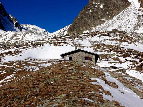
From highway toll of Aosta Est follow the SS.27 of Gran San Bernardo Tunnel, drive for about ten km and turn, to the right, toward Valpelline (964m), pass through it and follow for Oyace (1.377m). Once in Dzovenno (1.575m), turn to the left toward the small Village of Ruz (1.697m), park the car and start walking along a comfortable dirt road leading to the Baou de Bouque (2.129m) and to the Berrier Pastures (2.192m)(1h'30).
Dall'uscita del Casello Autostradale di Aosta Est, proseguire sulla SS.27 in direzione del tunnel del Gran San Bernardo; dopo circa un decina di chilometri svoltare sulla destra verso il Paese di Valpelline (964 m). Dopo averlo superato ed aver ignorato il bivio sulla sinistra che conduce a Ollomont (1.335 m), proseguire verso l'Abitato di Oyace (1.377 m). Raggiunta la Frazione di Dzovenno (1.575 m), svoltare a sinistra verso il piccolo Villaggio di Ruz (1.697 m); qui posteggiare l'auto e iniziare la salita a piedi lungo la comoda strada poderale che conduce all'Alpeggio Baou de Bouque (2.129 m). Dopo averlo oltrepassato, si raggiunge poco dopo l'Alpeggio di Berrier (2.192 m), (1h'30).
Route
From Alpe Berrier (2.192m) start walking along the path East of the Vertsan Stream and go on up to the Alpeggio di Chardoney (2.520m) passing through a wide grassy plain (about 500m) with many springs. Walk up along the Vertsan Basin toward the snow fields of Chardoney Inferiore; and clumber along the "grande muraglia" (big wall) of debris and huge stones of the Col Berlon (3.009m). Climb along the SW ridge of the Chardoney Inferiore turning to NW some slabs and, staying low under the edge, passing to SE a steep ledge, then along the edge get the summit (3.284m). Along an easy slope (normally in snow) up to the West Summit (3.407m) then to the East one (3.447m).(5h'00/6h'00).
Descent: Back slightly to the West and scramble down to the South (tricky) till a narrow and steep snow channel descending to the Bas Glaciers, down toward SW where it becomes steeper (danger for falling stones), then directly down to the Vertsan Basin.
Dall'Alpe Berrier (2.192 m) prendere il sentiero a est del Torrente Vertsan; risalirlo sino all'Alpeggio di Chardoney (2.520 m), dopo aver superato un ripiano erboso di circa 500 metri con molte sorgenti. Percorrere la Comba di Vertsan puntando decisamente verso la Chardoney Inferiore in direzione di nevati; inerpicarsi lungo la "grande muraglia" di detriti e ciclopici macigni del Col Berlon (3.009 m). Risalire la cresta SW della Chardoney Inferiore, aggirando a NW alcune placche su blocchi; superare un ripido risalto a SE continuando sotto cresta; poi sempre sul filo raggiungerne la cima (3.284 m). Proseguire su un facile pendio (quasi sempre nevoso) fino alla Punta Ovest (3.407 m) ed infine alla Punta Est (3.447 m).(5h'00/6h'00).
Discesa: Ritornare leggermente a W e scendere a S per roccette (delicato), che portano ad un canalino nevoso, stretto e ripido che da sul Bas Glaciers; percorrerlo verso SW dove diventa ripido (pericolo cadute pietre), scendendo poi direttamente alla alla Comba di Vertsan.
FONDAZIONE MONTAGNA SICURA Villa Cameron, località Villard de la Palud n° 1 Courmayeur (AO) Tel: 39 0165 897602 - Fax: 39 0165 897647.
SOCIETA' DELLE GUIDE DELLA VALPELLINE Etroubles-Strada Nazionale, n° 13 - Tel +39 0165 78559 - Valpelline-Loc Capoluogo, n° 1 - Tel +39 0165 713502 (AO) Italia.
A.I.NE.VA. (Associazione Interregionale Neve e Valanghe).
Useful numbers
Protezione Civile Valdostana località Aeroporto n° 7/A Saint Christophe (Ao) Tel. 0165-238222.
Bollettino Meteo (weather info) Tel. 0165-44113.
Unità Operativa di Soccorso Sanitario Tel. 118.
Acknowledgements
I am greatly indebted to my friend "Osva" for the detailed description of the route. In addition i want to thank Gabriele Roth for the translation of the text from italian.
Parents refers to a larger category under which an object falls. For example, theAconcagua mountain page has the 'Aconcagua Group' and the 'Seven Summits' asparents and is a parent itself to many routes, photos, and Trip Reports.

 8902 Hits
 90.81% Score
 33 Votes