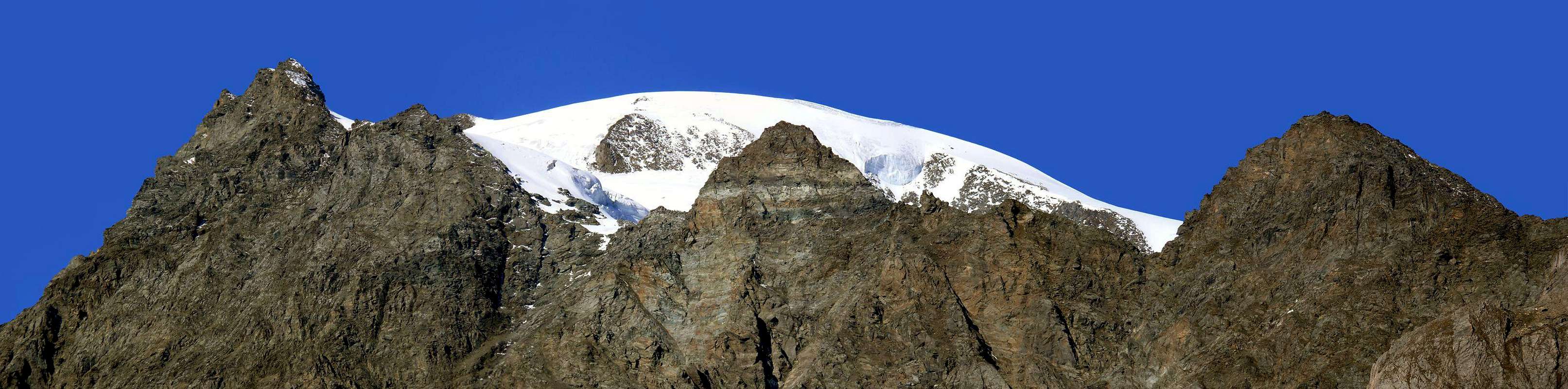
The Mont Velan, powerful mountain before the series of majestic Combins, comes down with a ridge dividing the Italian/Swiss first towards Southeast in the direction of the Horns of Velan and then to the Northeast until Valsorey Pass (3.107m); in this last and longest stretch well shape gradually, after the Horns, Denti (Jags) of Velan, the Tête (Head) of Ariondet, Mont Capucin, Doigt (Finger) du Mont Velan and Cordine. All these summits are rarely climbs and longer constitute the point of arrival for climbing on the great East-southeast Wall of Velan addressed to the City of Aosta (besides these very rare) that does not aim to reach as an end in itself. Only the Mont Cordine is reached and crossed (but not always, because you prefer to descend through its Northern Slope Glacier Valsorey just before reaching it) to connect with the normal route to the Mont Velan which goes along the same glacier from the Hut Velan entirely on Swiss territory. Another variant allows the other hand, after crossing the Summit, to get down on the same through a small rocky rib, but it turned to the North; just after the crest down to the Chamois Pass (3.259m) and to a characteristic rocky spire called Doigt du Velan (3.314m). From The Summit in South beautiful views on the By Basin and to the Town of Aosta, on the Grand Golliaz in the Southwest but, above all, dramatic panoramic view of the Grand Combin de Grafeneire that rises immediately to the North by the Himalayan lines.
Il Mont Velan, potente montagna che precede la serie dei maestosi Combins, scende con una cresta di confine italo/svizzera dapprima verso Sudest in direzione dei Corni del Velan ed in seguito verso Nordest fino al Colle di Valsorey (3.107 m); in questo ultimo e ben più lungo tratto forma progressivamente, dopo i Corni, i Denti del Velan, la Tête d'Ariondet, il Mont Capucin, il Doigt du Velan ed il Mont Cordine. Tutte queste sommità son raramente salite e costituiscono più punto di arrivo per le scalate sulla grande Parete Est-Sudest del Velan, rivolta alla Città di Aosta (per altro anche queste veramente assai rare), che non meta da raggiungere come fine a se stessa. Solo il Mont Cordine viene raggiunto ed attraversato (ma non sempre, poiché si preferisce scendere tramite il suo Versante Settentrionale sul Ghiacciaio di Valsorey appena prima di raggiungerlo) per collegarsi alla Via Normale per il Mont Velan che sale, lungo il medesimo ghiacciaio, dalla Capanna del Velan completamente in territorio svizzero. Un'altra variante consente invece, dopo aver attraversato la Cima, di scendere sopra il medesimo tramite una piccola costola rocciosa, anche essa rivolta a Settentrione; subito dopo la cresta scende al Col des Chamois (3.259 m) ed ad un caratteristico ago roccioso chiamato Doigt du Velan (3.314 m). Dalla Sommità belle vedute sulla Conca di By a Sud fino alla Città di Aosta, sul Grand Golliaz a Sudovest ma, e soprattutto, clamoroso panorama sul Grand Combin de Grafeneire innalzalzantesi subito a Nord con linee Himalayane.
First Ascents
First on the summit: Unknown.
In winter: Unknown.
South Wall: Giovanni Soncelli and Paride Tagliabue, Aug 17th, 1939.
Getting There
BY CAR:
From Torino, Milano, etc: Motorway A5. Exit at Aosta Est.
From Switzerland: through the Grand Saint Bernard Tunnel or the namesake pass.
From France: through the Mont Blanc Tunnel or Petit Saint Bernard Pass. It is not necessary to take Motorway A5: you can drive on SS.26, in the direction of Aosta.
BY PLANE:
Aeroporto "Corrado Gex" Saint Christophe (Aosta).
Itinerary and Approach
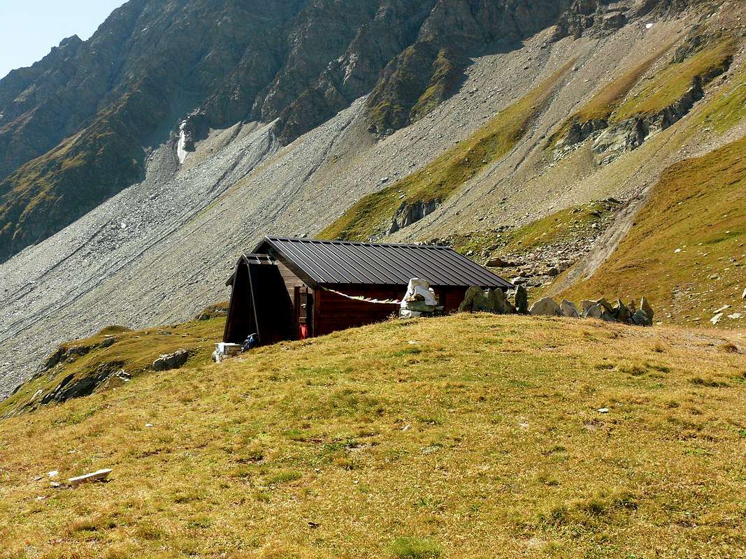
From Aosta East exit of the motorway, follow along the SS.27 for the Gran San Bernardo Tunnel After about ten Km turn to the right toward Valpelline (964m), cross it and turn to the left to get Ollomont (1.335m) and the small built area of Glacier (1.549m), where you must start walking. From the Glacier (1.549m) to climb the steep route that leads to the alpine pasture Porchère (2.094m) and the Tsa of superior Porchère (2.280m); to follow a small valley to when becomes a very steep. To continue then northwest towards a grassy back to result northeast towards the Bivouac Savoye-Rosaire (2.674m3h'00).
Dall'uscita del Casello Autostradale di Aosta Est, proseguire sulla SS.27 in direzione del tunnel del Gran San Bernardo; dopo circa un decina di chilometri svoltare sulla destra verso il Paese di Valpelline (964 m). Dopo averlo superato svoltare sulla sinistra e raggiungere il Paese di Ollomont (1.335 m); proseguire sino alla Frazione di Glacier (1.549 m), dove inizia l'itinerario a piedi. Da Glacier salire il ripido sentiero che conduce all'Alpe Porchère (2.094 m) e il superiore Tsa di Porchère (2.280 m); seguire un piccolo vallone sino a quando diviene molto ripido. Proseguire a nord-ovest verso un dosso erboso per poi voltare a nord-est verso il Bivacco Savoie-Rosaire (2.674 m3h'00).
Route
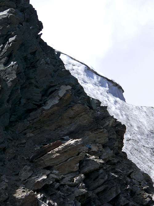
From the Bivacco out Rosazza/Savoye and from the neighbor of Boegno Bas Pass (2.674m) to address him toward Northeast along a trace that with a long diagonal in "light" ascent, overcoming some small valleys in grass and debris, it brings him in direction of a small torrent that comes out of an area of large boulders in the midst of which you have to find the traces of the passage; exceeded the same, leave the bottom of the valley and climb to the left (West) up the steep scree slope that leads to the Valsorey Pass (3.107m), located between the Mont Cordine and Tre Fratelli (Three Brothers). On a track, which often disappears, go up in the direction of achieving the same end of a broken route and debris immediately to his left; overcome it, taking care not to drop the stones on those who follow. Once up the hill to the right cross in the same direction, passing some small balconies with easy but exposed rocks; the frame of the hill, in general, it always passes to the left against the start of the Northeast Ridge Cordine. From the pass you do not continue with this, but, leaning to the right on a clear track, climb through the shattered Northeast Slope; progressively move, always following the trail on the ridge, reaching a shoulder snow at an altitude of 3.221 meters, called "Plateau de Cordine". Leaving on a rocky spur that goes right up to plunge into the glacier through broken rocks and debris, but easily reach the Top (3.329m; A.; F+/PD-; 2h'15/2h'30).
DESCENT: From the same route.
Dal Bivacco Rosazza/Savoye e dal vicino Col du Boegno Bas (2.674 m) indirizzarsi verso NW lungo una traccia che con un lungo diagonale in leggera salita, superando alcuni valloncelli in erba e detriti, si porta in direzione di un torrentello fuoriuscente da una zona di grandi massi in mezzo ai quali bisogna trovar le tracce di passaggio; oltrepassati i medesimi, abbandonare il fondo del vallone e salire più verso sinistra (Ovest) il ripido pendio detritico che conduce verso il Colle di Valsorey (3.107 m), posto tra il Mont Cordine ed i Tre Fratelli. Su d'una traccia, che spesso tende a scomparire, salire in direzione del medesimo raggiungendo una fascia di rotte rotte e detritiche subito sulla sua sinistra; superarla facendo attenzione a non far cadere delle pietre sopra chi segue. Arrivati all'altezza del colle attraversare verso destra in direzione dello stesso passando alcuni piccoli balconi con rocce facili ma esposte; la cornice del colle, in genere, la si supera sempre a sinistra contro l'inizio della Cresta Nordest del Cordine. Dal colle non si continua tramite questa, bensì, appoggiando a destra su d'una evidente traccia, si sale per mezzo del frantumato Versante Nordest; progressivamente portarsi, sempre seguendo le tracce, sulla cresta raggiungendo una spalla innevata a quota 3.221 m, detta "Plateau de Cordine". Lasciando sulla destra uno sperone roccioso che scende fino ad immergersi nel ghiacciaio, tramite rocce rotte e detrito, ma con percorso facile, raggiungere la Cima (3.329 m; A;F+/PD-; 2h'15/2h'30).
DISCESA: Per la medesima via.
Difficulty
This route can be considered F+/PD-.
L'itinerario è classificato F+PD-.
Equipment
Standard mountaineering equipment.
Da alpinismo.
Huts
Bivacco ROSAZZA-SAVOIE (2.674m)
Campings
Remember that free camping is forbidden (except for emergency reasons, over 2.500m, from darkness until dawn).
Mountain Conditions
You can get meteo information at the official site of the Regione Valle d'Aosta:
Parents refers to a larger category under which an object falls. For example, theAconcagua mountain page has the 'Aconcagua Group' and the 'Seven Summits' asparents and is a parent itself to many routes, photos, and Trip Reports.

 5423 Hits
 87.76% Score
 25 Votes