
|
|
Mountain/Rock |
|---|---|
|
|
42.71927°N / 0.16685°E |
|
|
Hiking, Mountaineering, Mixed, Scrambling, Via Ferrata, Skiing |
|
|
Spring, Summer, Fall, Winter |
|
|
9094 ft / 2772 m |
|
|
Note : Let's save the Saux and Gela valleys !
This beautiful site is threatened by a project of extension of the ski-resort of Piau-Engaly... More information here, here, here.In the high Aure valley, the project of creating a ski resort on one of Piau Engaly threat to disfigure the two magnificent valleys of Saux and Gela.
These places are close to the French National Park as well as its Spanish neighbour of Monte Perdido (Unesco list), both hosting invaluable endemic flora and fauna, as well as pastoral areas of quality, sentenced in the short term with this project.
Global warming, energy conservation, Spanish economic crisis are forgotten by deciders, prepared to sacrifice these valleys, praised by sherperds, hikers and mountaineers.
The local population is indigned against this hypothetical investment. Let's join them to make sure that these irresponsible behaviors stop forever.
Please join the petition on the site www.sauvons-la-gela.org and make yourself an idea of irreversible damage to come.
Thank you.
 Muraille de Barroude
Overview
 Lacs de Barroude
 Port de Barroude
 Camino de las Pardas
 Camino de Las Pardas
 Glacier of Barroude
 Evening on Sierra de Liena
 Sunset on Monte Perdido
Pico de Barrosa, or Soum de Barroude in French, lies on the border, slightly excentred over the Spanish mountainside. The "peak" is relatively anonymous, and consists only in a long round-shaped promontory, a fine viewpoint, but nothing to compare with the other jagged surrounding tops.
Barroude/Barrosa, often mispelled (the double R is often forgotten and french tend to put the double S, since we say "SA"), is above all a duet of valleys that form an unique site in the Pyrenees, and the peak is only a pretext to visit them; Traverse eased by the proximity of the international tunnel.
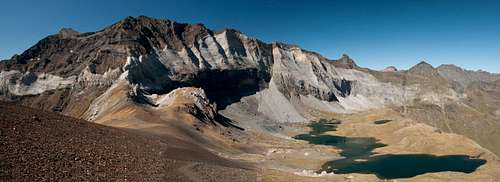
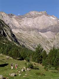
Barroude, reached shortly before the border, is a green pastoral valley which provides stunning views to what we usually call the "Barroude walls", which are not less than the other side of the "Troumouse walls" in the eponymous Cirque, equally impressive. Upper in this valley, a grassy balcony hosts a couple of beautiful lakes, the "Lacs de Barroude", just on the foot of the mentionned walls. From moraine origin, they belong to the restricted club of the lakes on limestone terrain, and are unique in the Pyrenees. A mountain hut standing nearby allows to enjoy the site overnight. A short ascent over them leads to Port de Barroude, or Puerto de Barrosa, the pass as it is called in both languages.
Barrosa, equally short to reach from the border, presents a different face. The pines and the blue water of the stream make the atmosphere much more "southern", with a marked foretaste of Spain, despite granite is surprisingly found on this terrain (they make the continuity of the granitic West slope of the Fulsa, before making place for the limestone). As we go higher, the imposing silhouette of La Munia appears, over the same Barroude walls we saw from the French side, reached shortly after a wide grassy "Circo".
But Barrosa owns also something quite rare in the Pyrenees: a Via Ferrata. Or let's talk rather about a mule path that was fitted in a geologic crack of the cliffs, one century ago, for mining purposes. Since then, many landslides have occured, making this route too exposed, which explains why it is now secured by a handrail (since 2004 and a renovation). This route is called "Camino de las Pardas", and links Puerto de Barrosa to the peak Liena (or "Ruego"). With an unguarded hut (Montarruego), this spot is reached either from the Barrosa valley than by car via a land rover track in the neighbouring Chisagües valley.
 Pic de Barroude & Barroude walls from Pic de Port Vieux Pic de Barroude & Barroude walls from Pic de Port Vieux |
Getting There
 La Munia from Circo de Barrosa
 Circo de Barrosa from La Munia
 Circo de Barrosa in winter
 Circo de Barrosa in winter
 Circo de Barrosa from the Hospital de Parzan
 Lakes in autum
1/ Accessing Vallée de Barroude
The Barroude trailhead is very discrete and is located in the upper side of Aragnouet, as we drive towards the tunnel to Spain. As we drive up, passing the photogenic church Chapelle des Templiers below and leave the Piau-Engaly juction on the right, we reach at one point a set of 4 steep laces. The trailhead is located in the bend of the first turn, west. A tiny car park allows parking there a dozen of cars, more or less wildly...
2/ Accessing Circo de Barrosa
The Barrossa trailhead is facing the very first valley we see after exiting the tunnel (or very last if we drive to it), on the western mountainside, near the Hospital de Parzán (1400m), higher than the Parzán petrol station. A car park allows leaving the car here as well.
This valley shouldn't mixed with the Chisagües valley, next below, in which a land-rover track in bad state leads to the pass of Espluca Ruego, south end of the Via Ferrata.
View Larger Map
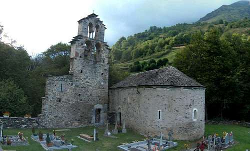 Chapelle des Templiers in upper Aragnouet
Routes
 Vallée de la Géla
 Vallée de la Géla
 Vallée de la Géla
 Vallée de la Géla
 Lacs de Barroude
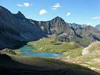 Lacs de Barroude
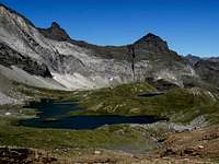 Lacs de Barroude
 Barroude walls
 Barrosa walls & Munia
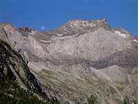 Barrosa walls & Munia
 Port de Barroude
 Port Vieux
 H. de Chermentas from val. Badet
 H. de Chermentas from Port Vieux
 Camino de Las Pardas
 Camino de Las Pardas
 Las Pardas, Barrosa end
 Las Pardas, Barrosa end
 Las Pardas, Liena end
 Las Pardas, Liena end
1/ Cirque de Barroude
As we start walking into the Barroude valley, we overlook on the left shore for a while a steep gorge in which flows a wild stream, the Neste de la Géla, with waterfalls. Without any views ahead yet.
The Cirque Barroude appeard suddenly only a couple of kilometers higher, as we leave the forest and the trail reaches a steady height near 1700m. The area is often populated with cattle, and the river, spreads in meanders.
The Barroude walls are already visible upper right (in the early sunshine, they can be very bright with the morning light coming east, while the Cirque is still in the shaddow).
In the very beginning of the Cirque, a ladder allows going on the right side of the stream. This is the trail going to the lakes. Keeping on the same side of the river leads to the other side of the cirque, to Pass Port-Vieux, often used as a descent route.
So, passing the ladder, we reach the west side of the cirque where the trail elevates on the grassy slope, with a lace in the middle, and a small exposed part on brittle stones.
The mountain hut appears, then the first lake, then the second. Over the lake, we reach the pass Port de Barroude shortly after. The wide broad ridge, made of schist debris, leads to "Soum de Barroude", a bump on the left. Pico de Barrosa is its real summit, overlooking the Spanish side.
This trail is well described here (French), with photos here, and a peak overview here.
The descent can be made by leaving "Soum de Barroude" East on the ridge and following it. Then we reach another peaklet, Pic de Port-Vieux, and then the homonym pass, "Port-Vieux", which was, as it name suggests, a well-used route since long ago during the past, when the tunnel didn't exist. The exploration can be pushed until Pic de l'Aiguillette. Then, the descent uses the route previously mentionned that reaches the ladder.
Many other combinations are also possible, including a very interesting possibility of linking the Vallon de Badet (Valley of Piau, described in the routes of Pic des Aiguillous to the Barroude valley via the saddle "Hourquette de Chermentas". A spectacular trail overlooking the void, and overlooked by the North end of the Barroude walls.
 Pic de l'Aiguillette Pic de l'Aiguillette |
2/ Circo de Barrosa
From the Hospital de Parzán, we head into the Circo de Barrosa, where a good path, elevating steadily along the beautiful stream, in a forest of pines. The subalpine area, divided by a granitic dome, is reached, then Puerto de Barrosa (2534m).
From this spot, we can either continue by one of the french routes, or make the traverse by the spectacular "path of the mines", called locally "Camino de las Pardas" (Mules path). This path is abundantly described, but in French only, on the excellent website of Pierre Carrière. See the pages about Chemin des Mines, Peak Liena, useful maps, a trip report. Camino de las Pardas can be reached from several alternative spots described here as well.
Until 2004, only the south half was featured with fixed chains, and it is now complete. In 2006 a landslide took away a part of the south half, but it was rebuilt again as well.
The Via Ferrata ends South on the Pass of Espluca Ruego (2493m). From there, a trail reaches the pass of Liena (2548m) and goes down to the mines of Liena.
From there, we need to find the old "mines path", little visible (it is located between the ridge and the cable still present with its shovels). Follow it carefully and do not lose it. Stay aware that it doesn't go down directly into the valley but follow the ridge, providing outstanding views. In some places it is quite invaded by wild vegetation. It finally ends few minutes away from the Hospital de Parzán.
Espluca Ruego is also reached by car (or on foot) via the track of the Chisagües valley. See an overview of the area to have a more complete inventory of all possible trails in the area. Some of them allow bagging La Munia, the Robiñera, the Pic de Troumouse and many other major three-thousanders of the area.
 Lac de Badet in Vallon de Badet Lac de Badet in Vallon de Badet |
Sleeping

 Montarruego Hut on the pass
 Montarruego Bivouac
 Refuge de Barroude
 Refuge de Barroude
 Refuge de Barroude
Guarded mountain huts :
Refuge de Barroude stands near the eponymous lakes on the French side.
Bivouacquing with a tent near this hut is allowed.
Unguarded mountain huts :
Refugio de Montarruego stands over the 2000m limit in the Sierra de Liena, on the south end of the Via Ferrata on the pass of Espluca Ruego, accessible by car via the (long) track of the Chisagües valley. 8 places, very basic, no furnitures. No water source nearby, wood to be found below involving a bit of walking. Bivouac with tents equally (not to say more) recommended.
Accomodations :
Aragnouet, on the French side, owns many accomodations due to its proximity with the Piau Engaly ski resort; look into the french section titled "Dans le Village".
Parzán, on the Spanish side, hasn't got so many accomodations, but one can find a couple of "Casas rurales" here
 East view from Pic de l'Aiguillette East view from Pic de l'Aiguillette |