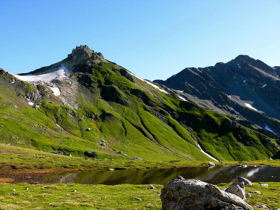
This small summit is located on the crest of the Swiss-Italian border and more precisely between the Fenêtre de Ferret (2.698m; to the West) and the Col de Fonteinte in opposite and even known as the Fenêtre-d'en-Haut (2.772m), the latter immediately behind the most important and massive Pointe du Drône (2.949m). Consists of two Summit, the highest of which, although only of two meters, is located about 250 meters further to the North and then completely on Swiss territory above the three small but beautiful Lacs de Fenêtre. Both, however, they are formed by rocks whitish or reddish very broken and debris that, in order to do a little research, offering a fun climbing on small West-southwestern Crest. As regards the name seems that derives from "fontaine teinte", or colored fountain with this factor due to a ferruginous water, while just below the Summit are the remains of an oven for the lime, used in ancient times by the Monks of the nearby Hospice of the Great St. Bernard. Beautiful glances to the South over this last and homonym valley and the distant Graian and towards the Gran Paradiso, while in the West the view can stretch on the nearby imponent Grand Golliaz (3.237m) above the Vallon of Ban Darrey then wander to the North on entire Swiss Val Ferret.
Questa piccola Sommità é situate sulla cresta di confine italo-svizzera e più esattamente tra la Fenêtre de Ferret (2.698 m; ad Ovest) ed il Col de Fonteinte conosciuto pure come Fenêtre-d'en-Haut (2.772 m), questo ultimo subito a ridosso della più importante e massiccia Pointe du Drône (2.949 m). Costituita da due Cime, la più elevata delle quali, anche se di soli due metri, si trova 250 metri circa maggiormente a Settentrione e quindi completamente in territorio svizzero al di sopra dei tre tanto piccoli quanto splendidi Lacs de Fenetre. Entrambe comunque sono formate da rocce biancastre o rossicce molto rotte e detriti che, volendo effettuare una piccola ricerca, offrono una divertente arrampicata sulla Crestina Ovest-sudovest. Per quanto concerne il toponimo sembra che derivi da "fontaine teinte", ovvero fontana colorata con questo fattore dovuto ad un acqua ferruginosa, mentre appena sotto la Sommità si notano i resti di un forno per la calce, utilizzato nei tempi antichi dai Monaci del vicino Ospizio del Gran San Bernardo. Ottimo panorama a Meridione sopra quest'ultima nonché omonima valle e sulle Alpi Graie da Sudest fino a Sudovest compreso il Massiccio del Gran Paradiso, mentre ad Occidente la vista può allungarsi sul vicino ed imponente Grand Golliaz (3.237 m) sopra il Vallone del Ban Darrey per poi spaziare a Settentrione verso l'intera Val Ferret svizzera.
From Torino, Milano, etc: Motorway A5. Exit Aosta Est.
From Switzerland: through the Grand St. Bernard Tunnel or the homonym pass.
From France: through Mont Blanc Tunnel or Petit St. Bernard Pass. It isn't necessary to enter in Motorway A5, you can drive through SS.26 Aosta direction.
BY PLANE:
Aeroporto "Corrado Gex" Saint Christophe (Aosta).
Approaches and Route
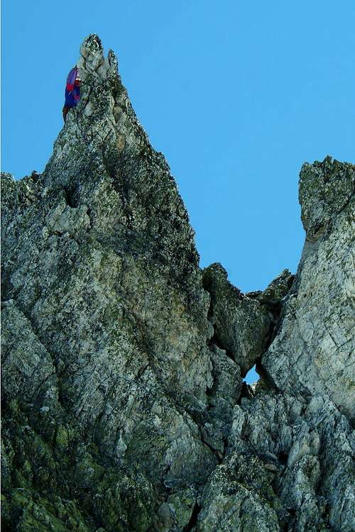
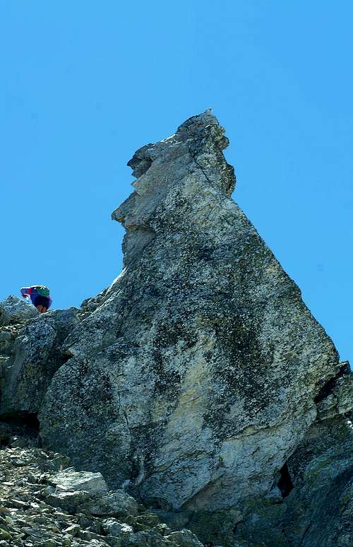
From Aosta (583m) drive along the Gran San Bernardo State Road (SS.n°27) and, after Gignod (988m), Etroubles (1.264m) and Saint Oyen (1.373m) Municipalities you must leave to your left the road to the Tunnel driving toward Saint Rhémy en Bosses along the valley ending to the pass. After many hairpins and passing Pra di Arc Pastures (1.992m), and the Cantina Reggia Dogana (2.203m) you get a small car parking near the Alpe Baou (2.356m) wherefrom starts the route to Italian Vallon Fenêtre through the Standard Via crossing the long valley. At the crossroads 2.557 meters with the small trail n° 13, abandoned left (West) the unnumbered path that rises along the entire valley and direct you instead to Northwest with the first. Reaching the Fenêtre de Ferret (2.698m). Follow the watershed border quickly through debris or sparce blocks and some small rocks, avoiding to the left (North) and just bottom the Western Crest (Variant: wanting to climb a little need to know that this is composed at the top or second part by rocks with quartzites with steps from II° to IV°), reaching the Southern Summit (2.772m) between the Fenêtre and Fenêtre-d'en-Haut Passes and from this easy crossing through a flat debris plateau or snowfield towards North reaching the Northern Vertex (2.774m), the highest. (E/F; 1h'30/2h'00 overall for the whole tour).
Dalla Città di Aosta (583 m) salire lungo la Strada Statale n°27 del Gran San Bernardo e, dopo aver superato i Comuni di Gignod (988 m), Etroubles (1.264 m), e Saint Oyen (1.373 m), lasciare sulla sinistra la strada che porta al Tunnel del Gran San Bernardo. Salire verso Saint Rhémy en Bosses (1.632 m) continuando lungo il vallone che porta al Colle e, dopo numerosi tornanti, si supera l'Alpeggio di Pra di Arc (1.992 m), la Cantina Reggia Dogana (2.203 m), e, raggiunto un piccolo parcheggio nei pressi dell'Alpe Baou (2.356 m), si inizia la salita nell'italiano Vallone di Fenêtre per la Via Normale snodantesi attraverso il lungo e vasto vallone fino a raggiungere Mont Fourchon e Pain de Sucre. Raggiunto il bivio 2.557 metri con il sentierino n° 13, abbandonare a sinistra (Ovest) quello non numerato che sale lungo tutto il vallone ed indirizzarsi invece a Nordovest con il primo, raggiungendo la larga e spaziosa Fenêtre de Ferret (2.698 m). Seguire lo spartiacque di frontiera formato da detriti, blocchi sparsi e rocce molto rotte di scarsa pendenza ed aggirando a sinistra (Settentrione) e subito sotto la Cresta Ovest (Variante: volendo divertirsi nonché arrampicare un pò bisogna prendere atto che questa risulta composta nella seconda parte, mentre la prima scende, dopo una larga sella camminabile, con direzione Sudovest verso il fondovalle, o superiore da rocce quarzitiche e spesso con fine lichene che offrono brevi passaggi, peraltro non obbligati, sul filo dal II° al IV° sui vari gendarmi e pinnacoli separati tra di loro da forcellette e piccoli intagli) pervenendo in breve tempo alla Sommità Meridionale (2.772 m) e da questa con facile traversata a Nord sul piatto plateau detritico o residui estivi di nevati il Vertice Settentrionale o Punta Nord (2.774 m), la più elevata. (E/F; 1h'30/2h'00 per l'intero tour).
Difficulty
F (easy) and for Hikers.
Facile e per Escursionisti.
Equipment
For Hiking.
Da Escursionismo.
Camping
Remember that free camping is forbidden (except for emergency reasons, over 2.500m, from darkness until dawn).
Mountain Conditions
You can get meteo information at the official site of the Regione Valle d'Aosta:
Parents refers to a larger category under which an object falls. For example, theAconcagua mountain page has the 'Aconcagua Group' and the 'Seven Summits' asparents and is a parent itself to many routes, photos, and Trip Reports.

 2242 Hits
 83.1% Score
 16 Votes