
|
|
Mountain/Rock |
|---|---|
|
|
49.21513°N / 19.75788°E |
|
|
Hiking, Mountaineering |
|
|
Spring, Summer, Fall, Winter |
|
|
6768 ft / 2063 m |
|
|
Overview
Wołowiec (slovak: Volovec, formerly "Hruby Vrch" or "Wolowec", the "beef's mountain"), is a peak in the Western Tatras with a height of 2064 meters, which makes the junction between 3 ridges:- On the East from Jarząbczy Wierch and Ńopata
- On the South from Ostrý Roháč and Placlivé
- On the north side by Rakoń and Grześ
 |
 |
 |
This one of the highest peaks in the Polish part of the Western Tatras and rises above the valleys: Chochołowska, Rohačká and Jamnická.
The height of the summit precisely measured already in 1820, and the summit itself was an important point triangulation. Previously, the slope of Wołowiec were grazing, and were a part of the Chochołowska meadow.
With a flat top, it offers very extensive and broad views. Janusz Chmielowski in 1898, wrote: "The summit Wołowiec is extremely interesting (...), in the south rises the jegged group of Rohacz (...), toward the east the High Tatras jut like a giant rocky island (...) On the north stand the dome of Babia Góra. On the west lie below the Rohackie Ponds."
The first ascent is unknown, since the mountain was probably known very long ago by sherperds, but the first winter entry to be recorded was in 1906, by the Hungarian mountainerr Mateja Bela with companions.
Let's mention that Wołowiec and the surrounding mountains (in the only exception of Ostrý Roháč), make excellent terrain in winter for ski-touring.
 |
 |
 |
Getting There
- Chochołowska starting point:
From Krakow, Poland: Drive in the direction of Zakopane until Rabka, then the road that goes through Chocholow. Park the car at the entrance of Dolina Chochołowska (guarded car park, around 10zl + entrance to the national park, from 7am). From Slovakia, cross to Poland at Sucha Hora.
- Rohačká Dolina starting point:
From Poland, cross to Slovakia at the road toll at Sucha Hora, to reach Oravice and Zuberec. From Slovakia, reach Zuberec via Zilina and Dolný Kubín.
- Jamnická or Žiarska Dolina starting points:
From Poland, very long way... from Krakow, prefer the border point at Chyżne. From Silesia, choose Korbielow or Rajcza/Novot. Reach Dolný Kubín and circumvent Tatras. From Slovakia, via Dolný Kubín and Liptovsky Mikulas.
- By public transports, all points mentioned above are reachable by bus: from Zakopane for Chochołowska, and from Liptovsky Mikulas for the others
Red Tape
The hiker must know that:- Offtrails is strictly forbidden in Polish Tatras.
- Offtrails in Slovakia is tolerated for mountain-climbing, when accompanied by a registered mountain guide, or holding a licence of UIAA club. But not all zones. Natura 2000 zones are strictly forbidden.
The west slope of Wołowiec, with the area of the lakes of Rohačká Dolina is such zone. Hence, the only place where such offtrail "might be" tolerated is Jamnická Dolina in the south.
Hence, in the conditions mentioned above (guided or card holder), the only point where offtrails would be of any interest is the little unoficial trail from Deravá Sedlo to Jamnické Pleso, allowing making a little loop. But be quick and do it in early morning ! :)
Border :
Since January 2008, both Poland and Slovakia belong to the Schengen european space, hence crossing the border is now allowed in almost all West Tatras (more precicely from June 15th 2008 which corresponds to the end of the slovak winter closure).
Let's mention anyway that Wołowiec was the only official border point (sharing this privilege with Rysy) allowed for hikers long ago before that.
But don't forget to always carry your papers in your rucksack if you plan to venture in the other country, even returning to the starting point.
Routes
There are thousands of routes to climb Wołowiec, since this mountain, as well as its surroundings, is served by dozens of trails. It would take ages to list all the possible circuits, loops, traverses... it is a "trail-hub".So here is a little summary with the most common circuits:
* Loop from the Polish side (Chochołowska valley):
The approach in this valley is very long ! In old maps, you might find the car park marked in Polana Hucinska, but to protect this valley, it was moved much further at the border of the park, in the 90's. For this reason, Dolina Chochołowska is probably the less freqented valley in Polish Tatras (also because the most distant from Zakopane...). You can shorten the approach by bike, with yours or with the bike rental at the entrance.
Note that there is also the very original solution to skate with rollers the asphalt part of the road (which covers almost all its lenght, until the old cabans), since the valley is very long with little elevation difference...
The circuit consists in climbing to Grześ and Rakoń by the yellow trail from the mountain-hut, then the summit, and descend via the green trail.
The loop is best made in this sense (anti-clockwise), since the sky is alway clearer in the morning.
The fittest ones can attempt the whole loop in the valley, via Kończysty Wierch.
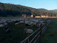
Don't forget to make a stop in Polana Chochołowska, just before the mountain-hut. These wooden huts are a very beautiful example of traditional architecture of the Tatras, some of them are more than 200 years old ! Do not attempt to use them overnight, you will be fined. Enter them only in case of big emergency (storm, etc)
 Shortening the approach ! Shortening the approach ! |
 Huts in Polana Chochołowska Huts in Polana Chochołowska |
 Huts in Polana Chochołowska Huts in Polana Chochołowska |
* Loop from the South (Jamnická valley):
From the base of the Račková Dolina is a wide choice of trails, and a very nice campsite. This is a good point to make a sporty circuit to Volovec, via Baranec, Plačlivý and Ostrý Roháč. As is mentioned in the page of this ridge, this portion is more difficult than a simple ridge-walk, Ostrý Roháč being featured with chains and involving some scrambling. After Volovec, return via the blue trail that goes along the beautiful Jamnické lakes. Always do the loop in this direction (clockwise), in order to prevent being trapped by a storm on the ridge in the afternoon.
 |
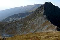 |
 On the ridge to Plačlivé On the ridge to Plačlivé |
* Loop from the East (Rohačká Dolina ):
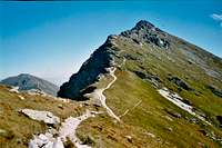
It is also possible to visit the same portion of peaks as mentioned above, plus Rakoń, from the Dolina Rohačká. The most simple consists in climbing to the end of the valley, reach Smutné Sedlo via the blue trail, do the portion already described, and descend from Rakoń via the yellow and green trails. But if you are quick, it would be a shame not to visit the beautiful lakes Rohačké Pleso. This can be done in two maneers: from West to East taking the portion of green trail via the blue, which involves a bit of going-down before reaching the other blue. Or, the fittests can make it opposite way, which means Banikovské Sedlo, and climbing most of the sharps summits of the area in the same day, with huge elevation difference... In all cases, better do this loop in anti-clockwise direction.
 |
 |
 Looking down to the Rohačké lakes Looking down to the Rohačké lakes |
Accomodation
* Campings :Camping is strictly forbidden in both National parks TPN (Poland) and TANAP (Slovakia).
However there is one campsite lead by the PZA (Polish alpine club) near the entrance of Chochołowska valley, and 2 or more campsites in the city of Zakopane, and a very good one in Pribylina (Slovakia, Račková Dolina)
* Mountain huts :
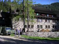
- Schronisko na Polanie Chochołowskiej (www.chocholowska.zakopane.pl), Dolina Chochołowska, Poland. This is a big hut and generally finding a place is not too hard. Take duvet and mattress anyway during sunny week ends when there is a lot of people.
- Chata Zverovka (www.chatazverovka.sk), Rohačká Dolina (near Zuberec), Slovakia. This "mountain hut" is rather a hostel because accessible by road. For this reason, it is adviseable to book it as early as possible.
Note that the hut marked "Bývalá Ťatliakova Chata" on some old maps, upper in the Rohacka valley is not a hut anymore but a place where they sell refreshments in summer.
- Žiarska Chata (http://www.dolinky.szm.sk/chata.htm), Žiarska Dolina (near Žiar), Slovakia. This is a very beautiful newly-rebuilt hut, in a very nice location, with very little frequentation. It's possible to cycle until this place (but no bicycle rental..). This starting point is ideal for the one who wants to climb Volovec together with Ostrý Roháč and Placlivé.

- Let's mention also the existence of Koliba pod Pustým (link on Hiking.SK), in Jamnická Dolina. This is not an official moutain-hut but a simple shelter, in which hikers are tolerated for sleeping despite of TANAP regulations. Leave it as clean as you found it, or even cleaner. Share the space tolerantly with other people who might want to use it too. Since this hut depend on the municipality of Pribylina, foresters or TANAP rangers have the right to forbit it when they judge it's necessary.
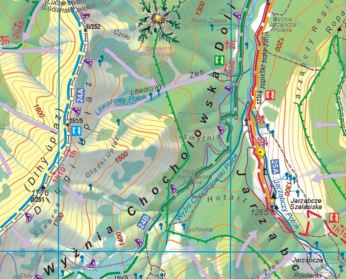
Maps
The excellent online map of Western Tatras on theMapytatr website:
Links
Wołowiec on Wikipedia, in Polish (I translated some of the informations in the overview section) :http://pl.wikipedia.org/wiki/Wo%C5%82owiec_(Tatry)
English forum on HIKING.SK :
http://hiking.sk/hk/li/forum-english_forum.html
Eric's page about Tatras:
http://h.visentin.free.fr/carpates