
-
 192183 Hits
-
 99.42% Score
-
 110 Votes
|
|
Area/Range |
|---|---|
|
|
42.90930°N / 109.3378°W |
|
|
Hiking, Mountaineering, Trad Climbing, Big Wall, Mixed, Scrambling, Skiing |
|
|
Spring, Summer, Fall, Winter |
|
|
13809 ft / 4209 m |
|
|
Under New Ownership
I adopted this page after the original owner became inactive. A decent portion of the text was written my member "Jimmyjay" and I would like to credit and thank him for all the work he put into this page. If anyone has any comments or suggestions about this page feel free to contact me and I will add updates.
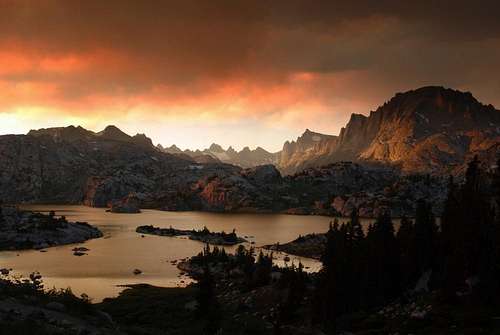
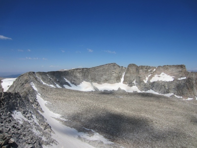
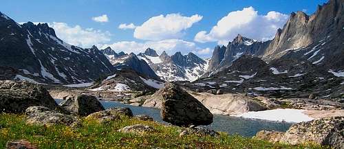 Sweeping view of the Wind River Range near Lower Titcomb Lake
Overview
The Wind River Range is a member of the Central Rocky Mountain chain. It is located entirely in Wyoming and is the highest range in the Wyoming-Idaho-Montana group of ranges. It also contains the largest system of glaciers in the American portion of the Rockies. The 63 glaciers of the range are more than in any other range of the American Rockies and surpassed in the continuous USA only by the Washington Cascades.
The "Winds" are the southernmost Continental Divide range of the Central Rockies and at their southern end (near South Pass), the Divide transitions to high desert where it crosses the Great Divide Basin. Further south the divide rises once again at the Colorado Rockies south of Interstate 80. The north end of the range ends in a high forested plateau at Union Pass. Between these two points, no road crosses or even penetrates the crest and it's entirely wilderness. The range is bound by high desert on both the west (Green River Basin) and the east (Wind River Basin).
The Winds are the apex of the contiguous United States as they are the hydro-logical triple divide. In this section of the Continental Divide, water will flow either to the Pacific via the Columbia River drainage (NW end of the range); to the Sea of Cortez via the Green/Colorado River drainage basin (most of the west side); or to the Gulf of Mexico via the Yellowstone/Missouri River basin (most of the E side) or the Platte River drainage (the extreme SE corner). No other place in the lower 48 has water flowing into this many major drainage basins.
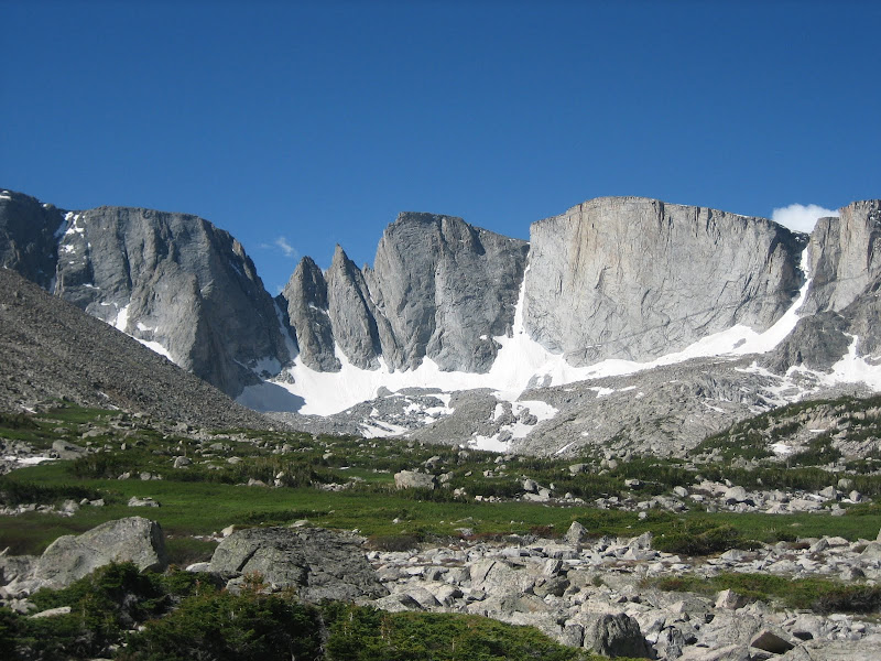
A mountaineer's introduction to the Winds is invariably either a trip to climb the popular rock climbing routes in the Cirque of Towers or an attempt of Gannett or Fremont Peaks. One trip to these common areas usually leads to many subsequent trips to the range as it typically takes the first trip to realize the general quality of climbing in the range as a whole and to fully ascertain the vastness of the range. While Gannett and "the Cirque" are certainly worthy goals (though the Cirque of Towers can be busy in July and August), the rest of the range is equally spectacular and, by California or Colorado standards, virtually empty. There are entire valleys that see only a few parties per year.
One doesn't have to be a mountaineer too long before you hear the question "have you been to the Winds?". The Winds are a special place amongst mountaineers. Even those that have climbed in the Andes, the Alps, or Alaska speak fondly of their time spent here.
"Glacial Artistry in the southern Wind Rivers is unsurpassed" - Tom Turiano
Range Sections
The Winds can be geologically divided into two sections. The first is the gneissic/glacial, alpine northern half with the second being the granitic, drier southern half. Most visitors, however will approach the range as three sections due to trailhead arrangement and length of the range.
North: The northern third of the range is often regarded as the wildest and least visited overall. Large glaciers and high peaks with long and rugged approaches dominate here. However cross country travel above treeline is relatively simple and one can spend days hiking from one massive alpine lake to the next camping anywhere you want as water and soft grasses can be found everywhere. The only crowded spot is the area around Titcomb Basin, Island Lake and Gannett Peak. Two-day approaches are common to all the alpine, ice, rock and scrambling routes.
Middle: This area is somewhat lesser traveled. Mountaineers you meet here tend to already have a couple Winds trips under their belts. 2-3 day approaches to Alpine Lakes, Mount Bonnevillle, Roberts Mountain (highest of the central range) or more obscure rock walls and pinnacles near sometimes unnamed lakes and valleys with no trace of a trail. East of the divide the areas is owned by the Wind River Indian Reservation which makes for the only access issues in the entire range.
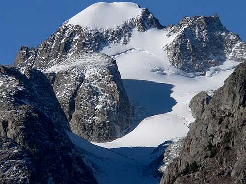
South: Crowned by Wind River Peak and famous for its many cirques including the well-visited Cirque of Towers and dozens of equal quality but less visited peaks and walls. One day approaches and clean, sweeping granite are the attractions. Though less alpine than the northern section, ice axes can still be crucial.
 Mount Woodrow Wilson in the northern end of the range Mount Woodrow Wilson in the northern end of the range |
 Mt. Bonneville in the central section Mt. Bonneville in the central section |
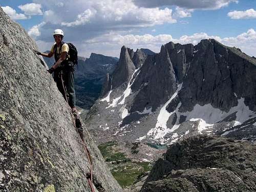 Climbing Wolf's Head in the southern section Climbing Wolf's Head in the southern section |
Access Points
Because there are more than 10 major access points for this vast range and several others as well, it is beyond the scope of this page to give detailed information for them all. You can find detailed information about the various trailheads by visiting individual mountain pages. Here is a listing of the ones most used though and which areas they provide access to. Also see this page for more information about access points into the Wind Rivers.
| Trailhead | Aspect/Nearest Town | Areas Accessed | Notes |
| Trail Lake | NE side - Dubois | Glacier Trail Gannett Peak Downs Mountain Ross Lake |
Start of the Glacier Trail approach for Gannett Peak |
| Dickinson Park | E side - Fort Washakie | Cathedral Lakes Bears Ears Trail Roberts Mountain |
This approach goes through the Indian Reservation and there have been issues with closures and fees. Currently, the road is open to the public, but you must buy a tribal fishing permit, which is not cheap. |
| Worthen Meadow | SE side - Lander | Coon Lakes Trail Deep Creek Lakes Wind River Peak |
Approach for the east side of Wind River Peak |
| Big Sandy | SW side - Farson | Cirque of the Towers Wind River Peak Temple Peak |
This trailhead utilizes a long, 40 mile dirt road starting a couple miles east of Farson off Highway 28 and can be very rough on passenger cars. Despite this, it's popular as it's the primary approach for The Cirque. |
| Elkhart Park | W side - Pinedale | Pole Creek Trail Jean Lakes Titcomb Basin Gannett Peak group Indian Basin |
This is the most popular trailhead in the range and located about 15 miles from Pinedale along a paved road. Most people climbing Gannett Peak start here as well as backpackers headed to Titcomb Basin which is a long 15 mile hike away! |
| Green River Lakes | NW side - Pinedale | Roaring Fork Trail Highline Trail Tourist Creek Route Downs Mountain |
This trailhead is also about 40 miles from Pinedale along a very washboarded dirt road that ends at Lower Green River Lake. Popular with backpackers using the Highline Trail but very remote and secluded areas can be reached from here. |
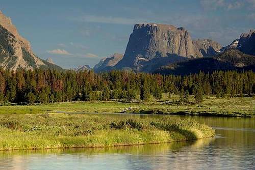 Squaretop Mountain from Green River Lakes
Wind River Range News/Facts
June 2012 - Grizzly Bears Migrating South In late May, a hiker photographed a grizzly bear in the Sinks Canyon area of the Wind River range. Over the past 5-10 years, the grizzly bear population has grown and have slowly migrated south. Today they are found throughout the entire range. Article
June 2008 - Missing climber's body found. In November 2007, local climber Clay Rubano went missing and in June that following year, a private volunteer search party found his body near Sheep Bridge. Full condolences to his friends and family from the climbing community.
September 2007 - Peter Absolon killed. In an incident that puzzled mountain users and those who were taught not to trundle at a young age, Isaac Rodolph went along the top of the popular climbing wall at the head of the Leg Lake Cirque and observed one boulder that he tossed instantly kill local climber and NOLS instructor Peter Absolon, who was leading a pitch below on 11Aug07. Rodolph has not been charged with any criminal activity.
August 2007 - Trout Creek Road Closure Update On 8Aug07 the tribes announced that access to Dickinson Park/Moccasin Lake will resume. Road users are now expected to purchase the reservation "fishing" permit to drive the road to the FS trailheads. Some users have adopted a use-at-your-own-risk attitude and are employing the passive-boycott technique of civil disobedience, noting that the road was built by the CCC for public use. It's your call.
January 2007 - Russian rocket lands at southern end of range. On 5Jan07, an SL-4 rocket, launched from the Baikonur Cosmodrome in Kazakhstan, dropped a spent booster into the atmosphere over North America. The rocket was used to deliver a French COROT telescope. Streaking over the skies of Colorado and Wyoming at 6am, its intended deployment zone was in the Pacific Ocean. Though the story was registered via the AP in Riverton, the as yet unlocated debris landed somewhere in the South Pass region at the southern end of the Wind River Range.
User Impact Though we are at least two decades past the necessity of the campfire and the advent of the lightweight backpacking stove, there are still people entering the wilderness areas, gathering wood and burning it. Popular areas have long been stripped of available wood and some users are unfortunately resorting to aggressive wood-stripping measures. This has led to the banning on campfires in some areas (and the unsightly campsites they leave behind have been posted) but there are those who simply ignore the bans. Signage and bans have had limited success in instructing users to rely on lightweight stoves instead of campfires. Other user impact issues include the Giardia Lamblia parasite (water should be filtered or treated) and human fecal material causing camping perimeter bans near lakes. Solutions appear to be education based.
Glacial Shrinkage Like elsewhere around the globe, the Wind River glaciers have shrunk dramatically in recent decades. Unlike many areas, there are ongoing studies being conducted to monitor the shrinkage. The Upper Fremont Glacier, in fact, has been given "benchmark" glacier status. Because local populations depend on glacial runoff each year, and the Wind River glaciers are a natural reservoir for the Big Horn-Yellowstone drainage system, the shrinkage is of immediate local concern. For this reason, the state has begun a unique $8.8 million study program involving pro-active cloud-seeding for the glaciers of the Wind River Range.
December 2006 - More Glacier Studies Appear With the largest glaciers in the American Rockies, the Wind River Range has become a focal point of study and measurement for the changing climate. One of the studies (Wind River Glacier Study) was recently given a $217,000 grant from the state legislature. The study identifies 63 Wind River glaciers and measures the amount and rate of change of the size of the glaciers due to rapid overall climate change. A few of the more accessible glaciers, such as Dinwoody and Knifepoint, have been studied since the 1980s but many of the snow samples taken for data collection in the past have focused on the problem of acid rain deposition along the continental divide. Therefore, new methods sample runoff to find the percentage of glacial content.
The Dinwoody Glacier (one of the three largest) had a surface area of 3.47 square kilometers half a century ago. This measurement shrunk to 2.33 square kilometers in 1999. Since glacial melt occurs more in mass than surface area, it can be estimated that 40% of the average seasonal mass of the glacier has been released; an historically unprecedented occurence. This latest study measures the isotopes of water in Dinwoody Lakes area (downstream from several of the larger glaciers) to measure how much of the water is ancient but recently released as opposed to normal seasonal runoff. If the glaciers are shrinking, then the mass has either turned to meltwater of has disappeared through sublimation. The effects of sublimation are difficult to measure but as much as 15% of current meltwater is from ancient glacial mass [1]. This is then compared to local climate models to account for yearly fluctuations. Glacial samples were also taken on the glaciers themselves in August this past summer.
The change in mass of the Wind River glaciers has already seemed obvious to mountaineers, flightseers and glaciologists but the recent political interest in fueled by economical interests. With desert basins below, Wyoming's agricultural industry depends on the glacial icepack, for water storage. Though the state of Wyoming is eager to fund explorative studies for the amount and rate of change, any action plan concerning the effects is beyond reach of the state. Given the mathematical rate of change, the fastest since their origin, the Wind River Glaciers will likely recede to shaded fragments in this century.
Roads and Trails Issues Some trails shown on current topo maps may not be easily passable or may not exist in reality. With the national deficit/funding status in economical crisis, the Forest Service is no longer maintaining as many roads and trails in the Wind River Range as it was previously. Several have been removed from the inventory system and will no longer be maintained. The Sublette County side of the range (west side) has long had better roads to trailheads (and correspondingly sees the reward from the tourist dollar). The Fremont County side (much of which has access problems due to the Wind River Indian Reservation) is, objectively, decades behind the Sublette County side in this regard. This will be rectified to some extent by the paving of an additional several miles of the Louis Lake Road from Sinks Canyon to Frye Lake using state funds. Maintaining current access will continue to be an issue in the future.
Air/Water Quality Issues Air in the Wind Rivers is not what it was decades ago, even with the establishment of the Clean Air Act. Older mountaineers recall summit days when distant views of ranges such as the Tetons and Uintas were clearer. Those days are less now and a general haze is often discernible (particularly with the increase in fires). Though this coincides with coal-burning power plants and natural gas extraction in southwestern Wyoming as well as a sharp increase in population in the Salt Lake Valley of Utah (further up the prevailing jet stream) a chief factor is the exportation of pollution from California and globally. The quality change has been measured in alpine lakes of the range in the form of acid rain. Aside from the issue globally, it would seem inherently plausible that Wyoming, as the least populated state, should correspondingly have the clearest air. USGS deposition monitoring data. State Air Quality/Visibility Site.
Ski Resort The range supports one ski resort called White Pine, located near Pinedale, on the snowier, upslope side of the range. Actually, the area surrounding the range (Fremont and Sublette Counties) is very sparsely populated and Sublette County on the west side is one of the least populated counties in the United States. The only place to purchase amenities at the western foot of the range is Pinedale, a tiny mountain community that is fond of climbers/hikers and caters to outdoor tourism. Locals in Pinedale often have loads of untouched mountain terrain to ski all winter long.
Hiking and Backpacking
The Wind Rivers are one of the best places for long distance trekking in the entire country primarily because the crest of the range is over 15 miles from any road. No matter which side you approach from, there are long trails that can take you deep into a beautiful wilderness and offer complete solitude in certain places. If you are willing to head off trail a little bit you can see even more remote places without even doing much scrambling. Described below is the most popular and most classic trekking route for each side of the Wind Rivers.
West Side
Highline Trail - This is the main trail that stretches much of the Winds starting at the Green River Lakes and heading south along the west side of the crest. There are many ways to make the trek but most people will make some type of through hike from Green River Lakes to Elkhart Park with a car shuttle. The Highline Trail will connect these two popular west side trailheads however a better way to make the trek that will provide more beauty is to leave the Highline Trail where it junctions with the Shannon Pass trail and once at Peak Lake, continue over Knapsack col and drop into Titcomb Basin. Once here, you can make a side trip to Indian Basin and end the hike along Seneca Lakes and past Photographers Point to Elkhart Park. The only off trail section on this variation is from Peak Lake to Titcomb Basin but well worth the little extra effort. If you'd rather stay on trails the whole time simply continue over Shannon Pass to the Jean Lakes which will take you back to the Highline Trail near Upper Seneca Lake.
 Peak Lake Peak Lake |
 Island Lake and Titcomb Basin Island Lake and Titcomb Basin |
Another variation of this thru-hike which has a considerably large amount of off trail hiking and more route-finding is to completely forgo the Highline trail and start hiking up the Roaring Fork Trail from the Green River Lakes trailhead. The trail will end shortly below Native Lake and from here you'll cross the Roaring Fork and hike a short steep hill to Native Lake, pass by Crescent Lake, and hike along the high plateau to the east of the Highline Trail which will be in the Green River valley well below you. Depending on the weather you can then easily gain the crest and summit Downs Mountain (Class 2) and walk the crest over Point 13,062, Yukon Peak, Klondike Peak and then descend into Tourist Creek. You could also stay off the crest a little longer and hike past Daphne Lake and above Bear Lake into Bear Basin. Many variations here but this part of the Winds are probably the least visited and there are less bugs! See the links below for excellent trip reports of various thru-hikes along the west side of the crest.
Excellent thru-hike TR of the Wind Rivers
East Side
Glacier Trail - This route is exclusively on trail with a little less off trail options but the route is so beautiful it is worth the trip. Many climbers seeking the summit of Gannett Peak use this as their approach. I have not yet done this route so I will direct you to the excellent description Redwic wrote linked to the left.
 Downs Fork Meadows Downs Fork Meadows |
 Gannett Peak from the Glacier Trail Gannett Peak from the Glacier Trail |
Wind River High Route
In more recent years, a cross country route has gained popularity and is becoming a staple testpiece for mountain runners and more ardorous backpackers. This is called the Wind River High Route, originally coined by Andrew Skurka. Runners in 2020 have started to try and repeatedly best the FKT (Fastest Known Time) for this recent route. Climbers though will likely find themselves using this route various times as it is generally the path of least resistance through various parts of the range. The majority of the high route is on the east side of the continental divide, and trailheads at both the north and south ends are also found on the east. The route is nearly 100 miles long and extends the entire length of the range.
The high route ascends over two of the Wyoming 13ers, the northern 13er Downs Mountain (which is actually the northernmost 13er in the entire North American Rocky Mountain chain stretching from the peaks of northern New Mexico all the way to the Brooks Range in northern Alaska), and the southern 13er Wind River Peak.
Technical Alpine Climbing
A majority of Wind River peaks are technical ascents and the range offers some of the best alpine rock climbing and mountaineering in the country. Most standard routes tend to be Class 3-4 on solid, enjoyable rock punctuated by short sections of trad climbing on ridges and arêtes, of an unsustained nature. This is perfect for remote wilderness mountaineering and climbing. For rock climbers, there is valley after valley of large walls and a lifetime of new route potential. For mountaineers, throughout the range there are glaciers, snowfields, and couloirs offering fantastic snow climbs and requiring the use of axes and crampons.
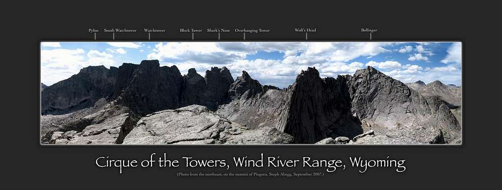
Keep in mind that a Grade III, 5.8 can seem pretty stiff when you're two days away from the nearest trailhead. Many climbers have been spanked by convincing themselves in advance that Wind River routes are gimmes. Though not sandbags (these exist too, of course), they are committing. Another notable feature about the Winds is that mountaineers travelling the west side of the range can pick out the distant high peaks and though the east side is generally more dramatic up close, the highest peaks are only road-visible from great distances because there are two/three additional crests that parallel the divide to its east that are only a few hundred feet lower in altitude. This makes the crest peaks "disappear" as one nears this wide mountain range. The table below describes some of the classic alpine climbs found in the Wind River Range ordered from north to south. All the climbs listed below have either 3 or 4 stars and will take you to the summit of a peak. Note that there are numerous rock climbing routes that lead to many smaller peaks around Big Sandy and the Cirque of the Towers so this list is by no means exhausting. Go out and explore the climbing potential for yourself!
| Route | Photo | Peak | Rating | Brief Description |
| Tower Ridge |
 |
Mount Helen | Class 5.7 | As you're looking at the West Face of Mt. Helen from Titcomb Basin, the Tower Ridge starts by ascending the gentler ridge on the right side of the steep West Face. This involves about 1,000' of climbing, with lots of 5.7 sections in the middle and some 4th class to easy 5th in the beginning and near the top of Tower 1. A couple more towers are passed over before reaching the narrow summit ridge, which holds the crux. |
| West Face Right |
 |
Mount Sacajawea | Class 5.9 | From Titcomb Basin, begin scrambling directly up the lower west face of Sacajawea. Aim for the ridge side of the face and reach a large left-facing dihedral. Climb 4 pitches of 5.5 to 5.8 climbing with good pro. There is a short 5.9 crux. Above the dihedral, step onto the face and climb another 4 pitches and scramble to the summit. Sacajawea Peak also has other various low 5th class routes but it is one of the more difficult peaks to reach in the entire range. |
| West Ridge |
 |
Turret Peak | Class 5.7 | See the linked SP page written by Sarah Thompson. This route is fantastic and one I recommend to all climbers seeking adventure in the Wind Rivers. |
| North Face |
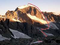 |
Gannett Peak | Class 5.4 | This route has more glacier and steep snow/alpine ice climbing than rock climbing. Whatever rock that's on the route is low 5th class and the steepest snow found is 45-50 degrees. This is however an excellent alternative to the standard route on Wyoming's highest peak. See the linked SP page for more information. |
| North Ridge |
 |
Ellingwood Peak | Class 5.6 | The North Ridge of Ellingwood is one of those Rocky Mountain alpine adventures that is familiar-sounding to many, but few actually put in the miles required to climb it. You'll find significant sections of 5.5 - 5.6 climbing on almost all of the 10 pitches on this route. The crux will vary a bit depending on the exact path chosen, but expect all manner of 5.6 climbing, including face, cracks, and overhangs. This long route finds people descending in the dark quite commonly! |
| Hole in the Wall |
 |
Ambush Peak | Class 5.10 | This route begins above the Big Sandy opening. The route follows up and right, below an arching flake system for two pitches to a large ledge. Continue up and right on a 5.9 face to ledges and up for 3-4 pitches to a huge, protected ledge behind a series of flakes (cairn). Continue up the face (5.9 or 10), heading for a 200 foot long dihedral which can be seen from ground. At the top, trend right onto the North Face and follow face and cracks for another 5-6 pitches to the summit. This route is an ultra classic Grade 5 climb. |
| West Buttress |
 |
Musembeah Peak | Class 5.10a | This is the best line in the central Winds located above Baptise Lake. It's character is that of a mountaineering rock climb, with route finding issues, sometimes unpredictably wet patches, but still, generally enjoyable climbing on good rock. The final pitches provide withering exposure and wonderful movement up sustained cracks and chimneys. Ledges are timely and comfortable. Start up the chimney/couloir at the base of the face and trend left after a pitch, continuing up the lower half of the buttress (occasional 5.8) following cracks to the laid back central section. Scramble to the base of the left buttress, then continue upwards, on or a little right of the crest to the the summit. 5.9-5.10, 4 or 5 pitches. |
| Minor Dihedral |
 |
Haystack Mountain | Class 5.9 | This fantastic route is a real adventure, with a difficult approach above Deep Lake, 10 pitches of excellent but sustained granite climbing and a tricky descent. Real classic though! |
| Northeast Face - MP |
 |
Pingora | Class 5.8+ | Perhaps the best moderate climb in Wyoming...period! Start early and go on a weekday. This Cirque of the Towers route is probably the most popular one and for a good reason. The linked pages both have great descriptions. |
| East Ridge - MP |
 |
Wolfs Head | Class 5.6 | Another Ultra classic in the Cirque! This route goes up the knife blade east ridge of Wolfs Head. To get on the ridge there are 2 different options. The easiest way to gain the ridge is to scramble 4th and 5th class up the gully in between Pingora and Tiger Tower, summit Tiger Tower then do 2 40 foot raps onto the east ridge of Wolfs Head. The other way is to scramble 3rd and 4th class up the south face then up to the ridge. Once on the Ridge the climb goes at about 10 pitches to the summit but many of these can be combined or simul-climbed. |
Geology
The Wind River Range is a major barrier between western and central Wyoming and it separates the Wind River Basin to the northeast from the Greater Green River Basin to the south and southwest. The northeast flank of the Wind River Range consists of a 96-mile-long band of Paleozoic sedimentary rocks exposed in a series of hogbacks and dip slopes that dip eastward into the Wind River Basin. The core of the range exposes an extensive area of some of the oldest Precambrian rocks in the state. The southwest flank of the range is characterized by an extensive thrust fault system, with Precambrian rocks thrust south and southwest onto relatively flat-lying Tertiary rocks in the Green River Basin. The fault system extends eastward where Precambrian rocks in the South Pass area were thrust over Tertiary rocks of the northern Great Divide Basin. This ancient thrust fault has been measured to have a dip angle of about 30 degrees to the east.
The rocks exposed in the high Wind River peaks are a combination of Precambrian Gneiss belts and Granite plutons that have been shoved upwards during the Laramide orogenic event that uplifted the Wind River block 50-70 million years ago. Large scale tectonic activity occurred as the now disappeared Farallon Plate subducted under the North American plate at a very shallow angle and slid against its base. This input huge compression and upward forces on the North American plate above and created a series of huge thrust belts (like the one described above) forcing rock deep beneath the paleo-surface upwards over 10,000 feet in places. Overlaying sedimentary rocks began eroding away as the older, Archeon aged granite plumes and orthogneiss rocks reached the surface. Remnants of these sedimentary rocks can be found as steep hogbacks along the eastern flank of the range where you can see where they were forced up and eroded away. Today, the highly resistant granitic rocks stand proudly high above the surrounding sedimentary basins and countless glacial events have carved out the U shaped valleys and steep cliffs we now see in the Winds.
The South Pass area at the south end of the Wind River Range hosts a sequence of Archean (more than 2.5 billion years old) supracrustal metamorphic rocks called a greenstone belt that contains the state’s principal gold deposits as well as iron ore deposits. Besides being an important point along the Oregon Trail, South Pass was also the site of extensive lode and placer gold mining in the 19th century and of a surface iron ore mine and mill in the 20th century. The area remains attractive for gold prospectors and has a rich and well-preserved history.
See the images below for a simplistic visual representation of the geology in the Wind River Mountains. Although the processes that formed both the rocks in the Winds and the mountains themselves are significantly more complex than what I described here, this gives a general idea about the formation and structure of the Winds as well as what type of rocks are found here. It's also worthy to note the northern half of the range is mostly Gneiss and orthogneiss (metamorphosed Granite) while the southern half is more pure granite which gives the Cirque of the Towers its great climbing.
 Generalized cross section view through the Wind Rivers. Generalized cross section view through the Wind Rivers. |
Nomenclature Note
In much of NW Wyoming, the Wind River Range in particular, peaks have two names. This is because there are the traditional names, long-used by locals and preferred by mountaineers, and names the USGS later printed on maps for (usually) undocumented reasons. Generally, these USGS names have never had common usage and, given most mountaineer's reluctance to name mountains after politicians or non-climbers, it's not surprising for them not to have caught on. So if you see a reference to a peak but can't find it on a government map, this could be the reason. There are dozens of examples in the section of the Rockies.
Local Towns
There are numerous small towns that surround the flanks of the Wind River Range all of which offer various services and culture. I have ordered the towns in a clockwise direction around the range and describe what amenities are found in each below.
Dubois is located on the extreme northeastern corner of the Winds and is nestled in the valley between the Absaroka and Wind River mountain ranges. The Wind River meanders peacefully through town on its way to join the Yellowstone River system. Named after Fred Dubois, a former Idaho senator, the town has roughly 1,000 people and offers all the necessary amenities. In fact, Welty's General Store used to be a common stop for Butch Cassidy who resided near Dubois in the late 1800's. Fewer people venture into the Winds from this side which is guaranteed to make for a more secluded and slower paced outing.
Located on the Indian Reservation, Fort Washakie is home to about 1,800 people and is named after a US army post stationed at the location in 1869. It is said the the grave of Sacajawea is located a few miles north of town. If anyone can recommend places to eat or stay in Fort Washakie, it would be much appreciated as I have never been here.
Lander is the largest town along the Wind Rivers with about 7,800 people and is the county seat of Fremont County. All amenities are found here including a nearby Wal Mart in Riverton just a short drive away, numerous restaurants and hotels, and a handful of dude ranches. Lander is also the home of NOLS, the National Outdoor Leadership School founded by mountaineer Paul Petzoldt. They are world-renowned for their college-credit mountaineering courses, guiding, and progressive low-impact studies and promotions. Some of the very first NOLS courses were in the backcountry of the Wind River Mountains! Lander has extensive cultural history ranging from various types of art to advances in climbing and mountaineering.
Lander is also a well known sport climbing center with hundreds of routes that have been established on the Dolomite and Limestone cliffs of Sinks Canyon. The huecos and monodoights of Wild Iris near Atlantic City, are legendary. There are two guide books for the sport climbing areas. Lander Rock (White and Collins) and Lander Sport Climbs (Bechtel). This up-and-coming climbers town also hosts the International Climbers Festival and all mountaineering shops and manufacturers in the region are located here, with the key exception being the Great Outdoors Shop in Pinedale.
Farson is a tiny settlement located at the intersection of US Highway 191 and State Highway 28 home to just 300 people. There isn't much more than a single gas station and a small convenience store here.
Home to about 2,000 people, Pinedale is the main kickoff point for all trips on the west side of the range. It's the county seat of Sublette County and also has all necessary amenities including a new recreation center with a large pool, weight room, basketball court and an indoor track. This small town is a beautiful place to live, despite the recent surge of drilling activity as the area is proven to have excellent oil and gas deposits. A paved road leads 15 miles northeast out of Pinedale, passing above Fremont Lake (second largest natural lake in Wyoming) and ends at Elkhart Park which is likely the most popular trailhead in the Winds. The only ski area in the Wind Rivers (White Pine) is only a short drive out of town. Pinedale is also home to The Great Outdoors Shop. This is the only outdoor shop on the west flank (unless you go to Jackson) and they are very nice. They will gladly help you in planning your trip, give you suggestions and current conditions, and even shuttle your car if needed. I believe as of 2011, they charged $75 to shuttle your vehicle from the Green River Lakes trailhead to Elkhart Park or vice versa.
Wildlife Concerns
Bears - There are both Black Bears and Grizzlies in the Winds. Black Bears range throughout the region. Grizzlies used to be contained to the northern quarter of the range but now roam throughout the range from the roads to treeline. The Grizzly Bear was once an endangered species. Since being successfully listed with the Endangered Species Act, the bear population is now to the point where the bear is being delisted. The issue as pertains to the Wind Rivers is that the population has increased to the point where, in search of new range, grizzlies have migrated from their historical (20th century) habitat in the Absaroka Range and Yellowstone Plateau along the continental divide and into this range. This has led to human encounters and associated problems. Because the grizzly is not crucial to this range and vice versa, the presence of the species is currently an issue with some saying the recovery efforts were too successful and others thinking that the bear population still needs protection. The current state plan is to make the area south of Boulder Creek off-limits to the bear. The federal plan allows the bear population to continue to expand. Most mountaineers and the general public would prefer not to encounter grizzlies while in the range yet confrontations are at an all time high. When delisted, the states' plan will call for a base population of 600 and will allow certain kills (as opposed to the current plan in which problem bears are airlifted into high wilderness). There are several sides to the issue but one certainty is that the population has returned to the Wind River Range and is growing.Mosquitos - Though there are bears in the range, the most notorious pest is the mosquito. The Winds are a range with a massive amount of water in the form of thousands of lakes, pools, meadows, marshes and waterfalls. First time visitors are normally surprised at the amount of lakes encountered on the approaches (particularly since the range is in a desert). While attractive, it makes the area a mosquito breeding ground. People that have forgotten repellant are quick to either make the long drive down from the trailhead, or accost a fellow traveler. It is that important, however the amount of mosquitos highly depends on the location, time of day, amount of shadows, the time of year and the year itself. Typically, the bugs (including biting Horse/Deer Flies and Gnats) are at their peak from mid-June to mid-August which is the wettest periods. They are less in numbers if there has been a freeze or a lot of wind. Also, the more popular areas like Titcomb Basin are much worse than the rarely visited places like Bear Basin.
Marmots - Also known as Yellow-Bellies, Rockchucks and Whistle Pigs, they will approach you in camp because they equate humans with handouts. Our food, however is not good for them. They bite and when you leave camp they can chew through your tent to get any food you have left there. In some areas, hanging or gear-caching is the only alternative to gear damage. I have found over the years however that marmots have a hard time chewing through modern tent fabric as long as it is taunt.
Giardia Lamblia - This is the parasite that causes Giardiasis. It's a serious affliction, likely spread through feces and contact. People have contracted it in the Winds due to livestock use. It is found in the fresh water you use to drink and cook with and can only be killed by boiling the water for at least 5 minutes at the altitudes found in the Winds. This uses up valuable fuel so you might consider water purification. Some people will say you can't be safe enough while others will say there isn't too much Giardia in the Winds and they will just drink the water sound in flowing streams. If you are prone to illness, best to purify or boil your water but if your stomach is tough like mine, adding chlorine drops should kill the parasite and will save you time, effort, and weight but not everyone can handle the chlorine taste.
Fish - The fishing in the Winds is legendary. It includes several species of Trout but mostly Cutthroat and Brookies. A state fishing permit is required and can be purchased in any of the surrounding communities. Below treeline the fish can be cooked with small fires when bans are not in effect but above treeline a stove is required.
Other wild animals include Bighorn Sheep found mostly in the northern half of the range, Moose in many marshy areas, Elk found throughout the range, Wolverine having large populations but hard to find, Wolves and Coyotes. In fact, the northeastern end of the range, in the Dubois rain shadow, the area is particularly dry most winters. This dryness allows the Bighorn Sheep Refuge to flourish and is the home of the world's largest winter herd.
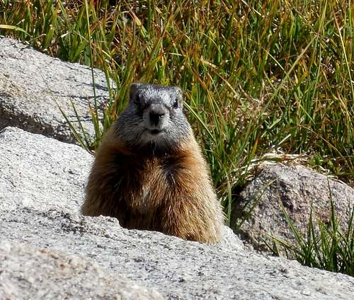 An incredibly annoying marmot!
Highest Peaks
The 13ers
The northern Wind River Range is home to the vast majority of the 13ers in the state of Wyoming. In fact, of the 35 ranked 13ers in Wyoming, all but three of them are found in the Winds. Of the 32 thirteeners in the Winds, 31 of them are in the northern half of the range. Wind River Peak is the lone 13er to the south. This is arguably the largest concentration of high peaks in the entire lower 48 outside Colorado. See the table below for the complete list of 13ers in the Winds as well as their YDS difficulty. Note that only ranked peaks are listed which are peaks that have at least 300 feet of clean prominence.
Table format below originally created by musicman82
| Rank | Image | Peak Name | Elevation | Prominence | YDS Class | County | Quad | Map Link |
|---|---|---|---|---|---|---|---|---|
| 1 |  |
Gannett Peak | 13,804 | 7,076 | 3 | Fremont/Sublette | Gannett Peak | Map |
| 2 |  |
Fremont Peak | 13,745 | 1,184 | 3 | Fremont/Sublette | Fremont Peak South | Map |
| 3 |  |
Mount Warren | 13,722 | 982 | 3 | Fremont | Gannett Peak | Map |
| 4 |  |
Mount Helen | 13,620 | 840 | 4 | Sublette | Gannett Peak | Map |
| 5 |  |
Turret Peak | 13,620 | 640 | 5.0 | Fremont | Fremont Peak North | Map |
| 6 |  |
Mount Sacagawea | 13,569 | 469 | 4 | Fremont/Sublette | Fremont Peak North | Map |
| 7 |  |
Jackson Peak | 13,517 | 737 | 3 | Fremont/Sublette | Fremont Peak South | Map |
| 8 |  |
Mount Woodrow Wilson | 13,502 | 522 | 5.1 | Fremont/Sublette | Gannett Peak | Map |
| 9 |  |
Bastion Peak | 13,494 | 674 | 3 | Fremont/Sublette | Gannett Peak | Map |
| 10 |  |
Mount Febbas | 13,468 | 728 | 2 | Fremont | Fremont Peak North | Map |
| 11 |  |
Sunbeam Peak | 13,460 | 600 | 3 | Fremont | Fremont Peak North | Map |
| 12 |  |
Flagstone Peak | 13,450 | 830 | 2 | Fremont/Sublette | Gannett Peak | Map |
| 13 |  |
Pinnacle Ridge | 13,365 | 345 | 4 | Fremont/Sublette | Gannett Peak | Map |
| 14 |  |
Downs Mountain | 13,349 | 1,569 | 2 | Fremont/Sublette | Downs Mountain | Map |
| 15 |  |
Mount Koven | 13,265 | 445 | 5.3 | Fremont/Sublette | Gannett Peak | Map |
| 16 |  |
The Sphinx | 13,258 | 318 | 3 | Fremont/Sublette | Gannett Peak | Map |
| 17 |  |
Spearhead Pinnacle | 13,220 | 320 | 5.3 | Fremont/Sublette | Gannett Peak | Map |
| 18 |  |
American Legion Peak | 13,205 | 945 | 3 | Fremont/Sublette | Gannett Peak | Map |
| 19 | ") |
Bete Noire (Brown Cliffs HP) | 13,198 | 1,058 | 3 | Fremont | Fremont Peak South | Map |
| 20 |  |
Wind River Peak | 13,192 | 2,572 | 2 | Fremont/Sublette | Temple Peak | Map |
| 21 |  |
East Twin Peak | 13,185 | 405 | 3 | Sublette | Gannett Peak | Map |
| 22 | |
Peak 13180 | 13,180 | 320 | 3 | Fremont/Sublette | Gannett Peak | Map |
| 23 |  |
Desolation Peak | 13,155 | 935 | 3 | Sublette | Gannett Peak | Map |
| 24 |  |
Split Mountain | 13,155 | 575 | 3 | Sublette | Gannett Peak | Map |
| 25 |  |
Henderson Peak | 13,115 | 775 | 4 | Sublette | Gannett Peak | Map |
| 26 |  |
Klondike Peak | 13,114 | 664 | 2 | Sublette | Gannett Peak | Map |
| 27 | ") |
Peak 13062 (South Downs Mountain) | 13,062 | 442 | 2 | Fremont/Sublette | Downs Mountain | Map |
| 28 | ") |
Ellingwood Peak (Harrower Peak) | 13,052 | 912 | 4 | Sublette | Fremont Peak South | Map |
| 29 |  |
Bow Mountain | 13,020 | 680 | 3 | Sublette | Gannett Peak | Map |
| 30 |  |
Mount Whitecap | 13,020 | 600 | 4 | Sublette | Gannett Peak | Map |
| 31 |  |
Knife Point Mountain | 13,001 | 661 | 3 | Fremont/Sublette | Fremont Peak South | Map |
Southern Winds
The southern section of the range houses only one of the 13ers shown in the table above and that's Wind River Peak. Despite the lower elevation, the southern part of the range is in some ways more spectacular than the north. Listed below are some of the higher peaks surrounding Wind River Peak and the Cirque of the Towers. Many of these peaks offer the best alpine rock climbing in the entire American Rocky Mountain chain. This table is by no means comprehensive as there are well over 100 peaks in the Wind River Range between 12,000 and 12,999 feet.
| Rank | Photo | Name | Elevation (Ft) | Prominence (Ft) |
| 1 |
 |
Temple Peak | 12,972 | 1,472 |
| 2 |
 |
Lizard Head Peak | 12,842 | 1,902 |
| 3 |
 |
Little El Capitan | 12,825 | 485 |
| 4 |
 |
Roberts Mountain | 12,767 | 1,587 |
| 5 |
 |
Wolverine Peak | 12,631 | 1,331 |
| 6 |
 |
Mount Lander | 12,623 | 803 |
| 7 |
 |
East Temple | 12,620 | 960 |
| 8 |
|
Musembeah Peak | 12,593 | 733 |
| 9 |
 |
Mount Bonneville | 12,585 | 805 |
| 10 |
 |
Atlantic Peak | 12,490 | 2,163 |
 Spectacular view of Wolverine Peak. The climbing potential looks endless!
Management
The entire west side is managed by the Bridger-Teton National Forest. A large portion of the range east of the Continental Divide is part of the Wind River Indian Reservation (Eastern Shoshone and Northern Arapaho tribes). The only Reservation trailheads accessible to the public without a native concessions vehicle are Saint Lawrence Basin and Mocassin Lake. For peaks or approaches anywhere on the Reservation a fishing permit must first be obtained from the tribes. It can be purchased at various stores in Lander, Fort Washakie, Dubois or Riverton.
Access issues have been a problem in the Dickinson Park area in recent years, and it may be easier to approach from Big Sandy. Currently, a Reservation fishing permit is required for driving the road to Dickinson Park. Here is a PDF showing the fees and regulations as of 2011. To make sure you are aware of the current fees and regulations, you are advised to use this contact information:
Shoshone & Arapaho Tribes
Fish and Game Department
PO Box 217
Fort Washakie, WY 82514
307-332-7207
North and south of the Reservation the mountains east of the Continental Divide are managed by Shoshone National Forest.
Lander Webcam
 Current webcam of Lander, Wyoming on the east side of the range.
Guidebooks
Kelsey, Joe (1994). Climbing and Hiking in the Wind River Mountains, 2nd Edition; Falcon Press - Guilford, CT >>>>Joe Kelsey released the 3rd Edition of his book in the summer of 2013
Turiano, Thomas (2003). Select Peaks; Indomitus Books - Jackson, WY
Bechtel, Steve (2008). Cirque of the Towers & Deep Lake; First Ascent Press - Livingston, MT
Bonney, O.H. (1977). Guide to the Wyoming Mountains, 3rd Edition; Swallow Press - Chicago, IL
Guides and Outfitters
Outfitters are popular in the Wind River Range. They can provide horses or equipment/food drops.
West side outfitters operate from Pinedale.
East side outfitters operate from the Wind River Indian Reservation, Lander or Dubois.
Climbing Guides operating in the range include:
Exum
Jackson Hole Mountain Guides
Another approach option is Llama packing
Saintgrizzly - Mar 9, 2009 3:49 pm - Voted 10/10
Lower 48 Glacier Info of InterestHere's a link (see below) to current glaciation infomation in the U.S. Lower 48. Wyoming and Montana, of course, top the Rockies in glacial area (actually, have more square kilometers of glaciers than any other state except Washington, which is in a class by itself). Interesting that the Wyoming glacier total is less than 5 square kilometers more than that of Montana—but note that not all glaciers in those states are in the Wind River Range or GNP. Gannett Glacier, with an area of 3.3 kilometers is currently the largest U.S. Rocky Mountain glacier. I have been unable to locate an accurate glacial area figure isolating a total for either the Winds or GNP. The consensus (which I don't dispute) seems to be that the Winds have more glacier area than GNP, but I've never seen documented sources on such (although the Winds do NOT have more than the rest of the U.S. Rockies combined—that claim should be removed from the body of the page). Also, the rapid melting of GNP's glaciers has been widely discussed and researched for many years; I know the same is occurring in the Winds, but have never seen information as to the rapidity and extent of glacier disappearance from that mountain range. The elevation in the Winds is higher than in GNP, which one would assume to affect the rate of melting. Anyway, I find all this stuff fascinating....Link to Glacier Research
Matt Lemke - May 10, 2014 1:39 am - Hasn't voted
Re: Lower 48 Glacier Info of InterestFixed everything Saintgrizzly mentioned above
rockthrowjoe - May 12, 2014 6:04 pm - Voted 10/10
Off Trail GuidebookMatt, There is an excellent and amazingly comprehensive "Off Trail" hiking Guidebook for the Wind River Range. "Beyond Trails in the Wind River Mountains of Wyoming Off Trail Routes for the Advanced Backpacker" By: Nancy Pallister Here is the direct link to the authors page where she sells it. http://www.mcreynoldscpa.com/BeyondTrails#Guidebook Here is a link to buy it directly from the publisher. http://www.graydogpress.com/bookstore/index.php?main_page=product_info&products_id=8
Matt Lemke - May 12, 2014 6:37 pm - Hasn't voted
Re: Off Trail GuidebookThanks Jed! I will add the info to the page
bruceg - Jun 5, 2014 4:22 pm - Hasn't voted
Musembeah or Hooker?Matt: Great update to the Wind River page. It looks like the photo shown for the West Buttress of Musembeah is actually looking at Mount Hooker.
Matt Lemke - Jun 10, 2014 2:50 pm - Hasn't voted
Re: Musembeah or Hooker?Thanks! Yeah I wasn't able to find a photo of Musembeah if you have one feel free to upload it and I'll put it up
Neil Albaugh - Jun 15, 2014 9:00 pm - Hasn't voted
WildlifeIn addition to the native wildlife mentioned here, let me add Mountain Lions. Back in 1968 (the olden days) two friends and I encountered a lion in a clearing just below the saddle of Horse Ridge. The lion sat and stared at us until I made a move to get my camera out of my pack and in a flash he was gone. I don't know if they inhabit the Wind River Range these days; maybe someone can comment on this. Regards, Neil Albaugh
NevadaJeff - Jul 11, 2017 7:00 pm - Hasn't voted
glacier countthe Wind Rivers look very nice. This section states: 'The 63 glaciers of the range are more than in any other range of the American Rockies and surpassed in the continuous USA only by the Washington Cascades.' I know the Sierra Nevada Range has many too, was pretty sure it had more than 63, so I looked it up on USGS website and it says: 'All perennial bodies of ice in the Sierra Nevada are listed and classified. The inventory includes 497 glaciers covering a total area of 50 square kilometers and 788 small ice bodies which do not meet the definition of a glacier, covering a total of 13 square kilometers.' The Sierra Nevada Range is 400 miles long, and 50 to 80 miles wide, and has quite a few 14ers, and gets large snow fall totals on average, over portions, so it stands to reason it might have more.
Matt Lemke - Jul 20, 2017 9:25 pm - Hasn't voted
Re: glacier countHey Jeff, Interesting you mention this...one thing to keep in mind is the chance that when the USGS counted glaciers in the Sierra (which was likely over 20-30 years ago), there would have been many small glaciers still sticking around. However today, I would bet many of them are merely just permanent snowfields, and no longer active glaciers. I'll look more into it and see what I can find. Thanks for the comment!