
|
|
Mountain/Rock |
|---|---|
|
|
48.05988°N / 121.54033°W |
|
|
Snohomish |
|
|
5452 ft / 1662 m |
|
|
Overview
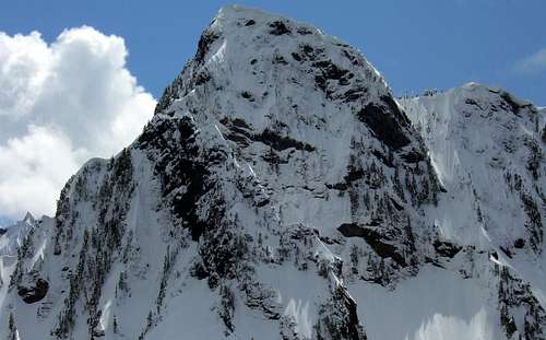
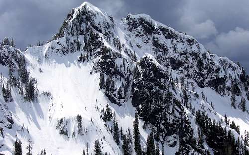
North Ridge and Northwest Face of Hall Peak from unnamed 4300' summit 0.7 miles N/NW of Hall Peak.
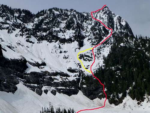
The Southeast Ridge route begins at the far west end of the Big Four ice caves snowfield. Start up the steep slope immediately to the right of the waterfall and cliffs - you should begin to notice flagging within a few minutes. There are numerous variations possible here, none of which are easy. Fortunately, there is plenty of vegetation to hang on to as you fight your way up this slope.
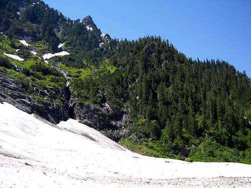
![Start of the Hall Peak brush bash]()
Start of Hall Peak route from end of Big Four Ice Caves trail
After topping out above and to the right of the waterfalls, you have a number of options. The published route makes a rising left traverse to the gully which descends from the Big Four/Hall saddle. In the spring this traverse is probably not too difficult, assuming you do not have to dodge things falling on you from above. In the summer, it is a nasty fight with the brush. We found the gully to be very unpleasant, with steep icy snow, deep moats, and thin snow bridges, followed by steep dirt and loose rock. Once topping out on the southeast ridge, the climb is fairly easy.
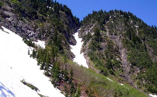
![Gully leading to Hall/Big Four saddle]()
Gully leading to Hall/Big Four saddle (not recommended)
Fortunately, there is a good alternative to using this gully. Once topping out above the waterfalls after the initial brush fight, you should find yourself in a small wash, which will be snow filled until June. You can follow this to its apex, which will almost intersect with the "alternative gully". Another option is to traverse left a few hundred feet into the gully/snowfield that feeds the waterfall, as this will turn into the "alternative gully". Snow conditions will probably dictate which choice is best. Once in the "alternative gully", follow it northwest. In early season, one could probably follow it to its apex - otherwise, follow the gully to 3600' - 3800', exit on the right hand side, and parallel the gully to its apex. From this point, straightforward climbing to the SW will bring you to the crest of the Southeast Ridge just south of Hall's summit.
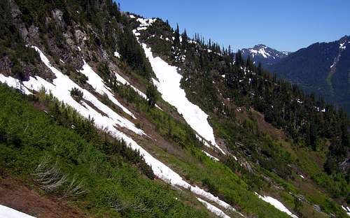
![Hall Peak descent route]()
Recommended gully for Hall Peak scramble
![Hall Peak climbing route]()
Recommended scramble routes for Hall Peak
![Hall Peak from Coal Creek Road]()
Hall Peak from Coal Creek Road. Red line shows the preferred scramble route to the summit.
Views from Hall's summit almost make the scratches and bruises worth it. Big Four is particularly imposing, and on weekends you can stare down at the throngs of people milling about at the ice caves 3500' below.
![Big Four from Hall Peak]()
Big Four from Hall Peak
![Hall Peak panorama]()
Hall Peak summit pano
Here is a photo of the "easy west ridge" for those who want to try from Silver Gulch. This route gets very brushy in late season.
![Hall Peak West Ridge and Pt. 5148]()
Hall Peak West Ridge and Pt. 5148
Start of Hall Peak route from end of Big Four Ice Caves trail
After topping out above and to the right of the waterfalls, you have a number of options. The published route makes a rising left traverse to the gully which descends from the Big Four/Hall saddle. In the spring this traverse is probably not too difficult, assuming you do not have to dodge things falling on you from above. In the summer, it is a nasty fight with the brush. We found the gully to be very unpleasant, with steep icy snow, deep moats, and thin snow bridges, followed by steep dirt and loose rock. Once topping out on the southeast ridge, the climb is fairly easy.
Gully leading to Hall/Big Four saddle (not recommended)
Fortunately, there is a good alternative to using this gully. Once topping out above the waterfalls after the initial brush fight, you should find yourself in a small wash, which will be snow filled until June. You can follow this to its apex, which will almost intersect with the "alternative gully". Another option is to traverse left a few hundred feet into the gully/snowfield that feeds the waterfall, as this will turn into the "alternative gully". Snow conditions will probably dictate which choice is best. Once in the "alternative gully", follow it northwest. In early season, one could probably follow it to its apex - otherwise, follow the gully to 3600' - 3800', exit on the right hand side, and parallel the gully to its apex. From this point, straightforward climbing to the SW will bring you to the crest of the Southeast Ridge just south of Hall's summit.
Recommended gully for Hall Peak scramble
Recommended scramble routes for Hall Peak
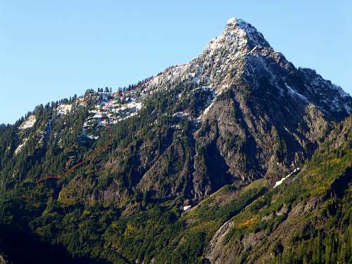
Hall Peak from Coal Creek Road. Red line shows the preferred scramble route to the summit.
Views from Hall's summit almost make the scratches and bruises worth it. Big Four is particularly imposing, and on weekends you can stare down at the throngs of people milling about at the ice caves 3500' below.
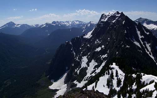
Big Four from Hall Peak
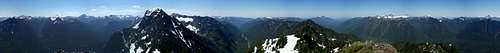
Hall Peak summit pano
Here is a photo of the "easy west ridge" for those who want to try from Silver Gulch. This route gets very brushy in late season.
Hall Peak West Ridge and Pt. 5148
Getting There
For the West Ridge route, take the Mountain Loop Highway east from Granite Falls, park at Silverton, cross the bridge over the river, and follow the trail (not marked) to Silver Gulch. Perhaps someone will be kind enough to post a full route description for the West Ridge here someday. I attempted this route in 2011 and found it to be particularly unpleasant.For the Southeast Ridge routes, continue east on the Mountain Loop Highway to the Big Four Ice Caves trailhead. The hike to the base of the mountain is a one mile stroll with virtually no elevation gain.
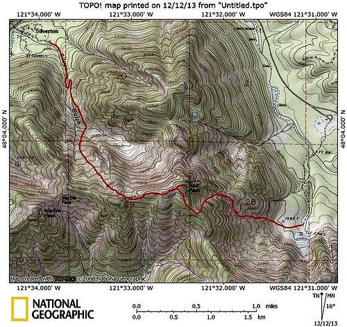
Hall Peak route map. I have also included the "easy West Ridge" route via Silver Gulch for those who would like to give it a try.
Note: On nwhikers.net, there are at least two trip reports describing a slightly different approach variation. With this routing, you break right off the Big Four Ice Caves trail shortly after crossing the Stillaguamish River, then intersect with the routing described on this page near the 3600' point. This route appears to have a slightly lower grade, but is probably a little more brushy in late season.