La montagna chiama i suoi figli, ed essi rispondono fedelmente al suo appello…
Osvaldo Cardellina, Diario alpinistico, 1964-65
Page texts: @ OsvaldoCardellina"Osva", passed away on May 2, 2022. Page owners: Christian Cardellina e Osvaldo Cardellina. Any updates from September 12, 2022: Antonio Giani, page administrator, friend and climbing companion.
Testi della pagina: @ OsvaldoCardellina "Osva", scomparso il 2 maggio 2022. Proprietari pagina:Christian Cardellina e Osvaldo Cardellina. Eventuali aggiornamenti dal 12 settembre 2022: Antonio Giani, amministratore della pagina, amico e compagno di salite.
Overview
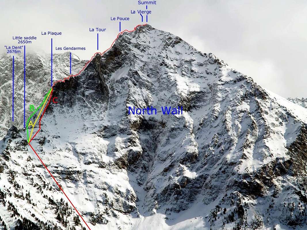
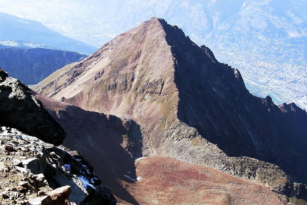
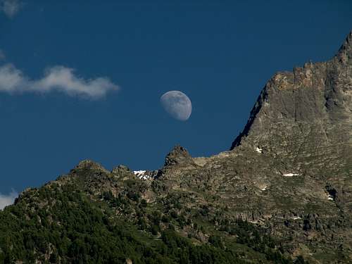
This tooth, well visible from all over the valley near the city of Aosta, rises on the watershed between the Vallone dello Arpisson Occidentale to the East or above the Municipality of Pollein and that of Morion further to the West which shares the border with that by Charvensod. Located at the base of the "Grande Plaque" of over 100 meters at the beginning of the North-northeast "Crestone" of Becca di Nona (3.142m) which is unquestionably the most beautiful route to the "Becca". The best among "Becca" routes, the Aosta town mountain for excellence. With this last Aerial ascent with middle-difficulty, by not always rock (dangerous likens black-greenish gneiss by wet rock not advisable). A passage more challenging the triangular plate (120m~) in initial part: three of ascent possibility. Good views to underlying Town of Aosta and to Emilius's North large Wall (3.559m). The ascent of the Dent de la Becca di Nona is not a destination in itself, but is complementary to the climb along the North-Northeast "Crestone"; as in the first ascent of the summer of 1967, it can be a diversion. Especially if you decide to bivouac at the base of the "Great Rocky Plate", as it happened on the occasion mentioned. The first climbers of the N-NE ridge avoided it on the right going up (West) coming from the Arpisson Valley. With 2.736 meters high, both according to the I.G.M. (Istituto Geografico Militare Italiano) that for the rare "MAP OF WALKS AND EXCURSIONS IN THE CONCA DI PILA - GRESSAN IN VALLE D'AOSTA NEW EDITION with Scale 1: 20.000 Published by the CENTRAL GEOGRAPHIC INSTITUTE - TURIN of 10 April 1973, shows in other maps geographic as the edition of L'Escursionista" sas Rimini. Italy 2007 "Valle di Cogne Map of trails 10 " wrong location with the toponym of" La Dent" as well as with the altitude of 2.998 meters, which actually corresponds to the" Grande Tour ". Always the same publishing house in the next edition of 2008 with the map "Conca di Aosta Pila - Monte Emilius Map of paths 4" corrects the positioning, while the altitude is identified at 2.672 meters, naming it as "Dent de la Becca", altitude then taken up in the photograph below by Antonio Giani with 2.676 meters. Other maps such as the "Carta hapax Comunità Montana Monte Emilius" also report the same error by placing "La Dent" in the place of the "Grande Tour" and then measuring it in 2.998 meters as in the following maps of June 2003 "Les sentiers de Charvensod" and, again like Hapax - Aosta 2010 in the "Charvensod Municipality map. Cartography Excursions territory Paths & nature of the Municipality ", 2nd edition and both with Scale 1:25.000.
Questo dente, bene in vista da tutto il fondovalle nei pressi della Città di Aosta, si eleva sullo spartiacque tra il Vallone dello Arpisson Occidentale ad Oriente ovvero al di sopra del Comune di Pollein e quello del Morion più ad Occidente che condivide il confine con quello di Charvensod. Situato alla base della "Grande Placca" di oltre 100 metri all'inizio del "Crestone" Nord-nordest della Becca di Nona (3.142 m) con quest'ultima che risulta indiscutibilmente essere la più bella via alla "Becca", montagna per antonomasia della Città di Aosta. Salita aerea e mediamente difficile su roccia non sempre troppo buona e con licheni nero-verdastri. Tratto molto impegnativo la placca triangolare di 120 metri circa che presenta tre possibilità di salita. Ottimo panorama sulla sottostante Città di Aosta nonché sulla vicina ed alquanto larga Parete Nord del Monte Emilius (3.559 m). La salita della Dent de la Becca di Nona non costituisce meta a se stante, ma é complementare alla scalata lungo il Crestone Nord-nordest; come nella prima salita dell'estate del 1967, può costituire un diversivo. Soprattutto se si decide di bivaccare alla base della "Grande Placca", nel modo in cui avvenne nell'occasione citata. I primi salitori della Cresta N-NE la evitarono sulla destra salendo (Ovest) arrivando dal Vallone dello Arpisson. Alto 2.736 metri, sia secondo lo I.G.M. (Istituto Geografico Militare Italiano) che per la rara "CARTA DELLE PASSEGGIATE ED ESCURSIONI NELLA CONCA DI PILA - GRESSAN IN VALLE D'AOSTA NUOVA EDIZIONE con Scala 1 : 20.000 Edita dallo ISTITUTO GEOGRAFICO CENTRALE - TORINO del 10 Aprile 1973, riporta in altre carte geografiche come l'edizione de L'Escursionista" sas Rimini. Italy 2007 "Valle di Cogne Carta dei sentieri 10" errata collocazione con il toponimo de "La Dent" nonché con l'altitudine di 2.998 metri, che in realtà corrisponde alla "Grande Tour". Sempre la stessa casa editrice nella successiva edizione del 2008 con la carta "Conca di Aosta Pila - Monte Emilius Carta dei sentieri 4" corregge il posizionamento, mentre la quota viene individuata in 2.672 metri denominando la medesima come "Dent de la Becca", altitudine poi ripresa nella sottostante fotografia ad opera di Antonio Giani con 2.676 metri. Anche altre carte come la "Carta hapax Comunità Montana Monte Emilius" riportano il medesimo errore collocando "La Dent" al posto della "Grande Tour" e quindi misurando la medesima in 2.998 metri come nelle successive carte del giugno 2003 "Les sentiers de Charvensod" e, sempre come Hapax- Aosta 2010 nella carta Comune di Charvensod Cartografia Escursionistica territorio Sentieri & natura del Comune", 2° edizione ed entrambe con Scala 1:25.000.
First Ascents
(A In simple ascent)
First Ascent from South little Face: Osvaldo Cardellina and Massimo Centelleghe, (Aug 03th, 1967, in day from Pila).
(B In crossing)
First traverse (from North to South): Ilario Antonio Garzotto and Osvaldo Cardellina, (Aug 24th, 1969, in day from Saint Salò-Gorres/Pila).
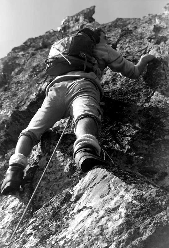
Climbing on highest (about 2.870/80 meters) amongst the "Gendarmes" after the ascent on La Dent de la Becca di Nona, photo by Massimo Centelleghe on August 1967
Getting There
BY CAR:
From Torino, Milano, etc: Motorway A5. Exit at Aosta Est. From Switzerland: through the Grand Saint Bernard Tunnel or the namesake Pass. From France: through Mont Blanc Tunnel or Petit Saint Bernard Pass. It isn't necessary to take Motorway A5: you can drive on SS.26, in the direction of Aosta.
BY PLANE:
Aeroporto Internazionale "Corrado Gex"; Saint Christophe (Aosta).
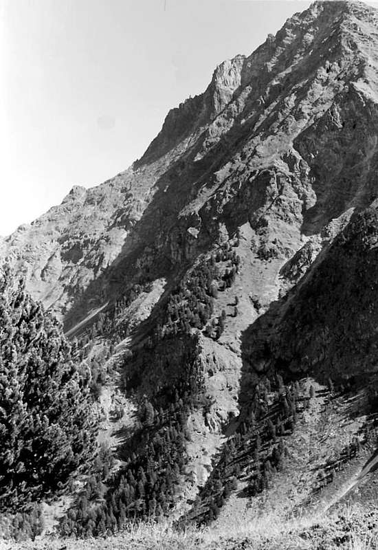
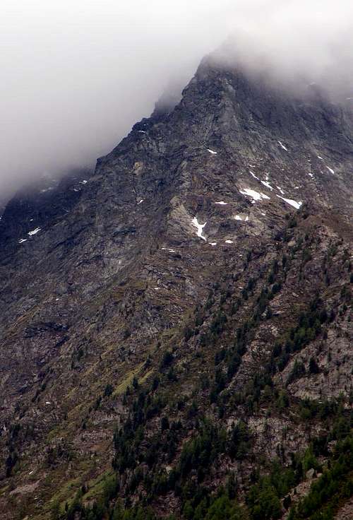
From West approach to LA DENT de la BECCA di NONA, by Osw, on the Morion Vallon below and at the beggining of N-NE "Crestone".
Approaches to Arpisson / Morion watershed
1)- From Chamolè station of chairlift (2.311m) by path 19c 19 to Chamolè Lake (2.325m), North Replan Pass (2.366m), Comboè "Lower" (2.601m), path to Morion Alp (1.949m; ruins), West Slope of Becca Jag (2.736m) and little saddle (2.650m), (3h'30/4h'00).
2)- From Pila - Saint Laurent (1.800m) or from parking (1.841m) to Chamolè Alp (2.152m), Plan Fenêtre Pass (2.221m), "Lower" Comboè little Valley (2.001m) joint to preceding route (4h'00).
3)- From main route (regional road) to Pila Tourist Station in quota 1.000m~ to Saint Salò-Gorres (1.382m) little Villages and by path 14d to Ponteills Alp (1.697m) and Waterfall (1.800m~) joint the previous route at entry (2.001m) Comboè Valley (3h'30/4h'00).
4)- From main road to Pila, crossroads to Reverier in quota 1.000m~ toward Reverier to Tzat and Lower (1.042m), Ronghachet Bridge and Alp (1.113m), Barmes Alp (1.255m), Martsaouchy Middle and Higher (1.416m); from Higher by path to Plan Croix Alp 1.744m; ruins), Arpisson Lower (1.951m) and Higher (2.010m) and through Eastern Slope of NE Spur (4h'00/4h'30).
5)- From Higher Martsaouchy (1.416m) by path to Plan Croix Alp 1.744m and from quota 1.900m~ direct ascent through wood, grassy slopes and little rocks, crossing in right (W) of "La Dent" (2h'00/2h'30).
1)- Dalla Stazione della Seggiovia di Chamolè (2.311 m) con i sentieri 19c e 19 per il Lago di Chamolè (2.325 m), il Col Replan Nord (2.366 m), Comboè "Basso" (2.601 m), sentiero per Alpe Morion (1.948 m; rovine) e per il versante Ovest de "La Dent" (2.736 m) e la piccola Sella 2.650 metri circa (3h'30/4h'00).
2)- Da Pila - S. Lorenzo (1.800 m) o dal parcheggio (1.841 m) all'Alpe di Chamolè (2.152 m), Colle Plan Fenêtre (2.221 m), Comboè "Basso" (2.001 m) ricongiungendosi alla via precedente (4h'00).
3)- Dalla Strada Regionale per Pila a quota 1.000 m circa verso i piccoli Villaggi di Saint Salò e Gorres (1.382 m) e con il sentiero 14d per l'Alpe (1.697 m) e la Cascata (1.800 m circa) di Ponteilles ricongiugendosi alle vie precedenti, all'ingresso del Vallone di Comboè (3h'30/4h'00).
4) - Dalla Strada Regionale per Pila, bivio per Reverier Dessous a quota 1.000 m circa, a Reverier du Tzat, Reveriers Dessous o Desot (1.042 m circa), Ponte e Alpe di Rongachet (1.113 m), Alpe di Barme (1.255 m), Martsaouchy e Martsaouchy Damon (1.416 m); da Martsaouchy con sentiero per l'Alpe diroccata di Plan Croix (1.744 m), Arpisson di Sotto (1.951 m) e di Sopra (2010 m) e per il versante orientale del Contrafforte NE (4h'00/4h'30).
5) - Da Martsaouchy Damon (1.416 m) con il sentiero per Plan Croix (1.744 m) e dalla quota 1.900 metri circa direttamente tramite il bosco, pendii erbosi e roccette, passando a destra de "La Dent" (2h'00/2h'30).
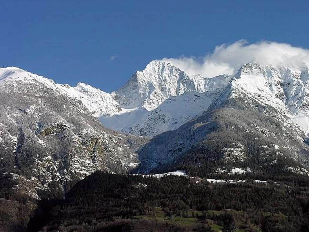
APPROACHES to North-northeast Rige: from Marstaouchy Tableland (snowy), true front door to Arpisson wild Valley, below the North Wall of Mount Emilius (left); in right (West) the Morion rocky promontory, obliged passage for the aprroaches from Dard deep Valley or Ponteilles Waterfall and fron Pila-Resort through the Plan Fenêtre Hill.
Two Routes
(A In simple ascent)
Reached the small and enough large and sinous Saddle 2.650 meters approximately via the Western Slope of the Morion/Arpisson watershed (see the various approaches), all that remains is to climb the short and easy South Crest of La Dent della Becca di Nona reaching the Summit of the same after having overcome some small roughness formed from elementary little rocks.
Raggiunta la piccola nonché abbastanza larga e sinuosa Sella 2.650 metri circa tramite il Versante Occidentale dello spartiacque Morion/Arpisson (vedi gli avvicinamenti varii) non rimane che salire la breve e facile Cresta Sud de La Dent della Becca di Nona raggiungendo la Sommità della medesima dopo avere superato alcune piccole asperità formate da roccette elementari (F+/I°; 0h'15).
(B In crossing)
About fifty meters before reaching the small and rounded Sella 2.645/50 meters approximately via the Western Slope of the Morion/Arpisson watershed ,(always see the various approaches), bend slightly left avoiding the Western Face of la Dent to reach the tiny Northern Saddle (2.630 meters approximately) located between the two "Camel humps" in the North (2.586 meters for the edition of "L'Escursionista" sas Rimini. Italy 2008 with the map "Conca di Aosta Pila - Monte Emilius Map of paths 4 ") and the La Dent climb the short and easy South Crest of La Dent della Becca di Nona. Turning to the South, first go up a tiny rocky step followed by a more evident next (F/ F+/I°/II°-); once you have reached a more marked ledge, tackle the terminal jump by crossing it directly on the edge (AD/AD-/III°/III°-) or resting on the easier rocks on the right (West, PD +/II°/II°+). After passing the not always easy Northern Crest of La Dent della Becca di Nona reaching the Summit of the same, you descend to the Sella approximately 2.650 meters via the previous basic itinerary or the short Southern Crest at the base of the "Great Rocky Plate". This brief climb is not difficult but requires some caution, given the exposure especially from the Eastern Face or the Arpisson, not being trivial even on the Morion Side (F+/PD-/PD/AD/AD-/I°/II°/II°+/III°/III°-; 0h'35/0h'45).
Una cinquantina di metri prima di raggiungere la piccola ed arrotondata Sella 2.645/50 metri circa tramite il Versante Occidentale dello spartiacque Morion/Arpisson (vedi sempre gli avvicinamenti varii) piegare leggermente sulla sinistra salendo così evitando il Versante Occidentale de la Dent per pervenire alla minuscolo Sella Settentrionale (2.630 metri circa) collocata tra le due "Gobbe di Cammello" a Settentrione (2.586 metri per l'edizione de L'Escursionista" sas Rimini. Italy 2008 con la carta "Conca di Aosta Pila - Monte Emilius Carta dei sentieri 4") e la Dent stessa. Volgendo a Meridione, dapprima salire lun minuscolo gradino roccioso seguito da un successivo in maggiore evidenza (F/F+/I°/II°-); raggiunta una marcata cengia affrontare il salto terminale superando direttamente sul filo il medesimo (AD-/III°-) oppure appoggiandosi sulle rocce più facili a destra (Ovest, PD+/II°/II°+). Superata la non sempre facile Cresta Settentrionale de La Dent della Becca di Nona raggiungendo la Sommità della medesima, si scende alla Sella 2.650 metri circa tramite il precedente itinerario di base ovvero la corta Crestina Meridionale alla base della "Grande Placca". Questa breve salita non è difficile ma richiede una certa prudenza, vista l'esposizione soprattutto dal lato Orientale o dello Arpisson non risultando banale pure sul versante del Morion (F+/PD-/PD/AD/AD-/I°/II°/II°+/III°/III°-; 0h'35/0h'45).
When to Climb
When to Climb: from the end of Spring just to the middle Autumn.
Quando scalare:dalla fine della Primavera fino al mezzo Autunno.
Campings
Remember that free camping is forbidden (except for emergency reasons, over 2.500m, from darkness until dawn).
Mountain Condition
Meteo: you can find all the needed informations at the official site of the Valle d'Aosta Region:
"Guida del Monte Emilius", di Osvaldo Cardellina Editore in collaborazione con il Club Alpino Italiano Sezione di Aosta, Dicembre 1978.
"Guida dei Monti d'Italia – Emilius Rosa dei Banchi Parco del Mont Avic" di Giulio Berutto e Lino Fornelli - Club Alpino Italiano/Touring Club Italiano, Marzo 2005.
"Guida delle Alpi Occidentali" di Giovanni Bobba e Luigi Vaccarone C.A.I. Sezione di Torino Volume II (parte II), 25 Maggio 1896.
"80 itinerari di Escursionismo Alpinismo e Sci Alpinismo in Valle d'Aosta", di Osvaldo Cardellina, Ed. Musumeci, Giugno 1977 (in Italian); seconda Ed. Luglio 1981; terza Ed. Luglio 1984; (in French), prima Ed. Febbraio 1978; seconda Ed. Marzo 1980.
"Diari Alpinistici" di Osvaldo Cardellina e Indice Generale accompagnato da Schedario Relazioni Ascensioni 1964-2019 (inediti).
MAPS:
Kompass "Gran Paradiso Valle d'Aosta Sentieri e Rifugi" Carta turistica 1:50.000.
L'Escursionista "Conca di Aosta-Pila-Monte Emilius" Carta dei sentieri (n° 4) 1:25.000.
Hapax "Les Sentiers Comunità Montana Monte Emilius", Luglio 2000 1:25.000.
Enrico Editore Ivrea-Aosta "Gruppo del Gran Paradiso" 1:50.000.
I.G.C. Istituto Geografico Centrale, Torino "Carta delle Passeggiate ed Escursioni in V.D.A. Conca di Pila-Gressan, 1:20.000.
Parents refers to a larger category under which an object falls. For example, theAconcagua mountain page has the 'Aconcagua Group' and the 'Seven Summits' asparents and is a parent itself to many routes, photos, and Trip Reports.


 1053 Hits
 81.84% Score
 14 Votes