


-
 10158 Hits
-
 89.39% Score
-
 29 Votes
|
|
Mountain/Rock |
|---|---|
|
|
45.70090°N / 7.34196°E |
|
|
Charvensod Municipality (Punta della Valletta Subgroup) |
|
|
Mountaineering |
|
|
6670 ft / 2033 m |
|
|
Note
|
La montagna chiama i suoi figli, ed essi rispondono fedelmente al suo appello… Osvaldo Cardellina, Diario alpinistico, 1964-65 Page texts: @ OsvaldoCardellina "Osva", passed away on May 2, 2022. Page owners: Christian Cardellina e Osvaldo Cardellina. Any updates from September 12, 2022: Antonio Giani, page administrator, friend and climbing companion. Testi della pagina: @ OsvaldoCardellina "Osva", scomparso il 2 maggio 2022. Proprietari pagina: Christian Cardellina e Osvaldo Cardellina. Eventuali aggiornamenti dal 12 settembre 2022: Antonio Giani, amministratore della pagina, amico e compagno di salite. |
OVERVIEW
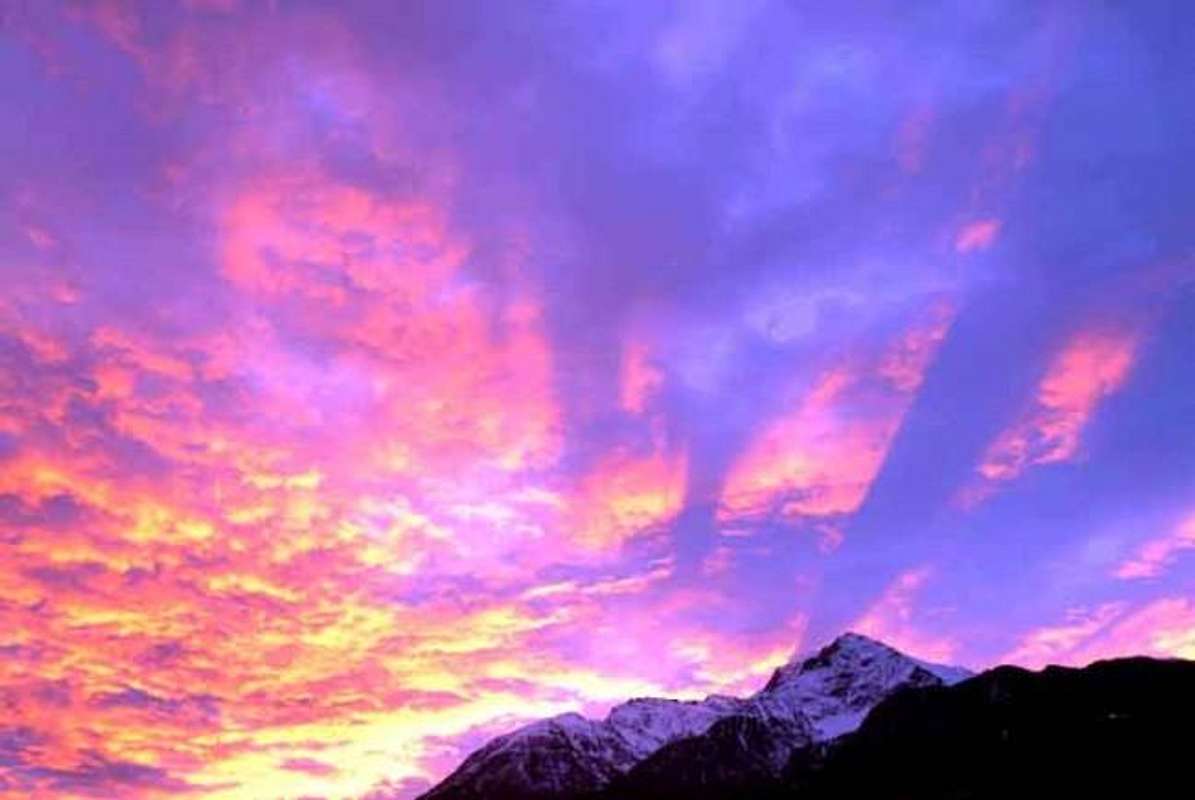
Everybody believes that my preferred point is the Becca of Nona, that I have climbed about eighty times or the Emilius on the top of which I have had the honor to sojourn and to place the foot for over fifty or, even, the Garin, the Red Point of the Emilius, the of Valletta Point, the Leppe Point or the Black Head; or on the other side of the Dora Baltea the Becca of Viou and the Mount Fallère, tops where I have consumed the boots to strength to go you. Instead no: the point, among the climbed thousand, from me you favor it is the Point of the Dard that dangles above the roof of my house and from the sources of which The drinks every day of it the fresh waters and cleaning up. Hardly more in there, unsociable for this turnaround of mine, they are the "Becca" that the Emilius covers making to see a least of it "slice"; instead the Point of the Dard is really there above and in flood it approves and, when I open the window to the morning, it appears in all of its green very fascinating livery. They are also this way to her lover because so I have baptized her in the distant 1978 when I wrote "Guide of the Emilius Mountain" freeing it from an unfair anonymity, because until then it was it Mrs. Quota 2.033 meters, to everybody unknown.
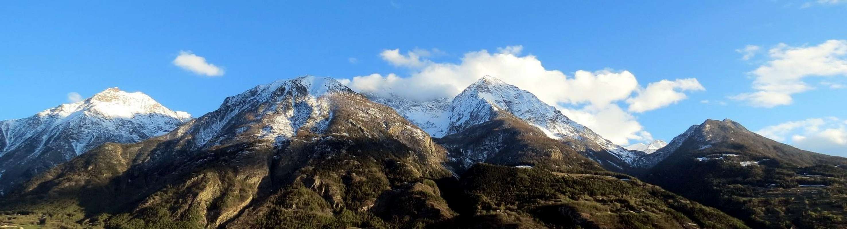 |
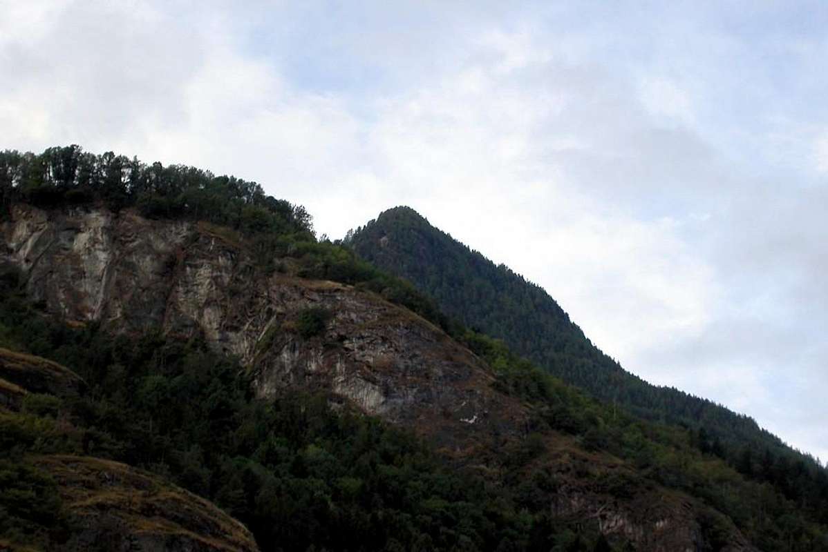
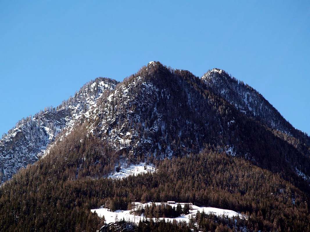
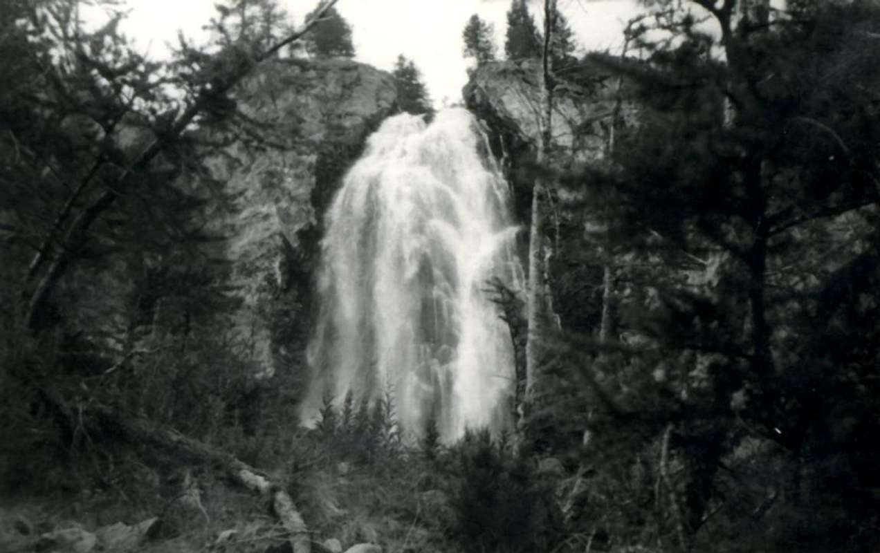
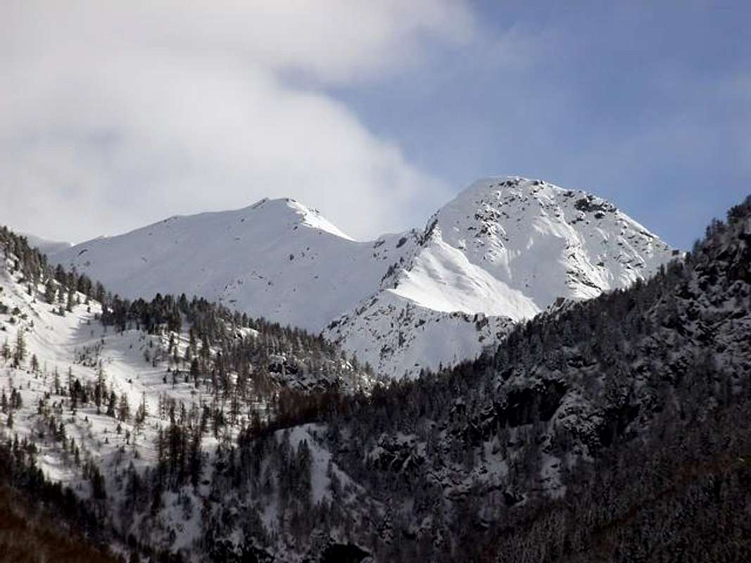
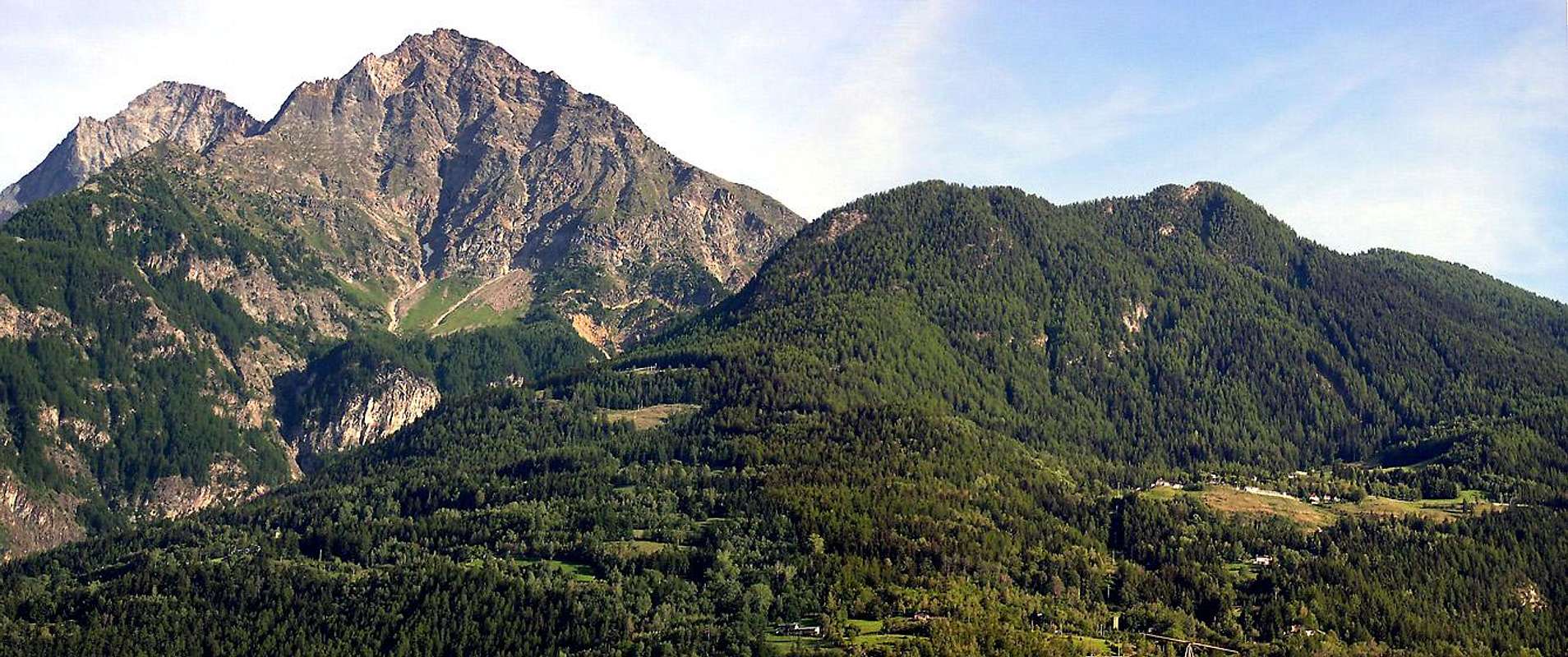
But perhaps anciently and for the inhabitants of Charvensod the point already possessed a toponym as from "33 ROUTES OF MONTE EMILIUS" as from SP, Part A, Sector 2: "f) - Punta of the also Pointe du Dard or Pecks also "Becca" at of R(i)en ("Worthless Point" of "nothing" other - wise of "copper?" or "Copper's Point", in the presence of Ancient Coppermine)" And nowadays and here we add: "Or Stings of Nothing, that is petty (especially in comparison to the neighbors and mastodontic he Pecks at and Emilius); but another version is advanced by the ex Mayor of Charvensod Eusèbe Imperial and that is; "he doesn't Peck at de Ren, that means Nothing in dialect, but he Pecks at de Rem and therefore of the Copper, since from the tradition it would seem that they extracted this mineral in a place to locate in the small vallon inside the Black Forest of Combatissière and very probably between the Point of the Dard and the Point Valletta"… What as we will see and we will read to the Route D), was used once for the sheep farming and for the transport of the livestock. And therefore, and besides, always from the Primary-School Teacher Eusèbe: "But the everything is to verify, also because nowadays the ground become uncultivated results to a large extent covered by the sharp pain brushwood and from the vegetation"... Hoping that then some young of good wish patiently goes to verify facing the busillis, loosening the terrible ENIGMA, that doesn't allow us to sleep, and bringing to us with sum abundance and accurately in detail the rhesus final account. It is not that after sometime is mostly become It, also because it is a timid Girl and rather reserved, that doesn't love very the intrusions of the crowds and being chaste Miss loves to grant only him to few reserved and carefully select. We am among those people. Situated at the end of the long crest watershed, dividing aloft the Vallon of Arbolle from that of the Plan de the Eyve, in mean that of the Comboé from the Basin of Pila and in low that from which he takes name from the splendid Black Forest of Combatissière to East of the Hermitage of Saint Grat, it is small top of the long buttress that comes down toward North from the Valletta's Point (3.090m), the originated and mother point. Its wooded and rocky layers fall uphill streets toward East above the homonym vallon and the notorious Torrent de Comboé, while to North they decay above the tall Alps of Les Pouces, Les Lezières, Combatissière in the Commune of Charvensod, taking the distances with sum reservation from the City of Aosta that, well as everybody knows, it is the town of the Emilius and of the "Becca". Ours is dark instead small Country and it looks well at dib belong to the élite. Toward Midday a slender path the league to the Point Valletta and to the Point of Ponteilles, near the Hill Plan Fenetre, true mouth of entry to the Vallon of the Comboé, that an ample rocky slope, fractured in his mean by the Fall of Ponteilles, it divides from the underlying one for the note of the Dard. The same is situated to the most elevated extremity and it is not to confuse with the underlying Fall of Chenaux, Fraction of Pollein 's Municipality, at the end of the same narrow valley, where a Gym of Rock S.M.A exists. (Military School Alpine) enough frequented by the climbers up to the year 2000 in which the Great Flood was verified, such to cause seven corpses in this solo village. The works of restructuring and prevention with cementing, subsequently effect, they have in practice disabled the access to the same one, for which thing today results entirely almost abandoned. Beautiful unusual sights, and to few reserved, on big part of the Northern sector of the Valley of Aosta and on his principal bourg.
 |
Tutti credon che la mia punta preferita sia la Becca di Nona, che ho salito un'ottantina di volte, oppure l'Emilius sulla Cima del quale ho avuto l'onore di soggiornare e posare il piede per oltre cinquanta o, magari, la Garin, la Punta Rossa dell'Emilius, la Valletta, la Leppe o la Testa Nera; oppure dall'altra parte della Dora Baltea la Becca di Viou ed il Mont Fallère, cime ove ho consumato gli scarponi a forza di andarvi. Incece no: la punta, tra le migliaia salite, da me prediletta è la Punta del Dard, che penzola sopra il tetto di casa mia e dalle sorgenti della quale ne bevo tutti i giorni le acque fresche e pulite. Appena più in là, scontrosi per questo mio voltafaccia, stanno la Becca, che copre l'Emilius facendomene vedere una minima "fetta"; invece la Punta del Dard è proprio lì sopra ed in piena vista e, quando apro al mattino la finestra, si mostra in tutta la sua verde livrea molto affascinante. Così sono a lei affezionato, anche perché così l'ho battezzata nel lontano 1978 allorché scrissi "Guida del Monte Emilius" liberandola da un ingiusto anonimato, perché insino ad allor era la Signora Quota 2.033 metri, a tutti sconosciuta. Ma forse anticamente e per gli abitanti di Charvensod la punta possedeva già un toponimo come da "33 ROUTES OF MONTE EMILIUS" come da SP, Part A, Settore 2: "f) - Punta del also Pointe du Dard or Becca di R(i)en (= "Worthless Point" of "nothing" other - wise of "copper"? = "Copper's Point", in the presence of Ancient Coppermine)" Ed oggidì e quivi aggiungiamo: "Ovvero Punta di Niente, cioè di scarsa importanza (soprattutto in confronto alle viciniore e mastodontiche Becca ed Emilius); ma un'altra versione viene avanzata dall'ex Sindaco di Charvensod Eusèbe Imperial e cioè; "Non Becca de Ren", che in dialetto significa Nulla, ma Becca de Rem e quindi del Rame, poiché dalla tradizione sembrerebbe che estraessero questo minerale in un posto da localizzare nel valloncello all'interno della Foresta Nera di Combatissière e molto probabilmente tra la Punta del Dard e la Punta Valletta" … Che come vedremo e leggeremo alla Via D), sperando che poi qualche giovane di buona volontà vada pazientemente a verificare, una volta veniva utilizzato per la pastorizia e per il trasporto del bestiame. E quindi, ed inoltre, sempre dal Maestro Elementare Eusèbe: "Ma il tutto è da verificare, anche perché oggigiorno il terreno diventato incolto risulta in gran parte ricoperto e mangiato dalla fitta boscaglia e dalla vegetazione"... Sperando che poi qualche giovane di buona volontà vada pazientemente a verificare affrontando il busillis, sciogliendo il terribil ENIGMA, che non ci permette il sonno, e riportandoci con somma dovizia e dettagliatamente il reso conto finale. Non è che con il passare del tempo lo sia divenuta maggiormente, anche perché è una Signorina timida ed alquanto reservé, che non ama molto le intrusioni delle frotte ed, essendo Ragazza pudica, ama concedersi solo a pochi riservati ed accuratamente scelti. Noi siamo tra coloro. Situata al termine della lunga cresta spartiacque, divisoria in alto il Vallone di Arbolle da quello del Plan de l'Eyve (Pianoro dell'Acqua), in mezzo quello del Comboé dalla Conca di Pila e dabbasso quello dal quale prende nome dalla splendida Foresta Nera di Combatissière ad Oriente dell'Eremo di San Grato, è piccola cima del lungo contrafforte che discende verso Settentrione dalla Punta della Valletta (3.090 m), punta madre originante. Le sue propaggini boschive e rocciose precipitan erte verso Est sopra l'omonimo vallone ed il famigerato Torrent de Comboé, mentre a Settentrione decadono sopra gli alti Alpeggi di Les Pouces, Les Lezières, Combatissière nel Comune di Charvensod, prendendo le distanze con somma riservatezza dalla Città di Aosta che, come tutti bene sanno, è la città dell'Emilius e della Becca. La nostra è invece più contadinella e se ne guarda bene di far parte dell'élite. Verso Mezzogiorno un esile sentiero la lega alla Punta Valletta ed alla Punta di Ponteilles, presso il Colle Plan Fenêtre, vera bocca d'ingresso al Vallone del Comboé, che un ampio spalto roccioso, fratturato ed inciso nel suo mezzo dalla Cascata di Ponteilles, divide dal sottostante per l'appunto del Dard. La stessa é situata all'estremità più elevata e non é da confondere con la sottostante Cascata di Chenaux, Frazione del Comune di Pollein, al termine del vallone medesimo, dove esiste una Palestra di Roccia S.M.A. (Scuola Militare Alpina) abbastanza frequentata dagli arrampicatori fino all'anno 2000 nel quale si verificò la Grande Alluvione, tale da causare sette morti in questo solo villaggio. Le opere di ristrutturazione e di prevenzione con cementificazione, effettuate successivamente, hanno in pratica disabilitato l'accesso alla stessa, per la quale cosa oggi risulta quasi del tutto abbandonata. Belle viste inconsuete, ed a pochi riservate, su gran parte del settore Settentrionale della Valle d'Aosta e sulla sua principale città.
 |
 |
FIRST ASCENTS
- First on the summit: Unknown.
- In Winter: Ilario Antonio Garzotto, Dario Sergio Cardellina and Osvaldo Cardellina, Apr 11th, 1966, in day from Pian Felina Village to Reveriers Alps and Ponteilles's Waterfall.
- Directly through Eastern Slope: Ilario Antonio Garzotto, Dario Sergio Cardellina and Osvaldo Cardellina, Apr 11th, 1966, in day from Pian Felina Village, Reverier Desot and Damon.
- Directly by Northerly Face: Emilio Bertona and Osvaldo Cardellina, Jul 06th, 2005, from Pila Low Station of Cable-Way, Hermitage of Saint Grat and Combatissière's-Les Pousses Alps.
 |
 |
 |
 |
 |
GETTING THERE
BY CAR:- From Torino, Milano, etc: Motorway A5. Exit at Aosta Est. From Switzerland: through the Grand Saint Bernard Tunnel or the namesake Pass. From France: through Mont Blanc Tunnel or Petit Saint Bernard Pass. It isn't necessary to take Motorway A5: you can drive on SS.26, in the direction of Aosta.
BY PLANE:
- Aeroporto "Corrado Gex"; Saint Christophe (Aosta).
 |
APPROACHES
APPROACHES by the Chamolès Alp and through the Plan Fenetre Pass with descent to Comboé's Vallon, Low Comboé to of Ponteilles Wateerfall and fork 1.612 meters
1) - From Pila-Pilaz/Restaurant Lion Noir (1.815m around), Pilaz Pasture (1.840m around) and, through the path n° 16, to fork 2.099m, with the traverse path n° 14/19A/19. from Gorraz Dèsot (= Lower); therefore, by the commune paths n° 14/16/19/19A, to Chanté Pasture (2.114m; now exclusively remains), Chamolé's Prairies and Alp (2.152m; not to cross but obligatorily to edge by) and with the following path, n° 16/20A toward the fork 2.190m about (with the path from Saint Grat Hermitage and Pasture), Plan Fenêtre Pass (2.229/34m), descent to Comboé Pastures (2.114m; little chapel), Comboé Dessous (2.041m), fork 1.975m around (wooden cross; from the "Vallone" of Dard and relative Ponteilles Pasture and Waterfall) toward Morion Old Pasture (1.948/52m. To abandon on the right (East) this deviation and to go down with the beautiful path formed from small hairpin bends, instead the promontory-slope, along the parallel path to the course of the Torrent de Comboé and to the Waterfall of Ponteilles among the 2.000/1.750 meters reaching with to brief diagonal ending the homonym Alpe (1.706m); from this, through the dirt road "poderale" to still go down to brief line up to the intersection 1.612 meters, where, near the torrent, the same one intersects the paths n° 14D, coming from Les Pousses also called Pouce and n° 14 that salt from the floor valley (E; 2h'00/2h'15).
 |
2) - From Pila, Parking lot near Pesein to 1.865m around with the path, triplexly numbered 14/19A, with slope to the overhanging and recently restructured Alp of Gorraz Désot (1.930m) and, with direction passing below the Chair lift Northeast for Chamolé Loch near the pylon n° 10 of the same, through the Bois Jardin Public (Wood of the Public Garden) to reach at first the alternative 2049m and immediately after the fork 2.099m, connecting again itself to the street of approach precedent (E; 2h'00).
APPROACH passing Saint Grat Hermitage and omonym pasture, Chamolé's Alp and by the with same name lake and through Plan Fenetre Pass.
3) - From Pila - Saint Laurent (1.800m) or from parking (1.841m), Hotel Lion Noir, dirt road/path n° 14L to Saint Grat Hermitage (1.787m; fountain and pic-nic wooden area) and through the dirt "poderale" starting just before the Sanctuary to Upper omonym pasture (1.835m around; fountain) to Chamolè's Alp (2.152m) and through the path n° 16/20A toward Plan Fenêtre Pass (2.221m), "Lower" Comboè little Valley (2.001m) joint to preceding route (E; 2h'15). More direct APPROACH passing from the Hermitage and from the Alp of Saint Grat, dirt road "poderale" of the Forest Rangers, alternative 2.140m and Hill Plan Fenetre.
 |
 |
 |
 |
 |
4) - From the Sanctuary and of Saint Grat Pasture through the "poderale" to overcome the first winding road toward right and to reach a second of it; from this crossroads he abandons another dirt road "poderale" that goes down to the Alps of Combatissière (1.750m; in the grassland two very beautiful "rascards" in wood to visit him) to continue with other two windings and, after a brief rectilinear line, to reach an alternative. From this toward right it continues the road toward the Alp of Chamolé, while in opposite sense (East-northeast) it begins to said similar poderale of the "Forest Body" that reaches alternative the 1.983 meters; from this the aforesaid poderale is undoubled sending to Southwest deviation that again connects him to that original of departure to quota 1.953 meters and another ramification toward East-northeast, that flows, subsequently, in to small path addressed at first toward the Valletta Point (2.164m) and then, with wide turn to South, it reaches the Hill Plan Fenêtre. Don't use two anybody, on the contrary from the alternative 1.983 meters to take a path/mule-track not numbered that, with narrow and rather steep hairpin bends, reaches to the intersection 2.140 meters the path n° 20 coming from the Alp of Chamolé and, through this, to reach the hill connecting again itself to the preceding approach (E; a quarter of now in less, but well more fatiguing). APPROACHES VARIAOUS, for the starts I mediate tall and forced passage through Pousses Alp, also by the Rongachet's Bridge and the water intake of La Mare resort for departures middle low, always passing along and through the Dard's Vallon, Alp and Waterfall of Ponteilles at the entrance into Low Valley of Comboé, near the fork 1975m around.
5) - Departures from the part I mediate tall of the Regional Road for Pila to quota 1.000m~:
a) -, b) -, c) -, d) -, e) -, f) -, g) -, h) - From and toward:
a) - the Saint Saloo also called Salò Village (1.307m) and with concomitant path with the dirt road "poderale" for Les Gorres in the first line and then with autonomous path n° 14E that, passing to South of the village and again crossed the "poderale" toward East-southeast, it goes to join around himself to quota 1.480 meters about with the path n° 14D, coming from few above the Fraction of Chateau-Charvensod (823m), passing into Bondine's Village (1.043m);
b) - Les Gorres Village (1.385m), through the preceding route; or from the alternative 1.332 meters on the road of Pila with deviation to the left (descriptive poster and of prohibition of transit with auto) reaching on dirt road "poderale" the village. Same give to continue Southeast with the path n° 14E and then to reach the alternative 1.500 meters around, as soon as before the Alp Les Leyzères (1.517m); from this to rejoin him, through brief slope of connection, to the precedent path n° 14D and to reach Les Pousses Pasture (1.601m), to the entry of the "Vallone" of the Dard (Valley of the Waterfall).
c) - with departure from the Village of Le Champex (1.290m; attainable after two elbow windings road on the road for Pila and with a brief line of dirt "poderale") to go himself with the path n° 2, coming from Reverier Dessus (1.124m), toward West actually to reach the path n° 14D as soon as above the same one and with this to continue toward Les Pousses Pasture (1.601m), to the entry of the Valley of the Dard and underlying the homonym point (2.033m).
d) - Les Pousses attainable also through the dirt road "poderale" that from Les Gorres Village, with very wide turn toward Southwest it touches the Alp of Le Vaccoz (1.469m) for then to reenter toward East-northeast;
*e) - Even from Pila: or with the path n° 14L that, even beginning from Pila, it passes for the Hermitage of Saint Grat, it goes down to the Combatissière's Pastures (1.750m; splendid "rascards"), Les Usellières (1.566m), Vaccoz and from these passing under and in parallel to the road poderale) through the continuation of the dirt road or with the path n° 14L, described hardly above, to reach Les Pousses Pasture (1.601m) to the intersection with the path n° 14D, as soon as over the long stall.
f) - beginning from the Alp Les Leyzères (attainable from the path n° 14E that salt from the alternative among the two small Villages of Les Carnières (1.180m) and La Pissine Salà (1.307m); or with the long path n° 14L that, departing from Pila-Hermitage of St. Grat, it entirely crosses the Black Forest of Combattissière), through the continuation of this last toward East or on the impending and parallel dirt "poderale", to reach shortly Les Pousses Alp.
g) - with departure from Les Pousses oppure Pouce (1.601m), at the beginning of Dard's Valley, through the path n° 14D, along a diagonal to South and near the old brook for irrigation, arriving to Comboé Torrent in quota 1.670m around; and, after forded across on the same and crossed the dirt road, reach the Ponteilles (1.706m) Pastures.
** h) - Variant: even through the below dirt road "poderale", fording twice the Comboé Stream reach the alp. From Alp, through a more steep slope side by side in East with the Waterfall (1.750m around).
6) - From the floor valley between the Fractions Pont Suaz, Pian Felina, High Felina, Roula(z) (Charvensod's Municipality) and Chenaux, Chenières (Commune of Pollein):
i) -, l) -, m) -, n) - from the little Fractions and Villages toward:
i) - with beginning from the Fraction of the Pont Suaz (567m), near the homonym bridge on Baltea Dora Stream it to the doors of Aosta, immediately to depart from the alternative behind the little church and to leave the Regional Road for Pila on the right; to take to the left instead that in asphalt and direct toward South. When this, concomitant with the path n° 14D/intervalleys n° 102 (what it crosses the GROUPs of the Mount Emilius, Point Tersiva and Mount Glacier reaching the lakes of Champdepraz) develops on the left (East), to abandon it; to continue through the aforesaid path and on the fund of a small "vallone" reaching Charvensod, situated on the hill in south of the Aosta's Town, between the places of Les Condemines and Le Chateau (820/3m). From the Chief town, abandoning to the right (South) the aforesaid path that is addressed to Peroulaz Fraction (1.359m), to go up again instead Southeast the impending hill through the path 14L that, through the wood and meadow lines, it reaches first the dirt road "poderale" and then the inhabited area of Bondine (1.043m; beautiful fountain in stone in the small place of the center village); from this to continue, same direction and same path, reaching the overhanging Village of Les Carnières (1.180m). Left the alternative to South, with path n° 14E, addressed to La Pessina Sala(à) and Les Gorres (1.307m, 1.385m), to continue instead with 14D and, crossed the Regional Road to quota 1.260 meters, actually to the alternative 1.460 meters, impending this last pasture. From this point to continue with the approaches under described to Les Pousses (1.601m).
l) - from the Village of Pian Felina also called Plan Félinaz (565/68m), with the path n° 14 that it passes to the superior Fraction of Felina (588m) to join himself with that coming from that of Roula(z) (835m around), with numeration 14 again, and in quota 835m around for then to reach at first the dirt road "poderale" for the Village of Le Pointier (976m) and immediately after the same and connecting itself to the Village of Reverier du Tzat passing between woods and meadow expanses (you see more before the Approach h) -.
 |
"Old" Approach for the ascent in day from the floor valley: the old path (that historical of the ascension to the Wall North in '66), that, departing from Pian Felina fraction passed from the Fraction Le Créton (609m), it crossed the old path Felina among Tall and the Municipality of Charvensod ("The Path of the Corpses", because the dead ones of the floor valley were transported to shoulders to the Chief town), reaching the first one and the second winding road toward East on the Regional Road for Pila it doesn't exist anymore, because "swallowed" from the vegetation). The same, continued subsequently toward the sundry Villages of Reverier (of Cat, Lower and Upper), with some approaches today used still and here described, for then to insert him in the "Vallone" of the Dard following the line of slope dictated by the Comboé Torrent.
m) - from Chenaux Village (600m about about) also from these of Chenières (613m) e Cretes (591m), above the hill just under the Chief town. With departure directed by the Village of Chenaux with the path n° 2 or indirect, through the small road asphalted town, from the adjoining Fractions of Chenières and Cretes. From the first village the path immediately departs behind the small Church of St. Lawrence near the new town road in asphalt and open to the traffic, that salt on the traces of the old sporting plant of the traditional sled or "ludge", reaching Terre Blanche Dessous (White Earths of Under; 1.015m), the alternative 1.050 meters around under the Alp Gorettaz (1.089m), the small Village of Rongachet (1.100m) and the following bridge in wood (1.090 meters around), where it gathers him to that coming from Reverier Dessous, in the Charvensod 's Municipality. Otherwise, to follow the aforesaid path/mule-track that, going up again in the almost abandoned wood, it reaches it crossing twice her to quota 960/70 meters around, for then to directly continue to South toward the "handful" of houses of Rongachet; from this with the "poderale" in asphalt (asphalted farmsroad) traverse to the homonym bridge, for then to be connected with himself to the precedents approaches for the "Vallone" of the Dard.
n) - with start from Chenières with path n° 13E, that it almost immediately gathers him with the path n° 13 coming from Cretes, he goes up again through in the wood the first thin to again cross with the second (what it completes a wider turn to East, always in the wood) to quota 810/20m around; from the fork to continue, always in the same direction and with the same characteristics, reaching the Chénoz Alp (1.017m; "Tchino" on the spot; where the "poderale" comes with also a small descent from Terre Blanche Dessus). To continue towards West using this last, or to continue along the path n° 13 that, passing as soon as below, it directly reaches this alp; again through the "poderale" to reach Rongachet and relative bridge, from where to the precedents approaches.
7) - Otherwise, for mean in the low-middle-line of Regional Road for Pila, with various and you diversify starts from the low one and from the average mountain above Charvensod:
o) -, p) - from the little Villages of Le Pointier, Reverier du Tzat, Reverier Dessous and Dessus: through path with numeration 14 toward West reaching the dirt road "poderale", to quota 1.010 meters around, for Reverier du Tzat (= of the Cat; 1.019m) and from these with two possibilities:
o) - through the path with still numeration 14 and with direction Southeast to reach Reverier Dessous (= Lower; 1.042m; nice chapel devoted to St. Joseph as soon as above the log cabins); with the same, and progressively approaching itself to the Torrent de Comboé to reach this last to the Bridge in wood of Rongachet (1.090m around; * * * * it was this bridge to explode, for cause of a knapsack of water formed him below the same one, falling on the inhabited of Saints Bénin, Chenaux, Chenières, Felina Superior and Plan of Felina provoking seven corpses). Don't cross it, on the contrary to follow the small path, that places side by side it in the wood, reaching the taking of water in the place La Mare (1.187m; * * * * * attention the wooded rocky line suspended is precarious and in the zone they are effecting jobs of restauration chaining the rocky front); from La Mare to always continue beside the stream on the path n° 14, here protected from fences in wood and with the indications for the Shelter of Arbolle (2.500m). With a wide turn rather and to seeds circle to South-southeast and then toward South-southwest, the same proceeds autonomous, always beside the Torrent, thin to meet the conjunction with the Torrent of Morion(d), coming from the overhanging and homonym rocky promontory; from this point, and mostly proceeding toward West, it approaches at the most it flowing parallel, for then to ford it as soon as before the dirt road coming from the Les Pousses Pasture, from where shortly to the Alp of Ponteilles (1.706m) and from this, wanting to visit it quickly to the homonym fall (between the 1.750/1.800 meters around)).
p) - through to small path, that salt through the lawns to reach Reverier Dessus (= Upper; 1.124m; inhabited for the whole year) on the Regional Road; continuous to for brief the treats then with this for, in to curved to elbow near to small parking in earth, to take the dirt road "poderale"/path n° 2, that it conducts toward Southeast to the taking of the water of La Mare, from where as before (E; 1h'00/1h'30; classification of the difficulty and time of route indicatively valid for all the departures from the tall hill of Charvensod or from the low mountain).
 |
 |
 |
 |
 |
AVVICINAMENTI passando dall'Alpe di Chamolé ed attraverso il Col Plan Fenêtre e discesa nel Vallone di Comboé, Basso Comboé, Cascata ed Alpeggio di Ponteilles sino al bivio 1.612 m.
1) - Da Pila-Pilaz/Ristorante del Lion Noir (1.815 m circa), alpeggio soprastante di Pilaz (1.840 m), tramite il sentiero n° 16 e verso il bivio 2.099 m, con il sentiero trasverso n° 14/19A/19, proveniente da Gorraz Dèsot; quindi con l'unico sentiero con diverse numerazioni 14/16/19/19A verso l'ex Alpeggio di Chanté (2.114 m; resti ormai in rovina), Prateria ed Alpe di Chamolé (2.152 m; da non attraversare, ma con obbligatorietà di contornarla) e con il successivo sentiero n° 16/20A in direzione dell'incrocio 2.190 metri circa (con il sentiero proveniente da San Grato), Colle Plan Fenêtre (2.229/34 m), discesa al Comboé (2.114 m; piccola cappella), Comboé Dessous (2.041 m), bivio 1.975 metri circa (croce in legno; con il sentiero proveniente dal Vallone del Dard e relative Alpe e Cascata) verso l'antico Alpeggio del Morion (1.948/52 m. Abbandonare sulla destra (Est) questa deviazione e scendere con il bel sentiero formato da piccoli tornanti, invece il promontorio-spalto, lungo il sentiero parallelo al corso del Torrent de Comboé ed alla Cascata di Ponteilles tra i 2.000/1.750 metri raggiungendo con un breve diagonale finale l'omonima Alpe (1.706 m); da questa, per mezzo della strada sterrata poderale scendere ancora un breve tratto fino all'incrocio 1.612 metri, dove, presso il torrente, la stessa interseca i sentieri n° 14D, proveniente da Les Pousses o Pouce e n° 14 che sale dal fondovalle (E; 2h'00/2h'15).
2) - Da Pila, Parcheggio presso Pesein a 1.865 m circa con il sentiero, triplicemente numerato 14/19A, con salita alla soprastante e recentemente ristrutturata Alpe di Gorraz Désot (1.930 m) e, con direzione NE passando al di sotto della Seggiovia per il Lago di Chamolé presso il pilone n° 10 della medesima, attraverso il Bois Jardin Public (= Bosco del Giardino Pubblico) raggiungere dapprima il bivio 2.049 m e subito dopo quello 2.099 m, riallacciandosi alla via di approccio precedente (E; 2h'00). AVVICINAMENTO passando dall'Hermitage di Saint Grat e dall'omonimo alpeggio, Alpe e Lago di Chamolé ed attraverso il Col Plan Fenêtre
3) - Da Pila - San Lorenzo (1.800 m) oppure dal parcheggio (1.841 m), Hotel Lion Noir, strada poderale/sentiero n° 14L verso l'Eremo di San Grato (1.787 m fontana ed area pic nic in legno) ed attraverso la strada in terra poderale con partenza appena prima del Santuario verso il soprastante omonimo alpeggio (1.835 metri circa; fontana) in direzione dell'Alpe di Chamolè Alp (2.152 m) e per mezzo del sentiero n° 16/20A verso il Col Plan Fenêtre (2.221/34 m), "Basso" Comboè (2.001 m) riunificandosi al precedente avvicinamento (2h'15).
 |
AVVICINAMENTO più diretto passando dall'Eremo e dall'Alpeggio di San Grato, strada del Corpo Forestale, bivio (2.140 m) e Colle Plan Fenetre.
4) - Dall'Alpe di San Grato tramite la poderale superare il primo tornante verso destra e raggiungerne un secondo; da questo incrocio di strade, se ne abbandona un'altra che scende alle Alpi di Combatissière (1.750 m; nella prateria due bellissimi "rascards" in legno da visitarsi) per continuare con altri due tornanti e, dopo un breve tratto rettilineo, raggiungere un primo bivio. Da questo verso destra continua la strada verso l'Alpe di Chamolé. Mentre in senso opposto (E-NE) ne inizia una similare detta del Corpo Forestale che raggiunge il bivio 1.983 m; da questo la suddetta poderale si sdoppia inviando una deviazione a SO che si collega nuovamente a quella originale di partenza a quota 1.953 m ed un'altra diramazione verso E-NE, che sfocia, successivamente, in un sentierucolo, indirizzato dapprima verso la Punta Valletta (2.164 m) e poi, con largo giro a S, raggiungente il Col Plan Fenêtre. Non utilizzare nessuna delle due, bensì dal bivio 1.983 m prendere un sentiero-mulattiera non numerato che, con tortuosi ed alquanto ripidi tornanti, raggiunge all'incrocio 2.140 m il sentiero n° 20 proveniente dall'Alpe di Chamolé e, tramite questo, raggiungere il colle riallacciandosi alla precedente via (E; un quarto d'ora in meno, ma ben più faticoso).
 |
AVVICINAMENTI VARII, con passaggio obbligato tramite l'Alpeggio Les Pousses, per le partenze medio-alte, e dal Ponte di Rongachet, presa dell'acqua in località La Mare, per quelle medio-basse, e comunque sempre transitando dal Vallone del Dard, Alpe e Cascata di Ponteilles ed ingresso nel Vallone del Comboé al bivio 1.975 m circa.
5) - Partenze dalla parte medio alta della Strada Regionale per Pila a quota 1.000 metri circa:
a) -, b) -, c) -, d) -, e) -, f) -, g) -, h) - Da e verso i piccoli Villaggi di:
a) - dal Villaggio di Saint Saloo o Salò (1.307 m) e con sentiero concomitante con la strada poderale per Les Gorres nel primo tratto e poi con sentiero autonomo n° 14E che, passando a S del villaggio ed attraversata nuovamente la poderale verso E-SE, va a congiungersi a quota 1.500 metri circa con il sentiero n° 14D, proveniente da poco sopra la Frazione di Chateau-Charvensod (823 m), passando dal Villaggio di Bondine (1.043 m);
b) - da Les Gorres Village (1.385 m) tramite la via precedente; oppure dal bivio 1.332 m sulla strada di Pila con deviazione a sinistra (cartelli segnaletici e di divieto di transito con auto) raggiungendo su strada poderale il villaggio. Dallo stesso continuare a SE con il sentiero n° 14E e poi raggiungere il bivio 1.500 metri circa, appena prima dell'Alpe Les Leyzères (1.517 m); da questo ricongiungersi, per mezzo di breve salita di collegamento, al precedente sentiero n°14D e raggiungere Les Pousses (1.601 m), all'ingresso del Vallone del Dard (Vallone della Cascata);
c) - con partenza dal Villaggio di Le Champex (1.290 m; raggiungibile dopo due tornanti a gomito sulla strada per Pila e con un breve tratto di poderale) portarsi con il sentiero n° 2, proveniente da Reverier Dessus (1.124 m), verso O sino a raggiungere il sentiero n° 14D, appena sopra la medesima, e con questo proseguire verso Les Pousses (1.601 m), all'ingresso del Vallone del Dard e sottostante l'omonima punta (2.033 m.), tramite la continuazione della strada poderale o con il sentiero n° 14L, appena descritto sopra, raggiungere l'alpeggio) all'incrocio con il sentiero n° 14D, appena oltre la lunga stalla.
 |
d) - Les Pousses é raggiungibile anche per mezzo della strada poderale che da Les Gorres, con giro molto largo SO, tocca l'Alpe di Le Vaccoz (1.469 m) per poi rientrare verso E-NE.
*e) - Anche partendo da Pila: oppure con il sentiero n° 14L che, addirittura iniziando da Pila, passa per l'Eremo di San Grato, scende agli Alpeggi di Combatissière (1.750 m; due splendidi "rascard" o antiche baite il legno e pietra), Alpe Les Usellières (1.566 m), Alpeggio Vaccoz e da questi, passando sotto ed in parallelo alla strada poderale, raggiungere l'alpeggio.
f) - iniziando dall’Alpe Les Leyzères (raggiungibile dal sentiero n° 14E che sale dal bivio tra i due piccoli Villaggi di Les Carnières (1.180 m) e La Pissine Salà (1.307 m);
g) - con partenza da Les Pousses o Pouce (1.601 m), all'inizio della Vallone del Dard, tramite il sentiero n° 14D, e con un lungo diagonale a Sud viciniore al vecchio ruscello di irrigazione ed al di sotto della cresta divisoria della Punta del Dard (2.033 m), arrivando al Torrente di Comboé in quota 1.670 metri circa; quindi guadare sullo stesso ed attraversare la strada sterrata poderale, pervenendo all'Alpeggio di Ponteilles (1.706 m).
**h) - Variante: raggiungere l'alpe attraverso la sottostante e parallela poderale, guadando su di un ponticello il Torrente di Comboé e poi affiancandolo). Dall'Alpe, lungo un pendio più ripido ed erto sul lato E della Cascata (1.750 metri circa).
6) - Partenze dal fondovalle tra le Frazioni del Pont Suaz, Pian Felina, Felina Alta e Roula(z)(Comune di Charvensod) e Chenaux, Chenières (Comune di Pollein):
 |
 |
 |
 |
 |
i) -, l) -, m) -, n) - da e verso le Frazioni ed i piccoli Villaggi di:
i) - con inizio dalla Frazione del Pont Suaz (567 m), presso l'omonimo ponte sulla Dora Baltea alle porte di Aosta, partire dal bivio subito dietro la chiesetta e lasciare la Strada Regionale per Pila sulla destra; prendere invece quella in asfalto a sinistra e diretta verso S. Quando questa, concomitante con il sentiero n° 14D/intervallivo n° 102 (che attraversa i Gruppi dell'Emilius, Tersiva e Mont Glacier arrivando fino ai laghi di Champdepraz) svolta sulla sinistra (Est), abbandonarla; continuare per mezzo del suddetto sentiero e sul fondo di un valloncello raggiungendo Charvensod, situato sulla collina a meridione della Città di Aosta, tra le località di Les Condemines e Le Chateau (820/3 m). Dal Capoluogo, abbandonando a destra (S) il sentiero predetto che si indirizza alla Frazione di Peroulaz (1.359 m), risalire invece a SE la soprastante collina tramite il sentiero 14L che, attraverso il bosco e tratti prativi, raggiunge prima la strada poderale e poi l'abitato ristrutturato di Bondine (1.043 m; bella fontana in pietra nella piazzetta del centro villaggio); da questi continuare, stessa direzione e medesimo sentiero, raggiungendo il soprastante Villaggio di Les Carnières (1.180 m). Lasciato a Sud il bivio, con sentiero n° 14E, indirizzato a La Pessina Sala(à) e Les Gorres (1.307 m, 1.385 m), proseguire invece con 14D ed, attraversata la Strada Regionale a quota 1.260 m, sino al bivio 1.460 m, soprastante quest'ultimo alpeggio Da questo punto salire con gli avvicinamento sotto descritto per Les Pousses (1.601 m).
l) - dalla Frazione di Pian Felina o Plan Félinaz (565/68 m) con il sentiero n° 14, che passa alla Frazione superiore di Felina (588 m) per congiungersi con quello proveniente da quella di Roulaz (632 m), con numerazione 14 ancora ed a quota 835 metri circa, per poi raggiungere dapprima la strada poderale per il Villaggio di Le Pointier (976 m) e subito dopo lo stesso collegarsi al Villaggio di Reverier du Tzat (1.019 m), passando tra boschi e distese prative (vedi più avanti l'Avvicinbamento h)-.
 |
 |
 |
 |
 |
* * * "Vecchio" Avvicinamento per salita in giornata dal fondovalle: il vecchio sentiero (quello storico dell'ascensione alla Parete Nord del 1966), che partendo dalla Frazione di Pian Felina passava dalla Frazione Le Créton (609 m), attraversava il vecchio sentiero tra Felina Alta ed il Comune di Charvensod ("Le Sentier des Morts", perchè i defunti del fondovalle venivano trasportati a spalle al Capoluogo), raggiungendo il primo tornante verso Est sulla Strada Regionale per Pila, non esiste più, perché "inghiottito" dalla vegetazione. Lo stesso, in seguito, proseguiva verso i varii Alpeggi di Reverier (del Gatto, di Sotto e di Sopra) con alcuni avvicinamenti ancora oggi utilizzati e qui descritti, per poi inserirsi nel Vallone del Dard seguendo la linea di salita dettata dal Torrente Comboé.
m) - con partenza diretta dal Villaggio di Chenaux (640 m) con il sentiero n° 2 od indiretta, tramite la stradina asfaltata comunale, dalle attigue Frazioni di Chenières e di Cretes. Dal primo villaggio il sentiero parte subito dietro la Chiesetta di San Lorenzo nei pressi della nuova strada comunale in asfalto ed aperta al traffico, che sale sulle tracce del vecchio impianto sportivo dello slittino tradizionale o "luge", raggiungendo Terre Blanche Dessous (Terre Bianche di Sotto; 1.015 m), il bivio 1.050 metri circa sotto l'Alpeggio Gorettaz (1.089 m), il Villaggetto di Rongachet (1.100 m) ed il successivo ponte in legno (1.090 metri circa), ove si riunisce a quella proveniente da Reverier Dessous, nel Comune di Charvensod. Altrimenti. seguire il sentiero/mulattiera suddetto che, risalendo nel bosco quasi abbandonato, la raggiunge attraversandola due volte a quota 960/70 metri circa, per poi proseguire direttamente a S verso il manipolo di case di Rongachet; da questo con la poderale in asfalto attraversare al ponte omonimo, per poi riallacciarsi ai precedenti avvicinamenti per il Vallone del Dard.
n) - partendo da Chenières con sentiero n° 13E, che si riunisce quasi subito con il n° 13 proveniente da Crêtes, si risale nel bosco per mezzo del primo sino ad incrociare nuovamente con il secondo (che compie un giro più largo ad E, sempre nel bosco) a quota 810/20 metri circa; dal bivio continuare, stessa direzione e con le medesime caratteristiche, giungendo all'Alpe di Chénoz (1.017 m.; "Tchìno" in loco; ove giunge anche la poderale con una piccola discesa da Terre Blanche also Blantse Dessus = di Sopra). Continuare verso O utilizzando quest’ultima, oppure continuare lungo il sentiero n° 13 che, passando appena al di sotto, giunge direttamente a quest'alpeggio; di nuovo tramite la poderale raggiungere Rongachet e relativo ponte, donde ai precedenti avvicinamenti.
7) - Oppure, per mezzo nel tratto inferiore e medio della Strada Regionale per Pila, con numerose e diversificate partenze dalla medio e dalla bassa montagna sopra il Comune di Charvensod:
o) -, p) - dai Villaggetti di Le Pointier, Reverier du Tzat, Reverper Dessous e Dessous: tramite sentiero con numerazione 14 verso Occidente raggiungendo la poderale, a quota 1.010 metri circa, per Reverier du Tzat (= del Gatto; 1.019 m) e da questi con due possibilità:
o) - per mezzo del sentiero sempre con numerazione 14 e con direzione SE raggiungere Reverier Dessous (= Lower; 1.042 m; simpatica cappella dedicata a San Giuseppe, appena sopra le baite); con lo stesso, ed avvicinandosi progressivamente al Torrent de Comboé, raggiungere questo ultimo al Ponte in legno di Rongachet (1.090 metri circa; * * * * fu questo ponte ad esplodere, per causa di una sacca d'acqua formatasi al di sotto del medesimo, precipitando sugli abitati di Saint Bénin, Chenaux, Chenières, Felina Alta e Pian Felina provocando sette morti). Non attraversarlo, bensì seguire il sentierino, che lo affianca nel bosco, raggiungendo la presa d'acqua in località La Mare (1.187 m.; * * * * * attenzione il tratto roccioso boschivo soprastante è pericolante e nella zona stanno effettuandosi lavori di restauro incatenando il fronte roccioso); da La Mare continuare sempre a fianco del torrente sul sentiero n° 14, qui protetto da staccionate in legno e con le indicazioni per il Rifugio di Abolle (2.500 m). Con un giro alquanto largo ed a semicerchio a S-SE e poi verso S-SO, lo stesso procede autonomo, sempre fiancheggiando il Torrent, fino ad incontrare la congiunzione con il Torrent de Morion(d), proveniente dal soprastante ed omonimo promontorio roccioso; da questo punto, e procedendo maggiormente verso Ovest, lo appropinqua al massimo scorrendone parallelo, per poi guadarlo appena prima della strada poderale proveniente dall'Alpe Les Pousses, donde in breve all'Alpe di Ponteilles (1.706 m) e, volendo visitarla, da questa rapidamente alla omonima Cascata (tra i 1.750/1.800 metri circa).
p) - per mezzo di un sentierucolo, che sale attraverso le praterie raggiungere Reverier Dessus (Upper; 1.124 m; abitata per tutto l'anno) sulla Strada Regionale; proseguire per breve tratto con questa per poi, in una curva a gomito presso una piazzola in terra, prendere la strada poderale/sentiero n° 2, che conduce verso SE alla presa dell'acqua di La Mare, donde come prima (E; 1h'00/1h'30; classificazione della difficoltà e tempo di percorrenza indicativamente validi per tutte le partenze dall'alta collina di Charvensod o dalla bassa montagna).
ROUTES
 |
 |
 |
 |
 |
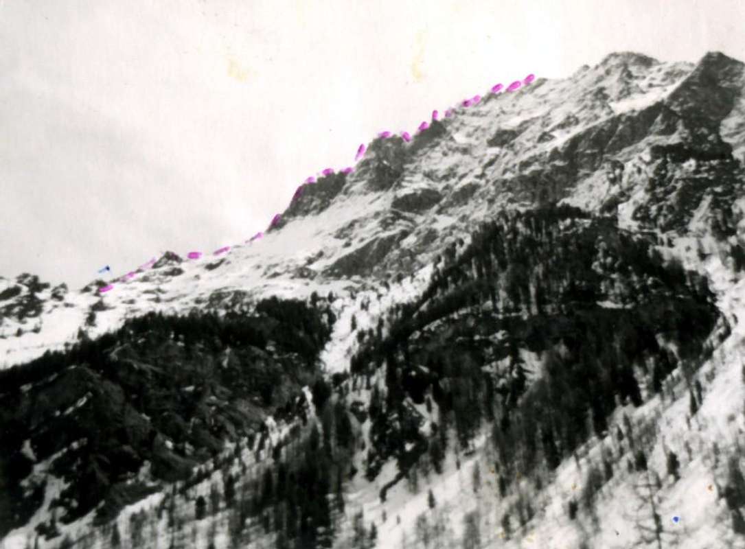
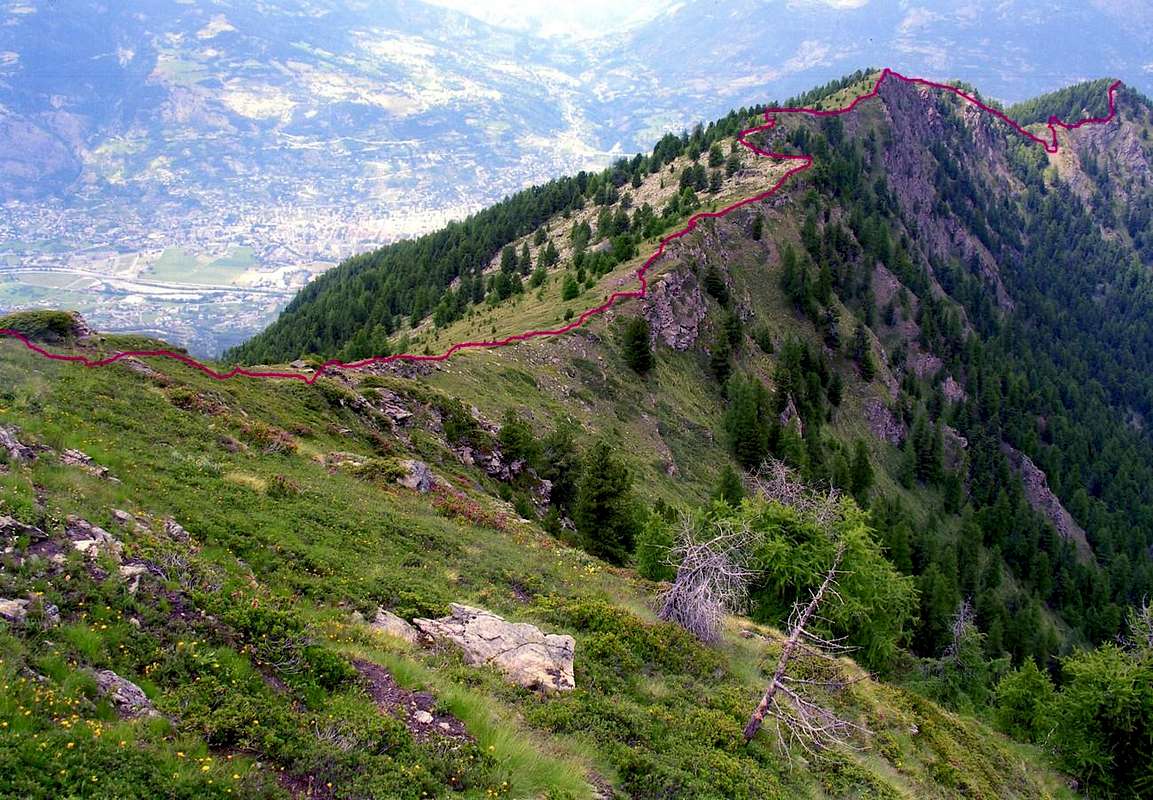
A) - South Ridge from the Hill Plan Fenêtre (2.229m) crossing the Point of Ponteilles and the Point Valletta (Standard or more easy and simply Route): from the Plan Fenêtre Pass (see the various Approaches ) to go up again to Northeast a brief grassy line through a small path arrived to the Summit of the Point of Ponteilles (2.282m), preceded by a tall cross in wood rather placed on a panoramic back; from this continuing inside the wood, that the crest reaches watershed with precipice to East toward the Vallon of the Comboé, "to make himself light" through the same and with more annoying passages, cause the branches of the trees and the big roots, that difficult to go down the same one reaching a small carving, where in practice the winding wood the Point of Ponteilles finishes. Overcome a first quota, to form of back not named and meaningless, the dividing crest with run more "open" and always with direction North in light and progressive slope reaches the Point Valletta (2.164m ; * not to confuse with the Point of the Valletta to the Southern beginning of the same watershed) and from this to reach the similar quota 2.145/6 meters, easily stung from which the crest begins to turn more toward Northeast. With elementary and sure run to reach the Point of the Dard (quota 2.033 meters I.G.M or Italian Institute Geographic Military.), extreme knot of the same buttress, dividing the homonym vallon from a small "vallone" impending the Alp of Combatissière (1.750m; two ancient splendid "rascards" in wood) to the Oriental extremity of the whole Basin of Pila Center Ski Resort-Touristic. This ascension constitutes to particular houses as the normal street to the Crest Paganini in the GROUP of the Apostles, because happens, departing from the Hill Plan Fenêtre through an atypical "climbed in descent." (E; 0h'45/1h'00 from the Plan Fenêtre Pass; 1h'45/2h'00 from Pila).
A)- Cresta Sud dal Colle Plan Fenêtre (2.229 m) scavalcando la Punta di Ponteilles e la Punta Valletta (Via Normale ed anche più facile e semplice): dal Colle Plan Fenetre (vedi i vari Approaches) risalire a Nordest un breve tratto erboso tramite un piccolo sentiero adducente alla Sommità della Punta di Ponteilles (2.282 m), preceduta da un'alta croce in legno situata su d'un dosso alquanto panoramico; da questa continuando all'interno del bosco, che raggiunge la cresta spartiacque con precipizio ad Oriente verso il Vallone del Comboé, "farsi luce" attraverso lo stesso e con passaggi più fastidiosi, causa i rami degli alberi e le grosse radici, che difficili scendere la stessa raggiungendo un intaglietto, ove in pratica il bosco avvolgente la Punta di Ponteilles termina. Superata una prima quota, a forma di dosso non nominata ed insignificante, la cresta divisoria con percorso più "aperto" e sempre con direzione Nord in leggera e progressiva salita raggiunge la Punta Valletta (2.164 m; * da non confondere con la Punta della Valletta all'inizio Meridionale dello stesso spartiacque) e da questa facilmente raggiungere la similar quota 2.145/6 m, punto dal quale la cresta incomincia a volgere più verso Nordest. Con percorso elementare e franco raggiungere la Vetta o Punta del Dard (quota 2.033 m. I.G.M.), nodo estremo dello stesso contrafforte, divisorio il Vallone omonimo da un valloncelle soprastante l'Alpe di Combatissière (1.750 m; due antichi splendidi "rascards" in legno) all'estremità Orientale dell'intero Bacino Sci-Turistico di Pila. Questa ascensione costituisce un caso particolare, come la via normale alla Cresta Paganini nel Gruppo degli Apostoli, perché avvienne, partendo dal Colle Plan Fenêtre tramite un'atipica "salita in discesa" (E; 0h'45/1h'00 dal Colle Plan Fenetre; 1h'45/2h'00 partendo da Pila).
 |
 |
 |
 |
 |
B) - Directly for the East Slope: using the various Approaches that, passing for the Les Pousses Pastures (or through those that climb from the deep valley or from the low one and from the average hill-mountain of the Commune of Charvensod; to see above the specific Approaches), all addressed toward the Alp and the adjoining Fall of Ponteilles (1.706m and from 2.000 meters to 1.750 meters around), to the conjunction of the superior enough wide Valley of the Comboé with the underlying one of the Dard, to go up again, in every houses, up to alternative the 1.612 meters, where the path n° 14 comings from the fund of the "vallone" macaws crossed with the dirt road "poderale", that salt from the Alp Les Pousses, really near the Torrent of Comboé. Don't cross the Torrent continuing toward Ponteilles, on the contrary, abandoning the path, to begin to climb toward West crossing the path n° 14D, coming from Les Pousses and the neighbor Ru Dessus (Brook than Above, action to the irrigation); to take to climb in direction of the Oriental Slope of the Point of the Dard crossing a first small wood with shed trees and groud stones and reaching a grassy clearing. Crossed it, to reach a second strip of trees to which it follows a following similar but steep grassland at the base of a steep wall-ribbing that directly goes down from the Peak. Gone beyond a less consistent further line of trees, exploiting the steep grassy gully that accompanies him to Midday, or, in case of tall snow with relative danger of slavine (you see 1966 various photos), to exploit the same rocks to their base, with climb not always easy on non good rock and that it has the tendency to crumble himself. To go up again so the whole great channel or his bank orographic of left (North) thin to arrive to a small rocky pulpit, as soon as to North of the Top; to conclude through the slender, but easy one, Crest North, that goes up again shortly to the Peak (*** another gully similar parallel salt more to South reaching directly the Point, but it is unadvisable to climb it because he offers less possibility to protect himself under the aforesaid snowy conditions; EE/A; F/F+; 1h'00/1h'30 from the alternative 1.612 meters, but very varying in presence of snow).
B) - Direttamente per il Versante Est: utilizzando i vari Avvicinamenti che, passando per l'alpe Les Pousses (oppure tramite quelli che montano dal fondovalle o dalla bassa e dalla media collina-montagna del Comune di Charvensod; vedere sopra gli Approaches specifici), tutti indirizzati verso l'Alpe e l'attigua Cascata di Ponteilles (1.706 metri e da 2.000 metri a 1.750 metri circa), alla congiunzione del superiore Vallone del Comboé con il sottostante del Dard, risalire, in ogni caso, fino al bivio 1.612 metri, dove il sentiero n° 14 proveniente dal fondo del vallone si incrocia con la strada poderale, che sale dall'Alpe Les Pousses, proprio nei pressi del Torrent de Comboé. Non attraversare il Torrent proseguendo verso Ponteilles, bensì, abbandonando il sentiero, iniziare a salire verso Occidente attraversando il sentiero n° 14D, proveniente da Les Pousses, ed il vicino Ru Dessus (= Ruscello di Sopra, atto all'irrigazione); prendere a salire in direzione del Versante Orientale della Punta del Dard attraversando un primo piccolo bosco con alberi sparsi e pietraia e raggiungendo una radura erbosa. Attraversatala, raggiungere una seconda striscia di alberi alla quale segue una successiva similare ma più scoscesa prateria, alla base di una ripida parete-nervatura che scende direttamente dalla Vetta. Oltrepassata un'ulteriore fila di alberi meno consistente, sfruttando il ripido canalone erboso che l'accompagna a Mezzogiorno, oppure, in caso di neve alta con relativo pericolo di slavine (vedere le varie foto del 1966), sfruttare le rocce medesime alla loro base, con arrampicata non sempre facile su roccia non buona e che tende a sgretolarsi. Risalire così l'intero grande canale o la sua sponda orografica di sinistra (Nord) fino ad arrivare ad un piccolo pulpito roccioso, appena a Settentrione della Cima; concludere per mezzo della esile, ma facile, Cresta Nord, che in breve risale alla Vetta (*** un altro canalone similare sale parallelo più a Sud raggiungendo diettamente la Punta, ma è sconsigliabile il salirlo perché offrente meno possibilità di proteggersi nelle condizioni nevose predette; EE/A; F/F+; 1h'00/1h'30 dal bivio 1612 m, ma molto variabile in presenza di neve).
 |
 |
 |
 |
 |
C) - Through the Black Forest of Combatissière and the Northern Slope: from the Alp of Combatissière (1.750m), mainly reached with the path n° 14L that from Pila Resort it reaches the Hermitage of Saint Grat and therefore, previous small and steep descent on excavated dirt road "poderale", the alp; not to reach the same superior, restructured recently, on the contrary, about fifty meters to take a small path, traced before, by the Forester and to follow it first toward East-southeast and then Northeast that loses him in the intrigue of the Black Forest of Combatissière, in a zone of great rocks covered by the musk and by dead branhs. From this point the itinerary becomes adventurous, asking for the ability to disentangle himself inside a sharp pain and, perhaps, unexplored forest. Over the itinerary and the choice of the road they become complexed and they ask for a certain ability of orientation and to know to choose the best street among the dense wood and some rocky "banconates" that they since continually alternate, rather increasing in steepness and making problematic a great deal the prosecution of the slope. He is not set neither for the neophytes, neither for the inexperienced persons gotten used tabbed to behind slavishly him one the other as to the Mount Blanc, to the Breithorn, to the Gran Paradiso to the Rutor etc; here it takes eye and ability at least not to go to crush to viper, also because paths or signalings of sort don't exist. However at the end, with some patience, it comes to head reaching the Crest North to not a lot of distance from the Peak. This run coincides a few with that practicable through the Crest North with departure from the Alp of Les Pousses, at least in the terminal part; in every case they are both unadvisable ones for the difficulties that display during the slope, such not to be suitable to the mass. (EE/A; F+; 1h'00/1h'30 from the Alpage of Combatissière).
C) - Attraverso la Foresta Nera di Combatissière ed il Versante Settentrionale: dall'Alpe di Combatissière (1.750 m), raggiunta principalmente con il sentiero n° 14L che da Pila raggiunge il piacevole e tranquillo Eremo di San Grato e quindi, previa piccola e ripida discesa su strada sterrata "poderale", l'alpe; non arrivare fino alla stessa superiore, ristrutturata recentememente, bensì, una cinquantina di metri prima, afferrare un sentierino, tracciato dalla Guardia Forestale e seguirlo prima verso Est-sudest e poi Nordest, che si perde nell'intrigo della Foresta Nera di Combatissière, in una zona di grandi massi ricoperti dal muschio e da ramaglie. Da questo punto il salire diventa avventuroso, richiedendo la capacità di districarsi all'interno di una fitta e, forse, inesplorata foresta. Oltre l'itinerario e la scelta della strada diventano complicati e richiedono una certa capacità di orientamento e di saper discernere la migliore via tra il bosco fitto ed alcune banconate rocciose che si intervallano continuamente, aumentando alquanto in ripidezza e rendendo problematica assai la prosecuzione della salita. Non é posto né per i neofiti, né per i pivellini abituati ad incolonnarsi pedissequamente uno dietro l'altro come al Bianco, al Breithorn, al Gran Paradiso al Rutor etc; qui ci vuole occhio e capacità almeno di non andare a pestare una vipera. Comunque alla fine, con un poco di pazienza, se ne viene a capo raggiungendo la Cresta Nord a non molta distanza dalla vetta. Questo percorso coincide un poco con quello effettuabile tramite la Cresta Nord con partenza dall'Alpe di Les Pousses, almeno nella parte terminale; in ogni caso sono entrambi sconsigliabili per le impervietà che ostentano durante la salita, tali da non essere indicate alla massa. (EE/A; F+; 1h'00/1h'30 dall'Alpe di Combatissière).
 |
D) - Through the Black Forest and the Western Slope: also the Western Slope of the mountain doesn't appear among the most advisable for a possible slope, since steep, steep and complicated. Nevertheless to street of slope that turns him to the neighbor Punta Valletta exists (2.164m), that was anciently used always departing from the line of intermediary path among the hermitage of Saint Grat and the Alps of Combatissière, as he is read in RM of the C.A.I 1889, pages 6-10, speaking of the presumed first winter slope to Nona's Becca at: "Comé drives her, all of to sudden it made us abandon the road that conducts in the Vallon of the Dard for Pouce and Ponteilles, and to fold up to the right toward the farms of Pessinas, from which continuing to climb above for the briefest uphill street torch of the mountain for the steep colanders that serves to the skid of the livestock, we touched the farms of Combatissière and the Fountain of Currant (**** not of the fruit currant, on the contrary of the Rebès, in patois of Aosta's Valley, or that it is undoubled; n.d.r.), crossing then the Black Forest of Combatissière, in head to which was reached the crest of the small buttress that the Vallon of the Dard separates from the inlet of Chamolé and the Hermitage of Saint Grat… We continuous on the crest toward south, and overcome to hump we found us on the Hill of Plan Fenêtre sinking deeply in the snow.". For this slope, to only enunciate from the historical point of view, times, difficulty and consideration of that are worth to the preceding route.
D) - Tramite la Foresta Nera ed il Versante Occidentale: anche il Versante Occidentale della montagna non appare tra i più consigliabili per un'eventuale salita, poiché scosceso, dirupato e complicato. Tuttavia esiste una via di salita che si rivolge alla vicina Punta Valletta (2.164 m), che veniva anticamente utilizzato partendo sempre dal tratto di sentiero intermedio tra l’Eremo di San Grato e le Alpi di Combatissière, come si legge in RM del C.A.I 1889, pagine 6-10, a proposito della presunta prima salita invernale alla Becca di Nona: "La guida Comé, ad un certo punto, ci fece abbandonare la strada che per Pouce e Ponteilles conduce nel vallone del Dard, e piegare a destra verso i casolari di Pessinas, dai quali proseguendo a salire per la più breve erta faccia del monte su per i ripidissimi colatoi che servono allo slittamento del bestiame, toccammo i casolari di Combatissière, e la fontana di Ribes (**** non del frutto ribes, bensì del Rebes, in patois locale, ovvero che si sdoppia; n.d.r.), attraversando poi la foresta Nera di Combatissière, in capo alla quale si raggiunse la cresta del piccolo contrafforte che separa il vallone del Dard dalla insenatura di Chamolé e dell'Eremitaggio di San Grato … Proseguiamo sulla cresta verso sud, e superata una gobba ci trovammo sul colle di Plan Fenêtre affondando profondamente nella neve.". Per questa salita, da enunciare solamente dal punto di vista storico, valgono tempi, difficoltà e considerazione di quella alla precedente route.
 |
 |
Campings
Remember that free camping is forbidden (except for emergency reasons, over 2.500m, from darkness until dawn).Mountain Condition
- Meteo: you can find all the needed informations at the official site of the Valle d'Aosta Region:
- Valle d'Aosta Meteo
Books and Maps
- "Guida del Monte Emilius", di Osvaldo Cardellina Editore in collaborazione con il Club Alpino Italiano Sezione di Aosta, Dicembre 1978.
- "Guida dei Monti d'Italia – Emilius Rosa dei Banchi Parco del Mont Avic" di Giulio Berutto e Lino Fornelli - Club Alpino Italiano/Touring Club Italiano, Marzo 2005.
- "Guida delle Alpi Occidentali" di Giovanni Bobba e Luigi Vaccarone C.A.I. Sezione di Torino Volume II (parte II), 25 Maggio 1896.
- "80 itinerari di Escursionismo Alpinismo e Sci Alpinismo in Valle d'Aosta", di Osvaldo Cardellina, Ed. Musumeci, Giugno 1977 (in Italian); seconda Ed. Luglio 1981; terza Ed. Luglio 1984; (in French), prima Ed. Febbraio 1978; seconda Ed. Marzo 1980.
- "Diari Alpinistici" di Osvaldo Cardellina e Indice Generale accompagnato da Schedario Relazioni Ascensioni 1964-2019 (inediti).
 |
 |
 |
- Kompass "Gran Paradiso Valle d'Aosta Sentieri e Rifugi" Carta turistica 1:50.000.
- L'Escursionista "Conca di Aosta-Pila-Monte Emilius" Carta dei sentieri (n° 4) 1:25.000.
- Hapax "Les Sentiers Comunità Montana Monte Emilius", Luglio 2000 1:25.000.
- Enrico Editore Ivrea-Aosta "Gruppo del Gran Paradiso" 1:50.000.
- I.G.C. Istituto Geografico Centrale, Torino "Carta delle Passeggiate ed Escursioni in V.D.A. Conca di Pila-Gressan, 1:20.000.
Important Information
- REGIONE AUTONOMA VALLE D'AOSTA the official site.
- FONDAZIONE MONTAGNA SICURA Villa Cameron, località Villard de la Palud n° 1 Courmayeur (AO) Tel: 39 0165 897602 - Fax: 39 0165 897647.
- A.I.NE.VA. (Associazione Interregionale Neve e Valanghe).
Useful numbers
- Protezione Civile Valdostana località Aeroporto n° 7/A Saint Christophe (Ao) Tel. 0165-238222.
- Bollettino Valanghe Tel. 0165-776300.
- Bollettino Meteo Tel. 0165-44113.
- Unità Operativa di Soccorso Sanitario Tel. 118.