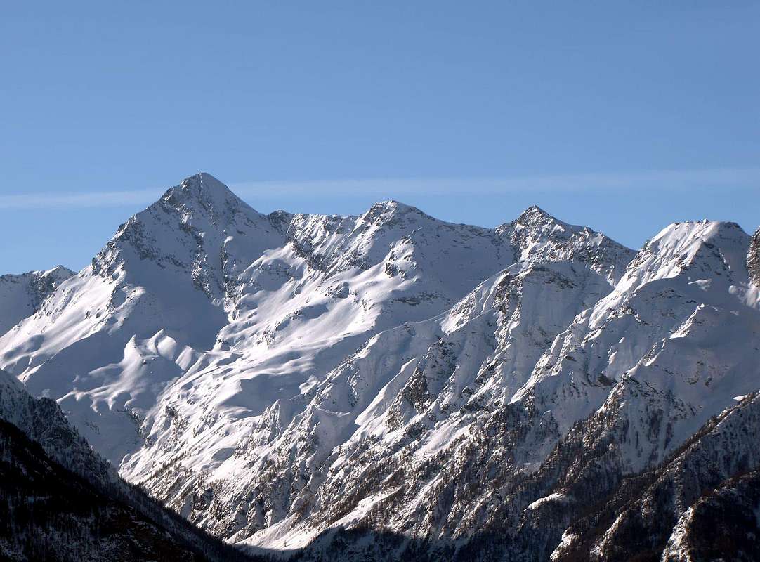
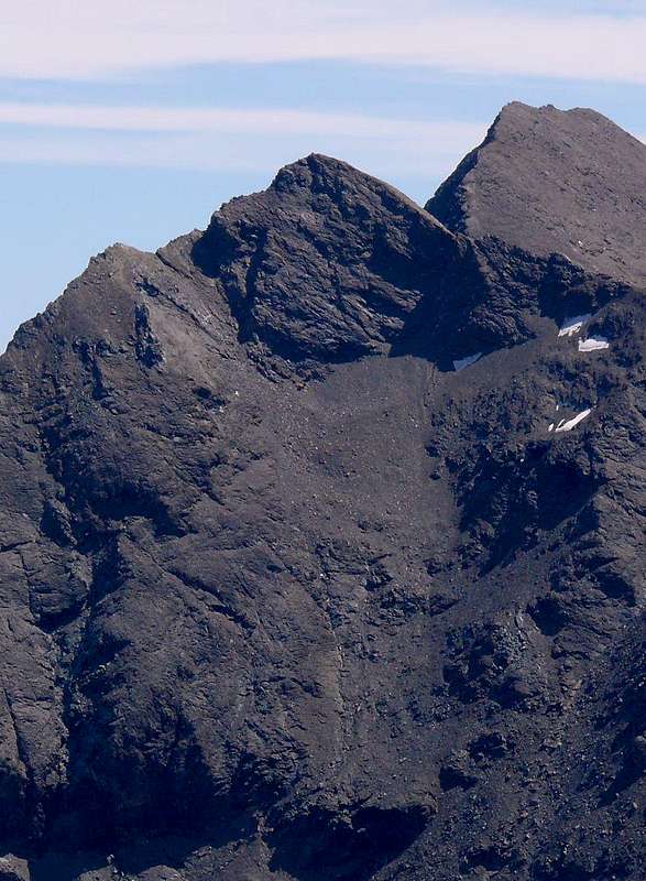
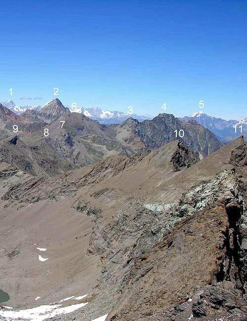
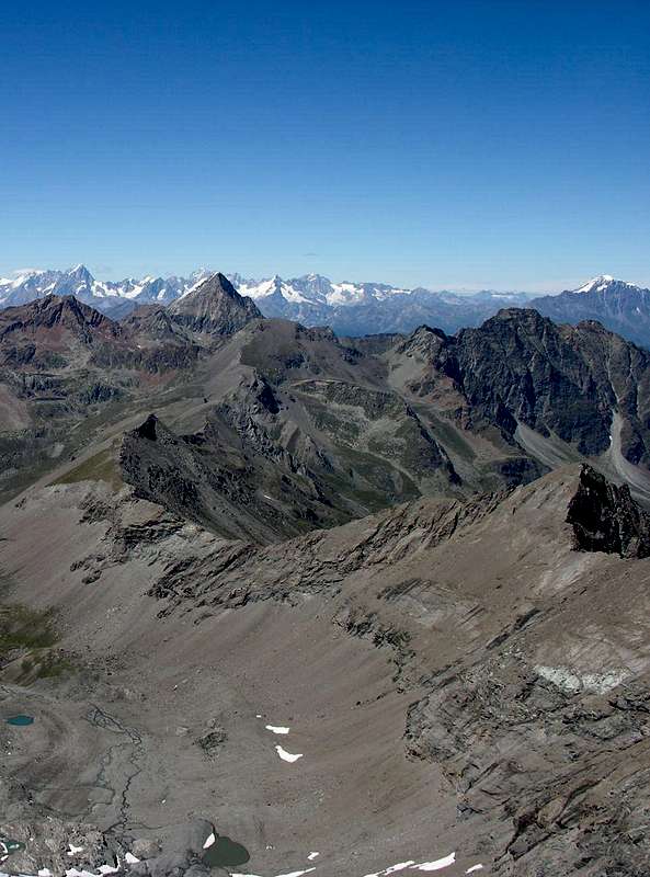
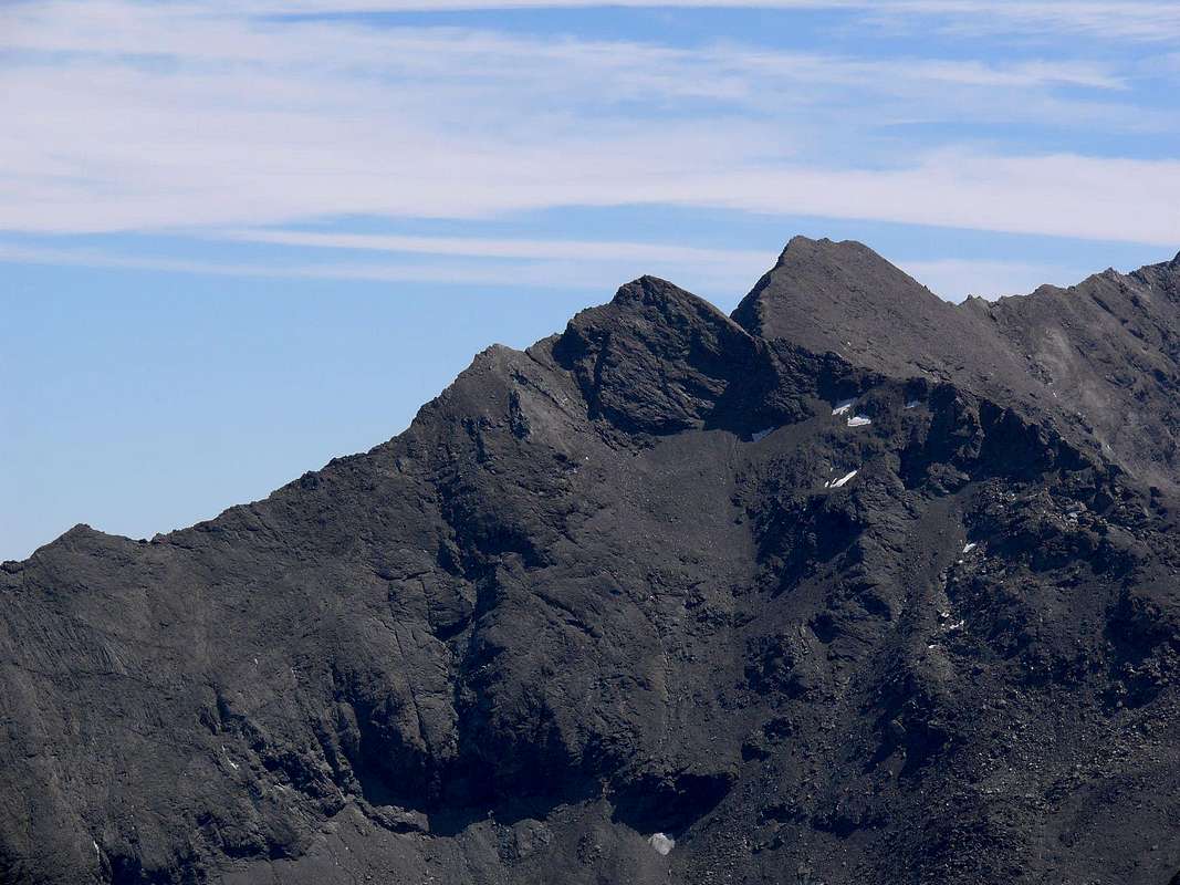
Situated on the long ridge from Punta Tersiva (3.515m) towards the North on the same doubling its (a branch North to the Group of Grand Avert and a second more Northwest to the Saint Marcel Hill and the Tip Leppe), it is and regular triangular pyramid with three ridges and an equal sides. The first or Crest Southeast connects precisely to Tersiva, after having formed a large hump said Coast Tessonet and also Coast of Tersiva (3.311m); the second goes North to the Lavodilec Hill Petit and Grand Avert. The last shall be directed to the West, reaching the Collar Tessonet (3.051m), which separates it from the next Punta Gianni Vert (3.148m); this is the so-called "Normal Route" to climb, even if this mountain is really very poorly achieved. Contrary to that of the former Gamekeeper Osvaldo Pianfetti said "Yogi" (+ August 2013), which has controlled the Reserve Turati in the Valley of Saint Marcel for over twenty years, almost never the same and he has reached in a few occasions, almost always linked to his work. If on this side of the climbs can be counted on your fingers, yet least visited apparent from the Valley of Grauson, branch Doreire-Tessonet. A large cliff falls on this side, and the same is extended until the Collar Tessonet making it more difficult and less easy to climb than from that of Saint Marcel. Almost better achieve the same with a short descent from Punta Gianni Vert, using large blocks stacked. Various factors are the lack of interest for this mountain:
1) - the length of both approaches from Saint Marcel (Les Hautes Druges) that the Valley of Cogne (Gimillan and Vallon of the Grauson);
2) - the quality of the rock very broken and even crumbled, and often covered by fine debris. In addition,
3) - the view of this big jump, side Tessonet, which certainly does not encourage and, last but not least,
4) - the fact that the same is "choked" by the much higher and famous Tersiva. If we want to add, even the view from the north (Grande Chaux) invites certainly not as if up to thirty years ago about the same possessed a more elegant look, thanks to the covering of a long snowfield that clothed from the base almost to the summit , which actually looks bleak rocky scree slope with a small snowfield at the base.
Situata sulla lunga cresta che dalla Punta Tersiva (3.515 m) si dirige verso Settentrione sdoppiandosi proprio sulla medesima (un ramo a Nord verso il Gruppo del Grand Avert ed un secondo maggiormente a Nordovest verso il Colle di Saint Marcel e la Punta di Leppe), risulta piramide triangolare e regolare con tre creste ed altrettanti versanti. La prima o Cresta Sudest la collega proprio alla Tersiva, dopo aver formato una grande gobba detta Costa del Tessonet ed anche di Tersiva (3.311 m); la seconda scende a Nord verso il Colle di Lavodilec ed il Petit Avert. L'ultima si indirizza verso Ovest raggiungendo il Colletto Tessonet (3.051 m), che la separa dalla successiva Punta Gianni Vert (3.148 m); questa costituisce la cosiddetta "Via Normale" di salita, anche se questa montagna è veramente molto scarsamente raggiunta. Anzi a detta dell'ex Guardiacaccia Osvaldo Pianfetti detto "Yoghi" (+ Agosto 2013), che ha controllato la riserva Turati nel Vallone di Saint Marcel per oltre un ventennio, quasi mai e lui stesso l'ha raggiunta in poche occasioni, quasi sempre legate al suo lavoro. Se su questo versante le ascensioni si contano sulla punta delle dita, ancora meno visitata risulta dal Vallone del Grauson, ramo di Doreire-Tessonet. Un grande dirupo cade sopra questo lato e lo stesso si allunga fino al Colletto Tessonet rendendo più problematica e meno semplice la salita che non da quello di Saint Marcel. Quasi meglio raggiungere il medesimo con breve discesa dalla Punta Gianni Vert, tramite grossi blocchi accatastati. Vari fattori costituiscono lo scarso interesse per questa montagna:
1) - la lunghezza degli avvicinamenti sia da Saint Marcel (Les Druges Alte) che dalla Valle di Cogne (Gimillan e Vallone del Grauson);
2) - la qualità della roccia molto rotta ed addirittura sgretolata, nonché ricoperta spesso da fine detrito. Inoltre
3) - la vista di questo grande salto, versante Tessonet, che non incoraggia certamente e, buon ultimo,
4) - il fatto che la medesima risulta "soffocata" dalla ben più elevata e famosa Tersiva. Se vogliamo aggiungere, anche la vista da Settentrione (Grande Chaux) non invita certamente, poiché se fino ad un trentennio circa or sono la stessa possedeva un aspetto più elegante, grazie al rivestimento di un lungo nevaio che la rivestiva dalla base quasi fino alla Sommità, oggi si presenta quale squallido versante detritico roccioso con un minuscolo nevaio alla base.
Firts Ascents
In the Summit: Unknown or, probably, Bobba with Mountain Guide Valtournanche Sylvain Pession, (Summer 1902), through crossing from Tersiva to Tessonet Collars.
In Winter: Unknown.
SE Ridge: Giovanni Bobba and Guide Valtournanche Sylvain Pession, (Summer 1902), in ascent through crossing from Tersiva Collar and Tessonet Coast.
W Crest (Standard Route): Giovanni Bobba and Valtournanche Mountain Guide Sylvain Pession, (Summer 1902), in descent to Tessonet Collar.
Bobba-Pession 1902 Via from Tersiva Collar
N-NW Slope: Osvaldo Cardellina, lone, (Aug 28th, 2003), in ascent from Les Druges Alte, Saint Marcel Vallon and Grande Chaux Hunting House.
N Ridge: Osvaldo Cardellina, lone, (Aug 28th, 2003), in descent to Lavodilec Hill towards Petite Chaux and Upper Les Druges Village.
N Crest (left) & N-NW Face 2003 Routes
Getting There to St. Marcel
BY CAR:
From Torino, Milano, etc: Motorway A5. Exit Aosta est For Grand Brissogne and Saint Marcel.
From Switzerland: through the Grand St. Bernard Tunnel or the homonym Pass. Drive to Aosta, For Grand Brissogne and Saint Marcel.
From France: through Mont Blanc Tunnel or Petit St. Bernard Pass. It isn't necessary to enter in Motorway A5, you can drive through SS.26 Aosta direction. Exit Aosta est For Grand Brissogne and Saint Marcel.
BY PLANE:
Aeroporto "Corrado Gex" Saint Christophe (Aosta).
Specific main Road towards St. Marcel Valley
From the rotunda to the entry of the Country of Saint Marcel, to go up over on a wide bridge the River Dora Baltea, bringing himself in the center of the same in direction of his great Church; to edge it and to continue with manifold indications for which thing, with the purpose not to be wrong, to follow the poster of brown color with the wording "Sanctuary of Plout." To go up again toward South with the regional road in succession toward the Fractions of Crétaz (653m) and then, decidedly toward East, of Jayer (693m) and Mezein (793m); immediately after this point, leaving on the left a ramification that goes down to the Country of Fénis (prohibition of transit for the cars), the road changes completely direction toward Southwest to reach the Village of Réan (898m) and, through a long diagonal, the famous Plout Sanctuary (898m), where from centuries a procession happens departing really from Saint Marcel. Doubling it same the road is again addressed to thin East to a wide hairpin-road, where it reenters toward the preceding direction reaching the Village of Seissogne (1.066m) and, through great grasslands, the following one of Sazailland (1.220m); they follow those of Ronc (1.359m), Viplana (1.346m), Champremier (1.383m), over which he leaves on the left a deviation for the tall alpis of the Commune of Fénis (passable and open to the traffic) to reach the alternative for Porteron and the following place of Leycher (1.506m; famous "Inn of the Devil"). Returning to East, the road leaves in low the short deviation for Low Les Druges (1.567m) to reach later immediately to Upper Les Druges (1.600m around; beautiful fountain near a small square "rascard" in wood and votive tiny Chapel dedicated to Saint Bernard).
Dalla rotonda all'ingresso del Paese di Saint Marcel, scavalcare su di un largo ponte il Fiume Dora Baltea, portandosi nel centro dello stesso in direzione della sua grande Chiesa; contornarla e proseguire con molteplici indicazioni per la quale cosa, al fine di non sbagliare, seguire i cartelli di colore marrone con la dicitura "Santuario di Plout". Risalire verso Sud con la strada regionale in successione verso le Frazioni di Crétaz (653 m) e poi, decisamente verso Est, di Jayer (693 m) e Mezein (793 m); subito dopo questo punto, lasciando sulla sinistra una diramazione che scende al Paese di Fénis (divieto di transito per gli automezzi), la strada cambia completamente direzione verso Sudovest per raggiungere il Villaggio di Réan (898 m) e, tramite un lungo diagonale, il celebre Santuario di Plout (898 m), dove da secoli avviene una processione partendo proprio da Saint Marcel. Doppiando lo stesso la strada s'indirizza nuovamente ad Oriente fino ad un largo tornante, dove rientra verso la precedente direzione raggiungendo il Villaggio di Seissogne (1.066 m) ed, attraverso grandi praterie, il successivo di Sazailland (1.220 m); seguono quelli di Ronc (1.359 m), Viplana (1.346 m), Champremier (1.383 m), oltre il quale si lascia sulla sinistra una deviazione per le alte alpi del Comune di Fénis (transitabile ed aperta al traffico) per raggiungere il bivio per Porteron e la successiva località di Leycher (1.506 m; rinomata "Locanda del Diavolo"). Ritornando ad Est, la strada lascia in basso la corta deviazione per Les Druges Basse (1.567 m) per pervenire subito dopo a Les Druges Alte (1.600 m circa; bella fontana presso un piccolo squadrato "rascard" in legno e Cappelletta votiva dedicata a San Bernardo).
Approach Saint Marcel
From Saint Marcel and through the Pass of Leppe: from Tall Les Druges Village (1.567m; fountain and little beautiful wooden "rascard", nearby the same), place Pouria Alp (1.586m after the "Les Druges Picnic Area) along the coincident earth road "poderale" with the path n° 3 that, passing through Vargney Pasture (1.676m; various iron and copper dumpings of mine) and doubling from West to South the terminal rocky-woody promontory of Mont Roux (2.277m), it forwards him in the long Vallon of Saint Marcel, that arrives to homonym hill before the Cogne Valley. (* RESERVE of Hunting Marquis Turati and the Baron's ex Reserve Beck Peck(c)oz) passing under the abandoned coppermines of Servette, among the 1.720 meters and the 1.810 meters.
a) - departing from the near of the Alp Pouria (place "garages" in to beautiful clearing of lawns with demolished pasture, just immediately under the road; present system of signs as soon as awry near the small torrent) and reaching the first one dark or lower part and old hand the miners' installation, in downfall but with fireplace to standing wall still, for finally to connect him to the precedent itinerary. Besides possibility of prosecution and variation of excursion for the Alpe Lavanché (2.271m), with the path n° 18, along the forest, through the mule track uses to the transport of the copper and iron minerals ones, with a characteristic passage on stony wall; from the same reenter to soil road through the small path n° 3 to crossroads 1.836m, near Praborna Pasture (1.882m) and its manganese mine.
b) - With start after Vargney Alp (1.676m), through, always, path n° 18, crossing in parallel with a small brook of irrigation and inside a good and thick forest, reaching the previous routes. To continue South direction, crossing at the foots of Westerner Slope of Mount Roux traversing the its woods, to (* * Hunting House Turati of Mulac (1.937m; beautiful fountain and statuary steinbock, both in wood; entrance of mines, also them abandon, of manganese near Praborna Pasture (= Lawn of the Hole; 1.882m. From the aforesaid crossroads, where the path on the left (East) the deviation for the Alp Lavanché the same very small path with numeration 3, to continue with the soil "poderale" road-path n° 4; the same one, formed a great handle after the bridge in wood preceding the Sinsein's Pasture (1.995m) and, through a steep line goes up again rather, after having forded two other secondary torrents, toward the Alps Dessous of Plan Ruè (2.100m and 2.129m). Exceeded even the two immediately successive Pastures of Emonin Lower and Upper (2.129m, 2.205m), you will reach to Layet (2.233m) above a little lake of the same name; The final stretch is steered in the Southwest reaches the House Hunting of Grande Chaux (2.370m; 2h'30/3h'00), located near the homonymous alp.
Da Saint Marcel e tramite il Col di Leppe: da Les Druges Alta (1.567 m; fontanile e splendido piccolo "rascard" in legno appresso la medesima), località Pouria (1.586 m) lungo la poderale coincidente con il sentiero n° 3 che, doppiato il roccioso e boschivo promontorio terminale del Mont Roux (2.277 m), si inoltra nel lungo Vallone di Saint Marcel, che perviene sino all'omonimo colle a cavallo con la Valle di Cogne. ( * RISERVA di Caccia Marchese Turati ed ex riserva del Barone Beck Peck(c)oz; passando al di sotto delle miniere abbandonate di rame di Servette tra i 1.720 metri ed i 1.810 metri.
a) - partendo dai pressi dell'Alpe Pouria (località "garages" in una bella radura prativa con alpe diroccata, subito sotto la strada; segnaletica presente appena a monte, presso il torrentello) e raggiungendo il primo o più basso e vecchio insediamento dei minatori, in rovina ma con camino a muro ancora in piedi, per infine ricollegarsi al precedente itinerario. Inoltre possibilità di prosecuzione per l'Alpe Lavanché (2.271 m) con sentiero n° 18, lungo la foresta per mezzo della mulattiera usa al traporto dei minerali del ferro e del rame, con un caratteristico passaggio su di un muraglione di pietra; dall'alpeggio rientrare sulla poderale per mezzo del sentierino n° 3 in direzione dell'incrocio 1.836 m, nei pressi dell'Alpe di Praborna (1.882 m) e della sua miniera di manganese.
b) - Con avvio dalla poderale oltre l'Alpeggio di Vargney (1.676 m), tramite sentiero n° 18, parallelamente ad un ruscelletto d'irrigazione nel fitto della bella foresta e così pervenendo ai precedenti itinerari. pervenendo, passando ai piedi del versante Occidentale del Mont Roux ed attraversandone i suoi boschi, alla (* * Casa di Caccia Turati a Mulac (1.937 m; bel fontanile e statuario stambecco, entrambi in legno); imbocco delle miniere, anch'esse abbandonate, di manganese a Praborna (= Prato della Buca; 1.882 m. Dall'incrocio predetto, ove il sentiero lasciata sulla sinistra (Est) la deviazione per l'Alpe Lavanché tramite il medesimo sentierino con n° 3, continuare con la strada poderale sentiero n° 4; la medesima, formata una grande ansa dopo il ponte in legno precedente l'Alpe di Sinsein (1.995 m), e, per mezzo di un tratto alquanto ripido, risale, dopo aver guadato due altri torrenti secondari, verso gli Alpeggi Dessous di Plan Ruè (2.100 m e 2.129 m). Oltrepassati anche i due subito successivi Alpeggi di Emonin Inferiore e Superiore (2.129 m, 2.205 m), si raggiunge quello di Layet (2.233 m) che precede di poco l'omonimo Lago; un ultimo tratto indirizzato maggiormente a Sudovest raggiunge la Casa di Caccia di Grande Chaux (2.370 m; 2h'30/3h'00), posta nelle vicinanze dell’omonima alpe.
From Gimillan in Cogne Valley
BY CAR:
From Torino, Milano, etc: Motorway A5. Exit in Aosta Ovest. Drive to the near Aymavilles. Follow in the direction of Valle di Cogne.
From Switzerland: through the Grand St. Bernard Tunnel or the homonym Pass). Drive to Aosta, then follow Courmayeur direction on SS.26. Just after Sarre, turn to the left, in the direction of Valle di Cogne.
From France: through Mont Blanc Tunnel or Petit St. Bernard Pass). It isn't necessary to enter in Motorway A5, you can drive through SS.26 Aosta direction. Before arriving at the Village of Sarre, follow the sign and turn right towards Valle di Cogne.
After Aymavilles, the SR.47 crosses the Villages of Vieyes, Epinel and Cretaz and after about 25 Km. arrives at Cogne (1.534m). Follow the road signs for Gimillan and Lillaz; arrived at a round-about, recently built in proximity of the St. Anthony Chapel, go left along the scenic route leading to the Village of Gimillan (1.787m), 3 Km. after Cogne. Usually no parking problem.
From Gimillan in Cogne Valley: Go right starting from the car park of Gimillan: after few meters the indications for Lussert Lakes, St. Marcel Pass or Coronas, etc. are found. The pathway n° 8/TVC is indicated by the yellow circle and by strips marked on stones along the route. The path begins going immediately up pass, then the slope decreases as we go beyond a little Chapel dedicated to the Virgin (1.836m). Soon the path resumes to go up and splits in two, before it begins to penetrate into the Grauson Vallon: it's possible to continue following the right one that goes down as far as the Ecloseur Bridge (1.904m), but in such a case we must go up again; it's better to follow the left one that, in practice without losing height, arrives at the bridge under the Alp Pila (2.025m), cross it and, following the stepped pathway, overcome the rocky bastion with a fine waterfall aside. At this point the path turns right markedly entering, high on the torrent, into a small valley; by an alternation of steep and slight slopes, it reaches a panoramic cross, on the edge of a pleasant plateau with splendid view of the far Grivola. The path goes through the meadows, slightly descendind: after the Alpages of Grauson Vecchie (2.271m; Old), cross the Torrent Doreire on the Pikaciù Bridge and begin again to go up, reaching the wide upper part of the Grauson, right or East branch named Doreire or Tessonet.
Da Gimillan in Valle di Cogne: Partendo dal parcheggio di Gimillan proseguire sulla destra: dopo pochi metri si incontrano le indicazioni per i Laghi del Lussert, il Colle di St. Marcel o Coronas, ecc. Il percorso è indicato dal cerchio giallo e da strisce segnate sulle pietre lungo il percorso. L'itinerario inizia subito in ripida salita, poi la pendenza diminuisce, dopo aver oltrepassato una Cappellina dedicata alla Vergine (1.836 m). Ben presto il sentiero n° 8/TVC riprende a salire dividendosi in due, prima che cominci a penetrare nel Vallone del Grauson: è possibile continuare a seguire quella di destra che scende fino al Ponte dell'Ecloseur (1.904 m), ma in questo caso si deve effettuare una risalita e quindi è meglio seguire quello di sinistra che, in pratica, senza perdere d’altezza, arriva al ponte sotto l'Alpeggio Pila (2.025 m); lo si attraversa e, seguendo il percorso a gradini, superare il bastione roccioso con una bella cascata a lato e frontalmente. A questo punto il sentiero piega a destra marcatamente entrando, alto sul torrente, in un valloncello; con una alternanza di pendii ripidi e lievi, raggiunge una croce panoramica, ai margini d'un piacevole altopiano con superba vista sulla Grivola. Il sentiero attraversa in leggera discesa i prati raggiungendo l'Alpe di Grauson Vecchie (2 271 m); da questa continuare ed attraversare il Torrente Doreire sul Ponte Pikaciù ricominciando a risalire, inserendosi nell'ampia parte superiore del vallone del Grauson, ramo di destra od Orientale e detto di Doreire ed anche del Tessonet.
Route
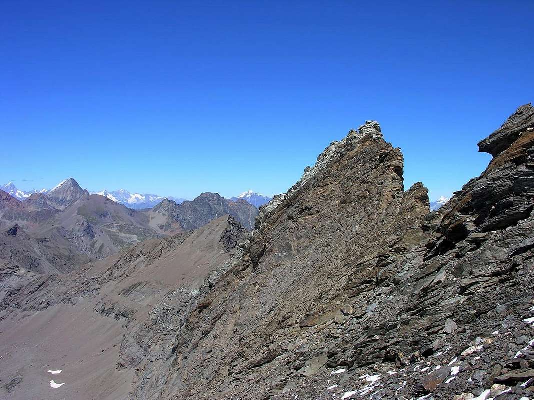
From the Collar Tessonet (3.051m), reached with one of the two previous Approaches the above, immediately bend to the East West Ridge taking on long enough and with direction just mentioned in Southeast easily reach an initial roughness in altitude 3.079 meters; go on easily, but most decidedly to the East and with a short bypass to the left (North) to arrive at a second elevation at an altitude of 3.191 meters. From this point on the ridge just becomes more difficult but "delicate" because of the plates, very exposed to the South, not very steep but covered with a very fine and dangerous debris that make it risky to climb. Carefully cross a small carving and subsequent plaque (I°+/II°-) and with a final stretch easier, almost walkable, you reach the Summit (F +; 0h'45/1h'00 from the Collar; 2h'45/3h'00 from Grande Chaux Hunting House; 5h'45/6h'15 from Upper Les Druges also 5h'30/6h'00 departing from Gimillan Hamlet in Valley of Cogne).
Dal Colletto Tessonet (3.051 m), raggiunto con uno dei due precedenti Avvicinamenti di cui sopra, piegare subito ad Oriente portandosi sulla abbastanza lunga Cresta Ovest e con direzione appena accennata a Sudest raggiungere facilmente una prima asperità in altitudine 3.079 metri; continuare ancora facilmente ma più decisamente verso Est e con qualche breve aggiramento a sinistra (Nord) pervenire ad una seconda elevazione a quota 3.191 metri. Da questo punto la cresta diventa appena più difficile ma "delicata" a causa di placche, molto esposte verso Sud, non molto ripide ma ricoperte da un pericoloso ed alquanto fine detrito che rendono pericolosa la salita. Con attenzione si supera un piccolo intaglio e la successiva placca (I°+/II°-) e con un ultimo tratto più facile, quasi camminabile, si raggiunge la Sommità (F+; 0h'45/1h'00 dal colletto; 2h'45/3h'00 dalla Casa di Caccia di Grande Chaux; 5h'45/6h'15 da Les Druges Alte oppure 5h'30/6h'00 con partenza dal Villaggio di Gimillan in Valle di Cogne).
Normal Via from Saint Marcel Vallon
Difficulty
From F to F+, but with delicate climbing.
Da F a F+, ma delicato.
Essential Gear
For Hiking, preferably with rope.
Da Escursionismo, meglio se con corda.
Campings
Remember that free camping is forbidden (except for emergency reasons, over 2.500m, from darkness until dawn).
Mountain Conditions
You can get meteo information at the official site of the Regione Valle d'Aosta:
"Guida delle Alpi Occidentali" di Giovanni Bobba e Luigi Vaccarone C.A.I. Sezione di Torino Volume II (parte II), 25 Maggio 1896.
"Guida dei Monti d'Italia – Emilius Rosa dei Banchi-Parco del Mont Avic" di Giulio Berutto e Lino Fornelli - Club Alpino Italiano/Touring Club Italiano, Marzo 2005.
"Diari Alpinistici" di Osvaldo Cardellina e Indice Generale accompagnato da Schedario Relazioni Ascensioni 1964-2019 (inediti).
MAPS:
Ingenia "Parco Naturale del Mont Avic" Carta dei sentieri 1:25.000.
Enrico Editori Ivrea "Carta turistica del Canavese" 1:100.000
Enrico Editore Ivrea-Aosta "Gruppo del Gran Paradiso" 1:50.000.
L'Escursionista editore "Valle di Champorcher Parco Mont Avic" Carta dei Sentieri (11) 1:25.000.
L'Escursionista "Valle di Cogne" Carta dei Sentieri 1:25.000.
Carta Hapax Escursionistica della Comunità Monte Emilius, 2° Edizione 2008 1:25.000.
I.G.C. di Torino "Ivrea Biella Bassa Valle d'Aosta" Carta dei sentieri e rifugi n° 9 1:50.000.
Parents refers to a larger category under which an object falls. For example, theAconcagua mountain page has the 'Aconcagua Group' and the 'Seven Summits' asparents and is a parent itself to many routes, photos, and Trip Reports.

 4158 Hits
 83.69% Score
 17 Votes