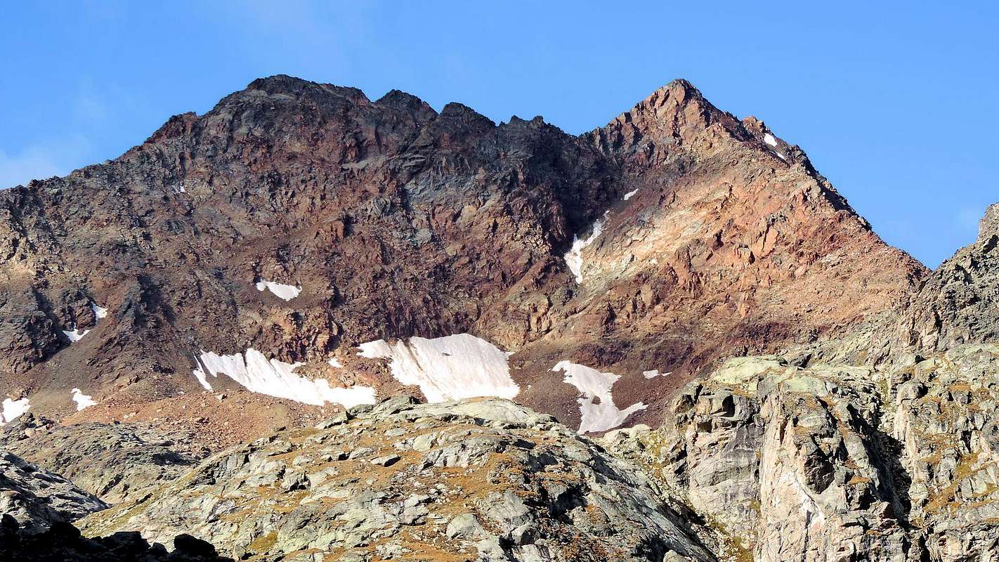
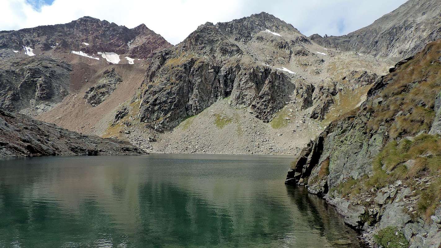
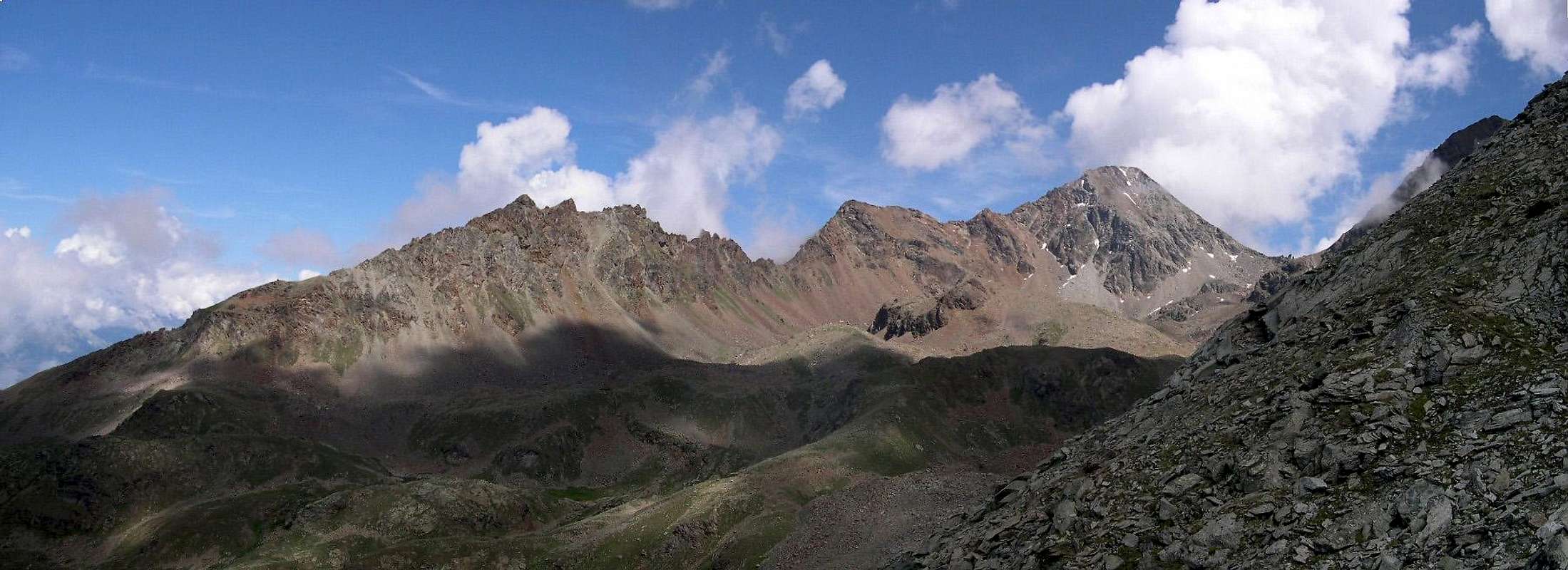
The Punta Rossa dell'Emilius (not to be confused with the many others having a similar name) is, considering as an integral part the near minor Summit of Punta des Laures (3.367m), a rather depressed but fairly regular pyramid with four ridges and four sides. This mountain has a strange big "S" shape, connected with the Punta Garin (3.451m) to the South and the highest Monte Emilius (3.559m) in opposite. Indeed, for a long time has been confused and even identified with the Punta of Laures from which is separated through a small saddle and that is completely between the two Vallons of Grauson Laures and having nothing in common with that of Arbolle; this last is the one that identifies the most eye-catching this Summit that projects on the same two of its sides (North and West). And precisely for this reason it is necessary to the specification "of Mount Emilius", because, in order to differentiate it from the many other homonyms Summit in existence in the world, it stands out because of its snowy North Face addressed completely and then in plain view during the ascent of the same with the Normal Route, also through the recent Via Ferrata Year 2004. Its walls, analyzing clockwise, are directed progressively to the North above the ancient Glacier of Mount Emilius said Glacier of Lago Gelato (Frozen Loch), East to the very wild Vallon of the Laures, South over a small vallon in the high Vallon of Grauson/Lussert and West over the long Vallon Arbolle that rises from the two homonymous lakes, at the hut of the same name, to Lake Gelato below the Southern and "smashed" slopes and rocky ribs of Mount Emilius. Unfortunately, the progressive and continuous increase of the temperature did not spare even this mountain, the beautiful North Slope cloaked in snow that became one with the underlying glacier is reduced to a miserable thing, leaving room for large debris flows dripping down beside broken and very rotten and broken rocky ribbings and crumbling rock, greatly increasing the risk of falling stones; not least the East Wall, where the white couloir that cuts through the middle of her now is only admirable until the beginning of the summer. The ridges instead descending towards the Col Arbolle Northeast, Southeast toward a small saddle predicted that separates it from the Punta des Laures, South-southwest in the direction of the Pas du Valaisan that separates it from the Pic Garin and finally to the Northwest with a little edge emphasized that falls up above the shores of Frozen Lake, adapted to separate the two sides of Northern and Western. The view is limited to just these two great pyramids that the "choke" closely, but offers good views of the Group of Roises close to many att, far out on Punta Tersiva and towards the Southwest, a major part of the great Chain of the Gran Paradiso and the Graian Alps, while the West dominated by the Mont Blanc with its glistening glaciers.
La Punta Rossa dell'Emilius (da non confondersi con le tant'altre che hanno un nome similare) è, considerandovi anche come parte integrante il vicino minor vertice della Punta des Laures (3.367 m), una piramide pittosto depressa ma abbastanza regolare con quattro creste ed altrettanti versanti; questa montagna possiede una strana forma a grande "S", collegata con la Punta Garin (3.451 m) a Sud e con il Monte Emilius (3.559 m) a Settentrione. Anzi per molto tempo é stata confusa ed addirittura identificata con la Punta des Laures, dalla quale é disgiunta tramite una selletta e che si trova completamente tra i due Valloni di Grauson e delle Laures, non avendo nulla da spartire con quello dell'Arbolle; quest'ultimo é quello che identifica in modo più vistoso questa Sommità proiettante sul medesimo due dei suoi versanti (Nord ed Ovest). Anzi proprio per questo motivo risulta necessaria la specificazione "del Monte Emilius", poiché, onde differenziare questa Cima dalle molte altre omonime in esistenza in giro per il mondo, essa si distingue proprio per la sua nevosa Parete Nord rivolta completamente e quindi ben in vista durante la salita del medesimo tramite la sua Via Normale, oppure la recente Via Ferrata esistente dall'estate del 2004. Le sue pareti, analizzando in senso orario, sono rivolte progressivamente a Nord sopra l'antico Ghiacciaio del Monte Emilius o anche detto e conosciuto come del Lago Gelato, ad Est verso il selvaggio Vallone delle Laures, a Sud sopra una piccola conca nell'alto Vallone del Lussert con i suoi quattro splendidi laghi ed a Ovest al di sopra del lungo Vallone di Arbolle risalente dai due omonimi laghi, presso il nuovo rifugio omonimo, insino al Lago Gelato sotto le "fracassate" pendici Meridionali del Monte Emilius. Purtroppo l'aumento progressivo e continuo delle temperature non ha risparmiato neppure questa montagna: il bel Versante Settentrionale quasi sempre completamente ammantato dalla neve che diventava corpo unico con il sottostante ghiacciaio s'é ridotto a ben misera cosa lasciando spazio ad ampie colate detritiche che scorrono a fianco di rotti e sgretolati costoloni rocciosi, aumentando notevolmente il pericolo di cadute di pietre; non di meno la Parete Est, dove il candido canalone che la solca nel suo mezzo é ormai ammirabile solo fino agli inizi dell'estate. Poi si tramuta in un'orrenda e repellente linea scura che incute rispetto ma anche una certa qual delusione. Le sue creste scendono invece verso Nordest al Col di Arbolle, a Sudest verso la piccola sella predetta che la divide dalla Punta des Laures, a Sud-sudovest in direzione del Pas du Valaisan che la separa dal Pic Garin ed infine a Nordovest con uno spigolo poco accentuato "cascante" fin sopra le sponde del Lago Gelato, atto a separare i due versanti Settentrionale ed Occidentale. Il panorama vien limitato proprio da queste due grandi piramidi che la "soffocano" dappresso, ma offre buone vedute sul vicino Gruppo delle Roises, sulla lontana Tersiva e, verso Sudovest, su una parte importante della grande catena montuosa del Gran Paradiso e delle Alpi Graie, mentre ad Occidente troneggia il Monte Bianco coi suoi lucenti ghiacciai.
First Ascents
First on the Summit: W.A.B. Coolidge, F. Gardiner con Christian e Rudolf Almer, (Aug 30th, 1891) in ascent by S-SW Ridge.
In winter: Anselmo Falcoz, lone, (Mar 11/12th, 1939), in ascent from Fernier Alp (Pila), Arbolle, Valaisan Pass and S-SW Ridge with traverse to Central, East Summit round trip; descent on same via to pass and by ski to Gimillan and Cogne. Second: Osvaldo Cardellina, lone, (Dec 23th, 2007), in ascent from Gimillan and by S-SW Wall of Eastern Summit and traverse towards Central and Western round trip, with descent through NE Crest to Arbolle Pass, Arbolle and Pila Resort.
W-SW Slope: Agostino Ferrari and Cogne Mountain Carrier B. Glarey, (Sep 14th, 1898), from Arbolle and below Valaisan Pass/S-SW Ridge.
W Face (Little Couloir directly to Western Summit): Osvaldo Cardellina, lone, (May 08th, 2008), in ascent from Gelato Lake.
W-NW Edge: Armando Poli and Massimo Ceccarelli, (May 23th, 1970), in ascent from Pila/Arbolle.
W-NW Edge: Osvaldo Cardellina, lone, (Jul 12th, 1990 and Dec 23th, 2007), in descent by Western Top to Gelato Lake.
N Wall (Western Top): Osvaldo Cardellina, lone, (Jun 08th,1997), in ascent from Pila.
N Wall (Central Summit, couloir of right): Walter Bianquin, Osvaldo Cardellina and Ilario Antonio Garzotto, (Aug 23th, 1965), in ascent-descent, from Grande Cerise. First repetition (more to the center or East): Osvaldo Cardellina, lone, (Aug 30th, 2009), in ascent from Pila, Chamolé, Arbolle, Gelato Lake, Lago Cappello.
N Wall (Central Summit, couloir of left): Anselme e Pierluigi Falcoz, (Aug 09th, 1932), in ascent from Pila. First repetition: Osvaldo Cardellina, lone, (Jul 11th, 1999), in ascent from Pila Resort, Chamolé Lake and Pass, Arbolle Vallon, Gelato Lake, Lago Cappello, Col d'Arbolle
N Wall (Directly to East Summit): Anselmo Falcoz and Luigi Mondini (Jul 05th, 1964), in ascent from Pila. First repetition: Osvaldo Cardellina, lone, (May 08th, 2008 and Jul 10th, 2009), in descent and in ascent always from Pila Resort, Chamolé Lake and Pass, Arbolle Vallon, Gelato Lake, Lago Cappello Col d'Arbolle.
N-E Arête: Gerolamo Segato, lone, (Summer 1910), in ascent probably from Pila Alpages and surely from Arbolle Pass.
E Wall (to Eastern Summit and crossing): Osvaldo Cardellina and Camillo Roberto Ferronato, (Aug 25th, 1974), in ascent from Pila and through Arbolle Pass.
S-SE Arête (East Summit with traverse): Osvaldo Cardellina and Camillo Roberto Ferronato, (Jul 25th, 1976), in ascent from Gimillan by South Spur P. des Laures. First repetition and first solo: Osvaldo Cardellina, lone, (Aug 02th,2009), in ascent from Gimillan Hamlet, Grauson Vieux Pasture, three Lussert Lakes, Col des Laures and Punta des Laures, this last through E-SE Crest (first solo).
S-SE Wall (Eastern Summit and crossing): Osvaldo Cardellina, lone, (Dec 23th, 2007), in ascent from Gimillan with descent to Arbolle/Pila, through NW Edge.
S Wall (Central Summit and crossing): Osvaldo Cardellina, lone, (Jun 22th, 2008), in ascent from Gimillan, crossing and descent to Valaisan Pass.
S-SW Wall (Western Summit): Osvaldo Cardellina, lone, (Jul 12th, 1990), in ascent from Gimillan, with descent through NW Edge to Arbolle/Pila.
& Old Routes, always by Various
Getting There
BY CAR:A) Pila
From the Aosta Est exit of the Motorway take SS 26 toward the city. Carefully follow the signs that point to the popular ski resort of Pila. Past the town of Pont Suaz, Strada Regionale n°18 starts to climb; after a few hairpins it reaches the City of Charvensod 746m, 3 km from Aosta. Another 10 km will take you to the Village of Peroulaz 1.382m; a final 5 or 6 km and a few more hairpins will eventually bring you to Pila 1.807m.
B) Gimillan, Cogne Valley
From Torino, Milano, etc: Motorway A5. Exit at Aosta Ovest. Drive to the nearby Aymavilles. Follow in the directions for Valle di Cogne.
From Switzerland: through the Grand St. Bernard Tunnel or the namesake pass). Drive to Aosta, then follow signs for Courmayeur along SS.26. Just past Sarre, turn left, in the direction of Valle di Cogne.
From France: through Mont Blanc Tunnel or Petit St. Bernard Pass). It isn't necessary to take Motorway A5, you can drive along SS.26 in the direction of Aosta. Before reaching the Village of Sarre, follow the sign and turn right towards Valle di Cogne. After Aymavilles, SR.47 crosses the Villages of Vieyes (1.142m), Epinel (1.452m) and Cretaz (1.499m) and then arrives at Cogne (1.534m) after a total of about 25 Km. Follow the road signs for Gimillan and Lillaz to a round-about, recently built in proximity of the St. Anthony Chapel, then go left along the scenic route leading to the Village of Gimillan (1.787m), 3 km from Cogne. Usually no parking problems.
BY PLANE:
"Corrado Gex" Airport, Saint Christophe (Aosta).
Route
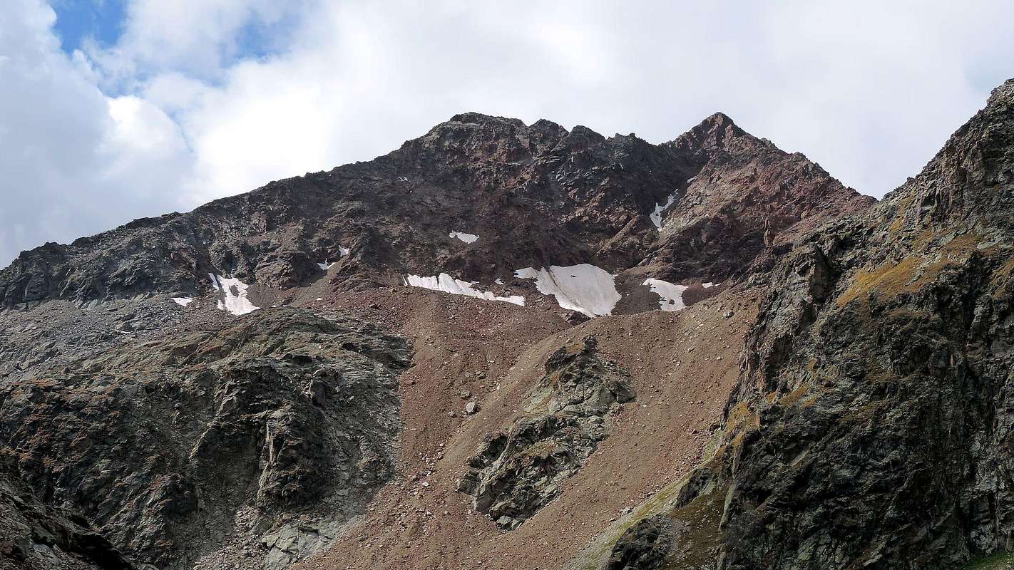
From Pila: (famous and crowded ski resort just above Aosta - Cableway or Bus service), to the Chamolé Lake (2.311m), using chairlift or on foot, and on to the homonymous pass (2.641m), through it go down to the new and comfortable Arbolle Refuge (2.510m); toward East till the Lago Gelato (2.956m), from this point you must go up in direction of the now no more snow-covered North Face of the Punta Rossa. From the Refuge paths 14/102. The route goes up to the close Arbolle Pass (3.154m), then, along the blocks and debris making up the Northeast Crest, leads to the Eastern Summit (3.400m); climbing and bypassing a prominence or Central Summit (about 3.395m), first on North side then on East side, requiring attention (exposed and bad quality rock). Going on along the ridge toward West the route leads to the true Summit of Punta Rossa (3.401m. It is recommended that, when the snow is still abundant and well established factor (now very rare) on the North Face of the just mentioned to go directly to the right of the snowy gully that flows between the North Wall of Western Top and Central Summit; doing so resulting structure will a fun climb on snow and ice is not too steep for about 300 meters.
In descent: not wanting to retrace the same route, should follow the Ridge South-southwest up to the Pas du Valaisan (3.153m) and then fall quickly after an initial stretch of hardened soil that forces a delicate traverse to the left against the wall of the Mont Valaisan (attention to the fall stones!), towards the underlying stony dark red and arranged in a radial pattern (crossing infinitely difficult, dangerous due to the instability of the boulders very sharp and dull) and the new Shelter Arbolle (7h'00/8h'00 round trip from Pila).
Standard Route from Pila through Northeast Crest 1974 and 2004, by emilius & Osw
Da Pila (nota località sciistica, raggiungibile da Aosta in auto pullman o funivia), pervenire al Lago di Chamolé (2.311 m; anche qui in seggiovia o a piedi), e l'omonimo colle superiore (2.641 m), per il quale si scende al comodo Rifugio Alpe di Arbole (2.510 m); dirigersi verso Est fino al Lago Gelato (2.956 m), donde salire in direzione della ormai non più nevosa Parete Nord della Punta Rossa. L'itinerario di salita tocca il vicino Colle di Arbole (3.154 m), per poi proseguire su blocchi e detriti della Cresta Nordest sino alla Punta Orientale (3.400 m); continuando sul crinale verso Ovest si raggiunge infine, dopo la Sommità Centrale (3.395 m~), la vera vetta della Punta Rossa (3.401 m). Si consiglia, quando la neve è ancora abbondante e ben assestata (fattore ormai più che raro) sulla Faccia Settentrionale di proseguire direttamente per l'appena accennato canale nevoso di destra della Parete Nord che sbocca tra la Punta Occidentale e quella Centrale; così facendo si otterà una divertente salita su neve e ghiaccio non troppo ripida di circa 300 metri.
In discesa: non volendo ripercorrere la via di salita tramite i due itinerari suddescritti, conviene seguire la facile Cresta Sud-sudovest, tenendosi sulla destra (Ovest) del crinale, sino al Pas du Valaisan (3.153 m) e da questo calarne velocemente, dopo un tratto iniziale su terriccio pericolosamrnte indurito che costringe ad una delicata traversata a sinistra contro la parete del Mont Valaisan (attenzione alla caduta di pietre!), verso la sottostante pietraia di colore rosso scuro e disposta a raggiera (traversata infinitamente faticosa, richiedente attenzione causa l'instabilità dei massi molto taglienti e noiosa) nonché il nuovo Rifugio di Arbolle (Complessivamente in salita/discesa da Pila 7h'00/8h'00~).
Standard and Other Routes from Pila, Les Laures and Gimillan, by Antonio, emilius & Osw
From Gimillan:(1.787m) go right starting from the car park of Gimillan: after few meters the indications for Lussert Lakes, St. Marcel Pass, etc. are found. The pathway is indicated by the yellow circle 9A and by yellow strips marked on stones along the route. The path begins going immediately uphill, then the slope decreases as we go beyond a little Chapel dedicated to the Virgin (1.836m). Soon the path resumes to go up and splits in two (wooden and yellow panel signage), before it begins to penetrate into the Grauson Walloon: it's possible to continue following the right, through a long diagonal crossing high above the Torrent Gru, one that goes down as far as the Ecloseur Bridge (1.904m), but in such a case we must go up again with the diagonal crossing of the subsequent grassy slopes; it's better to follow the left one that, in practice without losing height, arrives at the bridge under the Pila Pasture (2.025m), cross it and, following the stepped pathway, overcome the rocky bastion beside a fine waterfall (in plain sight to the left). At this point the path turns right markedly, entering, high on the torrent, into a small walloon; by an alternation of steep and slight slopes, it reaches, after the Créuzet Alp (2.244m; private and always closed) a panoramic cross (2.296m), on the edge of a pleasant plateau (superb view of the far La Grivola!). The path continues with slight descent through the meadows; after the Old Grauson Pastures (2.271m), crosses the Money and Grauson Torrents on the Pikaciù Bridge (2.298m) and by a steep trail beside the second, reach the wide upper part of the Grauson/Doreire Walloon. At the junction before Pralognan Alp (about 2.400m), instead of going straight ahead along the pathway n° 4 leading to the head of Grauson, branch Lussert, Walloon, go left till to Alp Grauson Nuove (2.540m), where once there was the burned Tentori Bivouac. Continue, after crossing the intersection of the two Torrents of Tsesère and Lussert, along grassy slopes into an area of blocks toward the Low Lussert Loch (2.713m), then after passing a prominence, to the Lago Medio (2.800m) and to the Lago Superiore (2.926m); herefrom, following toward South the torrent, remount fastly to a 4th small lake (2.926m), almost always iced and secluded from the route that leads to the Col des Laures (3.305/6m). Faithfully following toward West through steep moraine, across a small gorge and passing over the South spur of Punta des Laures at about 3.100m, you can get the small basin under the Pas du Valaisan, easily accessible along debris with some small track formed by a few years, as a signal of a return in "vogue". South-southwest Ridge is easy and requires some workarounds on Western side in its more rugged-rocky last part; the same is formed by sharp rocks alternate with some small forks that fall toward the South-southeast Wall (0h'45/1h'00 from Pas; 4h'00/4h'15 from New Grauson; 6h'45/7h'15 by Gimillan).
Advice for the ascent and descent: The South-southwest Ridge is to be avoided from Arbolle Walloon, the access to Pas du Valaisan is very steep and dangerous for stone falls. On the contrary the access from Grauson/Lussert Walloon is very easy and safe. Best way to go down is toward Grauson/Lussert, or along the Northeast Crest, with longer route because it requires crossing under the East Wall (even though this long, boring and cutting reddisch blocks) in the direction of the nearby Laures Pass (3.035/6m).
East Wall 1974, by Zed, Camillo Roberto Ferronato & Osw
Da Gimillan:(1.787 m) dal parcheggio andare a destra incontrando dopo pochi metri le indicazioni per i Laghi Lussert Laghi, Colle di Saint Marcel, etc. Il percorso è indicato dal cerchio in giallo 9A e da strisce sempre con lo stesso colore segnate sulle pietre lungo il percorso. Lo stesso inizia andando subito in salita, poi la pendenza diminuisce, appena oltrepassata una cappelletta dedicata alla Vergine (1.836 m), posta tra le rovine dell'Alpe Raventì ed il Ponte dell'Ecloseur. Ben presto il sentiero riprende a salire dividendosi in due (pannello segnaletico in giallo), prima che cominci a penetrare nel Vallone del Grauson: è possibile continuare a seguire il più usuale, tramite un lungo diagonale con traversata alta sopra il Torrent Gru, discendente fino al Ponte Ecloseur (1.904 m), che poi però richiede una risalita con l'attraversamento in diagonale dei successivi pendii prativi; è meglio seguire quello di sinistra che, in pratica, senza perdere d'altezza, arriva al ponte sotto l'Alpeggio Pila (2.025 m); lo si attraversa e, seguendo il percorso a gradini superando il bastione roccioso accanto a una bella cascata (in bella vista subito a sinistra). A questo punto il sentiero ripiega a destra marcatamente, entrando, alto sul torrente, in un valloncello; con alternanza di pendii ripidi e lievi, dopo l'Alpe del Créuzet (2.244 m; privata e sempre chiusa) raggiunge una croce panoramica (2.296 m), ai margini d'un piacevole altipiano (superba vista della lontana Grivola!). Il sentiero attraversa i prati in leggera discesa e, dopo le Alpi di Grauson Vecchie (2.271 m), supera i Torrenti di Money e Grauson sul Ponte Pikaciù (2.298 m); quindi tramite un sentiero più ripido accanto al Torrente di Grauson, raggiunge l'ampia parte alta del Vallone del Grauson, ramo Lussert. Al bivio prima dell'Alpe di Pralognan (2.400 m~), invece di andar dritto lungo il sentiero n° 4 che porta alla testa del Vallone di Grauson/Doreire, proseguire a sinistra fino a Grauson Nuove (2.540 m), dove un tempo c'era il Bivacco Tentori andato a fuoco. Continuare, dopo l'incrocio subito successivo tra i Torrenti di Tsesère e Lussert, lungo pendii erbosi in una zona con blocchi verso il Lago Inferiore di Lussert (2.713 m), poi, passando subito appresso una prominenza, al Lago Medio (2.800 m) ed a quello Superiore (2.906 m); fedelmente, seguendo verso Sud il torrente, rimontare velocemente ad un quarto laghetto (2.926 m), quasi sempre ghiacciato ed appartato dalla via che conduce al Col des Laures (3.305/6 m). Procedendo verso Ovest tramite ripida morena, attraverso una goletta e doppiando lo Sperone Sud della Punta des Laures a 3.100 m~, è possibile arrivare al piccolo bacino sottostante al Pas du Valaisan, facilmente raggiungibile percorrendo una esigua traccia in pendii detritici formatasi da pochi anni, a segnale d'un ritorno in "voga". La cresta Sud-sudovest non presenta difficoltà, richiedendo alcuni brevi aggiramenti ad Ovest nella parte finale più rocciosa e leggermente frastagliata con rocce rossastre e taglienti alternate con alcune forcelle che cadono verso la Parete Sud-sudest (0h'45/1h'00 dal Pas; 4h'00/4h'15 da Grauson Nuove; 6h'45/7h'15 da Gimillan).
Consigli in salita ed in discesa: l'ascensione della Cresta Sud-sudovest è da evitarsi dal versante di Arbolle poiché, come già espresso nella discesa del precedente itinerario, l'accesso al Pas du Valaisan è molto ripido ed alquanto pericoloso nonché notevolmente esposto a cadute di pietre. Al contrario l'accesso dal Vallone del Grauson/Lussert è molto più facile nonché sicuro. Il modo migliore per scendere verso il Grauson e quindi Gimillan consiste in questo ultimo, oppure tramite la Cresta Nordest, con percorso più lungo perché richiede la traversata sotto la Parete Est (anche questa però lunga, noiosa e su sfasciumi rossastri e taglienti) in direzione del vicino Col des Laures (3.035/6 m).
Equipment
High mountain gear: rope, ice axe, two carabiners and some bindings or climbing slings.
Equipaggiamento d'alta montagna: corda, piccozza, due moschettoni ed alcune fettucce.
Northeast Ridge EE/A, PD (low difficulties, but to be considered already as Mountaineering). S-SW ridge EE, F+ (easy, can be climbed by experienced hikers).
Cresta Nordest EE/A, PD (poco difficile ma già Alpinistica). Cresta Sud-sudovest EE, F+ (facile ma richiedente una buona esperienza di Escursionismo).
Campings
Remember that free camping is forbidden (except for emergency reasons, over 2.500m, from darkness until dawn).
Mountain Condition
Meteo: you can find all the needed informations at the official site of the Valle d'Aosta Region:
"Guida delle Alpi Occidentali", di Giovanni Bobba e Luigi Vaccarone C.A.I. Sezione di Torino Volume II (parte II), 25 Maggio 1896.
"80 itinerari di Escursionismo Alpinismo e Sci Alpinismo in Valle d'Aosta", di Osvaldo Cardellina, Ed. Musumeci, Giugno 1977 (in Italian); seconda Ed. Luglio 1981; terza Ed. Luglio 1984; (in French), prima Ed. Febbraio 1978; seconda Ed. Marzo 1980.
"Guida del Monte Emilius", di Osvaldo Cardellina Editore in collaborazione con il Club Alpino Italiano Sezione di Aosta, Dicembre 1978 (in Italian).
"Rifugi e bivacchi in Valle d'Aosta", di Cosimo Zappelli aggiornata da Pietro Giglio, Musumeci Editore, Luglio 2002.
"Guida dei Monti d'Italia–Emilius Rosa dei Banchi Parco del Mont Avic", di Giulio Berutto e Lino Fornelli - Club Alpino Italiano/Touring Club Italiano, Marzo 2005 (in Italian).
"Ascensioni 1964-1969" Diario Alpinistico di Ilario Antonio Garzotto (unpublished).
"Diari Alpinistici", di Osvaldo Cardellina e Indice Generale accompagnato da Schedario Relazioni Ascensioni 1964-2019 (unpublished).
MAPS:
Kompass "Gran Paradiso Valle d'Aosta Sentieri e Rifugi" Carta Turistica 1:50.000.
Hapax Luglio 2000 "Les Sentiers" Comunità Montana Monte Emilius 1:25,000.
L'Escursionista "Conca di Aosta-Pila-Monte Emilius" Carta dei sentieri (n° 4) 1:25.000.
L'Escursionista "Valle di Cogne Carta dei Sentieri" (n° 10) 1:25.000.
Enrico Editore Ivrea-Aosta "Gruppo del Gran Paradiso" 1:50.000.
I.G.C. Istituto Geografico Centrale Torino "Carta delle Passeggiate ed Escursioni in V.D.A. Conca di Pila-Gressan" 1:20.000.
Children refers to the set of objects that logically fall under a given object. For example, the
Aconcagua mountain page is a child of the 'Aconcagua Group' and the 'Seven Summits.' The
Aconcagua mountain itself has many routes, photos, and trip reports as children.
Parents refers to a larger category under which an object falls. For example, theAconcagua mountain page has the 'Aconcagua Group' and the 'Seven Summits' asparents and is a parent itself to many routes, photos, and Trip Reports.

 11844 Hits
 93.1% Score
 41 Votes