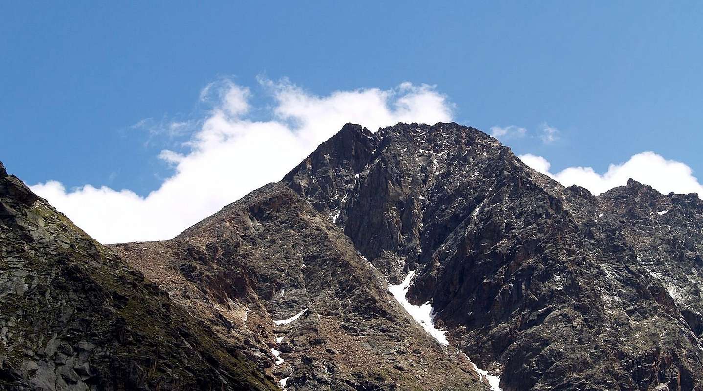
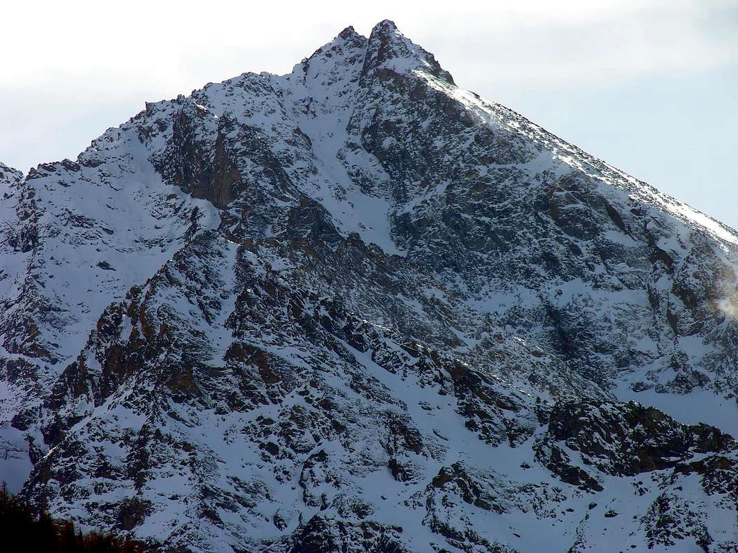
This beautiful mountain remains "clouded" by the presence of the nearby and more famous Great Roise (3.357m), which is the Highest peak of this small mountain range, just to the East of Mount Emilius (3.559m), which gives the same the name. At first glance it might seem like a big shoulder of the same, when in fact it is a completely self-summit which has three ridges and three sides; the first drops of the Pass of Salé or of the Great Roise (formerly Pass of Brissogne; 3.025m) and then get up in the homonymous Becca and conclude with a pointed Tower of the same name. The second falls with lower altitude to the South, and formed an unnamed summit and the twins Summits Gianni Junod or Central Roise (3.300m), reaches the Great Roise. A third ridge descends with greater "grandeur" to the Northeast in the direction of wild Valley of Arpisson (not to be confused with the almost parallel below the North Face of Emilius or with one below the Peak Garin in Cogne Valley); this comes down with a great development, reaching first a flat shoulder or Punta Praborna (3.128m) and lower doubling the Top Vauvire (2.852m). From this last branch descends to the North ending above the Alp of Bonplan (2.382m), while a second, more in the Northeast, the underlying reaches Arpisson Pasture (1.843m), just at the entrance of the walloon of the same name. The walls, however, are basically four, since the uprising in the West is divided in two by a large rocky pillar-"crestone": a face less steep descend towards the West-southwest, couloirs formed by steep rocky-debris; a second falls from Ante Summit North to the North-nordovet with steep rocks and more compact and has not yet risen. The other walls are open to the North over the Basin Arpisson and towards Southeast in the direction of Valley of Saint Marcel (Vauvire Alp); has been the first ascent by a path that goes up the couloir that empties the Northeast Ridge at a shoulder said Point Praborna, while the sector further to the right (West; higher, steep and dangerous) that leads to the Ante Summit North is still a virgin. The second is instead was covered on three occasions, two of them in solitary, through the orographic left side of the rocky canal that runs through the middle. All the walls, however, are dangerous to the fragility of the rock and at the risk of falling rocks. It is almost better to face the same solo, in order to avoid hitting his teammates even with the drag of the rope. Great views of the nearby Emilius with its vertical Wall East, the Central Valley of Dora Baltea and in the distance on the alpine circle that reaches from Mont Blanc, through the entire Pennine Alps with Mont Velan, Grand Combin, Dent des Bouquetins, Dent d'Herens, Matterhorn, Beithorns and Lyskamms, to Monte Rosa.
Questa bella montagna rimane "offuscata" dalla presenza della vicina e più famosa Grande Roise (3.357 m), risultante la Cima più alta di questa piccola catena montuosa, subito ad Oriente del Monte Emilius (3.559 m), alla quale la medesima dà il nome. A prima vista potrebbe sembrar una grande spalla della stessa, mentre in realtà è una Sommità completamente autonoma che presenta tre creste e tre versanti; la prima scende al Colle di Salé o della Grande Roise (anticamente Colle di Brissogne; 3.025 m) per poi rialzarsi nell'omonima Becca e concludere con una torre aguzza dell'identico nome. La seconda scende con minor dislivello verso Sud e, formata una Sommità innominata e le due gemelle Punte Gianni Junod o Roise Centrale (3.300 m), raggiunge la Grande Roise. Una terza cresta discende con maggiore imponenza verso Nordest in direzione del selvaggio Vallone d'Arpisson (da non confondere con quello quasi parallelo sottostante la Parete Nord dell'Emilius o con quello sotto la Punta Garin in Val di Cogne); questa scende con un grande sviluppo raggiungendo dapprima uno spallone piatto detto Punta di Praborna (3.128 m) e più in basso sdoppiandosi alla Punta di Vauvire (2.852 m). Da quest'ultima un ramo scende a Nord terminando sopra l'Alpe di Bonplan (2.382 m), mentre un secondo, più a Nordest, raggiunge la sottostante Alpe d'Arpisson (1.843 m), proprio all'ingresso dell'omonimo vallone. Le pareti, invece, sono in pratica quattro, poiché quella rivolta ad Ovest risulta divisa da un grande pilatro-crestone roccioso: una faccia meno ripida scende verso Ovest-sudovest, formata da ripidi canaloni roccioso-detritici; una seconda cade dall'Antecima Nord più a Nord-nordovest con rocce alquanto ripide e compatte, non risultando ancora salita. Le altre pareti sono rivolte a Settentrione sopra il Bacino d'Arpisson e verso Sudest in direzione del Vallone di Saint Marcel (Alpe di Vauvire); la prima é stata salita con una via risalente il canale che sfocia sulla Cresta Nordest presso lo spallone (Punta di Praborna), mentre il settore maggiormente a destra (Ovest; più alto, ripido e pericoloso) che porta alla Antecima é ancor vergine. La seconda é stata invece percorsa in tre occasioni, delle quali due in solitaria, tramite la sponda orografica sinistra del canale roccioso che la solca nel mezzo. Tutte le pareti, comunque, son pericolose per la fragilità della roccia ed a elevato rischio di caduta di pietre. Perciò, quasi meglio il salirle da solo. Grandi viste sul vicino Emilius con la sua verticale Parete Est, sulla Valle Centrale della Dora Baltea ed in lontananza sulla cerchia alpina delle Pennine, dal Monte Bianco al Rosa.
First Ascents
First on the Top (N Arête with traverse from Brissogne Pass to Grande Roise): Albino Lucat, Angelo Decaroli and Jean Antoine Carrel, (Jul 17th, 1875).
In winter: Unknown.
N- NW Slope and North Crest (Standard Route): Albino Lucat, Angelo Decaroli and Jean Antoine Carrel, (Jul 17th, 1875), in ascent from Arpisson (St. Marcel) Vallon. First repetition: Mountain Guide Grégoire Comé, Agostino Ferrari and E. Quirico (Jun 16th, 1899), in ascent from Le Tramouail (Les Laures) and descent to Arpisson.
North Wall (to Praborna Summit and East Crest): Osvaldo Cardellina, solo, (Aug 22th, 1998), in ascent.
North Wall (HIGH VARIANT on Western Branch directly to Top): Osvaldo Cardellina, solo, (Jul 19th, 2011), in ascent.
North-northeast Ridge (Arpisson Valley): Osvaldo Cardellina, solo, (Aug 22th, 1998). First repetition: Felice Bechon and Diego Margiotta, (Sep 13th, 2001).
Northeast Ridge (from Arpisson Valley to Vauvire Summit): Diego Margiotta, solo, (Oct 05th, 2002), in ascent.
Southeast Wall (Vauvire Alp): Sergio Pession, solo, (Jul 10th, 1983), in ascent. First repetition: Fénis Mountain Guide Maurice Gaillard, solo (July 1983).
South Crest (from Salé Pass with crossing to Grande Roise): Albino Lucat, Angelo Decaroli and Jean Antoine Carrel, (Jul 17th, 1875), in descent.
South Crest (from Leppe Hill with traverse on Grande Roise): Agostino Ferrari and B. Glarey, (Sep 15th, 1898), in ascent.
West-southwest Face (West Couloir): Osvaldo Cardellina, solo, (Jun 16th, 2005), in ascent from Gremonenche-Les Laures Vallon, in day round trip.
West-northwest Pillar (with traverse to Becca and Salé Tower): Osvaldo Cardellina, solo, (Sep 30th, 2007), in ascent.
North-northwest Face (Y Couloir left branch directly to Northern AnteSummit): Osvaldo Cardellina, solo, (Sep 20th, 2011), in ascent from Grand Brissogne through Les Laures Vallon with descent to Col de Salé or of Brissogne also of Grande Roise, Becca di Salé and Tour de Salé, round trip.
North-northwest Face (Y Couloir right branch directly to Top): Osvaldo Cardellina, solo, (Sep 30th, 2011), in ascent from Grand Brissogne-Gremonenche-L'Arp and in descent towards Les Laures Vallon to Grand Brissogne.
Getting There
BY CAR:
From Torino, Milano, etc: Motorway A5. Exit at Aosta Est.
From Switzerland: through the Grand Saint Bernard Tunnel or the namesake Pass. Drive to Aosta.
From France: through Mont Blanc Tunnel or Petit Saint Bernard Pass. It isn't necessary to take Motorway A5: you can drive on SS.26, in the direction of Aosta.
Specific Road: from Exit out of Motorway A5 continue on SS.26
1) - to roudabout of St. Marcel; crossing on great bridge the Dora Baltea reach the center of Municipality; continue South on Regional Road to Les Druges two Villages (brown signal to Servette-Chuc Coppermines and Turati Reserve). Also
2) - continue on State Road up to the Quart-Villefranche Commune; from this turn left (South) and toward a second great bridge above Dora Baltea reach an alternative. Leaving right (West) the Regional Road to Pollein/Charvensod Communes and just after abandoning East various secondaries deviations to St. Marcel Commune, go up a small hill and continue before to the South; crossing Laures Torrent on small bridge, after continue West to Grand Brissogne Municipality.
BY PLANE:
Aeroporto "Corrado Gex" Saint Christophe (Aosta).
Approach
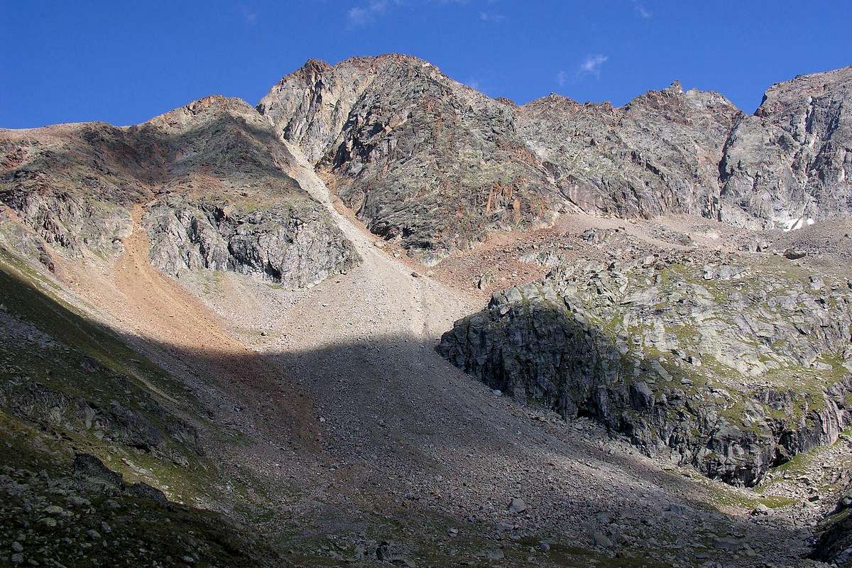
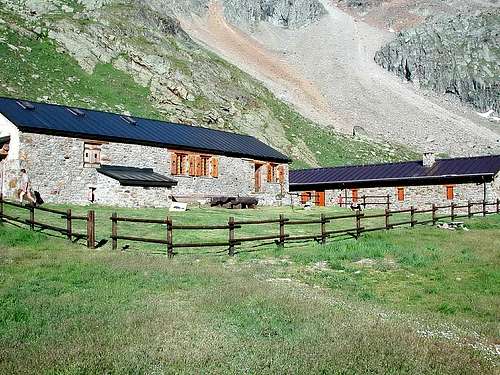
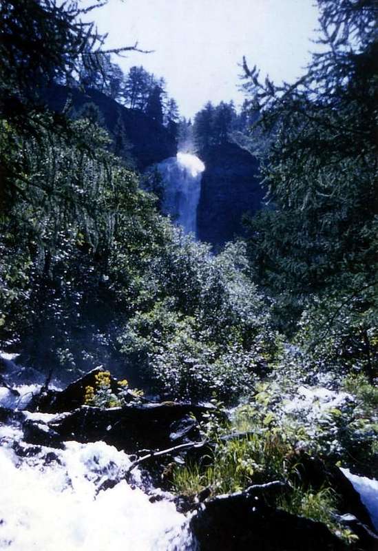
From the Grand Brissogne Municipality (894m), go along the private dirt farms road till the Gremonenche Pasture (1.000m). From here, always along the same reach the l'Arp (1.310m) then, along a good path-muletrack that, bordering the Laures Torrent, leads to La Vieille (1.623m) and to the following Le Tramail or Tramouail (1.951m) (good shelter when weather is bad; always open). Crossing some small bridges up to the altitude of 2.200m, (starting from this point a steep but faster path goes, at right or West, toward the slopes of Becca di Seneva, which then climbs the narrow and small valley at the foot of the same rejoining higher with the muletrack). Better go on toward E forwarding the Becca di Salè (Black Fountains) and climb the last 400 meters on wide slopes till the top of the terraces (2.600m) (here a small chapel built in 1930 and dedicated to Charrey brothers Alessandro said "Dino" and Jean and to companion Cino Norat dead in August 25th, 1929 in an attempt to win the still unclimbed East Wall of Monte Emilius). A short descent leads to the Refuge Ernesto Menabreaz (2.542m, private; has an open free part with blankets, stove and various victuals; usable as winter room, better bring with you a little bit of wood; 8 places), on the Eastern bank of Dessous (Lower) Laures Lake, just neighbor the effluent (small wooden footbridge to Peckoz Pass through path in West).
Important Note: not forgetting the fact that all the climbs in this vallon require a long and exhausting descent to Grand Brissogne; the problem of fatigue becomes even greater if you want to make the ascent in one day sewnza overnight on the Menabreaz Refuge. And yet, when the bad weather comes on the way up to the last, perhaps with fog or snowing so visibility is poor, it is convenient, especially to those not familiar with the area, stopping at Tramouail Upper Alpage even at the preceding La Vieille Pasture.
Dal Comune di Grand Brissogne (894 m) continuare sulla strada poderale per l'Alpe di Gremonenche (1.000 m). Da qui, tramite la medesima, raggiungere l'Arp (1310 m); quindi tramite un bel sentiero mulattiera, accompagnando il corso del Torrent des Laures, risalire a La Vieille (1.623 m) ed al successivo Le Tramail o Tramouail (1.951 m) (ottimo riparo, sempre aperto, in caso di maltempo). Attraversando varii ponticelli fino alla quota di 2.200 metri, (da questo punto risale un sentiero "ripido ma più rapido" verso destra od Ovest verso i pendii della Becca di Seneva, che poi risale l'angusto valloncello ai piedi della medesima ricongiungendosi più in alto con la mulattiera). Meglio proseguire più ad Oriente in direzione delle alte pareti della Becca di Salè (località detta in loco delle Fontane Nere) e risalire gli ultimi 400 metri su ampi pendii fino al colmo dei terrazzamenti rocciosi soprastanti (circa 2.600 metri; dove è stata costruita nel 1930 una piccola cappella dedicata ai fratelli Alessandro detto "Dino" e Jean Charrey ed a Cino Norat morti il 25 di Agosto del 1929 nel tentativo di vincere l'ancora inviolata Parete Est del Monte Emilius). Una breve discesa su sentierucolo in diagonale conduce all'Ernesto Menabreaz (2.542 m, privato ma con una parte libera sempre aperta con coperte, stufa e vettovaglie varie; utilizzabile come riparo d'inverno; 8 posti letto), sulla sponda Est del Lago Inferiore delle Laures.
Nota importante:non trascurare poi il fatto che tutte le salite in questo vallone richiedono lunga ed estenuante discesa fino a Brissogne; la problematica della fatica diventa ancor maggiore qualora si volesse fare la gita in un'unica giornata senza relativo pernottamento. Ed ancora, qualora il brutto tempo arrivasse durante la salita a quest'ultimo, magari con nebbia oppure nevicando e quindi con scarsa visibilità, conviene, soprattutto a chi non é conoscitore della zona, fermarsi al Tramouail se non addirittura a La Vieille.
Route
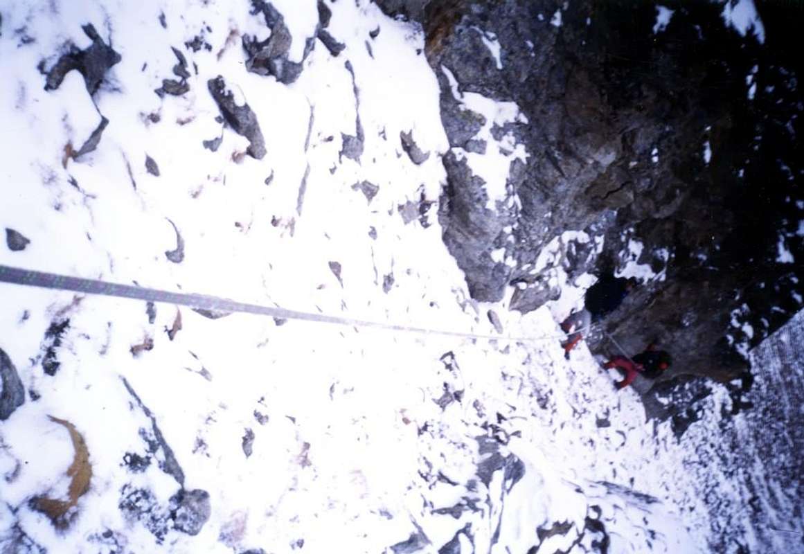
From Refuge Ernesto Menabreaz follow along the path leading to the Lago Lungo di Laures (2.632m); after about a hundred of meters just after the shelter, turn left (East-southeast) toward the Colle della Grande Roise (3.008m), meet in the final part a little couloir that becomes narrower and steepper (better, in the event of snow, keep close the rocks on the right side). Once there climb to the South, at first through fairly obvious traces (numerous signs of passage with droppings ibex) along the North Slope rounded-northwest and then through the easy Northern Ridge formed from very broken and rotten rocks mixed with debris (I°/I°+) to reach the Northern Antesummit (about 3.272 meters), which, after a cut called "Le Pas du Baton" (by local hunters and poachers "Pass Stick", through a short descent on small wall almost vertical ( around ten meters, not very difficult but exposed to East and much delicate wherefore should exercise caution and careful; II°/II°+), leads to the Summit. (2h'10/2h'30) from the Shelter Menabreaz.
Dal Rifugio Ernesto Menabreaz proseguire per breve tratto sul sentiero che conduce al Lago Lungo di Laures (2.632 m); dopo circa un centinaio di metri subito appresso il rifugio, svoltare verso sinistra salendo (Est-sudest) in direzione del Colle della Grande Roise (3.008 m) o di Salé, incontrando nella parte finale un canalino che diventa sempre più angusto e ripido (meglio, in caso di neve fresca, evitarlo appoggiandosi eventualmente sulle nerastre e frantumate roccette a destra). Da questo punto risalire decisamente verso Sud, dapprima tramite tracce abbastanza evidenti (numerosi segni di passaggio con escrementi di stambecchi) lungo l'arrotondato Versante Nord-nordovest ed in seguito, per mezzo della facile nonché breve Cresta Nord. Con questa, formata da rocce molto rotte frammiste a detrito (I°/I°+), raggiungere l'Anticima Nord (3.272 metri circa) che, dopo un intaglio chiamato "Le Pas du Baton" (per i cacciatori ed i bracconieri locali "Passo del Bastone"), tramite una breve discesa su un muretto pressocché verticale (circa dieci metri, non difficile ma piuttosto delicato e molto esposto ad Est per la qual cosa devesi prestare cautela e massima attenzione; II°/II°+), conduce alla Vetta. (2h'10/2h'30) dal Rifugio.
"
Equipment
Expert hiking gear, rope can be useful.
Da alto escursionismo consigliata la corda.
Difficulties
The route is for Expert Hikers with some Alpinistic experience (PD-), but, in the presence of snow is to be assessed in PD+.
L'itinerario è da considerarsi EE/A (PD-), ma in presenza di neve é da valutarsi in PD+.
"Guida delle Alpi Occidentali", di Giovanni Bobba e Luigi Vaccarone C.A.I. Sezione di Torino Volume II (parte II), 25 Maggio 1896.
"80 itinerari di Escursionismo Alpinismo e Sci Alpinismo in Valle d'Aosta", di Osvaldo Cardellina, Ed. Musumeci, Giugno 1977 (in Italian); seconda Ed. Luglio 1981; terza Ed. Luglio 1984; (in French), prima Ed. Febbraio 1978; seconda Ed. Marzo 1980.
"Guida del Monte Emilius", di Osvaldo Cardellina Editore in collaborazione con il Club Alpino Italiano Sezione di Aosta, Dicembre 1978 (in Italian).
"Rifugi e bivacchi in Valle d'Aosta di Cosimo Zappelli", aggiornata da Pietro Giglio, Musumeci Editore, Luglio 2002.
"Guida dei Monti d'Italia–Emilius Rosa dei Banchi Parco del Mont Avic", di Giulio Berutto e Lino Fornelli - Club Alpino Italiano/Touring Club Italiano, Marzo 2005 (in Italian).
"Diari Alpinistici" di Osvaldo Cardellina e Indice Generale accompagnato da Schedario Relazioni Ascensioni 1964-2019 (unpublished).
MAPS:
Kompass "Gran Paradiso Valle d'Aosta Sentieri e Rifugi" Carta Turistica 1:50.000.
Hapax Luglio 2000 "Les Sentiers" Comunità Montana Monte Emilius 1:25.000.
Enrico Editore Ivrea-Aosta "Gruppo del Gran Paradiso" 1:50.000.
I.G.C. Istituto Geografico Centrale Torino "Carta delle Passeggiate ed Escursioni in V.D.A. Conca di Pila-Gressan" 1:20.000.
L'Escursionista Ed. "La Valle di Cogne" 1:25.000.
L'Escursionista Ed. "Tour de la Vallée de Cogne Grand Paradis" Carta dei sentieri 1:25.000.
Parents refers to a larger category under which an object falls. For example, theAconcagua mountain page has the 'Aconcagua Group' and the 'Seven Summits' asparents and is a parent itself to many routes, photos, and Trip Reports.

 5419 Hits
 84.82% Score
 19 Votes
 "
"