
-
 11811 Hits
-
 89.01% Score
-
 28 Votes
|
|
Mountain/Rock |
|---|---|
|
|
45.68850°N / 7.42023°E |
|
|
Mountaineering |
|
|
10292 ft / 3137 m |
|
|
Overview
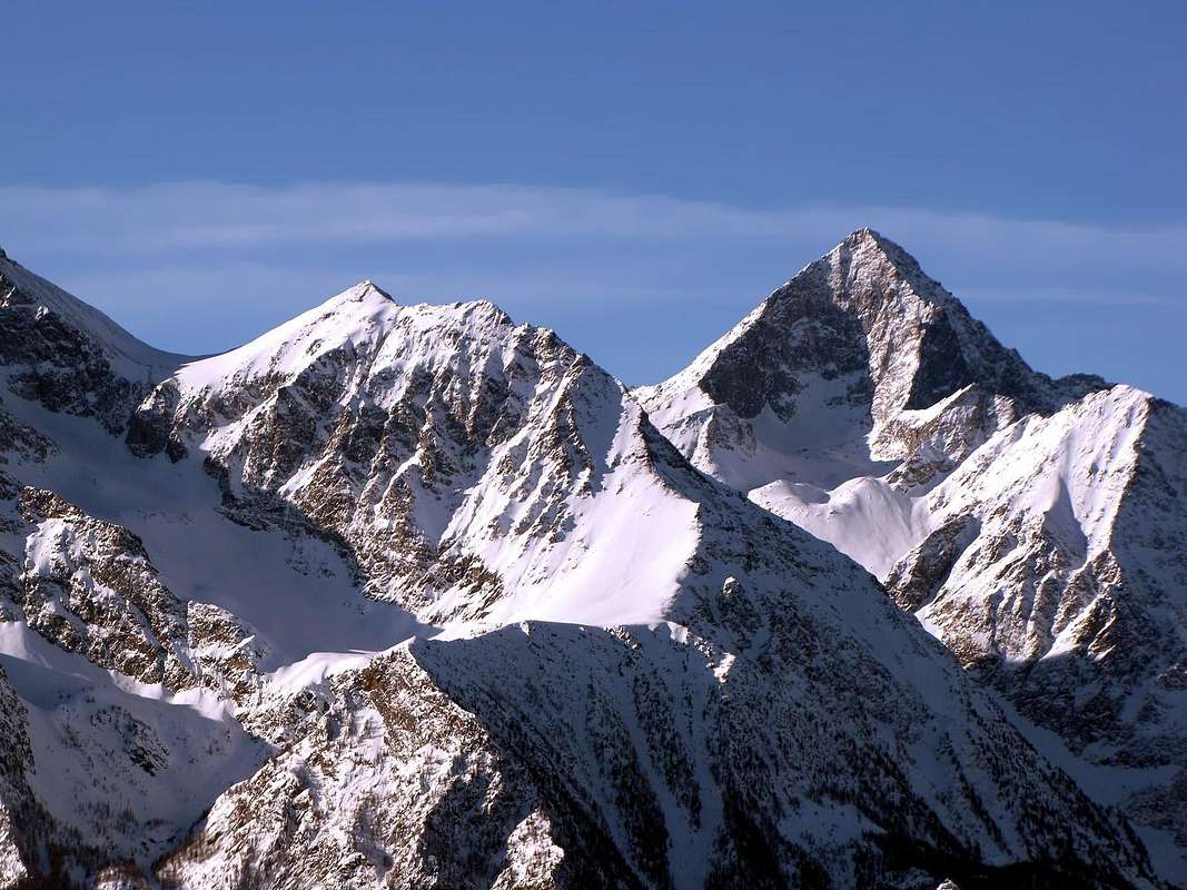
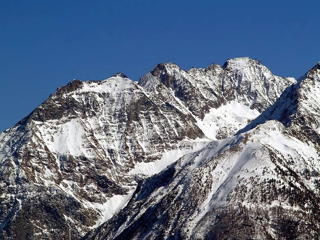
This is a pyramidal shaped mountain, also known as Becca di Nona di Brissogne (previously Mont des Laures), rising at the Northern border of the Gran Roise Group, above Grand Brissogne Municipality. Formed by three ridges with as many sides as is certainly the most visited Summit of the entire Vallon Laures, even more of the same Monte Emilius (3.559m), the highest peak of the same Group. That by virtue of the proximity to the Refuge Menabreaz, as well as the ease of its ascent, but it is not to be underestimated in the presence of snow, especially if you fall recently. Probably frequented by hunters and poachers "ab immemorabilis", knows his first and mountaineering note ascent in 1875 with the rope led by the famous Mountain Guide Valtournanche Jean Antoine Carrel, winner of the Matterhorn "Italian", in the occasion accompanied with Aosta mountaineers Decaroli and Lucat. Its ridges disembarking in the South to the Pass of Salé also known as the Great Roise or Brissogne, to the West by a crest not far outlined adapted to separate the Wall Northwest from the more modest of the Southwest Side, and finally to the North-northeast. This last reaches the first Tour de Salé (3.072m), a great and twin tower immediately to the North, and then down from this with a characteristic shape of a scimitar over the Salé Alp South and the promontory of Selva Plana on the Central Valley Dora Baltea and finally ending with the Top Bonplan and the Cross of Salé (+; 2.382m). The last slope, the Eastern, falls abruptly above the Bonplan last Alp into the wild Vallon of Arpisson in parallel Valley St. Marcel. Among all the ways, however, remains exclusively recommended by the Normal through Pass of Salé be achieved preferably from the slope of the Laures, as opposed on a steep slope of broken rock grooves alternating with soil make the course less accessible and definitely more tiring with a departure from Les Druges very long and devoid of points of support, there being neither shelters and even bivouacs. Not even to consider the approach from the valley floor through the Walloon of Acqua Verde (Green Water), as did the first mountaineers starting even from Saint Marcel; In fact, the steep path diagonal connection with the Arpisson Vallon has almost completely disappeared, and the "hocks" of modern climbers do not compare favorably with those of other times. The only route would be interesting rock Northwest Wall going down in vertical with almost 800 meters above the path that leads to the shelter. Formed by steep rocky plates and slabs is however discontinuous and uneven, and exposed to falling stones; has been crossed only once by the "legendary Agostino" Zulian Luin-Brissogne alone in the mid 60s. An ancient trail connecting, and reported not long ago renovated, the crosses on the basis of the average altitude of 2.600 meters, able to connect to the Pastures of Laures with those of Salé and Bonplan in Arpisson, in memory of a transit livestock high share that no longer exists. Now is addressed only to Hikers, the most courageous and enterprising because the path is quite "adventurous". The other ways are to be avoided because dangerous or layers grass on the rocks (West Ridge, which could be a variant starting from the refuge) or because they consist of very broken rock with a danger of falling rocks (all the East Slope and the nearby North-nordest). A beautiful journey that is along the North-northeast Ridge, interesting in the final part, that reaches the Tour de Salé, certainly very scenic, but also long. Tower the same can be achieved more quickly in the opposite direction with a short descent from Becca of Salé to the North and lifts along the same route. In any case, the primary advice is still valid, except that does not make any lover of exploration further research: there is always something new, it is sufficient to look outside of the "common routes". No walk in the footsteps of other. Very fine panoramic point on the main Aosta Valley and almost all the main Summits of the whole Aosta Valley, with splendid view in foreground on Emilius vertical East Wall.
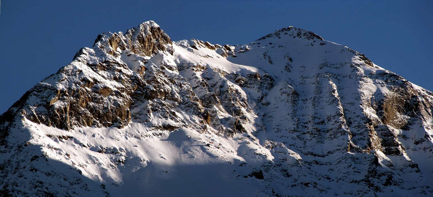
Montagna di forma piramidale conosciuta anche come Becca di Nona di Brissogne, o, in altri tempi, Mont des Laures; s'erge all'estremità Settentrionale del piccolo Gruppo della Grande Roise, sopra il Comune di Grand Brissogne. Formata da tre creste con altrettanti versanti risulta sicuramente come la Sommità maggiormente visitata dell'intero Vallone delle Laures, più ancora dello stesso Monte Emilius (3.559 m), vetta più elevata dello stesso Gruppo. Ciò in virtù della vicinanza al Rifugio Menabreaz, nonché alla facilità della sua salita, che però non é da sottovalutarsi in presenza di neve, soprattutto se caduta di recente. Probabilmente frequentata da cacciatori e bracconieri "ab immemorabilis", conosce la sua prima salita alpinistica e nota nel 1875 con la cordata condotta dalla famosa Guida di Valtournanche Jean Antoine Carrel, il vincitore del Cervino "italiano", nell'occasione accompagnato dagli alpinisti aostani Decaroli e Lucat. Le sue creste scendono rispettivamente a Sud verso il Colle di Salé detto anche della Grande Roise o di Brissogne, ad Ovest con una cresta non molto delineata atta a separare la Parete Nordovest dal più modesto Versante Sudovest ed infine a Nord-nordest. Quest'ultima raggiunge dapprima la Tour de Salé (3.072 m), un grosso torrione gemello subito a Nord, per poi scender da questo con una caratteristica forma a scimitarra sopra l'Alpe di Salé a Sud ed il promontorio di Selva Plana sulla Valle Centrale della Dora Baltea ed infine concludersi con la Punta di Bonplan e la Croce di Salé (+; 2.382 m). L'ultimo Versante, quello Orientale, cade abrupto sopra il selvaggio Vallone di Arpisson e l'Alpe di Bonplan nella parallela Valle di St. Marcel. Tra tutte le vie rimane però consigliabile esclusivamente la Normale dal Colle di Salé da raggiungersi preferibilmente dal versante delle Laures, poichè sull'opposto un ripido pendio di rocce rotte alternate a canalini con terriccio rendono il percorso meno agibile e sicuramente più faticoso con una partenza da Les Druges molto lunga e priva di punti d'appoggio, non essendovi né rifugi e neppure bivacchi. Neanche da prendere in considerazione l'approccio dal fondovalle tramite il sottostante Vallone dell'Acqua Verde, come fecero i primi salitori partendo addirittura da Saint Marcel; infatti il ripido sentiero diagonale di collegamento con il Vallone dell'Arpisson é quasi del tutto scomparso ed i "garretti" degli alpinisti moderni non reggono il confronto con quelli d'altri tempi. L'unica via di roccia interessante potrebbe consistere in quella della Parete Nordovest discendente con quasi 800 metri di dislivello sopra il sentiero conducente al rifugio. Formata da placche e "piatte" rocciose molto ripide risulta però discontinua e poco omogenea, nonché esposta alla caduta di pietre; é stata percorsa un'unica volta dal "mitico Agostino" Zulian di Brissogne-Luin da solo a metà degli anni'60. Un antico sentiero di collegamento, segnalato e da non molto tempo ristrutturato, l'attraversa alla base all'altitudine media di 2.600 metri, atto a collegare gli alpeggi delle Laures con quelli di Salé e Bonplan nell'Arpisson, a ricordo d'un transito del bestiame ad alta quota oggi non più esistente. Ormai é rivolto esclusivamente agli Escursionisti, quelli più coraggiosi ed intraprendenti poiché il percorso risulta abbastanza "avventuroso". Le altre vie sono da evitarsi perchè o pericolose per gli strati erbosi sulle rocce (Cresta Ovest, che potrebbe costituire una variante partendo dal rifugio) oppure perché formate da roccia molto rotta con pericolo di caduta di pietre (tutto il Versante Est e l'attiguo Nord-nordest). Una bella traversata risulta quella lungo la Cresta Nord-nordest, interessante nella parte finale, raggiungente la Tour de Salé, sicuramente molto panoramica, ma altresì lunga. Si può pervenire alla stessa in più breve tempo nel senso opposto con corta discesa dalla Becca di Salé verso Nord e risalita lungo la medesima via. In ogni caso rimane valido il consiglio primario tranne che qualche amante dell'esplorazioni non effettui altre ricerche: qualcosa di nuovo sempre si trova. Bellissimo punto panoramico sulla Valle Centrale e su quasi tutte le principali montagne dell'intera regione valdostana, con splendida vista affronte sulla verticale Est dell'Emilius.
First Ascents
- First on the summit: Albino Lucat, Angelo Decaroli and Jean Antoine Carrel, (Jul 17th, 1875).
- In Winter: Unknown.
- South Crest (Standard Route from Salé Pass): Albino Lucat, Angelo Decaroli and Jean Antoine Carrel, (Jul 17th, 1875) in ascent from St. Marcel Municipality and along the Arpisson Vallon.
- West Crest (from Lower Laures Lake): Osvaldo Cardellina, lone, (Nov 23th, 2006), in ascent from Gremonenche Alp, Les Laures Vallon Dessous Lake.
- NW Wall (Right Sector): Giovanni Matteo "Agostino" Zulian, lone (half Years '60), in ascent from Gr. Brissogne through L'Arp, La Vieille, Le Tramouail Alps.
- East Face (Southern or of Left Central Rib directly to Top): Osvaldo Cardellina, lone (May 22th, 2005), in ascent from Les Druges Tall, Arpisson Vallon.
- East Face (Northern or of Right Central Rib directly to Top): Osvaldo Cardellina, lone (Oct 27th, 2011), in ascent from Les Druges Alte, Arpisson Vallon.
- N Arête (from Tour de Salè): Osvaldo Cardellina, lone (Sep 23th, 2007), in ascent from Pouria Alp, Arpisson Vallon to Salé Alp.
- N Arête (to Tour de Salè): Osvaldo Cardellina, lone (Sep 30th, 2007), in descent round trip from Petite Roise towards Becca di Salé.
- W Face (of Tour de Salè): Osvaldo Cardellina, lone (Jun 26th, 2008), with traverse to Becca di Salé and Petite Roise, Gran Brissogne.
- Eastern Face (of Tour de Salè) between third and fourth rocky ribs): Osvaldo Cardellina, lone (Oct 30th, 2011), fron Vargney/Roquillod Pastures, Servette, Eteley, fork 1836m nearby Choulet Alpage towards Arpisson Vallon, Salé and Bonplan Alps with traverse to Becca di Salé and Petite Roise through Northern Slope, Gr. Brissogne.
Getting There
BY CAR:
- From Torino, Milano, etc: Motorway A5. Exit at Aosta Est.
- From Switzerland: through the Grand Saint Bernard Tunnel or the namesake Pass.
- From France: through Mont Blanc Tunnel or Petit Saint Bernard Pass. It isn't necessary to take Motorway A5: you can drive on SS.26, in the direction of Aosta.
Specific Road: from Exit out of Motorway A5 continue on SR.26
1) - to roudabout of St. Marcel; crossing on great bridge the Dora Baltea reach the center of Municipality; continue South on Regional Road to Les Druges two Villages (brown signal to Servette-Chuc Coppermines and Turati Reserve). Also
2) - continue on State Road up to the Quart-Villefranche Commune; from this turn left (South) and toward a second great bridge above Dora Baltea reach an alternative. Leaving right (West) the Regional Road to Pollein/Charvensod Communes and just after abandoning East various secondaries deviations to St. Marcel Commune, go up a small hill and continue before to the South; crossing Laures Torrent on small bridge, after continue West to Grand Brissogne Municipality.
BY PLANE:
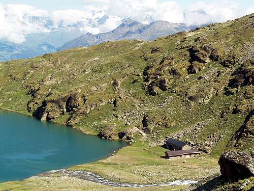
Approach A From the Grand Brissogne (894m), go along the private farm road till the Gremonenche Pasture (1.000m). From here along the dirt road up to l'Arp (1.310m) then, along a path n°1 that, bordering the Torrent des Laures), leads to La Vieille (1.623m) and to Le Tramail or Tramouail (last or more high pasture; 1.951m) (good shelter when weather is bad). Crossing some small bridges up to the altitude of 2.200m, (starting from this point a steep but faster path n° 1A goes, at right or West, toward the slopes of Becca di Seneva). Better go on toward East forwarding the Becca di Salè (zone called "Black Fountains" by the inhabitants) and climb the last 400 meters on wide slopes till the top of the overhanging rocky terraces (2.600m) (small chapel dedicated to Charrey brothers and Cino Norat dead in 1929 on the East Wall of Emilius). A short descent to the Southeast leads at Refuge Ernesto Menabreaz (2.542m, private), the same has an open free part (with wood-burning stove) usable as winter room (8 places with covers), on the East bank of Lago Inferiore di Laures (3h'30/4h'00).
Avvicinamento A Da Grand Brissogne (894 m), percorrere la strada poderale fino all'Alpe di Gremonenche (1.000 m). Da qui proseguire lungo la strada sterrata fino a l'Arp (1.310 m) ove ha termine; poi continuare, tramite il sentiero n° 1 che in alto si trasforma in mulattiera, al di sopra del Torrente des Laures, portando a La Vieille (1.623 m) e Le Tramail (1.951 m; buon riparo quando il tempo è cattivo). Attraversando alcuni ponticelli fino alla quota di 2.200 metri circa, (a partire da qui un sentierino n°1A ripido ma più veloce va, a destra od Ovest, verso le pendici della Becca di Seneva). Meglio procedere verso Est contro la Parete Nordovest della Becca di Salè (luogo soprannominato "delle Fontane Nere") ed affrontare gli ultimi 400 metri su ampi pendii fino ad una zona di terrazze rocciose soprastanti (2.600 m; qui esiste una piccola cappella dedicata ai fratelli Charrey ed a Cino Norat morti nel 1929 sulla Est dell'Emilius). Una breve discesa a Sudest porta al Rifugio Menabreaz (2.542 m; privato); il rifugio possiede una parte libera aperta (con stufa a legna, in genere presente in loco) utilizzabile come locale invernale (8 posti nei letti a castello ed inoltre coperte e vettovagliamento), sulla sponda Est del Lago Inferiore (3h'30/4h'00).
 |
 |
 |
 |
 |
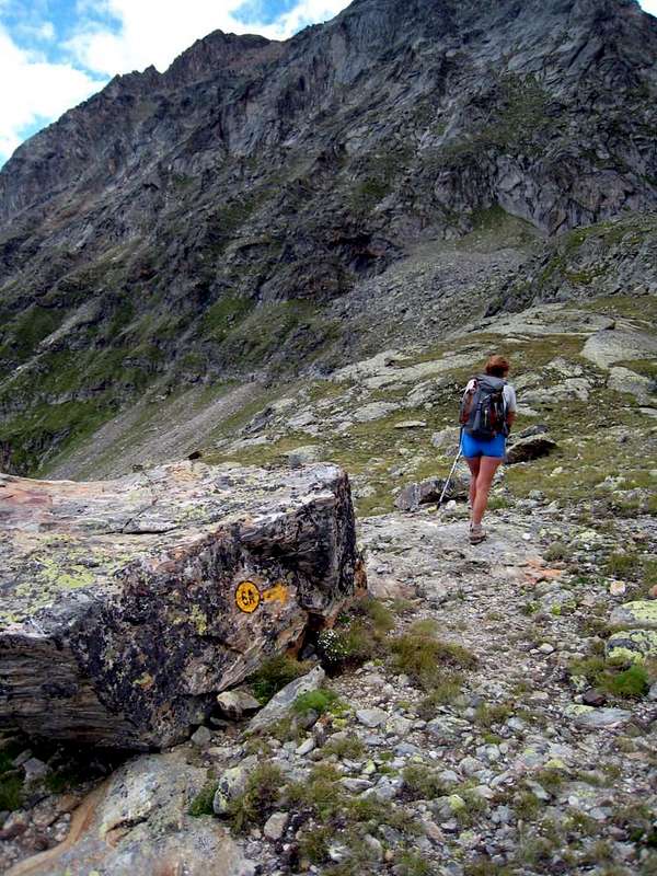
Route A From Refuge Ernesto Menabreaz, neighbor the Dessous (Lower) Laures Lake, follow along the path leading to the Lago Lungo di Laures (2.632m); after about a hundred of meters turn left (Northeast) towards a clear reddish scree below the Salé Pass also called in old times Colle della Grande Roise, even "Colle di Brissogne" (3.008m), meet in the final part a little couloir that becomes narrower and steepper (keep close, especially in case of the presence of fresh snow, possibly to the rocks on the right side or South). Once there climb toward North, through a small track on soil, the easy South Crest to the Summit. This is the route followed on the first ascent in 1875. (1h'30 from the Refuge).
Via A Dal Rifugio Ernesto Menabreaz proseguire per breve tempo sul sentiero che conduce al Lago Lungo di Laures (2.632 m), dopo circa un centinaio di metri, svoltare verso Nordest in direzione di una evidente pietraia rossiccia sottostante al Colle di Salé detto pure della Grande Roise od anche "di Brissogne (3.008 m), incontrando nella parte finale un canalino che diventa sempre più angusto e ripido (appoggiarsi, soprattutto in caso di presenza di neve fresca, eventualmente sulle roccette a destra o Sud). Da qui risalire verso Nord, tramite una piccola traccia di passaggio sul terriccio, la facile cresta Sud che conduce alla Vetta. (1h'30 dal Rifugio). Questa é anche la via tenuta nella prima ascensione nel 1875.
Approach B From Saint Marcel, always along the S-SE Arête: from Les Druges Alte, locality Pouria (1.600m); various panels) starting from the small lay-by beyond the dump of the above abandoned copper mine Chuc-Servette (1.810, 1.720 meters: various entrances and remains), and after rounding the cape entering the real valley, walk "suspended" on the left (East) along the whole Valley of Saint Marcel and, after passing a small gate, border of the Reserve by Marquis Turati ex Baron Peckoz, and after a short descent, remount passing through Eteley Pasture (1.741m). Continue on dirt road, concomitant with the path n° 3/4 reaching the alternative 1.836 meters, boarding on the right the manganese old Mine of Praz Bornaz also Praborna (the entrance about 1.900 meters; abandoned for years now). From this point, just before the next junction which leads to Praborna Pasture, and completely reverse direction through the path n° 4G, go back to the North-northwest, reaching the Choulet Alpage (1.821m; formerly La Chaz); continue with the next long diagonal, leaning more to the Northwest, with the steepest path reaches a small basin. Reached the point 1.929 meters and through decidedly path to the North you will come to a small collar of about twenty meters high, just to the West of an small promontory with Cross and at the real entrance above the Arpisson Vallon.
NOTE: an ancient path, now nearly completely disappeared, reached in crossing with short descent from the Alp Vauvire (2.103m) to this small collar. At the same it came or from Praborna (1.882m) with path-mule-track still exist, or through a grueling journey, starting even from just below Chaux Grande Hunting House (2.370m) and just beyond the Lac Layet, reached in succession the Alps Crêtonaz and Rualla (2.348, 2.359 meters and the small basin, between the two altitudes 2.354m, 2.334m) at the base of the East Wall of Great Roise (3.357m). From here the trail turns into a small little obvious trace reaching down Vauvire. This route is now almost exclusively traveled by the Gamekeepers Turati's Preserve and requires knowledge of the area to be followed, for this reason we do not recommend this route, however, striking that requires adequate accompaniment. From the collar, leaving in bottom and right the path down to Alp Arpisson (1.830m), on the other hand continue Westward and crossed a creek secondary which later gives rise to the wild Torrent of Arpisson, with semi-circular path in the last part reach the lonely hemi abandoned Salé Alp, placed under the eponymous Cross (2.209m; 3h'15/3h'30).
Avvicinamento B Da Saint Marcel, sempre lungo la Cresta Sud-sudest: da Les Druges Alte, località Pouria (1.600 m; cartelli varii), a partire dalla piccola piazzola al di là della discarica dell'abbandonata miniera di rame Chuc-Servette, e dopo aver doppiato il promontorio entrando nel vero e proprio vallone, camminare "sospesi" sulla sinistra (Est) quasi lungo l'intera Valle di Saint Marcel e, dopo aver superato un cancelletto, confine della Riserva di proprietà del Marchese Turati ex Barone Peckoz, e dopo una breve discesa, rimontare passando dall'Alpe di Eteley (1.741 m). Continuare tramite la medesima sterrata concomitante con il sentiero n° 3/4 raggiungendo il bivio 1.836 metri con immediatamente sulla destra l'antica miniera di manganese (abbandonata ormai da molti anni) di Praz Bornaz. Da questo punto, appena prima del successivo bivio che conduce a Praborna, invertire completamente direzione e, tramite il sentiero n° 4G, risalire verso Nord-nordovest raggiungendo l'Alpe di Choulet (1.821 m; anticamente La Chaz); continuare con il successivo lungo diagonale che, poggiando maggiormente a Nordovest, con percorso più ripido raggiunge una piccola conca. Raggiunto il punto 1.929 metri e tramite percorso decisamente a Settentrione si perviene ad un colletto d'una ventina di metri più elevato, subito ad Ovest d'un promontorio con una Croce ed al vero ingresso del Vallone dell'Arpisson.
NOTA: un antico sentiero, ormai quasi completamente scomparso, raggiungeva in traversata con corta discesa dall'Alpe di Vauvire (2.103 m) questo colletto. Alla medesima si arrivava o da Praborna (1.882 m) con sentiero-mulattiera ancora esistenti, oppure tramite una estenuante traversata che, partendo addirittura da appena sotto Grande Chaux (2.370 m) e subito oltre il Lac Layet, raggiungeva in successione le Alpi di Crêtonaz e Rualla (2.348 m, 2.359 m) ed il piccolo bacino, compreso tra le due altitudini 2.354 m, 2.334 m) alla base della grande Parete Est della Grande Roise (3.357 m). Da qui il piccolo sentiero si tramuta in una poco evidente traccia raggiungendo in discesa l'Alpe Vauvire. Questa via viene ormai quasi esclusivamente percorsa dal Guardiacaccia della Riserva e richiede conoscenza del territorio per essere seguita, perciò la si sconsiglia se non accompagnati. Dal colletto, lasciando in basso e a destra il sentiero che scende all'Alpe di Arpisson (1.830 m), continuare invece verso Ovest ed, attraversato un torrente secondario che in seguito dà origine al selvaggio Torrente di Arpisson, con percorso semicircolare nell'ultima parte raggiungere l'Alpe di Salé, posta sotto l'omonima Croce (2.209 m; 3h'15/3h'30).
 |
 |
 |
 |
 |
Route B
![]()
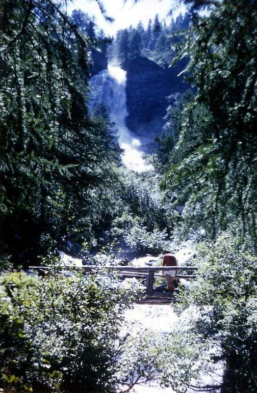
"On the path crossing from Les Laures towards Arpisson Vallons"
MAPS:
From the Alp of Salé continue to the West with a wide bend in the path of connecting with Les Laures, but arrived in altitude (2.341m), at the junction of two small torrents, leave the same; go instead to the South via a track leading to the Alp of Bonplan (2.374m). This is situated near the end of the North-northeast Ridge that descends from Petite Roise (3.279m) or, more precisely, from Pointe de Praborna (3.128m), doubling itself in altitude 2.873 meters, as well as a seedy vallon that goes back in the direction of the first. Climb through scree and "clapeys" or large blocks reaching a height of 2.763 meters above the terminal parts of the ancient Glacier Littlee Roise, now in effect "permafrost" and reduced to glacial-snowfield below its North Face. Sharpening the view, you can still see the miserable remains of a more high and ancient alp; abandoning the Southbound and turning decidedly to the West, you reach the point 2.934 meters just north of the vertical drops from the large and rounded saddle which is the Hill of Salé (3.008m). This rock band, high eighty meters allows several steps between small rock outcrops alternate with grooves soil; should grab the one on the South, that with rising diagonally left/right, leads easily to the hill as the result of a bottom-analysis. In any case, be careful to avoid falling stones of the same move over who is behind (2h'20/2h'50 Salé). (***) This route is completed very well combining the descent on Laures and then back through the path 6A/4G of the link, making a impressive ride back to Les Druges.
Via B Dall'Alpe di Salé continuare verso Ovest con un largo tornante sul sentiero di collegamento con Les Laures, ma giunti in quota 2.341 metri, presso la congiunzione di due torrentelli, abbandonare il medesimo; dirigersi invece verso Sud tramite una traccia che conduce all'Alpe di Bonplan (2.374 m). Questa é collocata nelle vicinanze della parte terminale della Cresta Nord-nordest discendente dalla Petite Roise (3.279 m) o, più precisamente, dalla Punta di Praborna (3.128 m), sdoppiandosi a sua volta a quota 2.873 metri, nonché di uno squallido valloncello che risale in direzione della prima. Salire tramite pietraie e "clapeys" o grossi blocchi raggiungendo a quota 2.763 metri le parti terminali dell'antico Glacier della Petite Roise, oggi in effetto "permafrost" e ridotto a glacio-nevaio al di sotto della sua Parete Nord. Aguzzando la vista, si vedon ancora i miseri resti d'un alpe più elevata ed antica; abbandonando la direzione Sud e volgendo decisamente ad Ovest, si raggiunge il punto 2.934 metri subito a Nord della verticale che scende dall'ampia ed arrotondata sella costituente il Colle di Salé (3.008 m). Questa fascia rocciosa, alta una ottantina di metri consente diversi passaggi tra piccole costole rocciose alternate con canalini di terriccio; conviene afferrare quello più a Mezzogiorno contro la Petite Roise che, con salita in diagonale dalla sinistra alla destra, porta più facilmente al colle di quanto non appaia da un analisi dabbasso. In ogni caso prestar attenzione alla caduta di pietre evitando di smuovere le stesse sopra chi segue (2h'20/2h'50 dall'Alpe di Salé). (***) Questo itinerario si completa bene scendendo con la Via A e rientrando all'Arpisson tramite il sentiero di collegamento 6A/4G, compiendo un giro altamente suggestivo.
Difficulties
This is a hiking route - difficulty E/F to the Route A, EE/A/F+ for the itinerary B.L'itinerario è considerato escursionistico E/F per la Via A, EE/A/F+ nei confronti dell'itinerario B.
 |
 |
 |
Other Ways ranging from PD- to D.
Da Escursionismo.
Huts
|
Campings
Remember that free camping is forbidden (except for emergency reasons, over 2.500m, from darkness until dawn).Mountain Condition
- You can get meteo information at the official site of the Regione Valle d'Aosta:
- Valle d'Aosta Meteo
Webcam
- WEBCAM on Aosta Valley:
- Webcam
Books and Maps
BOOKS:- "Guida delle Alpi Occidentali" di Giovanni Bobba e Luigi Vaccarone C.A.I. Sezione di Torino Volume II (parte II), 25 Maggio 1896.
- "Guida del Monte Emilius" di Osvaldo Cardellina Editore in collaborazione con il Club Alpino Italiano Sezione di Aosta, Dicembre 1978 (in Italian).
- "Guida dei Monti d'Italia – Emilius Rosa dei Banchi-Parco del Mont Avic" di Giulio Berutto e Lino Fornelli - Club Alpino Italiano/Touring Club Italiano, Marzo 2005.
- "Diari Alpinistici" di Osvaldo Cardellina e Indice Generale accompagnato da Schedario Relazioni Ascensioni 1964-2019 (unpublished).

|

|

|

|
- Kompass "Gran Paradiso Valle d'Aosta Sentieri e Rifugi" Carta Turistica 1:50.000.
- Hapax "Les Sentiers" Comunità Montana Monte Emilius, Luglio 2000 1:25.000.
- L'Escursionista "Conca di Aosta-Pila-Monte Emilius" Carta dei sentieri (n° 4) 1:25.000.
- Enrico Editore Ivrea-Aosta "Gruppo del Gran Paradiso" 1:50.000.
- L'Escursionista "Valle di Cogne" Carta dei Sentieri 1:25.000.
- Hapax "Les Sentiers de Charvensod" Comune di Charvensod, Giugno 2003 1:25.000.
Important Information
- REGIONE AUTONOMA VALLE D'AOSTA the official site.
- FONDAZIONE MONTAGNA SICURA Villa Cameron, località Villard de la Palud n° 1 Courmayeur (AO) Tel: 39 0165 897602 - Fax: 39 0165 897647.
- A.I.NE.VA. (Associazione Interregionale Neve e Valanghe).
Useful numbers
- Protezione Civile Valdostana località Aeroporto n° 7/A Saint Christophe (Ao) Tel. 0165-238222.
- Bollettino Meteo (weather info) Tel. 0165-44113.
- Unità Operativa di Soccorso Sanitario Tel. 118.