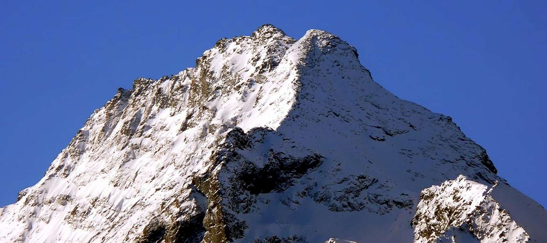
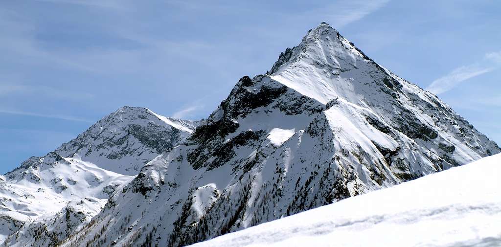
From Mont Glacier (3.186m), toward NNW, starts a big buttress that, after descending to the Eyelé Pass (2.812m), rises again in the huge rampart of Rafray, the one that divides in two different sectors the Fénis Valley. Formerly known as Pointe des Chamois, this summit is rarely climbed. Fine views upon the Mont Glacier, Mont Delà, Mont Avic and the big Tersiva (3.515m).
Dal Mont Glacier (3.186 m) si diparte a N-NW un contrafforte che, dopo essersi abbassato al Colle dell'Eyelé (2.812 m), si rialza nell'imponente bastionata del Rafray; la stessa separa il Vallone di Fénis in due distinti settori. Chiamata anticamente anche Pointe des Chamois, è raramente salita. Belle le vedute sul Mont Glacier, Mont Delà, Mont Avic e l'imponente Tersiva (3.515 m).
First Ascents
First on the summit: Nicola Vigna, Carlo Ratti and Giulio Toesca, (Aug 21th, 1900), in descent from Mont Glacier, Fussì and Etsely Passes.
In winter: Unknown.
S-E Arête: Nicola Vigna, Carlo Ratti and Giulio Toesca, (Aug 21th, 1900), in ascent from Etsely Pass.
W-SW Great Couloir: Osvaldo Cardellina, solo, (Sep 21th, 2003), in ascent from Etsely Alp.
SW Slope (Right Rib to Central Summit): Emilio Bertona and Gianfranco Vicentini, (Sep 21th, 2003), in ascent from Le Tramouail.
S-SW Face (to South Ante Summit): Osvaldo Cardellina, lone, (May 03th, 2007), in ascent from Le Tramouail d'Etsely; in descent S-E integral Arête to Etsely, Etseley or Echelly Col, Etseley Pasture, Grand'Alpe towards Meney, Maison Blanche, Robbio, Marqueron, Lovignana, Barche Alpages.
E-NE Edge (to South Ante Top): Osvaldo Cardellina, lone, (Aug 08th, 2005), in ascent from Lovignana, Marqueron, Robbio, Maisonnasse, Maison Blanche, Baiette, Orgère, Mezove Alp and Margheron Loch; in descent through SW Crest to Le Tramouail d'Etsely, crossing the Eyelé or E'chelly Pass to lake.
E-NE Wall (Central Couloir to Northern Summit): Osvaldo Cardellina, solo, (Aug 29th, 2005), in ascent from Barche, Lovignana, Robbio, Maison Blanche, Baiette, Orgère, Alp 2.129 meters; in descent along SW Ridge towards Le Tramouail d'Etsely, l'Eyele Alp, Grand Alpe to Val Fénis-Clavalité Tableland.
N-NE Face (Left Channel to Summit Crest between South/North Summits): Osvaldo Cardellina, solo, (Aug 01th, 2006), in ascent from Barche/Lovignana, Robbio, Maison Blanche, Baiette, Orgère, Alp 2.129 meters; in descent along SW Ridge to Le Tramouail d'Etsely, l'Eyele Alp, Grand Alpe, Val Fénis-Clavalité.
NW Face (to North Summit): Osvaldo Cardellina, lone, (Jun 07th, 2007), in ascent from dirt road before Meney Alp.
Getting There
BY CAR:
From Torino, Milano, etc: Motorway A5. Exit Nus Village for Fénis Village.
From Switzerland: through the Grand St. Bernard Tunnel or the homonym Pass. Drive to Aosta, for Nus and Fénis.
From France: through Mont Blanc Tunnel or Petit St. Bernard Pass. It isn't necessary to enter in Motorway A5, you can drive through SS.26 Aosta direction. Exit Nus Village and Fénis.
BY PLANE:
Aeroporto "Corrado Gex" Saint Christophe (Aosta).
Route
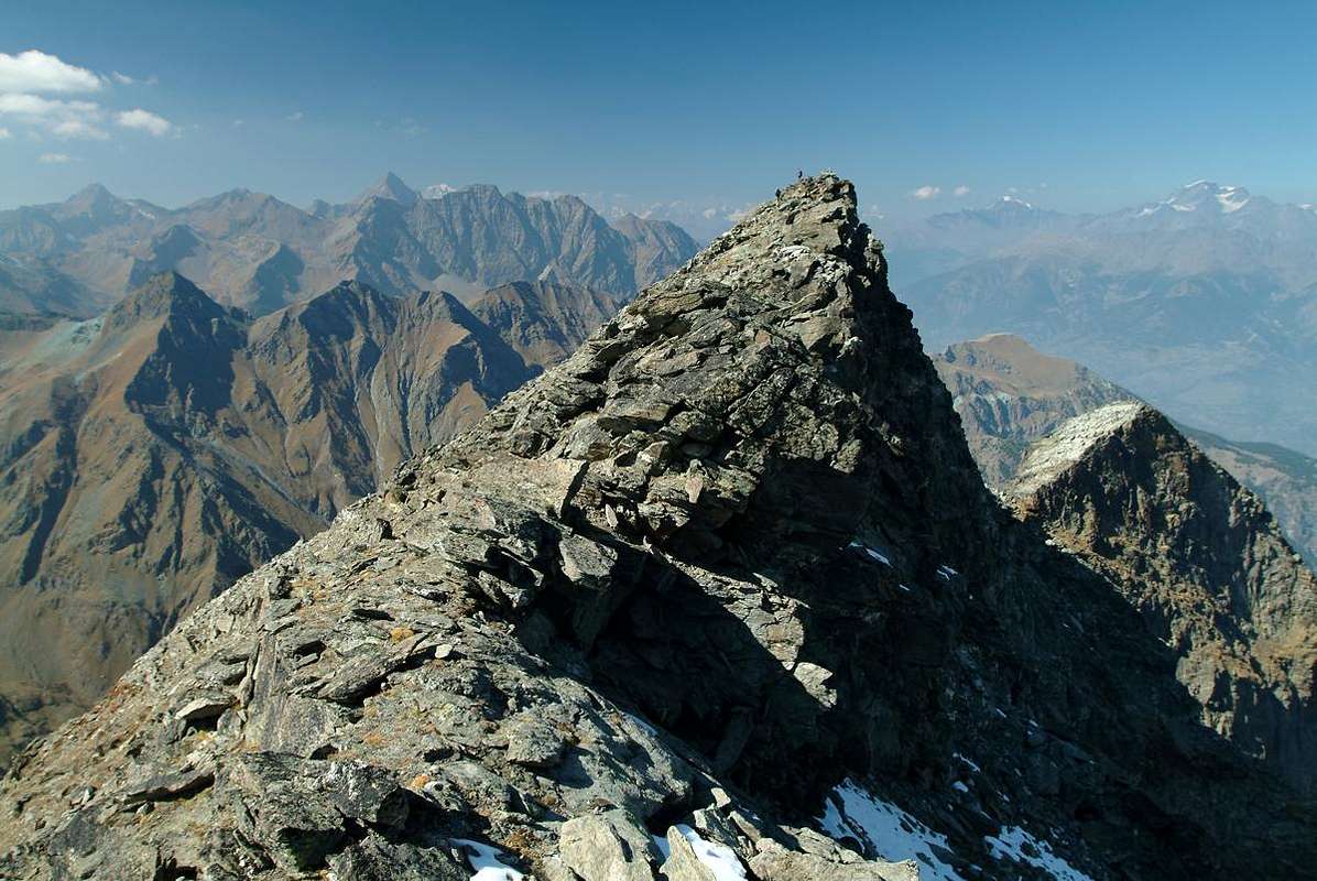
From Fénis (Barche - 607m) along the dirt road (no access mark), after Lovignana (1.162m - 9km) that, boarding the Clavalitè Stream ascends the whole valley up to the Baite di Grand Alpe (2.120m), at the beginning of the Comba Tersiva, under the Colle di Fénis (2.857m). From the pastures toward East along the path n° 102 up to the Cuneu stabling buildings (2.156m) near the new Bivouac E. Borroz. On again to the Pastures of Etsely Damon (2.434m), cross a small valley and continue to N on small tracks to gain the rocky bend in the low part of the SW ridge that must be overtaken at about 2.550m. The ridge, first bordering a Y channel on rocks and scree, leads to the Southern Minor Summit (3.092m); on along the sharp edge going around, using the ledges on the W side, some small towers and, after passing the Central Summit (3.109m), you arrive to the sign on the top (6h'30/7h'00).
Da Fénis, località Barche (607 m), percorrere la lunga strada poderale (palina di divieto dopo Lovignana; 1.162 m, a 9 km) che, costeggiando il Torrente Clavalitè, risale l'intera omonima valle sino alle Baite di Grand Alpe (2.120 m), all'inizio della Comba Tersiva, sottostante il Colle di Fénis (2.857 m). Dall'Alpeggio seguire verso est il sentiero intervallivo n° 102 fino alle soprastanti Baite di Cuneu (2.156 m), presso le quali è stato da poco edificato il Bivacco E. Borroz. Continuare a salire fino all'Alpeggio d'Etsely Damon (2.434 m); oltrepassare un avvallamento, indirizzandosi verso N su lievi tracce di sentiero fino a raggiungere una fascia di rocce alla base della cresta SW e scavalcarla sui 2.550 metri. La stessa, fiancheggiando dapprima un canale a "Y" su rocce e pietraie conduce all'Antecima Sud (3.092 m); percorrere il tagliente aggirando alcuni piccoli torrioni su cenge ad ovest e, superata la Cima Centrale (3.109 m), sempre in direzione NW si raggiunge il segnale posto sulla vetta (6h'30/7h'00).
Difficulty
This route is rated EE/A, F+.
L'itinerario è classificato EE/A, F+.
Gear
Standard mountaineering equipment.
Da alpinismo.
Campings
Remember that free camping is forbidden (except for emergency reasons, over 2.500m, from darkness until dawn).
Mountain Conditions
You can get meteo information at the official site of the Regione Valle d'Aosta:
"Guida delle Alpi Occidentali" di Giovanni Bobba e Luigi Vaccarone C.A.I. Sezione di Torino Volume II (parte II), 25 Maggio 1896.
"Guida dei Monti d'Italia – Emilius Rosa dei Banchi-Parco del Mont Avic" di Giulio Berutto e Lino Fornelli - Club Alpino Italiano/Touring Club Italiano, Marzo 2005.
"Guida della Regione Autonoma Valle d'Aosta" di Mario Aldrovandi; Ed. S.P.E. di Carlo Fanton, Torino 1964.
"A piedi in Valle d'Aosta" (Vol. 2), di Stefano Ardito, Ed. Guide iter, Giugno 2003.
"Diari Alpinistici" di Osvaldo Cardellina e Indice Generale accompagnato da Schedario Relazioni Ascensioni 1964-2021 (inediti).
MAPS:
Kompass "Gran Paradiso Valle d'Aosta Sentieri e Rifugi" Carta Turistica 1:50.000.
L'Escursionista "Tour de la Vallée de Cogne Grand Paradis" Carta dei sentieri 1:25.000.
Ingenia "Parco Naturale del Mont Avic" Carta dei sentieri 1:25.000.
Hapax "Les Sentiers" Comunità Montana Monte Emilius, Luglio 2000 1:25.000.
Enrico Editore Ivrea-Aosta "Gruppo del Gran Paradiso" 1:50.000.
L'Escursionista "Valle di Cogne" Carta dei Sentieri 1:25.000.
FONDAZIONE MONTAGNA SICURA Villa Cameron, località Villard de la Palud n° 1 Courmayeur (AO) Tel: 39 0165 897602 - Fax: 39 0165 897647.
A.I.NE.VA. (Associazione Interregionale Neve e Valanghe).
Useful numbers
Protezione Civile Valdostana località Aeroporto n° 7/A Saint Christophe (Ao) Tel. 0165-238222.
Bollettino Meteo (weather info) Tel. 0165-44113.
Unità Operativa di Soccorso Sanitario Tel. 118.
Acknowledgements
I am greatly indebted to my friend "Osva" for the detailed description of the route. In addition i want to thank Gabriele Roth for the translation of the text from italian.
Parents refers to a larger category under which an object falls. For example, theAconcagua mountain page has the 'Aconcagua Group' and the 'Seven Summits' asparents and is a parent itself to many routes, photos, and Trip Reports.

 8477 Hits
 86.37% Score
 22 Votes