
-
 7410 Hits
-
 86.37% Score
-
 22 Votes
|
|
Mountain/Rock |
|---|---|
|
|
45.60420°N / 7.49401°E |
|
|
Mountaineering |
|
|
10410 ft / 3173 m |
|
|
Overview
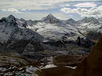
Roundish big mountain, between the Pontonnet Pass and the Fenetre (Window) Champorcher, has two major peaks of which the first (north-northwest) falls on the first of the two hills and then continue in the direction of the Eiffel Pontonnet forming the southern buttress of Tersiva (3.515m); the second one is aimed at Fenetre before the watershed gets up in the near Bec Costazza (3.092m) and to the farthest Cima of Péradza (3.021m), where the partition ends between the valleys of Champorcher (East) and Cogne. The other two "peaks" in existence to be more than these are the joints: the first face to the west-northwest separates the deep North Slope, which extends to the west of the Col Pontonnet from a vertical wall West, not yet risen, pointing Alpe del Ponton and fiancheggita right by a steep slope south-southwest rocky-grassy path downhill and probably only once in 1897. the other Ante Summit down from the South (3.042m) on the opposite side of the Miserin, for separating the Eastern Slope crushed by a wall Southeast, not yet explored, looming over the cabin before Fenetre. All of these routes have been abandoned or discarded over time in advance, since there is little attraction for climbing and dangers far exceed expectations in this regard. Sure the most followed is that of the first climber of 1849, but remaining more to the right of the northeast slope below him, that is almost always on the edge of the ridge north-northwest, as did John Bobba, alone, in 1877. But this Summit antecedemente may have already been visited by the Keeper of Cogne and Champorcher of King Vittorio Emanuele I, as evidenced by the positions of the Hill Pontonnet hunting. Beautiful, easy and scenic hike, suitable for the practice of Ski-Mountaineering; unfortunately, the approach is extended to Dondena from Lillaz limit the number of visits. Climbing fun is offered by the rise through the Corner West-northwest, starting from the same saddle about 2.840/5 meters immediately to the Southeast of Lake Pontonnet (2.035m). Remarkable point of observation on the highest peaks of Aosta Valley and until the Ligurian Alps, Monviso and Argentera, but and especially on the whole, nearby Gran Paradiso, which you can admire the Eastern sector, here turned to the Southwest, from Tower Lavina, Arolla, Apostles and Roccia Viva/Gay Groups to Summit (4.061m) and from this on Northern watersheed to the La Grivola (3.969m).

Grossa montagna tondeggiante, posta tra il Colle di Pontonnet e la Finestra di Champorcher, si presenta con due creste più importanti, la prima delle quali (Nord-nordovest) scende al primo dei due colli per poi proseguire in direzione della Tour Pontonnet formando il contrafforte Meridionale della Tersiva (3.515 m); la seconda invece s'indirizza alla Fenetre, prima che lo spartiacque si rialzi nel vicino Bec Costazza (3.092 m) ed alla più lontana Cima di Peradzà (3.021 m), ove termina il divisorio tra le Valli di Champorcher (Est) e Cogne. Le altre due "creste" in esistenza più che esser tali son degli spigoli: il primo rivolto ad Ovest-nordovest separa il largo Versante Settentrionale, che si estende ad Ovest del Col Pontonnet, da una Parete Ovest verticale, non ancora salita, rivolta verso l'Alpe del Ponton e fiancheggita a destra da un ripido Versante Sud-sudovest roccioso-erboso e probabilmente percorso in discesa un'unica volta nel 1897. L'altro discende dall'Antecima Meridionale (3.042 m) sull'opposto versante del Miserin, atto a separare il frantumato Versante Orientale da una Parete Sudest, non ancora esplorata, incombente sulla baracca prima della Fenetre. Tutti questi itinerari sono stati abbandonati nel tempo o scartati aprioristicamente, poiché non presentano grandi attrattive per l'arrampicata e le pericolosità superano di gran lunga le attese in questo senso. Sicuramente la via più seguita risulta quella del primo salitore del 1849, ma restando più a destra del pendio Nordest da lui seguito, cioé quasi sempre sul filo del crestone Nord-nordovest, come fece Giovanni Bobba, da solo, nel 1877. Ma questa Sommità potrebbe essere già stata antecedemente visitata da parte dei Guardiacaccia di Cogne e di Champorcher di Re Vittorio Emanuele I°, come testimoniano le postazioni di caccia al Colle Pontonnet. Bella, facile e panoramica escursione, adatta anche alla pratica dello Sci-Alpinismo; purtroppo i lunghi avvicinamenti, sia da Dondena che da Lillaz, limitano il numero delle visite. Un'arrampicata divertente viene offerta dalla salita tramite lo Spigolo Ovest-nordovest, iniziando la medesima da una selletta subito a Sudest del Lago Pontonnet. Formidabile punto di osservazione sulle più alte vette valdostane e fino alle Alpi Liguri, Monviso e Argentera, ma soprattutto sull'intero e vicino Massiccio del Gran Paradiso (4.061 m).
First Ascents
- First on the Summit NE Wall: Abbot Pierre Chanoux, (1849), in ascent from Cogne-Lillaz.
- In winter: Unknown.
- N-NW Arête (from Pontonnet Lakes): Giovanni Bobba, solo, (1877).
- W-NW Edge (integral, from Ponton Alp): Osvaldo Cardellina and Emilio Bertona, (Sep 02th, 1999). First Repetition: Osvaldo Cardellina, Emilio Bertona, Gianfranco Vicentini and Nicola Colajanni (Aug 02th, 2002), in ascent from Pontonnet Lakes. Second Repetition: Osvaldo Cardellina and Emilio Bertona, (Sep 05th, 2005), Pontonnet.
- SE Arête: Engineer Paganini and Elyseé Jeantet, (1861), in ascent from Lillaz.
- S-SW Slope: Giovanni Bobba and Pietro Perret, (Sep 12th, 1897).
Getting There
BY CAR:- From Torino, Milano, etc: Motorway A5. Exit at Aosta Ovest. Drive to the near Aymavilles. Follow the directions for Valle di Cogne.
- From Switzerland: through the Grand Saint Bernard Tunnel or the namesake Pass. Drive to Aosta, then follow the direction for Courmayeur on SS.26. Just after Sarre, turn to the left, in the direction of Valle di Cogne.
- From France: through Mont Blanc Tunnel or Petit St. Bernard Pass. It isn't necessary to take Motorway A5: you can drive on SS.26, in the direction of Aosta.Before arriving at the Village of Sarre, turn right following the sign for Valle di Cogne. After Aymavilles, the SR.47 crosses the Villages of Vieyes, Epinel and Cretaz and after about 25 Km arrives at Cogne (1.534m). From Cogne you can get the Village of Lillaz (1.617m).
- Aeroporto "Corrado Gex" Saint Christophe (Aosta).

Approaches from Lillaz & Dondena
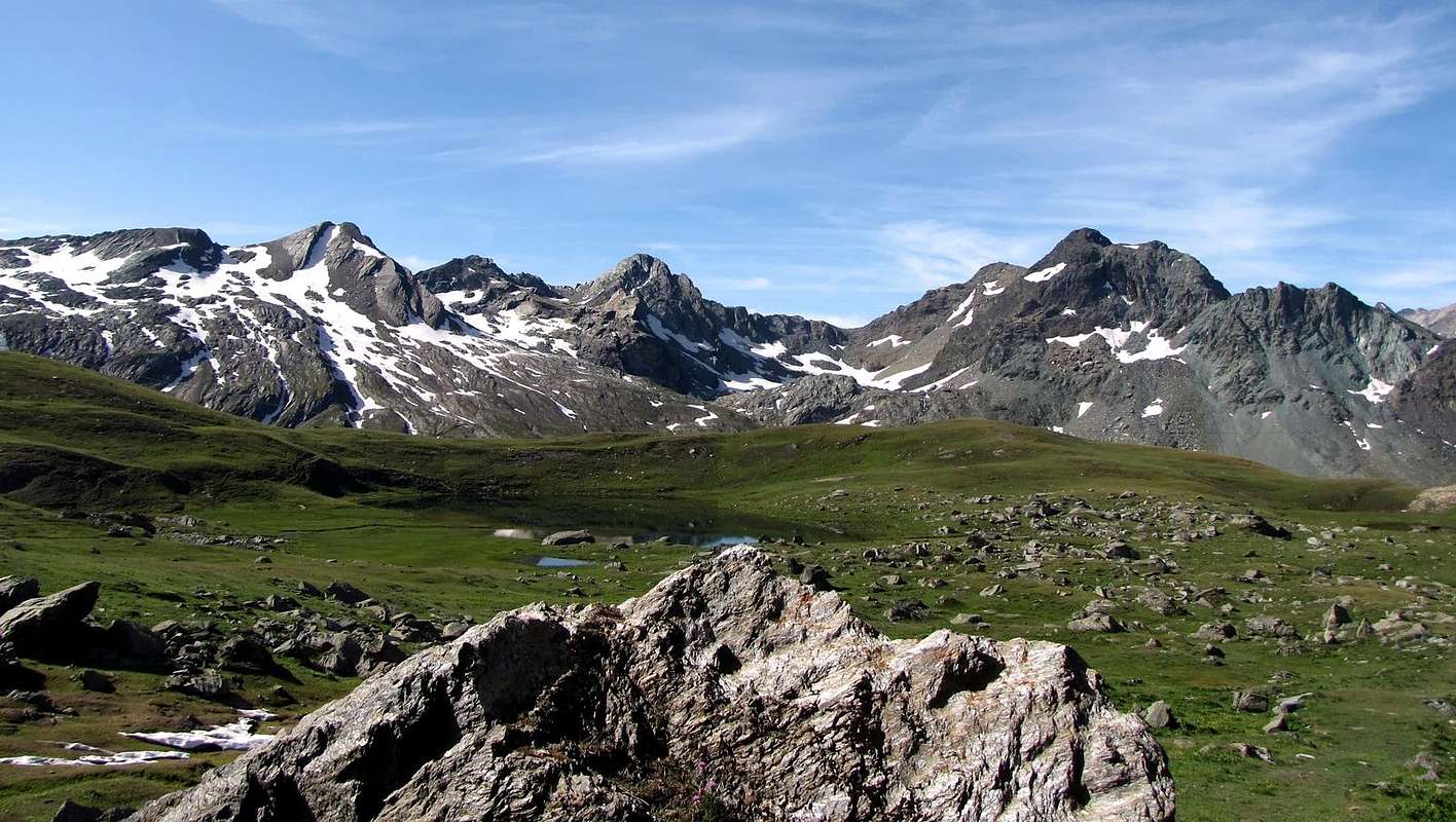
A) - From Lillaz towards Urtier Walloon and by Sogno di Berdzé Refuge: Starting from Cogne (1.534m) you must arrive (bus or car) to the car parking of Lillaz (1.617m). Follow the path n° 13/TVC/Alta Via n° 2 below upaved road, until reach Baite di Gollies Low and Upper (1.831m, 1.869m; here you can also get along the same route with slightly longer, less direct but certainly more scenic). Move on until tiny Church of Crêt (2.020m; wooden fountain), clearly visible from lowlands. Once gone beyond Tsavanis (2.296m; fountain), preceded by a magnificent waterfall upon the Torrent Urtier and above the private farms dirt road and Manda (2.370m) Pastures, the refuge is reached, immediately after a fresh spring water from a rock in a great boulder (3h'30/3h'45, from Lillaz parking). From Sogno di Berdzè (2.526m) hut, follow Southeast direction down the walloon, proceeding through a series of parallel rocky slabs alternate with ledges at the bottom and on snowfields not too steep in the upper one, heading for a most visible saddle, progressively climbing. Keep going left (North) direction, and once gone beyond some steep slopes, move toward the true base of the mountain (*** Remark: the crest, especially in the descent phase, can be walked just below with significant savings in time), through a ridge. Continue to climb on rag rocks to arrive at a big stone, then marching on wreck slopes to reach the final rocky ridge and the Summit (2h'00/2h'15, from the Hut "Sogno di Berdzé").A) - Da Lillaz attraverso il Vallone dell'Urtier appoggiandosi al Rifugio Sogno di Berdzé: Dall'abitato di Cogne (1.534 m) in bus o in auto raggiungere la ridente frazione di Lillaz (1.617 m), dove si parcheggia l'auto nel grande piazzale sito quasi al centro del villaggio. Percorrere il sentiero n° 13/TVC/Alta Via n° 2 al disotto della strada poderale e lungo la sponda Settentrionale del Torrente Urtier fino alle Baite di Gollies Dessous e Dessus (1.831 m, 1.869m; qui si può arrivare anche percorrendo la medesima con itinerario leggermente più lungo, meno diretto, ma sicuramente maggiormente panoramico); continuare fino alla Chiesetta del Crêt (2.020 m; bella fontana scavata nel legno), ben visibile dal basso, e oltrepassati gli Alpeggi di Tsavanis (2.296 m; fontana), preceduto da una bella cascata sopra il Torrent Urtier al di sopra della poderale, ed il successivo di Manda (2.370 m) si raggiunge il Rifugio "Sogno di Berdzè" (Sogno di Pastore) presso l'Alpe di Peradzà, subito dopo un tornante seguito da un lungo rettilineo in leggera ascesa giusto appresso una fresca sorgente sgorgante da un gran masso nella roccia (3h'30/3h'45 dal parcheggio di Lillaz). Dal Rifugio Sogno di Berdzé (2.526 m), dopo aver subito attraversato il Torrent de Peradzà, seguire verso Sudest il fondo del vallone, procedendo tramite una serie parallela di banconate rocciose alternate a cenge nella parte inferiore e su nevai non troppo ripidi che gradualmente piegano sulla sinistra (Sudest) in quella superiore, in direzione di una sella (2.946 m), sempre più in vista progressivamente salendo. Continuare a sinistra (Nord) e superati alcuni dossi risalire su cresta sino alla vera base della montagna (*** Nota: la cresta, soprattutto in fase di discesa, può essere percorsa appena al di sotto con significativo risparmio di tempo; infatti le Quote varie succedentesi sono più lunghe da percorrersi che non difficili), continuare su roccia friabile fino ad un grosso masso, poi per un pendio di sfasciumi e un tratto di cresta a blocchi raggiungere la Vetta (2h'00/2h'15) dal rifugio.
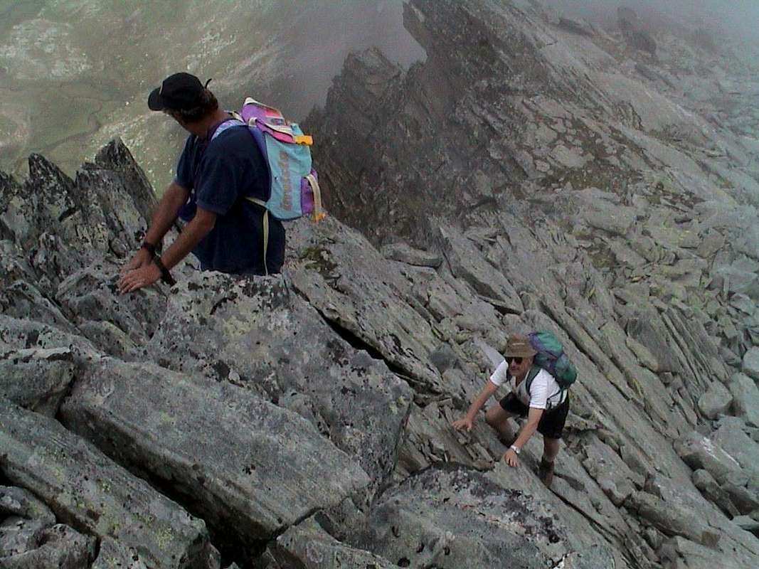
B) - From Champorcher also from Dondena Refuge to Miserin Shelter neighbor the Lake: Champorcher-Château (1.427m) go to the Village La Cort where, shortly afterwards, began the dirt "Royal Route" numbered 9/High Way n° 2; crossed to the Alps Vardette, Brenvei, Champlong Grand, Grand Pianas and Leituerie you arrive at the small parking lot just above the Village of Dondena (2.110m, panels and reports signs in yellow). After a short descent we cross the Torrent Ayasse on a small stonebridge continuing through the private farms dirt road (prohibition of passage for cars) that reaches the Dondena Refuge (2.200m). From this continue Westward with it, concomitant with the path n° 7B/Alta Via n° 2, concluding with a short ascent to the South; or starting immediately behind the same, better, with the path n° 7 to reach the Miserin Shelter (2.582m; Sanctuary; 1h'00/1h'15) at the lake of the same name. This trip is already satisfactory for itself along a route that each year is crossed by a famous procession which takes place August 5th, dedicated to Madonna delle Nevi (Our Lady of the Snows) and full of a centuries-old tradition and with the participation of the inhabitants of the nearby valleys of Piedmont. It should surely the second path, the more "rapid" and less "busy" from the crowd of Walkers. From the Rifugio Miserin move towards West to a grassy-rocky promontory just to the right of the "Truc of the Lake" (2.703m); absolutely not go up directly, but using a small path unnumbered, to dub the same to the North, reaching the summit of the same (2.841m). Here the East-northeast Crest appears simple and consists of a large, grassy rounded off; the same ends, after a large rounded saddle at a edge of rocks bluish, very thin and dangerous, especially when wet to moist soil or worse. Cross it with almost flat path but exposed on both sides. After a long flight of soil and debris (around 70 meters, boring and tiring) leads to a small fork against a small and gray pillar. Do the same on the left and climb through a ramp diagonally from right to left highlighted by a block detached to about half (II°+/III°-); or descend for about 10 meters and climb through a gray slab and "lying" that leads to a rocky groove (II°-). Through this you reach the point of crossing with the previous ramp, just above. A series of fairly easy rocks, arranged in terraces but covered with soil and grass also leads after eighty feet the cairn on the Summit (EE/A/PD-; 1h'30/2h'00 from Shelter near Lake Miserin ; 2h'45/3h'15 from Refuge Dondena).
B) - Da Champorcher o dal Rifugio di Dondena appoggiandosi al Rifugio del Lago Miserin: Da Champorcher-Château (1.427 m) salire fino alla Frazione La Cort dove, poco oltre, inizia la "Strada Reale" in terra battuta numerata 9/Alta Via n° 2; superate le Alpi di Vardette, Brenvei, Grand Champlong, Grand Pianas e Leituerie si arriva al piccolo parcheggio appena sopra il Villaggio di Dondena (2.110 m; pannelli e segnalazioni segnaletiche in giallo). Dopo una corta discesa si guada il Torrent Ayasse su di un piccolo ponte proseguendo tramite la strada poderale (divieto di passaggio per le auto) che raggiunge il Rifugio Dondena (2.200 m). Da questo continuare verso Ovest con la medesima, concomitante con il sentiero 7B/Alta Via n° 2, per concludere con una piccola salita a Mezzogiorno; oppure partendo subito dietro lo stesso, e meglio, con il sentiero n° 7 raggiungendo il Rifugio del Miserin (2.582 m; Santuario; 1h'00/1h'15) presso l'omonimo Lago. Questa risulta già gita soddisfacente per se stessa lungo un itinerario che ogni anno viene percorso da una famosa Processione effettuata il 5 di Agosto e dedicata alla Madonna della Neve; la stessa é ricca d'una tradizione centenaria ed alla quale partecipano pur gli abitanti delle vicine Valli del Piemonte. Conviene di certo il secondo sentiero, più "rapido" e meno "affollato" dalla massa. Dal Rifugio Miserin indirizzarsi verso Ovest verso un promontorio roccioso-erboso subito a destra del "Truc del Lago" (2.703 m); non salire assolutamente in modo diretto ma, sfruttando un sentierino non numerato, doppiare lo stesso a Settentrione raggiungendone la Sommità (2.841 m). Qui la Cresta Est-nordest si presenta facile e formata da un grosso ed erboso tondeggiante dosso; lo stesso termina, dopo una larga sella arrotondata, presso una cresta di rocce bluastre, molto sottile e pericolosa in caso soprattutto di terreno umido od ancor peggio bagnato. Attraversarla con percorso quasi pianeggiante ma esposto su di entrambi i lati. Al termine una lunga rampa di terriccio e detriti (70 metri circa, noiosa e faticosa) conduce ad una forcelletta contro un pilastrino grigiastro. Evitare il medesimo sulla sinistra e salire tramite una rampa diagonale da destra a sinistra evidenziata da un blocco staccato a circa la metà (II°+/III°-); oppure scendere per circa 10 metri e salire tramite una placca grigia e "adagiata" che conduce ad un canalino roccioso (II°-). Tramite questo si raggiunge il punto della precedente traversata, appena al di sopra. Una serie di abbastanza facili rocce, disposte a gradoni ma ricoperte da terriccio ed anche d'erba, conduce dopo una ottantina di metri all'ometto di pietra della Cima (EE/A/PD-; 1h'30/2h'00 dal Rifugio al Lago Miserin; 2h'45/3h'15 dal Rifugio di Dondena).
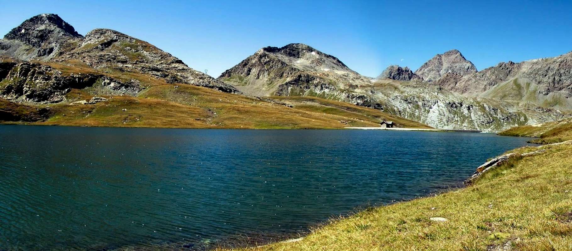
 |
 |
 |
 |
 |
Route
From "Sogno di Berdzè (2.526m), to continue on the path n° 13/TVC/Alta Via n° 2 for the Fenetre de Champorcher (2.826m) until the alternative (2.682m); through the path n° 10F, with diagonal route to left, to ascend in direction Northwest until the small ponds (2.742m and 2.873m), to continue on the dirt road poderale until the "Baita Orlando" (2.641m). From this last, through the path n° 10E to go back after in North direction and then East to the two Lakes Pontonnet (2.808m and 2.816m) and to the Pontonnet Hill. To continue on the easy Ridge North-northwest that leads, after an Ante Top connecting with West-northwest Edge, to the peak exceeding the rise to 2.922 meters (3h'30 from refuge).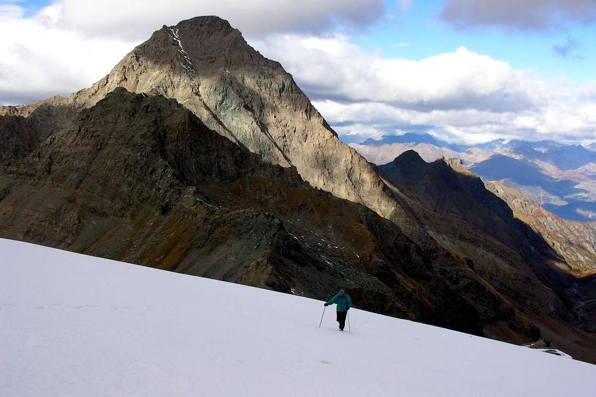
Dal "Sogno di Berdzè" continuare sul sentiero n° 13/TVC/Alta Via n° 2 per la Finestra di Champorcher (2.826 m) sino al bivio (2.682 m); tramite il sentiero n° 10F, in diagonale verso sinistra, salire in direzione Nordovest fino ai laghetti (2.742 m e 2.873 m), per poi continuare sulla strada poderale fino alla "Baita Orlando" (2.641 m). Da quest'ultima, tramite il sentiero n° 10E, risalire dapprima in direzione Nord e poi Est ai due Lacs Pontonnet (2.808 m e 2.816 m) ed al soprastante Colle Pontonnet. Progredire lungo la facile cresta Nord-nordovest che, dopo una Antecima alla confluenza con lo Spigolo Ovest-nordovest, conduce alla Vetta oltrepassando più in basso il dosso a 2.922 m (3h'30 dal rifugio).
 |
 |
 |
 |
 |
Various Other Routes
In addition to the normal route from the Pass Crest Pontonnet through the North-North-West, or leaning on the North side to northeast just to the left going up, there are other ways that we list here just being basically the same only the variants that rise up along the extended North Slope to reach the edge West-northwest. In any case, the slope is always on the road to the Col Pontonnet coming out and taking the path to the right, ie in the direction of South or Southeast slope off North.The listed from east to west giving a short hatching of the same:
1) - Via "shell-shaped" it's a small walloon immediately West of the Normal Route; being covered with snow throughout the year is useful for a rapid descent or ascent to a teaching where novices can get in touch with the use of crampons passing a slope that gradually increases, but without excessive slopes (from 30° to around 33°).
2) - Way "of colorless or Jalin quartzs" just to the right of the previous route, it is a fun location "research" which aims to raise the whole side without leaving a long streak. 3)- Way "of the North-northwest Slope" lies between the previous and is bounded on the right by the West-northwest Corner; runs on a wide slope "open" and it is, though rarely covered in Ski-Mountaineering. At its base, on the right, or West, there are rocky plates useful for a fun workout, especially for young beginners.
4) - Via on "West-Northwest Edge": the right edge of this side rises an edge that exceeded two rocky headlands, the Ante Top Northwest reaches the junction with the Standard Route. The same divide the North Slope to a vertical wall facing West. You can climb either starting from the Alp Ponton (2.631m), after the "Baita Orlando" (2.641m), by means of a steep gorge that leads to the base (as for the first ascent; about 2.840/5 meters), or, much better, achieving this with larger circle without descending to Ponton and starting with the path for the two Lakes Pontonnet. Climbing does not have a fixed course and varies somewhat depending on the past sought and takes place on rock route but good enough. There are lots of opportunities for circumvention to the left (North) just below the edge, but the location on the corner of the ridge is more secure and enjoyable. All other ways, as we have already said, are not advisable since the rock, in addition to being somewhat broken, is covered by dangerous layers grassy; remains a final comment on the Slope North-northeast, toward the Champorcher Valley, which can be used, again with appropriate caution, the nice trips Ski-Mountaineering, starting from the Dondena Village or its Refuge also from this of the Miserin nearby the homonym Lake. his course (preferably via the nearby Pontonnet Pass) can also be adapted to Snowshoeing.
 |
 |
 |
 |
 |
Oltre alla Via Normale dal Colle Pontonnet tramite la Cresta Nord-nordovest, oppure appoggiando sul Versante Nord-nordest appena più a sinistra salendo, esistono altre vie che qui semplicemente elenchiamo essendo in fondo le medesime solo delle varianti che salgono lungo lo esteso Versante Nord fino a raggiungere lo Spigolo Ovest-nordovest. In ogni caso la salita avviene sempre sulla via che conduce al Colle Pontonnet uscendo dal sentiero e portandosi verso destra, cioé Sud o Sudest in direzione del largo pendio Settentrionale.
Le elenchiamo da Est verso Ovest dando un breve tratteggio delle medesime:
1) - Via "a forma di conchiglia": trattasi d'un ristretto valloncello subito ad Ovest della Normale; essendo innevato per tutto l'anno risulta utile per una rapida discesa oppure per una salita didattica dove i debuttanti possono prendere contatto con l'utilizzo dei ramponi superando un pendio che aumenta gradualmente senza pendenze eccessive (da 30° a 33°).
2) - Via "dei Quarzi Ialini": subito a destra della precedente via, é un divertente percorso di "ricerca" che mira a salire l'intero versante senza mai abbandonare una lunga vena.
3) - Via "del Versante Nord-nordovest": si apre tra la precedente ed é delimitata sulla destra dallo Spigolo Ovest-nordovest; percorre su di un largo pendio "aperto" e viene, anche se raramente, percorsa nello Sci-Alpinismo. Alla sua base, sulla destra od Ovest, esistono delle placche rocciose utili ad un divertente allenamento, soprattutto per giovani principianti.
4) - Via "dello Spigolo Ovest-nordovest": al limite destro di questo versante sale uno spigolo che, superati due promontori rocciosi, raggiunge l'Antecima Nordovest alla congiunzione con la Via Normale. Lo stesso divide il Versante Settentrionale da una parete verticale rivolta ad Ovest. Si può salire sia partendo dall'Alpe Ponton (2.631 m), dopo la "Baita Orlando" (2.641 m), per mezzo di una ripida gola che conduce alla base (come per la prima salita), oppure, molto meglio, raggiungendo questa con giro più largo senza scendere al Ponton e partendo con il sentiero per i due Laghi Pontonnet. L'arrampicata non ha un percorso obbligato e varia alquanto a seconda dei passati ricercati e si svolge su roccia rotta ma abbastanza buona. Esistono molte possibilità di effettuare aggiramenti a sinistra (Nord) subito al di sotto dello spigolo, ma il percorso sul filo di cresta é più sicuro nonché divertente. Tutte le altre vie, come già abbiamo detto, non sono consigliabili poiché la roccia, oltre ad essere alquanto rotta, si presenta ricoperta da pericolosi strati erbosi; rimane un'ultima considerazione sul Versante Nord-nordest, rivolto verso la Valle di Champorcher, che può essere usato, sempre con le adeguate cautele, nelle piacevoli gite Sci-Alpinistiche dal Villaggio di Dondena, dal suo Rifugio o da quello presso il Lago Miserin. Questo percorso (meglio tramite il vicino Colle Pontonnet) può essere adattato anche alle Racchette da neve.
Difficulties
This route can be considered EE/from F to F+.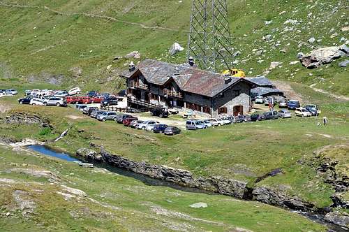
Equipment
Standard mountaineering equipment.Da escursionismo.
Campings
Remember that free camping is forbidden (except for emergency reasons, over 2.500m, from darkness until dawn). |
 |
 |
 |
Mountain Condition
- Meteo: you can find all the needed informations at the official site of the Valle d'Aosta Region:
- Valle d'Aosta Meteo
Webcam
- WEBCAM on Aosta Valley:
- Webcam
Books and Maps
BOOKS:
- "Guida delle Alpi Occidentali" di Giovanni Bobba e Luigi Vaccarone C.A.I. Sezione di Torino Volume II (parte II), 25 Maggio 1896.
- "Guida dei Monti d'Italia–Emilius Rosa dei Banchi Parco del Mont Avic" di Giulio Berutto e Lino Fornelli-Club Alpino Italiano/Touring Club Italiano, Marzo 2005 (in Italian).
- "I Rifugi della Valle d'Aosta" di Stefano Ardito, Ed. Guide iter, Febbraio 2003.
- "Guida della Regione Autonoma Valle d'Aosta" di Mario Aldrovandi; Ed. S.P.E. di Carlo Fanton, Torino 1964.
- "Diari Alpinistici" di Osvaldo Cardellina e Indice Generale accompagnato da Schedario Relazioni Ascensioni 1964-2019 (inediti).
 |
 |
 |
 |
 |
MAPS:
- Enrico Editore Ivrea-Aosta "Gruppo del Gran Paradiso" 1:50.000.
- L'Escursionista "Valle di Cogne Carta dei Sentieri" 1:25.000.
- Kompass "Gran Paradiso Valle d'Aosta Sentieri e Rifugi", Carta turistica 1:50.000.
Important Information
- REGIONE AUTONOMA VALLE D'AOSTA the official site.
- FONDAZIONE MONTAGNA SICURA Villa Cameron, località Villard de la Palud n° 1 Courmayeur (AO) Tel: 39 0165 897602 - Fax: 39 0165 897647.
- SOCIETA' GUIDE ALPINE DI COGNE Tel. 347/9473526 – 328/1373728.
- A.I.NE.VA. (Associazione Interregionale Neve e Valanghe).
- A.IA.T. Cogne Gran Paradis via Bourgeois n° 34 Tel. 0165-74040. E-mail: aiat@cogne.org
- Ezio Sport articoli sportivi - via Bourgeois n° 64 Tel. 0165-74204.
Useful Numbers
- Soccorso Alpino Cogne (SAR) Tel. 3482685406.
- Protezione Civile Valdostana località Aeroporto n° 7/A Saint Christophe (Ao) Tel. 0165-238222.
- Bollettino Meteo (weather info) Tel. 0165-44113.
- Unità Operativa di Soccorso Sanitario Tel. 118.