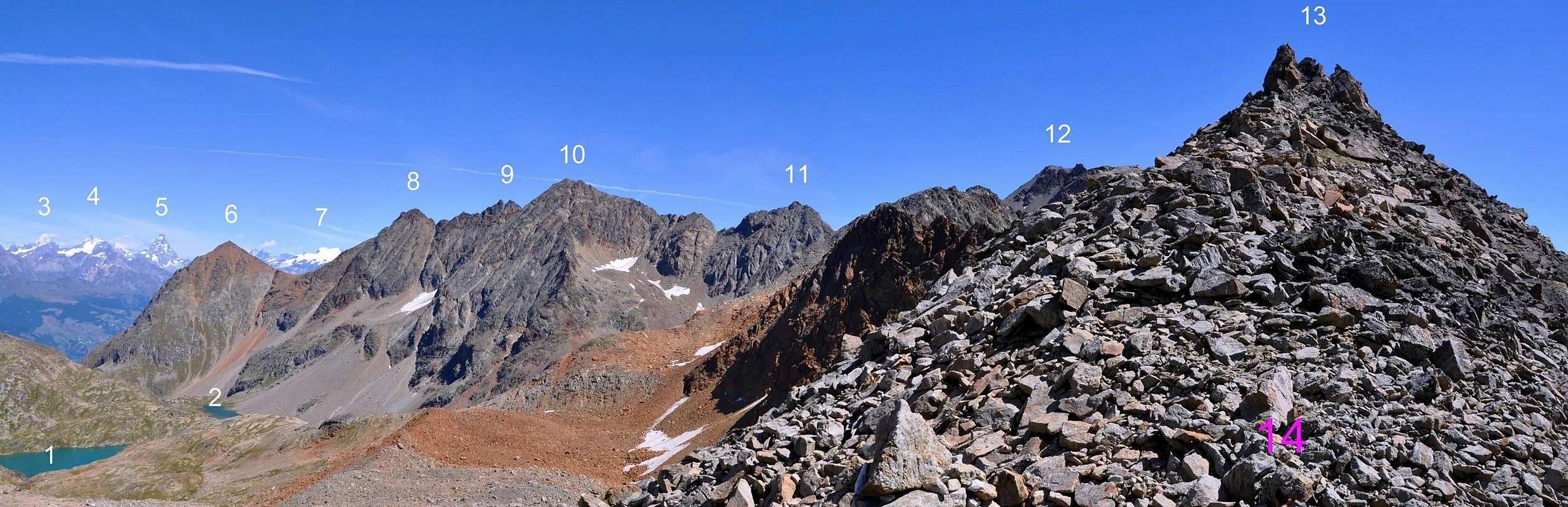
Mountain in the shape of round "great bread", sited on watershed crest between Laures Valley or of Brissogne (in North) and Grauson-Lussert (in South and over Cogne Tourist Resort and Gimillan Village). A long ridge tied in East with Lussert/Leppe Points, whereas a more brief and more steep difficult edge in West, after the Laures Pass (3.036m), join together Laures/Emilius Reds Points. In old times rarely popular and by sole hunters, almost exclusively; on the last two decades busy by hikers and mountaineers looking unusual and uncommon aims. From its Summit enjoy doing wonderful views in Northern towards Laures Lakes and in Southern on those of Lussert; make a fine display the Great Paradise, with his entire Mountain Chain in South. Good excursion into a natural and uncontaminated habitat, in high head solitary again. Connection possibility for splendid crossings amongst Lussert/Laures/Arbolle and even Saint Marcel Valleys, with, sometimes, sudden encounters of ibex also chamois packs; non seldom on the wing of Royal Eagle.
Montagna a forma di tondo panettone, situata sulla cresta divisoria il Vallone delle Laures o di Brissogne (N) da quello del Grauson-Lussert (S, sopra Cogne/Gimillan). Una lunga cresta la lega verso E alle Punte di Lussert/Leppe, mentre una più breve, difficile e ripida la unisce, dopo il Col des Laures (3.036 m), alle Punte di Laures/Punta Rossa dell'Emilius. Una volta frequentata raramente e quasi esclusivamente da parte di cacciatori, mentre negli ultimi 15/20 anni ha evidenziato una certa frequentazione anche da parte di escursionisti ed alpinisti alla ricerca di mete inusuali. Dalla sua cima si godono meravigliose viste sui Laghi delle Laures verso Settentrione e su quelli di Lussert a Meridione, dove si mette in bella mostra l'intera Catena del Gran Paradiso. Bella gita in un ambiente ancora non contaminato e, nella parte alta della testata, ancora solitario. Varie le possibilità di combinazione per splendide traversate tra i Valloni del Lussert/Les Laures/Abolle ed anche Saint Marcel con inaspettati, a volte, incontri con interi branchi di stambecchi o camosci; frequente anche il volo dell'aquila.
First Ascents
First on the summit: Unknown.
In winter: Unknown.
Getting There
BY CAR:
From Torino, Milano, etc: Motorway A5. Exit in Aosta Ovest. Drive to the near Aymavilles. Follow in the direction of Valle di Cogne. Exit Aosta est For Grand Brissogne and Saint Marcel.
From Switzerland: through the Grand St. Bernard Tunnel or the homonym Pass). Drive to Aosta, then follow Courmayeur direction on SS.26. Just after Sarre, turn to the left, in the direction of Valle di Cogne. For Grand Brissogne and Saint Marcel, turn to the right.
From France: through Mont Blanc Tunnel or Petit St. Bernard Pass). It isn't necessary to enter in Motorway A5, you can drive through SS.26 Aosta direction. Before arriving at the Village of Sarre, follow the sign and turn right towards Valle di Cogne.After Aymavilles, the SR.47 crosses the Villages of Vieyes, Epinel and Cretaz and after about 25 Km. arrives at Cogne (1.534m).Follow the road signs for Gimillan and Lillaz; arrived at a round-about, recently built in proximity of the St. Anthony Chapel, go left along the scenic route leading to the Village of Gimillan(1.787m) 3 Km. after Cogne. Usually no parking problem. Exit Aosta est For Grand Brissogne and Saint Marcel.
BY PLANE:
Aeroporto "Corrado Gex" Saint Christophe (Aosta).
Approachs
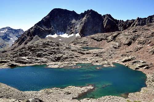
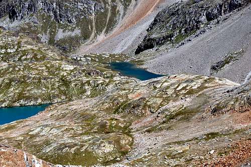
1) - From Gimillan: (1.787m) go right starting from the car park 1.800m~ of Gimillan: after few meters the indications for Lussert Lakes, St. Marcel Pass, etc. are found. The pathway is indicated by the yellow circle 9A and by yellow strips marked on stones along the route. The path begins going immediately uphill, then the slope decreases as we go beyond Révènti Alp (1.906m; ruines) and a little Chapel dedicated to the Virgin (1.836m). Soon the path resumes to go up and splits in two, before it begins to penetrate into the Grauson Valley: it's possible to continue following the right one that goes down as far as the Ecloseur Bridge (1.904m; shop-sign Tchezeu Alp; 1.918m), but in such a case we must go up again; it's better to follow the left one that, in practice without losing height, arrives at the bridge under the Pila Alp (2.025m), cross it and, following the stepped pathway, overcome the rocky bastion beside a fine waterfall (at the left). At this point the path turns right markedly, entering, high on the torrent, into a small valley; by an alternation of steep and slight slopes, it reaches a panoramic cross, on the edge of a pleasant plateau (superb view of the far La Grivola!). The path goes through the meadows, slightly descending: after the Old Grauson’s Pastures (2.271m), crosses the Doreire Torrent on the Pikaciù Bridge and by a steep trail beside the stream, reach the wide upper part of the Grauson Valley. At the junction before Pralognan Pasture (about 2.400m), instead of going straight ahead along the pathway n°4 leading to the head of Grauson Valley, go left (North) till to Grauson Nuove Pasture (2.540m), where once there was the burned Tentori Bivouac, on Summer 2000. Along grassy slopes and great blocks by path toward the Lussert Lower Lake (2.721m), then after passing a steep prominence, to the Middle Lake (2.800m) and to the Higher Lake (2.926m).
1) - Da Gimillan (1.787 m): partire dal parcheggio (1.800 m~) trovando dopo pochi metri I "panneaux" con le indicazioni per I Laghi Lussert, il Colle di Saint Marcel o Corona, ecc. Scegliendo quello giallo/nero cerchiato con l'indicazione 9°. Il sentiero inizia salendo immediatamente in ripida salita per poi diminuire in pendenza andando verso l'Alpe Révèntì (1.906 m; rovine) ed incontrando subito dopo una piccola Cappella dedicata alla Vergine (1.836 m). Subito dopo il sentiero riprende a salire con falsopiano e dividendosi in due presso un grosso cartello indicatore con piccola tettoia; tenendosi sulla destra (E) penetrare nel Vallone del Grauson e, tramite una breve discesa, raggiungere il Ponte dell'Ecloseur (1.904 m; cartello indicante l'Alpe Tchezeu; 1.918 m). Attraversarlo sul Torrente Lussert e, lasciate le Alpi Ecloseur appena a destra, con un lungo diagonale a sinistra ed in mezzo ai prati raggiungere la successiva di Pila (2.025 m), con alla sua sinistra una bella cascata. Superare la soprastante bastionata rocciosa doppiandola a sinistra per poi ritornare a destra passando alti sul torrente in una valletta; con pendenze alternate e lievi raggiungere una croce su un promontorio panoramico (superbe vedute sulla lontana La Grivola!). Il sentiero attraversa la prateria in leggera discesa: dopo Grauson Vecchie (2.271 m) attraversa sul Ponte di Pikaciù il Torrente Doreire e con un ripido percorso accanto al torrente raggiunge la parte larga e superiore del Vallone del Grauson. Verso la congiunzione prima dell'Alpe di Pralognan (2.400 m~), invece di salire direttamente avanti lungo il sentiero n°4 che abbandona la testata del Vallone di Grauson, girare a sinistra (N) sino all'Alpe di Grauson Nuove (2.540 m), ove esisteva il Bivacco Tentori andato a fuoco nell'estate del 2000.
2) - Starting: from Grand Brissogne-Primaz (894m), go along the road till the Gremonenche Alp (1.000m). From here along the dirt road up to l'Arp (1.310m; end of same) then, along a path that, bordering the stream (Des Laures Torrent), leads to La Vieille (1.623m) and to Le Tramail or Tramouail (1.951m; = intermediate pasture for cows, good shelter when weather is bad, always open). Crossing some small wooden bridges up to the altitude of 2.200m, (starting from this point a steep but faster path goes, at right (W), toward the slopes of Becca di Seneva). Better go on toward E forwarding the Becca di Salè (Black Fountains) and climb the last 400 meters on wide slopes till the top of the rocky terraces (2.600m) (here a small chapel dedicated to two brothers "Dino" and Jean Charrey and Cino Norat dead in 1929 on the East Wall of Monte Emilius). A short descent leads to the Refuge Ernesto Mènabreaz, partisan by Nazi-Fascist execution firing squad (2.542m, private), the refuge has an open free part (with covers, wood-burning stove and provisioning) usable as winter room (8 places), on the eastern bank of Laures Lower Lake. From here toward South getting, after a short step in East of with same name alp, the of Laures Long Lake (2.630m); walk all along the western bank on the path that fast becomes a track turning toward the lower part of the morenal tableland in quota 2.763m, near Montet Torrent. Go up toward fork 2.933m, nearby a mini-tiny lake; leaving in right (West) the path to Arbolle Pass, continue by winding route amongst great blocks, rubbles and debris reaching easily the Laures Pass (3.036m; 1h'30).
2) - Da Gran Brissogne-Primaz (894 m) salire con la strada poderale verso l'Alpe di Gremonenche (1.000 m) trovando il cartello di divieto presso il Villaggio di Luin. Da qui lungo la strada poderale raggiungere l'Alpe di L'Arp (1.310 m; termine della stessa) e poi, con il sentiero fiancheggiante il Torrent des Laures, le successive di La Vieille (1.623 m) e di Tramail o Tramouail (= pascolo intermedio per le mucche; ottimo ricovero in caso di cattivo tempo; sempre aperto; 1.951 m). Attraversando alcuni piccoli ponti in legno, raggiungere la quota di 2.200 m (partendo da questo punto si snoda verso destra (W) e contro le pareti della Becca di Seneva un sentiero più ripido ma anche più veloce nelo prendere dislivello). Migliore è la salita però portandosi ad E contro la Becca di Seneva (Via delle Fontane Nere) risalendo gli ultimi 400 metri su larghi pendii adducenti a larghi terrazzamenti rocciosi (2.600 m; piccola Cappella dedicata ai due fratelli Alessandro "Dino" e Jean Charrey ed a Cino Norat, caduti nel 1929 sulla Est dell'Emilius). Una piccola discesa porta al Rifugio Ernesto Ménabreaz, intitolato al partigiano fucilato dai nazi/fascisti (2.542 m; privato ma con un locale sempre aperto per gli alpinisti e attrezzato con 8 posti letto, coperte, stufa a legna e vettovagliamento), posizionato sulla sponda orientale del Lac Dessous des Laures. Da questi progredendo vero S con un sentierino e, passando a sinistra dell'omonima alpe, raggiungere il Lago Lungo (2.630 m) e, continuando sulla sua sponda occidentale, tramite sentiero raggiungere verso S-SW la spianata morenica a quota 2.763 m, vicino al Torrent Montet. Quando presto diventa una traccia una traccia, risalire al bivio 2.933 m, presso un minuscolo laghetto; lasciando a destra (W) la via per il Colle d'Arbolle, continuare con percorso sinuoso tra grandi blocchi, frantumi e detriti raggiungendo facilmente il Col des Laures (3.036 m; 1h'30).
Route
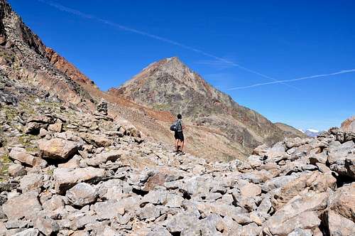
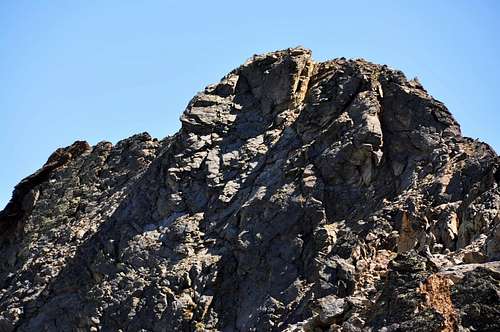
From Grauson Niew Pasture (2.540m), along grassy slopes and great blocks by path toward the Lussert Lower Lake (2.721m), then after passing a steep prominence, to the Middle Lake (2.800m) and to the Higher Lake (2.906m). At once before of effluent, the path turn in North direction passing a great boulders area and, after by a brief diagonal, reach the Laures Pass (3.036m; 4h'00/4h'30). From pass turn in East climbing the of Laures’s Mount (3.121m) W Crest, before by rotten rocks and easy blocks moving to the right below a typical rocky "canon", about thirty metres high. Turn in South by a short and very narrow earthy ledge in diagonal ascent left/right (I°+; 25 meters; easy but delicate with exposition in South; possibility even in North by broken dark rocks); go down on small saddle 3.081m and continue on ridge, before by solid rock formed by ruddy plates, followed from a second by blackish (II°/II°+ in edge; amusing). Also go up slightly under crest by earth-like/rocky ledges always to Summit (I°; 90/100m; 0h'30/0h'40 from pass; 5h'00/5h'30 from Gimillan).
Dall'alpeggio di Grauson Nuove (2.540 m), attraverso pendii erbosi e sentiero aggirante grossi blocchi, raggiungere il Lago di Lussert Inferiore (2.721 m), poi, risalendo un ripido promontorio, quello di Mezzo (2.800 m) ed infine il Superiore (2.906 m). Appena prima dell'emissario, il sentiero gira a N e, superando una zona di grandi "clapeys" prima, e, con un'esile traccia poi, con un piccolo diagonale finale raggiunge il Col des Laures (3.036 m; 2h'15; in totale 4h'00/4h'30). Dal colle girare a E risalendo la Cresta W del Mont des Laures (3.121 m), dapprima su rocce rotte e facili blocchi portandosi sotto ad un caratteristico "cannone", alto un trentina di metri. Aggirarlo a S per un'esile cengia terrosa in salita diagonale da sinistra a destra (I°+; 25 m; facile ma delicato con esposizione a S; possibilità di passaggio a N su rocce rotte e scure); scendere alla forcella 3.081 m e proseguire in cresta, dapprima su roccia sana a placche rossastre, seguite da un secondo rilievo di rocce nerastre (II°/II°+ sul filo; divertente). Oppure salire leggermente sottocresta per cenge terroso-rocciose fino in vetta (I°; 90/100 m; 0h'30/0h'40 dal colle; 5h'00/5h'30 da Gimillan).
Difficulty
The routes can be rated as EE/F+.
L'itinerario è classificato EE/F+.
Gear
Normal hiking equipment.
Da escursionismo.
Campings
Remember that free camping is forbidden (except for emergency reasons, over 2.500m, from darkness until dawn).
Mountain Condition
Meteo: you can find all the needed informations at the official site of the Valle d'Aosta Region:
Parents refers to a larger category under which an object falls. For example, theAconcagua mountain page has the 'Aconcagua Group' and the 'Seven Summits' asparents and is a parent itself to many routes, photos, and Trip Reports.

 6335 Hits
 88.19% Score
 26 Votes