
|
|
Mountain/Rock |
|---|---|
|
|
38.71970°N / 107.3854°W |
|
|
Gunnison |
|
|
Hiking |
|
|
12052 ft / 3673 m |
|
|
Mount Guero Overview
 The interior of the West Elks form the summit of Mt. Gunnison.
 Mount Guero resides in the West Elk wilderness east of Crawford Colorado in an area that is known to see mostly hunters and few hikers or climbers. Despite it's modest elevation, Mount Guero is an aesthetically pleasing peak and represents a good days work for the hiker. Mount Guero is the 44th most prominent peak in Colorado with 2432 feet of prominence. At 12,052 feet it ranks number 1280 among peaks in Colorado.
There is no short route to the summit, however there are several ways in which to access the mountain. The mountain can be accessed from the Sink Creek trail, Lone Pine trail or from Curecanti pass. The shortest access to Curecanti pass is via Bald Mountain reservoir. The Sink Creek and Lone Pine trails, while well marked are not well maintained and contain a lot of deadfall and avalanche debris. Good water may be scarce up high during dry periods. When acessing Guero via the Sink Creek Trail total length will be near 13 miles and elevation gain will be near 5000 ft.
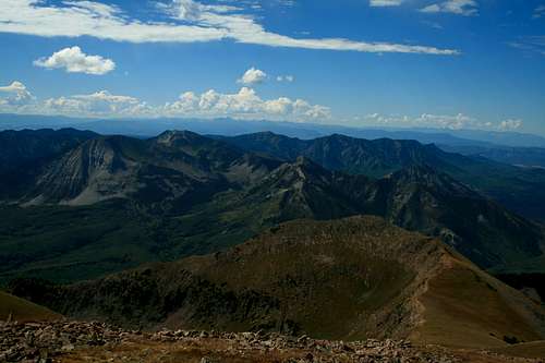
View from the Summit
The summit offers partial Elk and San Juan views, however the majority of the views are the interior of this area of the West Elks which have a very distinctive feel. On clear days views to the nortwest will stretch to the La Sals in Utah.
 Panorma submitted by SP member jfrishmanIII
 Getting There
To access the Sink Creek / Lone Pine trailheads:Starting from Crawford Colorado drive towards Crawford state park. Before crossing a bridge there is a road that leads to national forest access. Follow this road and then turn right towards the south side of Needle Rock. This is mostly a good quality, county maintained gravel road (although it gets icy and muddy during certain times of the year). Follow this road about five or six miles. Just before the end of the road a forest service road goes to the right (there are a couple and this is the last one). Once on this road go about a mile and turn left on another road. The trail head is not far. The last mile of this road can be very muddy during the spring. When the road is muddy it should be avoided. The total distance form Crawford is around 7 miles.
Access via Curecanti PAss via Bald Mountain Reservoir (Crystal Creek Road):
Starting from Crawford Colorado go south on HWY 92 for about 9 miles. There should be a forest service road going to the east (FR 713). Follow this road about another 9 miles. I have not driven the road and cannot comment on it's condition. I'm sure it should be avoided when muddy like the rest the roads in the area.
Red Tape
The 4WD drive roads in the area should be avoided when wet. The mud in the area is a really sticky adobe / clayish mix that can be really troublesome. The Sink Creek trail contains a lot of dead fall and some avalanche debris. Depending on the time of year there may not be much water available up high. There is a lot of cattle grazing in the area.Camping
There are no restrictions for camping in the national forest in this area. Crawford State Park offers the nearest developed camp sites in the immediate area and can serve as a good base camp to access the North Rim of Black Canyon NP. Fishing is available at Crawford State Park however in my experience catching is rare. Smith Fork Ranch offers a dude ranch sort of vacation if you are into that sort of thing.External Links
Gunnison National Forest.2250 Highway 50
Delta, CO 81416
(970) 874-6600
NWS Forecast for 9400 ft near Crawford Colorado.
It's the mountains and the weather can be different up high. Use good judgment.
Crawford State Park
For a guest ranch experience
Smith Fork Ranch
Mount Guero on listsofjohn.com
Routes
There is no short route to the summit. You can achieve the summit from the West ridge (via Sink Creek or Lone Pine trails) or South ridge (via Curecanti pass). I have heard reports of being able to gain the summit via the north ridge as well. See the getting there section for access to the base of the mountain.West Ridge via Sink Creek or Lone Pine Overview:
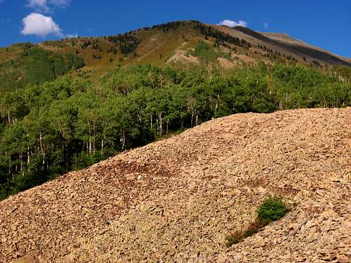
Sink Creek or Lone Pine trails can be used to access the base of the mountain from the Smith Fork area (west of the mountain towards Crawford). The Sink Creek trail is shorter. Both trails have a lot of dead fall and avalanche debris. The Sink Creek trail will loose elevation a couple times. The Sink Creek and Lone Pine trails intersect near a stream crossing at the base of the mountain. From here, you can pick a line and bushwhack /scramble to the west ridge. Another option that adds some distance but provides better footing is to ascend the drainage located off Lone Pine trail just south of the main west ridge. This drainage is just south of an obvious slide path. There are obvius game trails in this drainage. These routes should be around 13 miles and 5000 ft elevation gain RT.
You can clearly see the drainage in the following photo:
 Sink Creek Approach
Topo of the Sink Creek / Lone Pine Approach
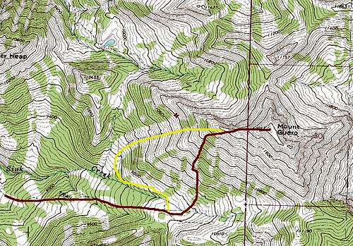 The route from Sink Creek trail
South Ridge via Curecanti Pass
The shortest access to Curecanti pass is via Bald Mountain Resevoir. This route ascends the South Ridge. Reports are that it is scarry loose down low. See the climbers log for details. This route may have less elevation gain but the length looks to be similiar to West ridge.
jfrishmanIII - Nov 9, 2007 7:16 pm - Hasn't voted
Another approachNice mountain to add, though the page could use some fleshing out. Another good route is to hike from Bald Mountain Reservoir to Curecanti Pass area and ascend the south ridge, though this does involve a very loose section. Ascending (or descending) the west ridge via Lone Pine Trail is probably feasible as well. Also, be warned that when I was there, the Smith Fork Road was in very bad shape, terribly deep ruts and lots of rocks. My old Subaru wagon made it with a struggle, but I definitely needed every inch of clearance. A sedan could have had real trouble.
ktimm - Nov 10, 2007 9:36 am - Hasn't voted
Re: Another approachThanks I will add that. I had thought that was an option but had never tried it