
|
|
Mountain/Rock |
|---|---|
|
|
39.50855°N / 106.61816°W |
|
|
Eagle |
|
|
Hiking, Mountaineering |
|
|
Spring, Summer, Fall, Winter |
|
|
12550 ft / 3825 m |
|
|
Overview
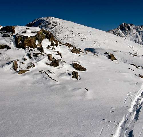 New York Mountain Summit, from west
New York Mountain is a 12,550 foot peak in the Northern Sawatch Range of Colorado. The highest point in the range is Mount of the Holy Cross at 14,005 feet/4269 meters.
More info on the Northern Sawatch Range can be found here.
Here is the SummitPost link to the greater Sawatch Range.
New York Mountain is located in the White River National Forest. It has 350 feet of prominence.
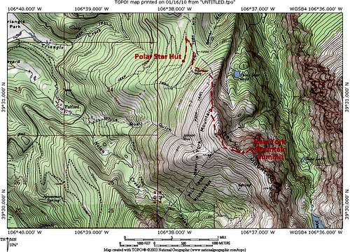
Here is a topo map showing the ski route we used to access the summit.
Getting There
Winter Access:
During the winter, New York Mountain is best accessed from the Polar Star Hut. Reservations for the hut can be made here.
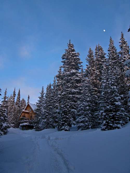 Polar Star Hut
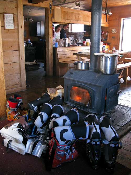
inside Polar Star Hut
It should be noted that there is also snowmobile access to the Polar Star Hut. We chose to use a different approach, on a separate skin trail. The Polar Star Hut is a great portal to the Holy Cross Wilderness. Additionaly, fine mountain biking trails abound near the hut.
Here are directions to the Polar Star Hut from two different trailheads. It is worth noting that we accessed the hut from the Yeoman Park Trailhead, which seems to be the most popular route. These Directions were taken directly from www.hutski.com:
Yeoman Park Trailhead
ELEVATION: 9,080 feet
HUTSKI.COM FREE TOPO MAP: Peter Estin Hut
GPS: 355 701 E, 43 74 052 N
HUTS ACCESSED: Peter Estin, Harry Gates
USGS 7.5 min. map: Fulford
10th Mountain Huts map: New York Mountain
Drive Interstate Highway 70 west from Vail or East from Glenwood Springs. Take the Eagle Exit (#147) and drive south .2 miles, cross a bridge over the Eagle River, take a right on old Hwy 6 and drive West a short distance to Eagle. Turn left (S) on Broadway (the main street) and continue to 5th Street.
Turn left (E) on 5th Street and continue to Capitol Street, turn right and drive until you reach the first stop sign. Turn left on Brush Creek/Sylvan Lake Road and follow it south from Eagle 10.4 miles to a "Y" in the road. Take the left fork (East Brush Creek Road) and drive 5.9 miles to Yeoman Park. Turn right (SW) off the main road, and drive a spur over a bridge crossing East Brush Creek, then continue a few hundred feet to obvious parking.
In winter you should use a high clearance 4-wheel-drive vehicle for travel to and from this trailhead. Tire chains or snow tires are also advisable. Any passenger car can do the drive in the summer, and it's a nice drive that provides access to a vast are of public land.
West Lake Creek Trailhead
8,220 feet
Hutski.com map: Polar Star Inn
USGS 7.5 min map: Grouse Mountain
10th Mountain Huts map: New York Mountain
GPS: 361 590 E, 43 83 621 N
Hut accessed: Polar Star Inn
Because of poor signage the drive to the West Lake Creek Trailhead is more intricate than most. Drive I-70 13 miles W from Vail or about 46 miles E from Glenwood Springs, and turn off at the Edwards Exit (Exit 163).
From the Edwards exit continue for a short distance across the Eagle River to a stop sign and T intersection with Highway 6. Turn right (W) and drive .7 miles to Lake Creek Road on the left. Drive the Lake Creek Road 1.8 miles to a well-signed Y intersection. Take a right (W) on the West Lake Creek Road and follow it 2.8 miles to a parking area where a switchback in the road makes a hard left. The Card Creek drainage trail follows a distinct snow-covered road southerly from the parking area. Four-wheel drive may be necessary to reach this trailhead.
Directions for skiing New York Mountain from Polar Star Inn
The following information was taken from the HutSki.com
DIFFICULTY: Intermediate to Advanced
HUTSKI.COM FREE MAPS: Polar Star Inn (see above)
TIME: Half day to full day
DISTANCE: 2 miles round trip
ELEVATION GAIN: 1,380 feet round trip
This popular summit climb gives you some honest mountain skiing and good views. Downhillers will like the turn options, but this terrain is above timberline, so be ready for dreaded trap crust.
Put your skins on at the Polar Star Inn, climb SE to timberline, then choose a route that intersects New York Mountain's north ridge. Follow the ridge to the summit. You'll want climbing skins for this route, and you'll probably end up walking up wind-scoured areas. Possible downhill skiing varies with snow cover. In general, try the west face (open areas drop down into the trees) or the upper part of White Quail Gulch.
SAFETY NOTES: Suddenly, this route takes you into alpine regions above timberline—a different environment than the forest below. Visibility can deteriorate rapidly and snow conditions can make downhill skiing all but impossible. There is steep avalanche terrain on the east side of the north and south summit ridges, as well as slide potential in upper White Quail Gulch. Also, given a load of extremely unstable snow, any of the slopes on New York Mountain could avalanche. Beware of cornices on all ridges.
Summer Access:
Nolan Creek Route
The following information was provided by ChicagoTransplant:
- Trailhead: Nolan Lake, Elevation 9900' Route: From the I-70 Eagle
interchange, head south to US 6, follow the signs through town for Sylvan
Lake State Park. Pass the Sylvan Lake State Park visitor center the road
will fork and become dirt, take the east (left) branch of the road now FS
415 and follow for 6 3/4 miles to just past the Yeoman Park Campground.
Turn left on FS 418 and follow for 3 1/2 miles to the town of Fulford.
There is parking for the trail at the intersection of FS 418 and the road
that leads Fulford. The trailhead is just up the road on the right.
- Trailhead: Upper Fulford, Elevation ~11,200' Route: From the Nolan Lake
Trailhead, continue on FS 418 as it climbs several side roads to a small
signed parking area. This is the trailhead.
- Trailhead: West Lake Creek, Elevation 9580' Route: From I-70 Edwards
interchange, head south to US 6, turn west (right) and follow to Lake Creek
Road. Follow south to a T-junction at 1 3/4 miles and turn right, continue
on this road for approximately 3 miles to the West Lake Creek Road (FS 423)
on your right. Two wheel drive cars should park here, 4WD can continue for
approximately 4 miles to 9580' and the signed New York Trail. The 4WD road
is described in "Guide to Colorado Backroads & 4-Wheel Drive Trails" by
Charles A Wells. The road is not difficult, but can be muddy when its wet."
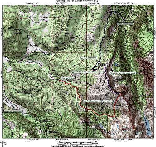 New York Mountain Summer Routes
Other Routes & Trailheads
The following info was taken from the 10th Mountain Hut website.
• Trailhead: Yeoman Park, elevation 9,060' Route: F.S. Road 418 to the hut, Total Mileage 9.1
• Trailhead: West Lake Creek, elevation 8,220' Route: F.S. Road 423, Trail 1876, then follow F.S. Road 418 to the parking area and entrance, Total Mileage 6.1
• Trailhead: Peter Estin Hut, elevation 11,200' Route: F.S. road 416, F.S. road 418 to the hut, Total Mileage 16.7
• Trailhead: Peter Estin Hut, elevation 11,200' Route: Trail 1873, F.S. road 415, F.S. road 418 to the hut, Total Mileage 13.5
Backcountry Dangers
As can be seen on the topo map, there are several mines in the vicinity of New York Mountain, including the hut's eponymous mine. These mines present a hazard when backcountry skiing.
Other typical backcountry skiing dangers also exist. Use standard caution, avalanche assessment, and backcountry knowledge.