


-
 4583 Hits
-
 85.36% Score
-
 20 Votes
|
|
Mountain/Rock |
|---|---|
|
|
45.66350°N / 7.41245°E |
|
|
Aosta Valley |
|
|
Mountaineering |
|
|
Spring, Summer, Fall, Winter |
|
|
10568 ft / 3221 m |
|
|
Note
|
La montagna chiama i suoi figli, ed essi rispondono fedelmente al suo appello… Osvaldo Cardellina, Diario alpinistico, 1964-65 Page texts: @ OsvaldoCardellina "Osva", passed away on May 2, 2022. Page owners: Christian Cardellina e Osvaldo Cardellina. Any updates from September 12, 2022: Antonio Giani, page administrator, friend and climbing companion. Testi della pagina: @ OsvaldoCardellina "Osva", scomparso il 2 maggio 2022. Proprietari pagina: Christian Cardellina e Osvaldo Cardellina. Eventuali aggiornamenti dal 12 settembre 2022: Antonio Giani, amministratore della pagina, amico e compagno di salite. |
Lakes Overview
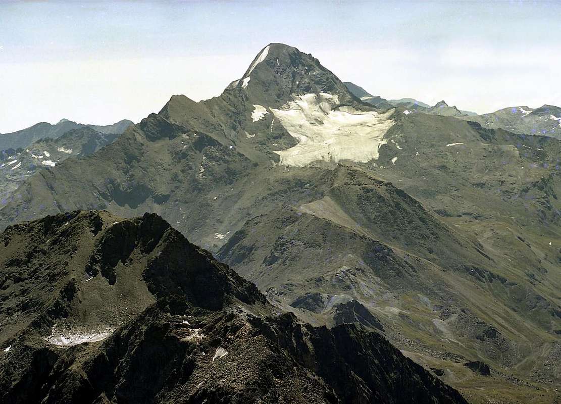 |
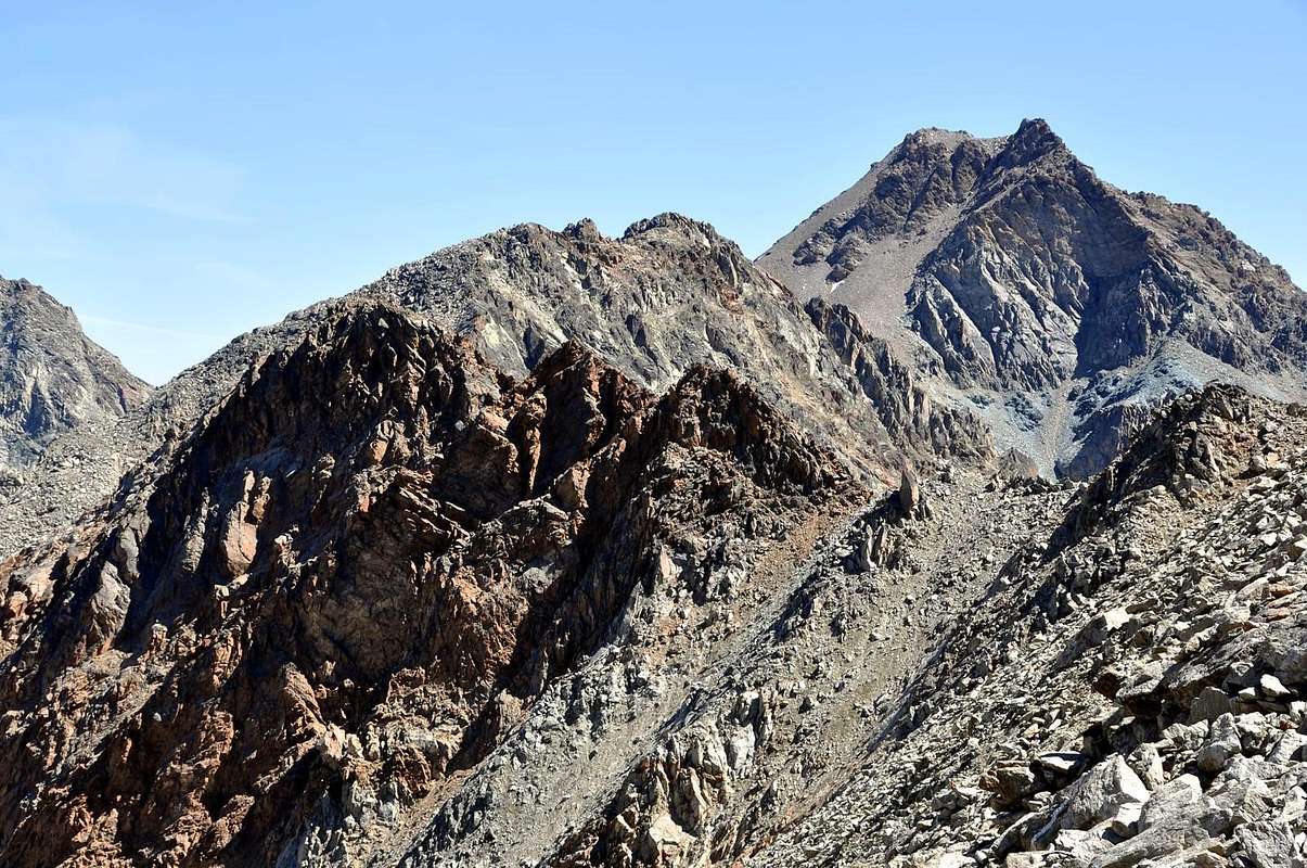
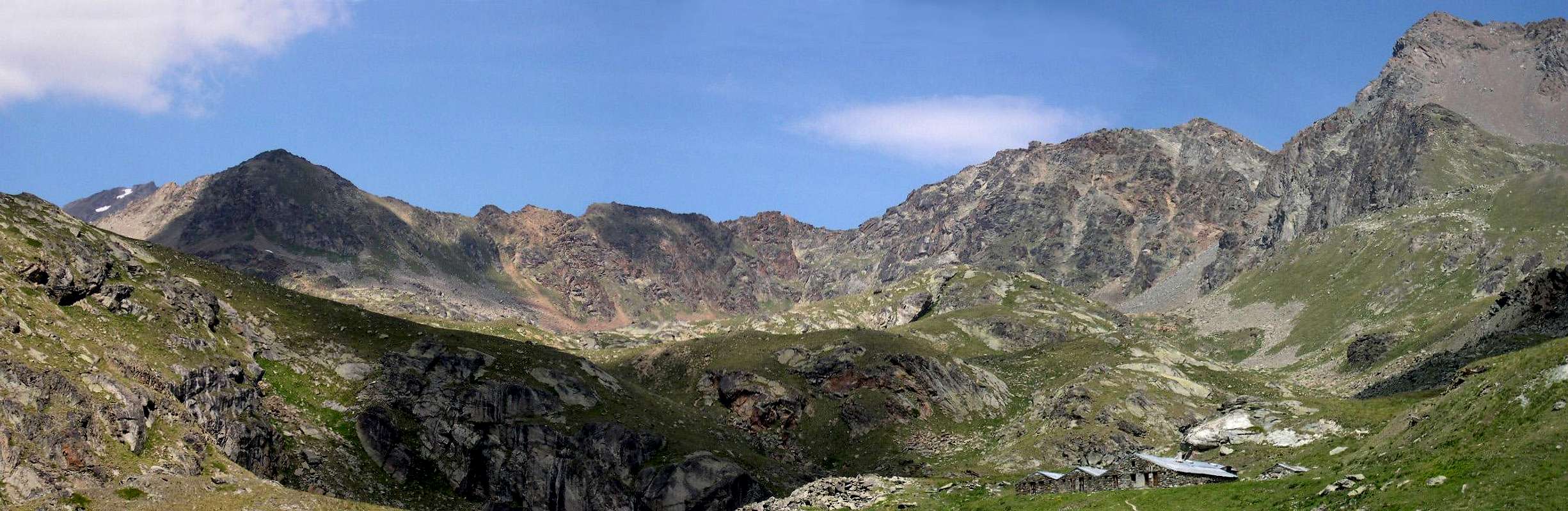
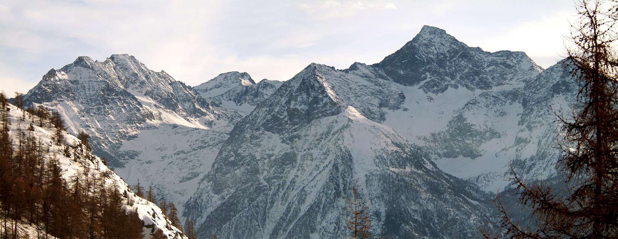
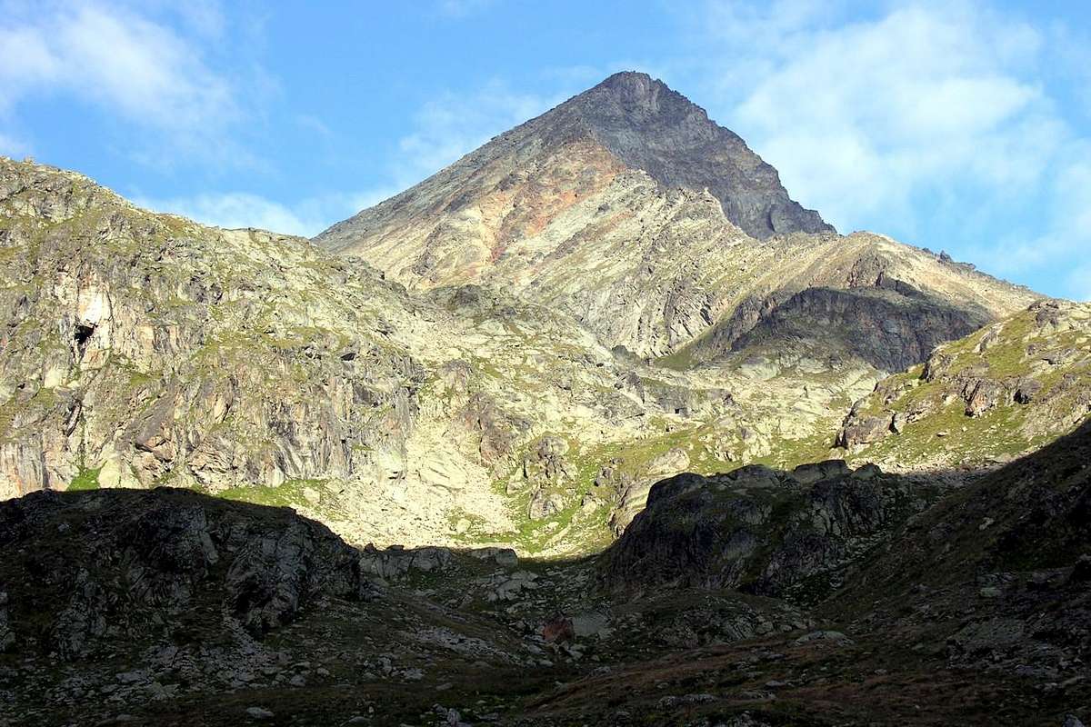
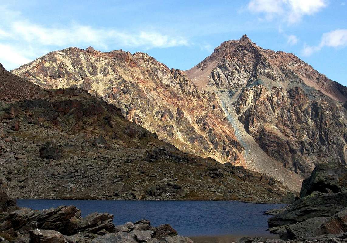
The long ridge dividing the Vallons Laures (to the North) and Grauson-Lussert joins, starting from the East or from the Tip Leppe (3.305/6m) in the West to the Eastern Summit of Punta Rossa of Emilius (3.400m), these two highest tested, the waters of which flow into the Dora Baltea and Grand'Eyvia Streams. We can divide this part into two sections: one that descends from the most Eastern Leppe to a rounded collar 3.181 meters (Lussert Pass) that precedes a Quote fairly important and clearly visible on both opposite sides. The same named Punta Lussert is listed by I.G.M. 3.221 meters, while newer maps (L’Escursionista "Cogne Valley n°10") attribute to the altitude of 3.216 meters. Further the ridge towards the West accepts first forming a headframe squared (Quote 3.189 meters) and then lose more altitude towards a series of four elevations and two carvings (in succession 3.110m, 3.094m, 3.011m, 3.079m, 3.093m, 3.066 meters) before reaching the round Mont des Laures (3.120m) and the Hill of the same name (3.035/6m). The second sector on the other hand, continuing Westward, including the Pointe des Laures (3.367m) and the East of three Punta Rossa. In fact, the Punta Lussert is a great and important shoulder of Leppe together which, in times past, dominated in the North of Glacier Laures (* not to be confused with that of Lussert at the foot of Tour Grauson/Pic Garin and both reduced today miserable thing), while to the South incumbent on Lac Dessus Lussert (Lower; (2.713m).
 |
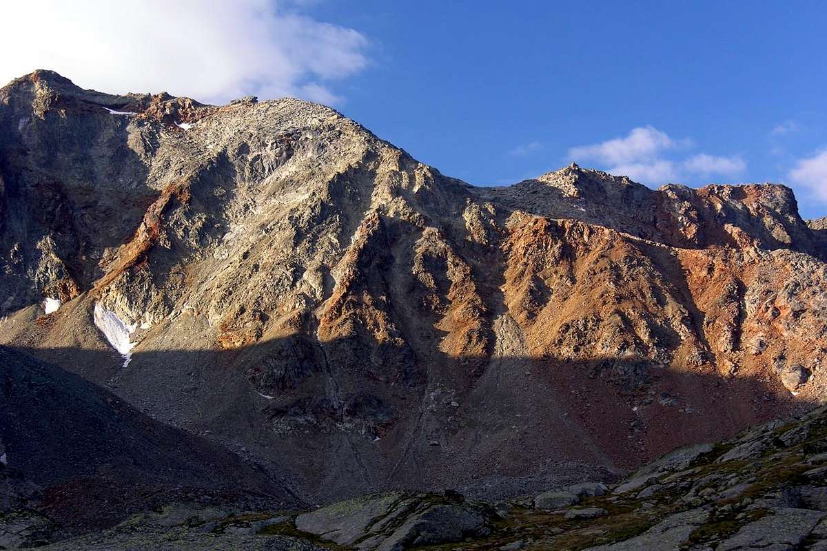
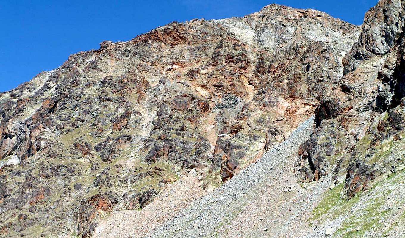
The structure of this mountain is then formed by a long ridge to the West, while its two sides are to the North a series of rock outcrops alternating with snow slopes which follow small goulottes; rushes towards the South with a rocky wall over 300 meters, engraved in its middle by a grassy gully debris broken by small ledges with potting soil. So in reality, this mountain is in a great Western shoulder to the Summit of the Leppe, so that viewed from the South almost merges with the same appearing as a mere continuation of its West Ridge. From the North instead "stands out" more as top in its own right, no doubt because most highlighted by the hill between the two that, while to the South appears to be small, hidden semi collar, from this side appears as large and round saddle. Conversely rugged ribs of rock alternating with snow couloirs more buckets not attract particularly those who rises from Laures Vallon. Almost certainly these are the main reasons, along with the fact that the higher Leppe offers a greater call for which has remained over time "abandoned-segregated".
 |
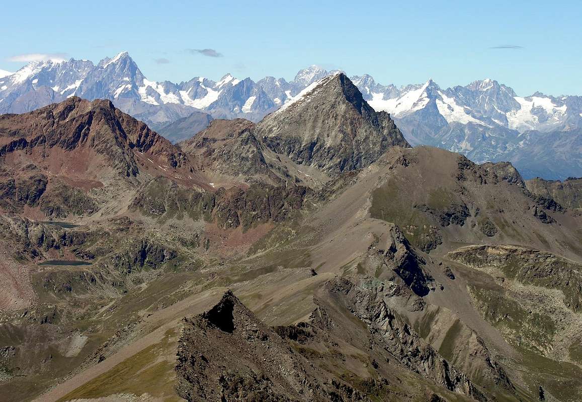
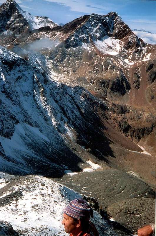
Even the climbing history of this ridge is quite strange, because the same is certainly poorly attended and recorded a few passages, only in the last thirty years, between the hill of the same name and Mont des Laures, while for the rest we rely on very little information that only the recent "explorations" have made it more concrete and reliable. Otherwise you have to rely on the passage of some fanciful hunter, which has never been seen in our day trips and perhaps belonging to another Epoch. Certainly among all the Top of this area of the Punta Lussert remains the most misunderstood and least attended: we generally confined to climb to near Mont des Laures to complete a trip to the lakes or, in the opposite direction, to the "classic "climb to the Leppe's Summit via the Saint Marcel Hill or Pass Vallonet; in rare cases, you will reach the same from Colle di Leppe via the Northeast Ridge. Otherwise, after the explorations of the end '800, you fall in anomynaty absolute and only passion against what is unusual has led in recent times to explore this mountain. The same, in this way "baptized" in the "Guide of Monte Emilius" 1978, he received the satisfaction of being so located and identified by both the I.G.M. Florence (clearance number 199 of November 28th, 1978) and more recently by the Charter "Cogne Gran Paradiso - Valsavarenche Map", 1: 25.000. A recognition that gives the "dignity" in this small and mistreated Summit. However, she also, some "lover", at least with regard to exploration, it is; but nothing more because of these ridges, Mont des Laures excluded, you can not see and do not meet anybody. But for those who love the lonely spaces and the deep silence is also so beautiful and I certainly would not change places with the most famous but over-crowded. Who shall ascend this Summit will surely find little glory, but great gratification in the Spirit. To counter this Summit offers a splendid view of the two walloons mentioned above with exceptional quick glances on both Lakes Laures than on Lussert, as well as special views on the Group of Emilius, and just in the distance to the South of Chain Gran Paradiso and to the nearby Grivola. More in particular, have to admire the nearby Grauson Tower and Garin Peak in the Southwest, while to the North stretches the Chain of Rouèses from Punta Ilario Antonio Garzotto to Becca/Tower of Salé, above Brissogne.
 |
La lunga cresta spartiacque tra i Valloni di Laures (a Settentrione) e di Grauson-Lussert unisce, partendo dall’Est ovvero dalla Punta di Leppe (3.305 m) ad Ovest fino alla Punta Orientale della Punta Rossa dell’Emilius (3.400 m), queste due alte testate, le acque delle quali scorrono verso la Dora Baltea e la Grand’Eyvia. Possiamo dividerlo in due settori: uno più Orientale discendente dalla Leppe ad un arrotondato colletto 3.181 metri (Colle di Lussert) precedente una Quota abbastanza importante e ben in vista su di entrambi gli opposti fronti. La medesima nominata Punta di Lussert viene quotata da I.G.M. 3.221 metri, mentre carte più recenti (“L’Escursionista”) le attribuiscono l’altitudine di 3.216 metri. Oltre e verso Ovest la cresta declina formando dapprima un castelletto squadrato (Quota 3.189 metri) per poi perdere maggiormente altitudine verso una serie di quattro elevazioni e due colletti (in successione 3.110 m, 3.094 m, 3.011 m, 3.079 m, 3.093 m, 3.066 metri) prima di raggiungere il tondeggiante Mont des Laures (3.120 m) nonché l’omonimo Colle (3.035/6 m). Il secondo settore invece, continuando verso Occidente, comprende la Punta des Laures (3.367 m) e la Punta Est della Rossa. In realtà la Punta di Lussert costituisce un significativo spallone della Punta di Leppe insieme alla quale, nei tempi andati, dominavano a Settentrione il Ghiacciaio delle Laures (* questi é da non confondersi con quello del Lussert ai piedi di Tour Grauson/Pic Garin ed oggidì entrambi ridotti a ben misera cosa), mentre a Sud incombono sul Lago di Lussert Inferiore (2.713 m). La struttura di questa montagna è quindi formata da una cresta allungata verso Occidente, mentre i suoi due versanti presentano verso Nord una serie di costole rocciose alternate a pendii di neve ai quali seguono delle piccole goulottes; verso Sud precipita con una muraglia rocciosa di oltre 300 metri, incisa nella sua metà da un canalone erboso detritico spezzato da piccole cengie con terriccio. Quindi in realtà questa montagna consiste in un grande spallone ad Occidente della Punta di Leppe, tanto che vista da Sud quasi si confonde con la medesima apparendo qual semplice continuazione della sua Cresta Ovest. Da Settentrione invece "spicca" maggiormente come sommità a se stante, sicuramente perché maggiormente evidenziata dal colle tra le due che, mentre a Sud appare come piccolo e semi nascosto colletto, da questo versante appare qual larga e tondeggiante sella. Per contro aspri costoloni rocciosi alternati a canaloni di neve sempre più secchi ed esposti alla caduta di pietre fan si da non attrarre chi sale dalle Laures. Quasi sicuramente son queste le ragioni principali, insieme al fatto che la Leppe più elevata offre maggior richiamo, per le quali é rimasta nel tempo "abbandonata".
 |
Anche la storia alpinistica di questa cresta è alquanto sconosciuta, anche perché la medesima è sicuramente scarsamente frequentata e registra qualche rado passaggio, esclusivamente nell’ultimo trentennio, tra il Colle di Laures e l’omonimo Mont, mentre per il resto necessita d’appoggiarsi a ben scarse notizie che solo le recenti “esplorazioni” han reso più concrete ed affidabili; altrimenti bisogna credere nel fantasioso passaggio di qualche cacciatore, peraltro mai visto nelle nostre escursioni e forse appartenente ad altra Epoca. Certamente tra tutte le Sommità di questo comprensorio la Punta di Lussert rimane la più misconosciuta nonché la meno frequentata: in genere ci si limita alla salita al vicino Mont des Laures a completamento di un'escursione ai laghi, oppure, in direzione opposta, alla "classica" salita alla Punta di Leppe tramite il Colle di Saint Marcel od il Passo del Vallonet; in casi più rari si raggiunge la medesima dal Colle di Leppe tramite la Cresta Nordest. Altrimenti, dopo l'esplorazioni di fine '800, si cade nell'anominato più assoluto e solo la passione nei confronti dell'inusuale ha portato in tempi recenti ad esplorare questa montagna. La stessa, in siffatta maniera "battezzata" in "Guida del Monte Emilius" 1978, ha ricevuto la soddisfazione d'esser così collocata ed identificata sia dall'I.G.M. di Firenze (nulla osta n° 199 del 28 Novembre 1978) e più recentemente dalla "Gran Paradiso Cogne - Valsavarenche Map", 1:25.000. Un riconoscimento donante "dignità" a questa bistrattata Cima. Ciononostante, pur lei, qualche "amante" lo trova, almeno dell'esplorazioni poiché da queste parti, Mont des Laures escluso, proprio non incontri anima viva. Ma per chi ama gli spazi solitari ed i silenzi profondi é bello anche così. Per contro questa offre uno splendido panorama sui due valloni sopra citati con colpi d’occhio eccezionali sia sui Laghi delle Laures che sui Lussert, nonché viste spettacolari sul Gruppo dell'Emilius ed appena più in lontananza verso Mezzogiorno sulla Catena del "Granpa" compresa la vicina Grivola. Ma particolarmente possono ammirarsi in direzione Sudovest la Tour Grauson ed il Pic Garin, mentre a Nord si distende la Catena delle Rouèses, dalla Punta I.A. Garzotto insino alla Becca/Torre di Salé, sopra Brissogne.
 |
First Ascents
- First on the Summit: Agostino Ferrari with Cogne Mountain Carrier B. Glarey; Sep 15th, 1898, in ascent from Les Laures Alp, Vallon, Glacier with subsequent crossing.
- In winter: unknown.
- North Edge of Quota 3.221m: Osvaldo Cardellina, lone; Oct 19th, 2006, in ascent from Les Laures/Leppe Vallons and subsequent traverse to three Leppe Summits.
- North Face of Quota 3.189m or Lussert's Little Castle and final West Crest: Osvaldo Cardellina, lone; Nov 29th, 2007, in ascent from Les Laures/Leppe Vallons.
- North-northwest Spur of Quota about 3.180m or Lussert's Western Shoulder: Osvaldo Cardellina, lone; Oct 19th, 2006, in descent from Leppe Summit.
- North Face of Carving 3.094m and West Crest: Agostino Ferrari and B. Glarey; Sep 15th, 1898, in ascent from Les Laures Alpage with traverse on ridge.
 |
- Western Ridge (partially) from Collar 3.094m: Agostino Ferrari and B. Glarey; Sep 15th, 1898, in ascent from Les Laures Old Alp, Vallon and Glacier.
- W-SW Arête (Integral crossing to Punta di Leppe from Laures Pass): Osvaldo Cardellina, lone; Jul 12th, 1988), in ascent from Old Gimillan Village.
- W-SW Arête (Integral from Lussert Summitt to Mont des Laures and Hill): Osvaldo Cardellina, lone; Nov 29th, 2007), with crossing East/West.
- South Wall (Central Couloir): Osvaldo Cardellina, Marco Cossard and Giuseppe Lamazzi; Jun 29th, 1973, in descent from Leppe Western Summit.
- South Wall (right of Central Couloir): Osvaldo Cardellina, lone; Apr 24th, 2007, in ascent from Tzesère Alp with traverse to Leppe by N Edge.
- East Crest (to Lussert Collar): Agostino Ferrari and B. Glarey; Sep 15th, 1898, in descent from the Summit with traverse towards Gr. Roise.
- East Crest (from Lussert Collar): Cardellina, Marco Cossard and Giuseppe Lamazzi; Jun 29th, 1973, in ascent after the descent from Leppe.
 |
Getting There
BY CAR:- From Turin or Milan: Motorway A5. Exit in Aosta Ovest. Drive to the near Aymavilles; follow in the direction of Cogne Valley. Or Exit Aosta East to Gr. Brissogne and St. Marcel. From Switzerland: through the Grand St. Bernard Tunnel or the homonym Pass). Drive to Aosta, then follow Courmayeur direction on SS.26. Just after Sarre, turn to the left, in the direction of Cogne Valley. Also continue East towards Grand Brissogne and Saint Marcel, turn to the right near the brige above Baltea, neighbor Quart-Villefranche. From France: through Mont Blanc Tunnel or Petit St. Bernard Pass). It isn't necessary to enter in Motorway A5, you can drive through SS.26 Aosta direction. Before arriving at the Village of Sarre, follow the sign and turn right towards Valle di Cogne; also passing the town continue East to Quart Municipality.
Specific Roads:
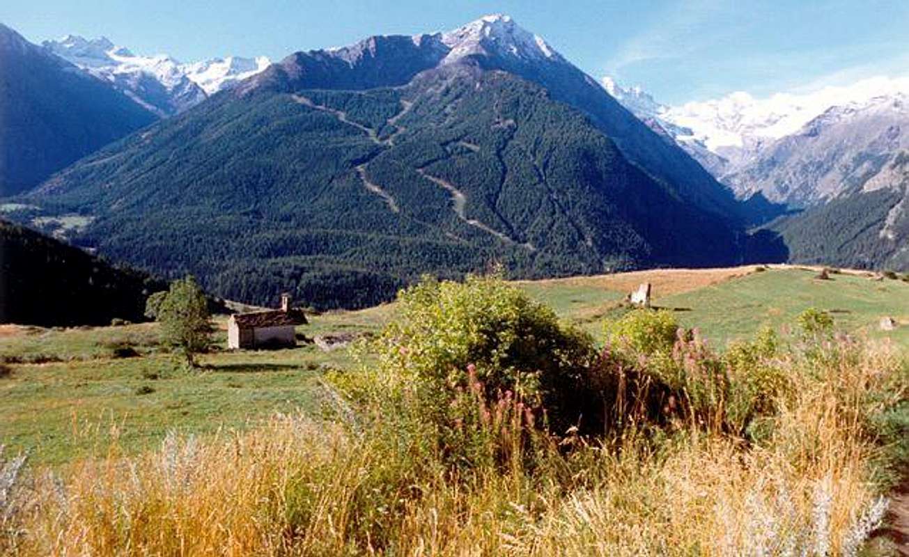
- a) - After Aymavilles, the SR.47 crosses the Villages of Vieyes, Epinel and Crétaz and after about 25 Km. arrives at Cogne (1.534m). Follow the road signs for Gimillan and Lillaz; arrived at a round-about, recently built in proximity of the St. Anthony Chapel, go left along the scenic route leading to the Villages of Montroz and Gimillan (1.787m); 1,5 and 3 Km. after Cogne. Usually no parking problem neeighbor the bell tower of a little chapel in center, also near the bridge above Gimillan Torrent (small parking).
- b) - Exit out on Motorway A5 Aosta East (near Nus) to Grand Brissogne and Saint Marcel Communes; leaving East the Municipal Roads to the last, continue South on Regional Road to the the first at the beginning of Laures Vallon. From this go up through the private dirt road (no transit by cars) to Gremonenche Pasture and L'Arp (1.310m).
BY PLANE: Aeroporto "Corrado Gex" Saint Christophe (Aosta).
Approaches
APPROACH from South or Cogne Resort, through Grauson/Lussert/Tsesère Vallons
 |
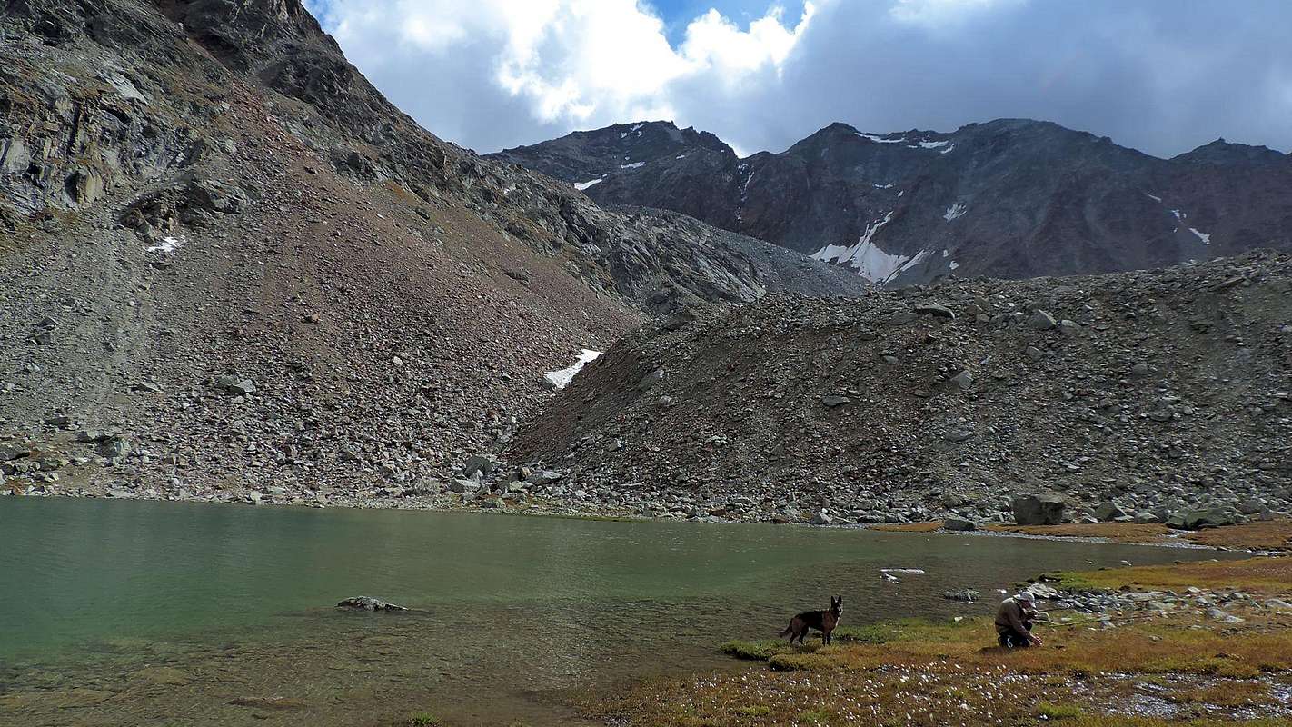
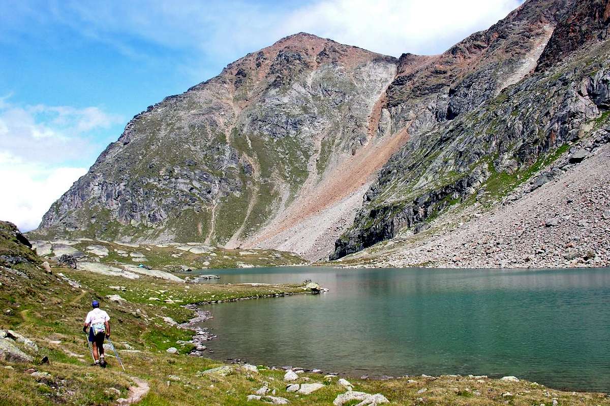
A) - From Gimillan (1.787m): go right starting from the car park (1.800m~) of Gimillan: after few meters the indications to Lakes of Lussert, St. Marcel Hill are found. The pathway is indicated by the yellow circle 9A and by yellow strips marked on stones along the route. The path begins going immediately uphill, then the slope decreases as we go beyond Révènti Alp (1.906m; ruines) and a little Chapel dedicated to the Virgin (1.836m). Soon the path resumes to go up and splits in two, before it begins to penetrate into the Grauson Vallon: it's possible to continue following the right one that goes down as far as the small Bridge of Ecloseur Pastures (1.904m; shop-sign Tchezeu Alp; 1.918m), but in such a case we must go up again; it's better to follow the left one that, in practice without losing height, arrives at the bridge under the Alp of Pila (2.025m), cross it and, following the stepped pathway, overcome the rocky bastion beside a fine waterfall (to the left). At this point the path turns right markedly, entering, high on the torrent, into a small vallon; by an alternation of steep and slight slopes, it reaches a panoramic cross, on the edge of a pleasant plateau. The path goes through the meadows, slightly descending: after the Old Grauson’s Pastures (2.271m), crosses the Doreire Torrent on the small bridge and by a steep trail beside the stream, reach the wide upper part of the Grauson Valley. At the junction before Pralognan Pasture (about 2.400m), instead of going straight ahead along the pathway n° 4 leading to the head of Grauson/Doreire/Tessonet Walloon, go left (North) till to New Pasture (2.540m), where once there was the burned Tentori Bivouac, on Summer 2000. Along grassy slopes and great blocks, after a small promontory, by path toward the Lussert's Lower Lake (2.721m; 3h'00/3h'30). Or shorten the route going more towards North Alp Tsesère (2.645m; 0h'15 in less).
 |
A) - Da Gimillan (1.787 m): partire dal parcheggio (1.800 m~) trovando dopo pochi metri I "panneaux" con le indicazioni per I Laghi Lussert, il Colle di Saint Marcel o Corona. Scegliendo quello giallo/nero cerchiato con l'indicazione 9°. Il sentiero inizia salendo immediatamente in ripida salita per poi diminuire in pendenza andando verso l'Alpe Révèntì (1.906 m; rovine) ed incontrando subito dopo una Cappelletta dedicata alla Vergine (1.836 m). Subito dopo il sentiero riprende a salire con falsopiano e dividendosi in due presso un grosso cartello indicatore con piccola tettoia; tenendosi sulla destra (Est) penetrare nel Vallone del Grauson e, tramite una breve discesa, raggiungere il Ponte dell'Ecloseur (1.904 m; cartello indicante l'Alpe Tchezeu; 1.918 m). Attraversarlo sul Torrente Lussert e, lasciate le Alpi Ecloseur appena a destra, con un lungo diagonale a sinistra ed in mezzo ai prati raggiungere la successiva di Pila (2.025 m), con alla sua sinistra una bella cascata. Superare la soprastante bastionata rocciosa doppiandola a sinistra per poi ritornare a destra passando alti sul torrente in una valletta; con pendenze alternate e lievi raggiungere una croce su un promontorio panoramico. Il sentiero attraversa la prateria in leggera discesa: dopo Grauson Vecchie o Dessous (2.271 m) attraversa sul ponticello il Torrente Doreire e con un ripido percorso accanto al torrente raggiunge la parte larga e superiore del Vallone del Grauson. Verso la congiunzione prima dell'Alpe di Pralognan (2.400 m~), invece di progredire direttamente lungo il sentiero n° 4 che abbandona la testata del Vallone di Grauson/Doreire, girare a sinistra (Nord) sino all'Alpe di Grauson Nuove o Dessus (2.540 m), ove esisteva il Bivacco Tentori andato a fuoco nell'estate del 2000. Attraversando pendii erbosi ed un'area di grandi blocchi, dopo un piccolo promontorio, pervenire su tranquillo sentiero al Lago di Lussert Inferiore (2.721m; 3h'00/3h'30). Altrimenti, onde abbreviare il tragitto, tenersi tramite un sentierino lungo il torrente più verso Nord in un valloncello adducente all'Alpe di Tsesère (2.645 m; 0h'15 in meno).
APPROACHES From South Gimillan Hamlet & North or Grand Brissogne Municipality
 |
B) - Starting from Grand Brissogne-Primaz (894m): go along the road till the Gremonenche Alp (1.000m). From here along the dirt road up to l'Arp (1.310m) at the end of the same; then, along a path that, bordering the stream (Des Laures Torrent), leads to La Vieille (1.623m) and to Le Tramail or Tramouail (1.951m; intermediate pasture for cows, good shelter when weather is bad, always open). Crossing some small wooden bridges up to the altitude around 2.200 meters, (starting from this point a steep but faster path goes, at right (West), toward the slopes of Becca di Seneva. Better go on toward East forwarding the Becca di Salè (called Black Fountains) and climb the last 400 meters on wide slopes till the top of the great rocky terraces (2.600m) (here a small chapel dedicated to two brothers "Dino" and Jean Charrey and Cino Norat dead in 1929 on the East Wall of Monte Emilius). A short descent leads to the Refuge Ernesto Mènabreaz, partisan by Nazi-Fascist execution firing squad (2.542m, private); the refuge has an open free part (with covers, wood-burning stove and provisioning) usable as winter room (8 places), on the Eastern bank of Laures Lower Lake. From here toward South getting, after a short step in East of with the same name alp, the of Laures Long Lake (2.630m). Walk all along the Western bank always on the same path that fast becomes a track turning toward the lower part of the morenal tableland in quota 2.763 meters, near Montet Torrent. Go up toward fork 2.933 meters, nearby a mini-tiny lake; leaving in right (West) the two paths to Arbolle and Three Capuchins Passes, continue by winding route amongst great blocks, rubbles, debris reaching easily Laures Pass (3.036m; 1h'30 refuge).
 |
B) - Da Gran Brissogne-Primaz (894 m): salire lungo la strada poderale verso l'Alpe di Gremonenche (1.000 m) trovando il cartello di divieto presso il Villaggio di Luin. Da qui sempre per mezzo della medesima raggiungere l'Alpe di L'Arp (1.310 m) al termine della stessa) ; poi, con il sentiero fiancheggiante il Torrent des Laures, le successive di La Vieille (1.623 m) e di Tramail o Tramouail (pascolo intermedio per le mucche; ottimo ricovero in caso di cattivo tempo; sempre aperto; 1.951 m). Attraversando alcuni ponticelli in legno, raggiungere la quota di circa 2.200 metri (partendo da questo punto si snoda verso destra (Ovest) in direzione delle pareti della Becca di Seneva un sentiero più ripido ma anche più veloce nel prender dislivello). Migliore è la salita però portandosi ad Oriente contro la Becca di Salé (cosiddetta Via delle Fontane Nere) risalendo gli ultimi 400 metri su larghi pendii adducenti a grandii terrazzamenti rocciosi (2.600 m; piccola Cappella dedicata ai due fratelli Alessandro "Dino" e Jean Charrey ed a Cino Norat, caduti nel 1929 sulla Est dell'Emilius). Una piccola discesa porta al Rifugio Ernesto Ménabreaz, intitolato al partigiano fucilato dai nazi/fascisti (2.542 m; privato ma con un locale sempre aperto per gli alpinisti e attrezzato con 8 posti letto, coperte, stufa a legna e vettovagliamento), posizionato sulla sponda orientale del Lac Dessous des Laures. Da questi progredendo vero Sud con un sentierino, oltrepassando a sinistra dell'omonima alpe, raggiungere il Lago Lungo (2.630 m) e, continuando sulla sua sponda Occidentale, lasciando a Sudest sotto la Cresta Sudovest della Grande Roise la via che conduce al Colle di Leppe, sempre tramite sentiero raggiungere verso Sud-sudovest la spianata morenica a quota 2763 metri, vicino al Torrent Montet. Quando si tramuta in traccia, risalire al bivio 2.933 metri, presso un minuscolo laghetto; lasciando ad Ovest le vie pel Colle d'Arbolle e verso il Passo dei Tre Cappuccini ed Emilius, continuare con percorso sinuoso tra grandi blocchi, frantumi e detriti raggiungendo facilmente il Col des Laures (3.035/6 m; 1h'30 dal rifugio).
From South (Grauson Vallon, Lussert branch)
Through Approach A) - to reach the New Grauson Pasture and, having crossed twice the Torrent de Lussert, reaching the Lower Lussert Lake, located at the foot of the homonymous Southern Summit and in West to Leppe Top and the above Tip Tsesère (3.108m). From this point there are two possibilities of climb, discarding beforehand those to reach the watershed between this and the Mont des Laures (3.120m) or rise to the rocky couloir of the South wall, since treacherous for the presence of grass on the rock:
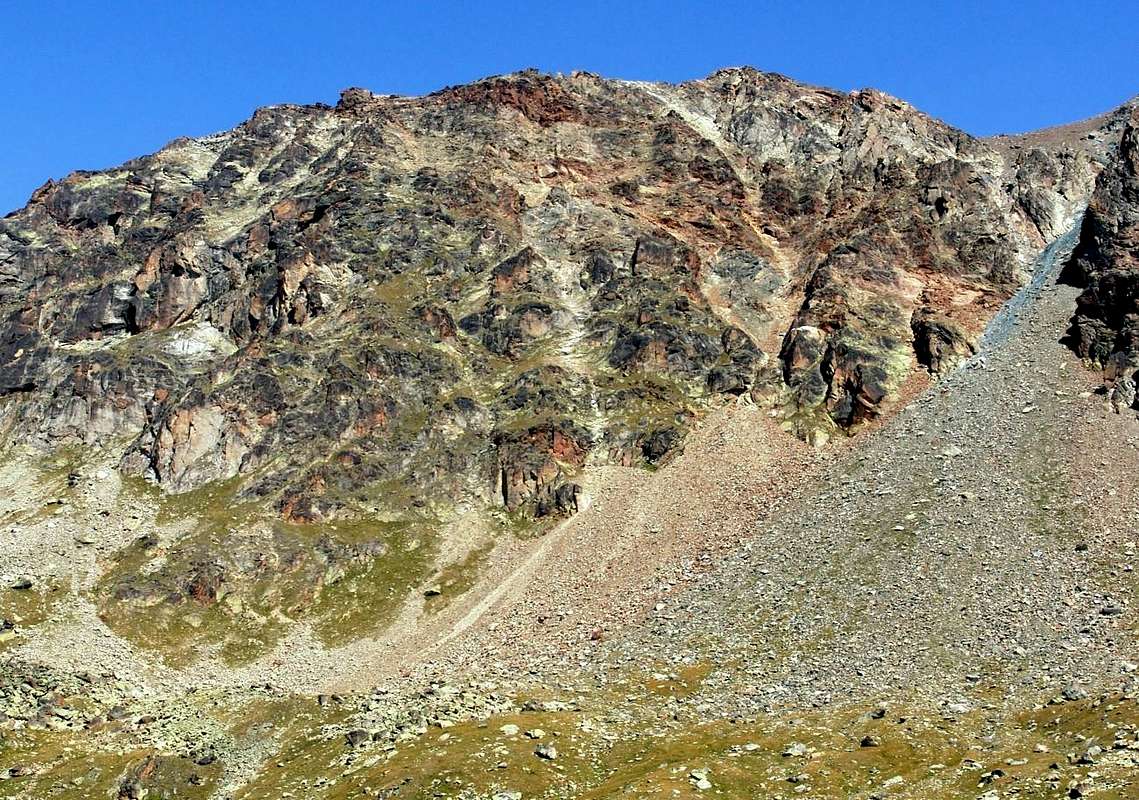
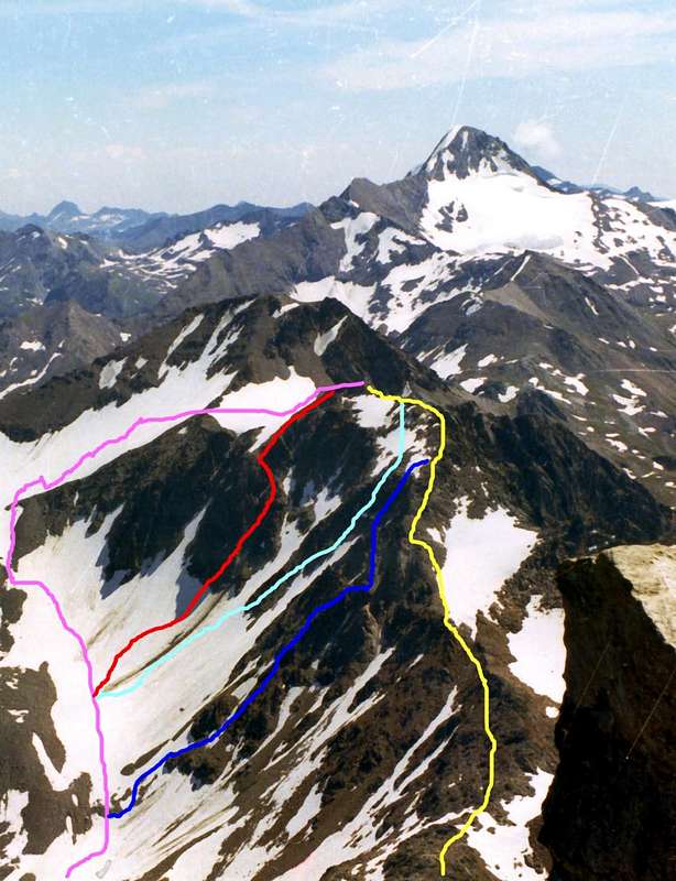
1) - go through the path to the Northwest reaching progression in the other two lakes Lussert and Pass (3.035m); this proceeding on the watershed to the East and, after overtaking the Mount of Laures, overcome the three successive roughness (3.093m, 3.111m, 3.110 meters) of the ridge and its carvings (3.066m, 3.079m, 3.094 meters), reaching the Quota 3.189 meters, with a small "castle" rocky, and immediately after the true Summit (EE/A; F+/PD; 2h'15/2h'45 from the hill; 7h'30/8h'00 starting from Gimillan).
2) - from Lower Lake abandon the path and keep going around the same through rocks to the North-northeast, reaching 2.900m in altitude about the entrance of the narrow and steep rocky channel that goes between the Western Leppe Antesummit (about 3.285 meters) and the Punta Lussert left to reach the with the same name Collar (3.181m). During the ascent of the same should not remain in its midst, but it is better to put on the sides to avoid the falling rocks, reaching a large boulder that bisects the narrowing, beyond which gradually bend to the left (Northwest). From the small pass, leaving just below a tiny lake in the North "born" for a short time, turn left and through fairly steep scree to reach the Summit via the short East Crest, consisting of stacked blocks (A; from F to F+; 1h'15/1h'30 Lower Lussert Lake; 4h'30/5h'15 by Gimillan).
Da Sud (Vallone del Grauson, ramo di Lussert)
Tramite l’Avvicinamento A) - raggiungere l’Alpe di Grauson Nuove e, dopo avere attraversato due volte il Torrent de Lussert, raggiungere il Lago Inferiore, posto alle pendici Meridionali dell’omonima punta ed a Ovest della Punta di Leppe e della soprastante Punta di Tsesère (3.108 m). Da questo punto esistono due possibilità di salita, scartando a priori quelle di raggiungere lo spartiacque tra questa ed il Mont des Laures (3.120 m) o di salire per il canale della Parete Sud, poiché infidi per la presenza di erba sulla roccia:
1) - continuare tramite il sentiero verso Nordovest raggiungendo in progressione gli altri due Laghi di Lussert e Colle (3.035 m); da questo procedere sullo spartiacque verso Oriente e, dopo aver scavalcato il Mont des Laures, superare tutte le tre successive asperità (3.093 m, 3.111 m, 3.110 metri) nonché i relativi intagli della cresta (3.066 m, 3.079 m, 3.094 metri) raggiungendo la Quota 3.189 metri, a mò di "castelletto", e subito dopo la vera Sommità (EE/A; da F+ a PD; 2h'15/2h'45 dal colle; 7h'30/8h'00 da Gimillan).
2) - dal Lago Inferiore abbandonare il sentiero ed aggirando ad Occidente il medesimo continuare tramite pietraie verso Nord-nordest raggiungendo in altitudine 2.900 metri circa l'imbocco dello stretto e ripido canale pietroso che sale tra l'Antecima Occidentale di Leppe (3.285 metri circa) e la Punta di Lussert a sinistra pervenendo all’omonimo Colletto (3.181 m). Durante la salita dello stesso conviene non restar nel suo mezzo, bensì è meglio appoggiare sui lati onde evitare la caduta di pietre arrivando ad un enorme masso che divide in due la strettoia, oltre il quale piegare progressivamente sulla sinistra (Nordovest). Dal Colletto, lasciando appena in basso a Nord un laghetto “nato” da poco tempo, voltando a sinistra raggiungere la Cima tramite la breve Cresta Est, formata da blocchi accatastati (A; da F a F+; 1h'15/1h'30 dal lago; 4h'30/5h'15 da Gimillan).
 |
From North (Les Laures and Leppe Vallons)
From the North Slope, there are several opportunities to climb, but the same are sometimes complex and in some cases dangerous and exposed to falling stones; this factor is highlighted more since he had the progressive withdrawal of snowfall blankets as well as the complete disappearance of the Glacier Laures as well as that of the only Glacier of existing or Leppe, at the base of the Tips Leppe/Lussert and now reduced in effect "permafrost". Absolutely and a priori excluded these as just said, among other denote three chances to climb with the characteristic of being long but safe, going through completely opposite directions or from Northeast (Leppe small Vallon) also Northwest (Laures):
1) - the first, definitely the best from personal experience, is to come up with the Via of Leppe Hill (3.110m) up to a around hundred metres from same and then turn to the Southwest and, beyond the Northern Edge of Leppe Summit, with short descent on scree reach the tiny lake arisen recently just below the Collar Lussert; by using this easy and short Northeast Slope reach in brief the Summit always through steep reddish scree. Otherwise, passing to the East through most large rocks, from the hut with Approach B)- continue to the South shore of Long Lake Laures (2.630m). From this point a small trace of the path up towards Southeast and, after rounding the great West-southwest Ridge of the Great Roise (3.357m) is directed to the hill. Reached the altitude of around 3.000 meters and left a minuscule lake in the North, to abandon this path and, through snowfields and rocky debris at the base of the North Slope of Punta Leppe, easily reconnect to the above (EE /A; from F to F+; 2h'30/3h'00 from the Menabreaz Shelter).
VARIANT: from the Long Lake along instead of supporting against the Great Roise continue Southward through the path to the Passes des Laures, Abolle and of Trois Capucins with Approach B)-; reached the point of 2.763 meters above sea level in a grassy esplanade at the Torrent de Montet, where the same fold more in the Southwest, leave the path addressing to the East-southeast. Climb up the steep terminal moraine, leaving traces in the North down to an another very tiny lake (2.724m); after this stretch between large blocks in the balance, continue in a small walloon on less steep snowfields and divided by some bottlenecks that come from the overlying rock walls of the Quotas 3.110m, 3.189m, 3.221 meters or Punta Lussert rejoining at an altitude about 2.950 meters to the previous path. This route is less tiring and boring than the last, but requires you to go up to a certain distance from the rocky walls of the danger of falling rocks (more or less the same time). Recommend the first uphill, the second downhill, waves vary.
2) - addressing ever more towards the Southwest through the main Vallon of the Laures, the second option is to walk the path of the first climbers of 1898 that the Laures reached the crest to trough 3.084 meters of the Old Map I.G.M. (probably in 3.093m or 3.066 meters closer to the current just after the Mont des Laures, in our opinion leaning toward the latter as the lowest and most easily accessible) and then navigate on the same Eastward bypassing the various altitudes and carvings. In this case, continue with the path to the Col des Laures up to an altitude around 2.933 meters, where the same splits by sending a branch to the West-northwest towards the Col d'Arbolle; abandoning both deviations and passing a trace of the secondary path, move towards the Mont des Laures. Doubling to the left its short and dark North Wall, climb up the ridge through one of two rocky couloirs that descend from the depressions mentioned above, with preference for the former (EE; F+/PD-/PD; 1h'45/2h'15 shelter and another hour and a half or two for the ridge). "Historical" route performed at the end of the '800, which is a fairly easy good shortcut, probably has not been repeated.
3) - otherwise continue with the same path up to the Col des Laures (3.035/6m); this cover also the first part of the ridge which, after passing to the right a rocky "cannon" top around thirty meters through an oblique ramp in the South, reaching the nearby Mont des Laures (3.120m), through rocks by alternating reddish or brownish color; by the same down quite easily to the underlying depression 3.066 meters and by this way continue with the previous (F+/ PD-/PD; calculate 1h'00/1h'10 more).
 |
 |
 |
 |
 |
Da Nord (Vallone delle Laures e Valloncello di Leppe)
Dal Versante Nord esiston diverse opportunità di salita, ma le medesime risultano a volte complesse ed in altri casi molto pericolose e notevolmente esposte a caduta di pietre; questo fattore s’evidenzia maggiormente da quando si è avuto il progressivo ritiro delle coltri nevose nonché la totale scomparsa del Ghiacciaio delle Laures e quella dell’unico esistente ovvero di Leppe, posto alla base delle Punte di Leppe/Lussert ed oggi ridotto in effetto “permafrost”. Assolutamente ed a priori escluse queste per quanto appena detto, tra le altre indichiamo tre possibilità di salita con la caratteristica d’esser lunghe ma sicure, salendo tramite direzioni completamente opposte (Valloni di Leppe o Laures):
1) - la prima, sicuramente la migliore per esperienza personale, consiste nel salire con la Via del Colle di Leppe (3.110 m) fino ad un centinaio di metri dal medesimo per indi svoltare a Sudovest e, facilmente su pietraie oltrepassato lo Spigolo Nord della Punta di Leppe, con breve discesa raggiungere il laghetto sorto da poco tempo appena al di sotto del Colletto di Lussert; da questo tramite il facile e corto Versante Nordest raggiungere la Sommità tramite ripida pietraia. Dal rifugio con lo Avvicinamento B)- proseguire fino alla sponda Meridionale del Lago Lungo di Laures (2.630 m); da questo punto una piccola traccia di sentiero sale verso Sudest e, dopo aver doppiato la grande Cresta Ovest-sudovest della Grande Roise (3.357 m) s’indirizza al colle. Pervenendo all’altitudine di 3.000 metri circa e lasciato a Nord un più che minuscolo lago, abbandonare questa via e, tramite residui di nevati e ripide pietraie alla base del Versante Nord della Punta di Leppe, ricollegarsi a quanto già descritto (EE/A; da F a F+; 2h'30/3h'00 dal Menabreaz).
2) - indirizzandosi maggiormente verso Sudovest sempre lungo il Vallone principale delle Laures, la seconda possibilità consiste nel percorrere la via dei primi salitori del 1898 che dalle Laures raggiunsero la cresta spartiacque alla depressione 3.084 metri della vecchia Carte I.G.M. (probabilmente alla 3.093 metri o alla vicina 3.066 metri attuali subito dopo il Mont des Laures, a nostro avviso propendendo per la seconda poiché più bassa e facilmente raggiungibile) per poi traversare sulla medesima verso Est scavalcando le varie quote ed intagli. In questo caso continuare tramite il sentiero per il Col des Laures fino all’altitudine di 2.933 metri, dove il medesimo si sdoppia inviando un ramo ad Ovest-nordovest verso il Col d’Arbolle; abbandonando entrambe le deviazioni ed oltrepassando una traccia di sentiero secondaria, indirizzarsi verso il Mont des Laures. Doppiando il suo Versante Settentrionale, montare in cresta tramite uno dei due canali che scendono dalle depressioni sopra citate, con preferenza per il primo (EE; F+/PD-/PD; 1h'45/2h'15 dal rifugio ed un’altra ora e mezza o due per la cresta). Questa via "storica", costituente un'abbastanza facile e valida scorciatoia, probabilmente non é stata ripetuta.
3) - altrimenti continuare con lo stesso sentiero del Col des Laures (3.035/6 m); da questo percorrere anche la prima parte della cresta che, dopo aver aggirato a destra un “cannone” roccioso alto d’una trentina di metri tramite una rampa obliqua a Sud, raggiunge il Mont des Laures per mezzo di rocce dal colore alterno rossiccio o brunastro; dalla medesima scendere abbastanza facilmente alla sottostante depressione 3.066 metri donde proseguire con la precedente (F+/PD-/PD; calcolare 1h'00/1h'10 in più).
Dal F al PD- per le tre vie descritte.
Other Ways ranging progressively from PD- to AD-.
 |
 |
 |
 |
 |
Le altre Vie possono variare progressivamente da PD- fino a AD-.
Equipment
For Hiking, preferably with rope.With views from the top and from Leppe or "Mother Summit"
 |
 |
 |
 |
 |
 |
 |
 |
 |
 |
Books & Maps
- "Guida delle Alpi Occidentali", by Giovanni Bobba and Luigi Vaccarone C.A.I. Section of Turin Vol. II° (part II), May 25th, 1896.
- "80 itinerari di Escursionismo Alpinismo e Sci Alpinismo in Valle d'Aosta", by Osvaldo Cardellina, Ed. Musumeci, June 1977 (in Italian); second Ed. July 1981; third Ed. July 1984. In French, first Ed. February 1978; second Ed. March 1980.
- "Guida del Monte Emilius", by Osvaldo Cardellina Ed. with collaboration of Italian Alpine Club (C.A.I.) Aosta Section, December 1978 (in Italian).
- "Rifugi e bivacchi in Valle d'Aosta by Cosimo Zappelli", uptated by Pietro Giglio, Musumeci Ed., July 2002.
- "Guida dei Monti d'Italia–Emilius Rosa dei Banchi Parco del Mont Avic", by Giulio Berutto and Lino Fornelli - Italian Alpine Club/Italian Touring Club, March 2005 (in Italian).
- "Il Parco Nazionale del Gran Paradiso", III°, Second Vol., Ed. Geographical Institute Central (I.G.C.) Turin 1981, 2000.
- "Diari Alpinistici" by Osvaldo Cardellina and General Index with Register Relations of the Ascents 1964-2019 (unpublished).
 |
 |
 |
 |
 |
 |
- Kompass "Gran Paradiso Valle d'Aosta Sentieri e Rifugi" Carta Turistica 1:50.000.
- Hapax Luglio 2000 "Les Sentiers" Comunità Montana Monte Emilius 1:25.000.
- Enrico Editore Ivrea-Aosta "Gruppo del Gran Paradiso" 1:50.000.
- I.G.C. Istituto Geografico Centrale Torino "Carta delle Passeggiate ed Escursioni in V.D.A. Conca di Pila-Gressan" 1:20.000.
- L'Escursionista Ed. "La Valle di Cogne" 1:25.000.
- L'Escursionista Ed. "Tour de la Vallée de Cogne Grand Paradis" Carta dei sentieri 1:25.000.
Important Information
- REGIONE AUTONOMA VALLE D'AOSTA the official site.
- FONDAZIONE MONTAGNA SICURA Villa Cameron, località Villard de la Palud n° 1 Courmayeur (AO) Tel: 39 0165 897602 - Fax: 39 0165 897647.
- SOCIETA' GUIDE ALPINE DI COGNE Tel. 347/9473526 – 328/1373728.
- A.I.NE.VA. (Associazione Interregionale Neve e Valanghe).
- A.IA.T. Cogne Gran Paradis via Bourgeois n° 34 Tel. 0165-74040. E-mail: aiat@cogne.org
- Ezio Sport articoli sportivi - via Bourgeois n° 64 Tel. 0165-74204.
Useful numbers
- Soccorso Alpino Cogne (SAR) Tel. 3482685406.
- Protezione Civile Valdostana località Aeroporto n° 7/A Saint Christophe (Ao) Tel. 0165-238222.
- Bollettino Meteo (weather info) Tel. 0165-44113.
- Unità Operativa di Soccorso Sanitario Tel. 118.