
-
 5037 Hits
-
 87.65% Score
-
 25 Votes
|
|
Mountain/Rock |
|---|---|
|
|
45.68540°N / 7.05007°E |
|
|
9787 ft / 2983 m |
|
|
Overview
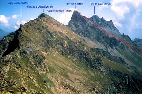
The Mount Paramont (3.301m) extension to the Northeast a long ridge that after the greatshoulder of Mount Pit (2.914m), reaches the Mollette Hill (2.774m), and from this the ridge dividing the Walloons d'en Haut and Tillac, to the North above the Forest of Derby, from that of Planaval/Fond in South bend gradually to the East and form in succession: Pointe of Crosatie and Hill, Bec Taillà and Pass, Tower of Tighet or du Tignet and Hill also called Torre Tonda Hill, Pass and two Tops of Faveroy, beyond which ends with the Colle del Monte Colombo and the namesake Mount (1.841m), large wooded-rocky rampart above the Central Valley of the River Dora Baltea. The Bec Taillà is the highest of this group of mini mountains, always poorly attended and most well known by hunters than by hikers or climbers. In fact, with the exception of the Hill of Crosatie (where it passes the Alta Via n° 2; moreover it runs the "Tor de Giants", the famous race that runs through the entire Valley of Aosta) and the nearby and easy to homonymous point, the other peaks are rarely crowded , even for the poor quality of the rock and access quite complicated. We must therefore get to Monte Colombo to find an easy walk with well marked trail. The Bec Taillà also is "hidden" from the pyramid most out of the Tower of Tighet, also giving the visual impression (wrong) to be lower than this. Beautiful views across the Valley of Aosta from Mount Blanc to the peaks of Mount Rosa; shots glances exceptional on Paramont and glaciers Rutor, Oriental side.
 |
Il Monte Paramont (3.301 m) prolunga verso Nordest una lunga cresta che, dopo lo spallone del Mont Pit (2.914 m), raggiunge il Colle delle Mollette (2.774 m); da questi la cresta divisoria i Valloni d'en Haut e Tillac, a Settentrione sopra la Foresta di Derby, da quello di Planaval/Fond a Mezzogiorno piega gradualmente più verso Est e forma in successione: Punta della Crosatie e Colle, Bec Taillà e Colle, Torre del Tighet o du Tignet e Colle detto anche Colle della Torre Tonda, Colle e due Punte di Faveroy, oltre le quali termina con il Colle del Monte Colombo ed il Monte omonimo (1.841 m), grande spalto roccioso-boschivo sopra la Valle Centrale del Fiume Dora Baltea. Il Bec Taillà risulta la Vetta più elevata di questo mini gruppo di montagne, sempre scarsamente frequentate e più conosciute dai cacciatori che non dagli escursionisti od alpinisti. Infatti, ad eccezione del Colle della Crosatie (dove passa l'Alta Via n° 2; si corre inoltre la "Tor de Géants", gara famosa che attraversa tutta la Valle di Aosta) e della vicina e facile omonima punta, le altre cime son raramente frequentate, anche per la cattiva qualità della roccia e gli accessi abbastanza complicati. Bisogna infatti arrivare al Monte Colombo per trovare una passeggiata facile con sentiero ben indicato. Il Bec Taillà inoltre viene "nascosto" dalla piramide più in evidenza della Torre del Tighet, dando anche l'impressione ottica (sbagliata) di essere più basso di questa. Belle viste su tutta la Valle di Aosta dal Monte Bianco fino alle cime del Rosa; colpi d'occhio eccezionali sul vicino Paramont e sui ghiacciai del Rutor, lato Orientale.
First Ascents
- First on the summit: Unknown.
- In winter: Unknown.
- South Face: Osvaldo Cardellina, Luigi Gadin and Giuseppe Lamazzi, (Oct 27th, 1985), in descent after the traverse from Torre Tonda-Tighet Tower.
Getting There
BY CAR:- From Torino, Milano, etc: Motorway A5. Exit at Aosta Ovest.
- From Switzerland: through the Grand Saint Bernard Tunnel or the namesake Pass.
- From France: through the Mont Blanc Tunnel or Petit Saint Bernard Pass: It is not necessary to take Motorway A5: you can drive on SS.26, in the direction of Leverogne.
- Aeroporto "Corrado Gex" Saint Christophe (Aosta).
 |
Road Itinerary
From the City of Aosta (583m) follow the SS.26 in the direction of Mont Blanc. Near the Village of Leverogne (780m) turn left on the Regional Road for Valgrisenche. Go past the Villages of Rochefort, La Ravoire, and Chamencon; then turn right for the Village of Planaval (1.557m), about 10 km from Leverogne. You can park here and continue on foot along the paved road in the direction of the Village of La Clusaz (1.631m).Dalla città di Aosta (583 m) si percorre la SS.26 per il Monte Bianco e, giunti nei pressi dell'abitato di Leverogne (780 m), si imbocca sulla sinistra la strada regionale per la Valgrisenche, dopo aver superato le Frazioni di Rochefort, La Ravoire, e percorso una decina di chilometri svoltare a destra verso la Frazione di Planaval (1.580 m). Da Planaval al Villaggio di La Clusaz (1.628 m).
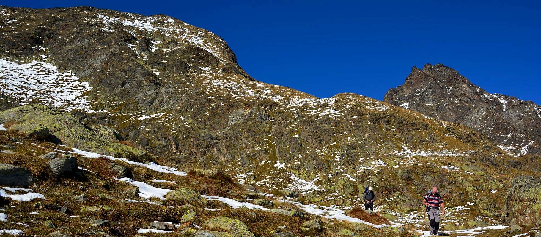
![Bec Tailla]() At the first bend in the shape of elbow immediately after the village started with the path n° 21/Alta Route n° 2 (signs), leaving on the right the road continues towards the Hamlet Baule(i)n (1.769m); proceeding with West-northwest direction with a long diagonal, followed by a series of narrow and small hairpin bends, get near the Torrent of Planaval at an altitude of about 2150 meters. Walk along its shore hydrographic left (North), leaving on the left the Alpage of Glacier (2.162m) and on the right path n° 20b which goes to the Torre Tonda Hill. Continue in parallel with the torrent and then move away temporarily from the same, when it meets to Torrent de l'Orfeuille. Immediately after crossing it twice before returning to skirt the Northern shore with West-northwest direction first and then definitely in the Southwest towards the Baracche di Fond (2.338m) under the lake of the same name (2.438m). Not achieve both, but, if the path changes direction (1h'30 around), abandon it and climb to the right (North-northwest) along the moraine between Bec Taillà (West) and the Tour du Tighet or Tignet (2.976m), reaching through a final stretch more steep, Taillà Pass (2.931m). From thysl turn left and drive along the Eastern Crest of Bec Taillà passing in succession a small wall (+I°/II°-, on the ridge) followed by two rounded hillocks. In the final part, which rises with lower slope and pseudo straight path, reach the Summit (3h'00/3h'30 from La Clusaz).
At the first bend in the shape of elbow immediately after the village started with the path n° 21/Alta Route n° 2 (signs), leaving on the right the road continues towards the Hamlet Baule(i)n (1.769m); proceeding with West-northwest direction with a long diagonal, followed by a series of narrow and small hairpin bends, get near the Torrent of Planaval at an altitude of about 2150 meters. Walk along its shore hydrographic left (North), leaving on the left the Alpage of Glacier (2.162m) and on the right path n° 20b which goes to the Torre Tonda Hill. Continue in parallel with the torrent and then move away temporarily from the same, when it meets to Torrent de l'Orfeuille. Immediately after crossing it twice before returning to skirt the Northern shore with West-northwest direction first and then definitely in the Southwest towards the Baracche di Fond (2.338m) under the lake of the same name (2.438m). Not achieve both, but, if the path changes direction (1h'30 around), abandon it and climb to the right (North-northwest) along the moraine between Bec Taillà (West) and the Tour du Tighet or Tignet (2.976m), reaching through a final stretch more steep, Taillà Pass (2.931m). From thysl turn left and drive along the Eastern Crest of Bec Taillà passing in succession a small wall (+I°/II°-, on the ridge) followed by two rounded hillocks. In the final part, which rises with lower slope and pseudo straight path, reach the Summit (3h'00/3h'30 from La Clusaz).
Route

DESCENT: From the same route. Do not be attracted to other solutions, all dangerous to the quality of the rock and the material pending.

DISCESA: Tramite la stessa via. Non lasciarsi attrarre da altre pericolose soluzioni, vista la cattiva qualità della roccia ed il numeroso materiale sospeso sulla medesima.
L'itinerario è classificato F/F+, con brevi passaggi di II°-.
Equipment for the Route
Normal hiking equipment.Da escursionismo.
Campings
Remember that free camping is forbidden (except for emergency reasons, over 2.500m, from darkness until dawn).Mountain Condition
- Meteo: you can find all the needed informations at the official site of the Valle d'Aosta Region:
- Valle d'Aosta Meteo
Webcam
- WEBCAM on Aosta Valley:
- Webcam
Books and Maps
BOOKS:- "Guida delle Alpi Occidentali" di Giovanni Bobba e Luigi Vaccarone C.A.I. Sezione di Torino Volume II (parte II) 25-05-1896.
- "Guida dei Monti d'Italia Alpi Graie Centrali" di Alessandro Giorgetta - Club Alpino Italiano-Touring Club Italiano, 1985 (in Italian).
- "Diari Alpinistici" di Osvaldo Cardellina e Indice Generale accompagnato da Schedario Relazioni Ascensioni 1964-2019 unpublished).
 |
 |
 |
MAPS:
- Kompass "Gran Paradiso Valle d'Aosta" Sentieri e Rifugi Carta turistica 1:50.000.
- Enrico Editore Ivrea-Aosta "Gruppo del Gran Paradiso" 1:50.000.
- L'Escursionista "La Thuile-Piccolo San Bernardo" Carta dei sentieri (n° 2) 1:25.000.
- L'Escursionista "Valgrisenche Val di Rhêmes" Carta dei sentieri (n° 3) 1:25.000.
- I.G.C. Istituto Geografico Centrale Torino "Il Parco Nazionale del Gran Paradiso" (3) 1:50.000.
- I.G.C. Istituto Geografico Centrale Torino "Valsavarenche Val di Rhêmes Valgrisenche P.N.G.P.", 1:25.000.
- Hapax "Les Sentiers Comunità Montana Valdigne-Mont Blanc", 1:50.000.
Important Information
- REGIONE AUTONOMA VALLE D'AOSTA the official site.
- FONDAZIONE MONTAGNA SICURA Villa Cameron, località Villard de la Palud n° 1 Courmayeur (AO) Tel: 39 0165 897602 - Fax: 39 0165 897647.
- SOCIETA' DELLE GUIDE DI VALGRISENCHE.
- A.I.NE.VA. (Associazione Interregionale Neve e Valanghe).
Useful Numbers
- Protezione Civile Valdostana località Aeroporto n° 7/A Saint Christophe (Ao) Tel. 0165-238222.
- Bollettino Meteo (weather info) Tel. 0165-44113.
- Unità Operativa di Soccorso Sanitario Tel. 118.
Acknowledgements
I am greatly indebted to my friend "Osva" for the detailed description of the route.