
-
 6494 Hits
-
 83.69% Score
-
 17 Votes
|
|
Mountain/Rock |
|---|---|
|
|
45.59610°N / 7.10258°E |
|
|
Mountaineering |
|
|
10610 ft / 3234 m |
|
|
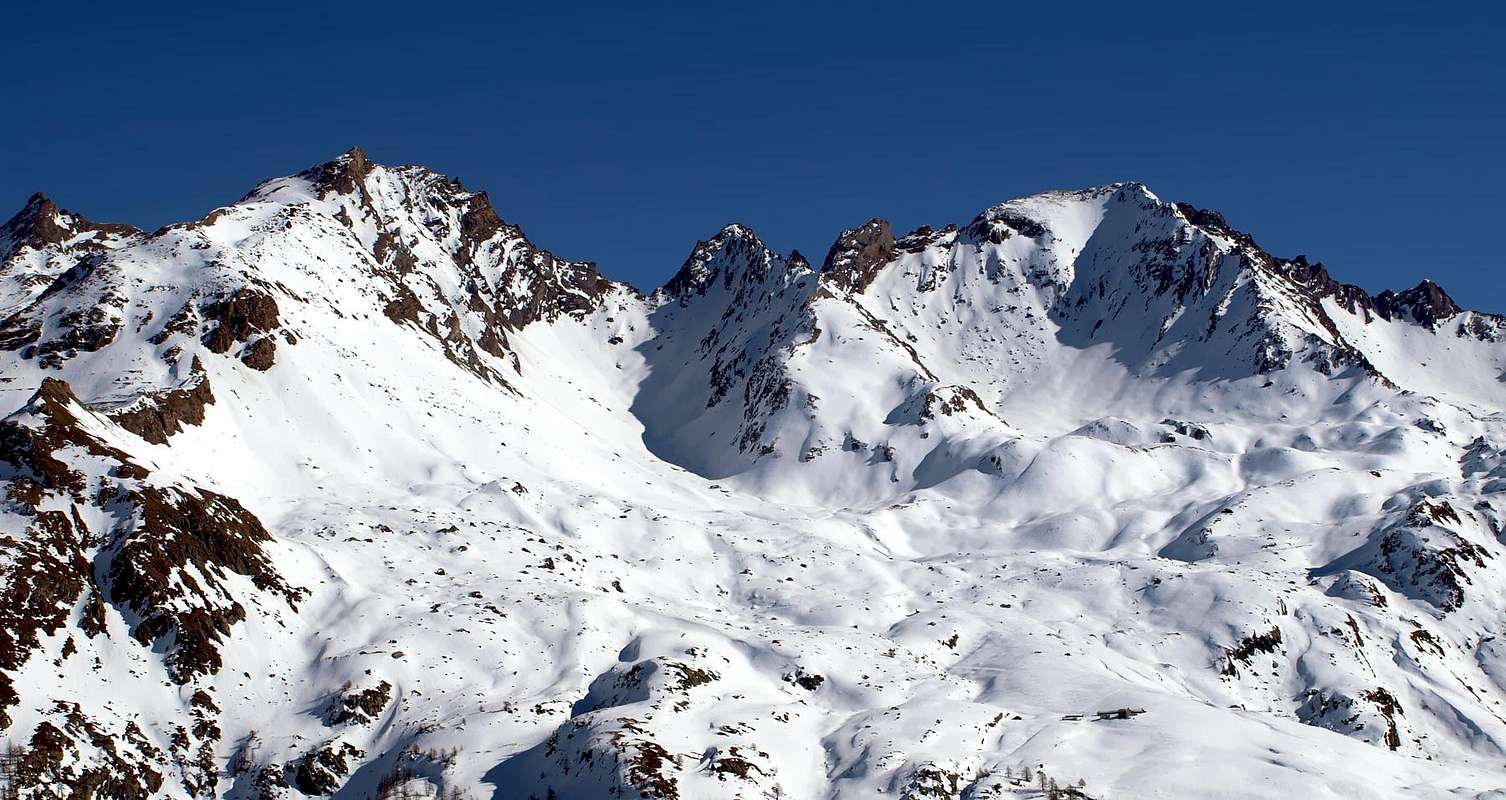
Overview
Big mountain, the highest on the watershed Valgrisenche-Valle di Rhêmes between Colle della Finestra and Colle di Tzaboc, it has a slightly squeezed pyramidal shape and has four ridges (and, of course, four walls) joining in an almost perfect cross.
Massiccia montagna, la più elevata nel tratto di cresta spartiacque Valgrisenche-Valle di Rhêmes tra il Colle della Finestra ed il Colle di Tzaboc; a forma di piramide leggermente depressa è formata da quattro creste che si intersecano a forma di croce quasi perfetta e da altrettante pareti.
First Ascents
- First on the summit: G. B. Bozzino and B. Ségor, (Aug 21th, 1909).
- In winter: Unknown.
- N-W Slope: G. B. Bozzino and B. Ségor, (Aug 21th, 1909), in descent.
- S Arête: G. B. Bozzino and B. Ségor, (Aug 21th, 1909).
- E Arête: E. L. Rossi di Montelera and E. Lucianaz, (Jul 13-14th, 1975).
- W Arête: Osvaldo Cardellina and Giuseppe Lamazzi, (Sep 15th, 1996).
Getting There
BY CAR:- From Torino, Milano, etc: Motorway A5. Exit at Aosta Ovest.
- From Switzerland: through the Grand Saint Bernard Tunnel or the namesake Pass.
- From France: through the Mont Blanc Tunnel or Petit Saint Bernard Pass: It is not necessary to take Motorway A5: you can drive on SS.26, in the direction of Leverogne.
- Aeroporto "Corrado Gex" Saint Christophe (Aosta).
Itinerary
From the City of Aosta (583m) follow SS.26 toward Mont Blanc. Once close to the Village of Leverogne (780m), turn left on the Regional Route for Valgrisenche. Pass many small Villages, including Rochefort, La Ravoire, Chamencon, La Bethaz, and the Town of Valgrisenche. Turn right for the Village of Bonne (1.810m) located near the huge dam that forms the Beauregard Reservoir. Past the small Village of Menthieu (1.842m), continue for approximately 5 km along the paved road, which follows the shore and leads to the old Pasture of Surier (1.758m), near the Village of Usellières (1.758m).Dalla Città di Aosta (583 m) si percorre la SS.26 per il Monte Bianco e, giunti nei pressi dell'abitato di Leverogne (780 m), si imbocca sulla sinistra la Strada Regionale per la Valgrisenche, dopo aver superato le Frazioni di: Rochefort, La Ravoire, Chamencon, La Bethaz ecc. Dopo aver superato il Capoluogo di Valgrisenche, si continua sulla destra per la Frazione di Bonne (1.810 m), situata proprio di fianco all'enorme sbarramento artificiale che racchiude il Lago di Beauregard. Dopo aver superato il piccolo Villaggio di Menthieu (1.842 m), si prosegue per circa 5 km lungo la strada asfaltata che costeggia il lago e che porta al vecchio Alpeggio di Surier (1.758 m), vicino al Villaggio di Usellières (1.758 m).
Route
Starting from Usellières (1.758m), along the road on the western border of Beauregard Lake (passing through Bonne), or from the hairpin at Mondanges (1.690m) (the road on the eastern side is closed due to risk of falling stones) get the close Plonta (2.303m) or Pra Londzet (2.300m) Pastures, From the dirt road before Pra Londzet, near a stream, climb along a small valley and, on tracks, get the base of the WSW ridge near the "Sfinge" (Sphinx), a pinnacle at its beginning. Turn around it to the South along a dihedral/channel (II°) then follow the edge (I° e II°) up to a shoulder, down some 10 meters (II°) and when on a step (2 fitted boulders), down to the right then to the left to a notch (III°), up for some 10 meters and, after an exposed cross to the right, climb to the ridge, on bad rock, along a dihedral (II°, exposesd) Now on easy rocks (I° e II°) up to the summit (4h'00/4h'45).Descent: For NW Slope.
Raggiungere i vicini Alpeggi di Plonta (2.303 m) o di Pra Londzet (2.300 m) partendo da Usellières (1.758 m), raggiungibile in carrozzabile lungo il tratto ovest del Lago Artificiale di Beauregard, transitando da Bonne; oppure dal tornante in località Mondanges (1.690 m), poiché la strada del lato est del lago è chiusa per caduta massi. Dalla strada poderale prima di Pra Londzet, nei pressi di un torrentello, risalire un piccolo vallone e per tracce di sentiero raggiungere la base della cresta Ovest Sud-Ovest presso la "Sfinge", pinnacolo posto all'inizio della medesima. Aggirarlo a sud per un diedro-canale (II°) proseguendo poi sul filo (I° e II°) fino ad una spalla; scendere una decina di metri (II°) e, raggiunto un salto con due massi incastrati, scendere prima a destra e poi a sinistra fino alla sottostante forcella (III°). Risalire un decina di metri e, dopo una traversata esposta a destra, ritornare in cresta lungo un diedro-canale su roccia friabile (II°, molto esposto); da qui per tratti di I° e II° si raggiunge la vetta (4h'00/4h'45). Discesa: Lungo il versante NW.
Difficulty
This route can be considered AD-.L'itinerario è classificato AD-.
Climbing Shots
 |
 |
 |
Equipment
Alpinistic gear, rope and helmet.Campings
Remember that free camping is forbidden (except for emergency reasons, over 2.500m, from darkness until dawn).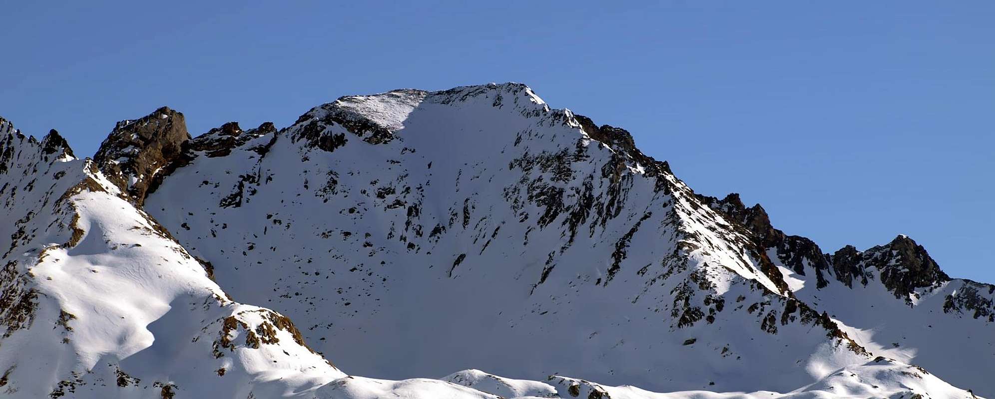
Mountain Conditions
- You can get meteo information at the official site of the Regione Valle d'Aosta:
- Valle d'Aosta Meteo
Webcam
- WEBCAM on Aosta Valley:
- Webcam
Books and Maps
BOOKS:- "Guida delle Alpi Occidentali", di Giovanni Bobba e Luigi Vaccarone C.A.I. Sezione di Torino Volume II (parte II), 25 Maggio 1896.
- "Guida dei Monti d'Italia–Alpi Graie Centrali" di Alessandro Giorgetta - Club Alpino Italiano/Touring Club Italiano, 1985 (in Italian).
- "Diari Alpinistici" di Osvaldo Cardellina e Indice Generale accompagnato da Schedario Relazioni Ascensioni 1964-2019 (unpublished).
 |
 |
MAPS:
- Kompass "Gran Paradiso Valle d'Aosta Sentieri e Rifugi", Carta turistica 1:50.000.
- L'Escursionista "Valgrisenche Val di Rhêmes", Carta dei sentieri (n° 3) 1:25.000.
- Enrico Editore Ivrea-Aosta "Gruppo del Gran Paradiso" 1:50.000.
- I.G.C. Istituto Geografico Centrale Torino "Il Parco Nazionale del Gran Paradiso", 1:50.000.
Important Information
- REGIONE AUTONOMA VALLE D'AOSTA the official site.
- FONDAZIONE MONTAGNA SICURA Villa Cameron, località Villard de la Palud n° 1 Courmayeur (AO) Tel: 39 0165 897602 - Fax: 39 0165 897647.
- SOCIETA' DELLE GUIDE DI VALGRISENCHE.
- A.I.NE.VA. (Associazione Interregionale Neve e Valanghe).
Useful numbers
- Protezione Civile Valdostana località Aeroporto n° 7/A Saint Christophe (Ao) Tel. 0165-238222.
- Bollettino Meteo (weather info) Tel. 0165-44113.
- Unità Operativa di Soccorso Sanitario Tel. 118.
Acknowledgements
I am greatly indebted to my friend "Osva" for the detailed description of the route. In addition I want to thank Gabriele Roth for the translation of the text from italian.