

-
 8631 Hits
-
 88.61% Score
-
 27 Votes
|
|
Mountain/Rock |
|---|---|
|
|
45.58340°N / 6.98040°E |
|
|
10754 ft / 3278 m |
|
|
Overview
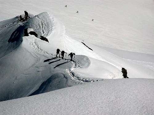
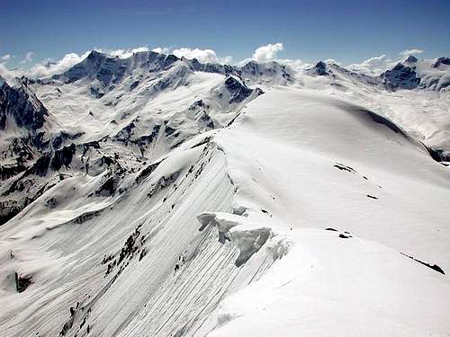
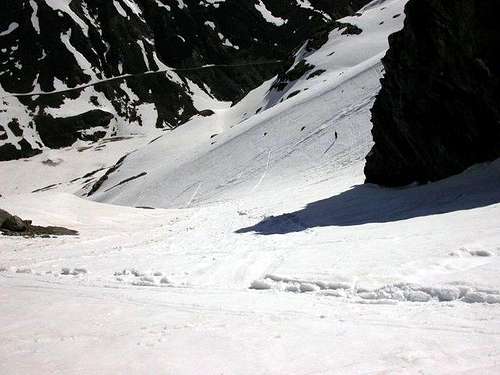
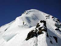
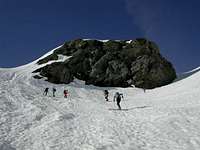
Mont Ormelune (also known as Archèboc, should be french name or a Frenchification), is not properly a single edge, unless it is seen from NW, but a long chain of three different summits: East (3.252m), Central (3.231m) and, the highest, West summit, (3.278m). The Ormelune is a magic mountain, with huge slopes, sometimes sweet, sometimes very hard, where every curve, descending, is pure emotion, expecially when skiing on Ormelune Glacier.This ski-randonnée has an alpinistic final, with an iced ridge. In very few years snow helps to cover hard ice, for an easiest ascent to the top. For last 50 meters, to get to the top, crampons and ice-axe are a must. Due to NE exposion, snow remains acceptable until half june. Perfect assested snow is required, expecially for the first steep gully, accessing to higher plateau.This ski-mountaineering hike is recommended from half May to half June, when road to Bonne-Surier-Usellieres is opened. See further sections for more details.
 |
 |
Il Monte Ormelune (noto anche come Punta dell' Archèboc, che dovrebbe essere una variante di francesizzazione), non è propriamente un singolo spigolo di crestone, a meno che non sia visto da Nordovest, ma in realtà consiste in una lunga catena di tre diversi vertici: Est (3.252 m), Centrale (3.231 m) e, la cima più alta od Ovest, (3.278 m). L'Ormelune è una montagna magica, con pendenze enormi, a volte dolci, a volte molto dure, dove ogni curva, discendente, si tranmuta in pura emozione, soprattutto quando si scia sul Ghiacciaio di Ormelune. Questo sci-randonnée ha un finale alpinistico, con una cresta ghiacciata. Da pochissimi anni la neve aiuta a coprire il ghiaccio duro, per una salita più facile verso l'alto. Per gli ultimi 50 metri, per arrivare in cima, i ramponi e la piccozza sono indispensabili.A causa dell'esposizione Nordest, la neve rimane accettabile fino alla metà di giugno. È necessaria neve perfettamente assestata, soprattutto per il primo ripido canalone, che porta all'altopiano superiore. Questa escursione di scialpinismo è consigliata da metà maggio a metà giugno, quando viene aperta la strada per Bonne-Surier-Usellieres. Vedi ulteriori sezioni per maggiori dettagli.
First Ascents
- First on the Summit SE Ridge: R. C. Nichols, and J. V. Favret, (Jul 29th, 1865). (E Summit).
- SE Ridge : Giovanni Bobba and Casimiro Thérisod, (Aug 09th, 1890). (Central Summit).
- SW Side: Cap. Albert dello S.M. Sardo, (1832). (W Summit).
- In winter: Unknown.
 |
 |
 |
 |
Getting There
BY CAR:
- From Torino, Milano, etc: Motorway A5. Exit at Aosta Ovest. Drive on SS.26 toward Mont Blanc as far as Leverogne (780m).
- From Switzerland: through the Grand Saint Bernard Tunnel or the namesake Pass. Drive to Aosta, then follow the direction for Courmayeur on SS.26 as previously, reaching Leverogne.
- From France: through Mont Blanc Tunnel or Petit Saint Bernard Pass. It is not necessary to take Motorway A5: you can drive on SS.26, in the direction of Aosta as far as Leverogne. Once close to the Village of Leverogne (780m), turn left if you come from Aosta or turn right coming from Mont Blanc, following along the Regional Route for Valgrisenche. Pass many small Villages, including Rochefort, La Ravoire, Chamencon, La Bethaz, and Valgrisenche (1.664m), the main center of the namesake valley. Turn right for the Village of Bonne (1.810m) located near the western summit edge of the huge dam that forms the Beauregard Reservoir, practically empty for technical reasons. Past the small Village of Menthieu (1.842m), continue for approximately 5 km along the paved road, which follows parallel to the western shore of the lake, then go down to a junction (where to leave the car), turn right and head towards the Alpeggio Gran Alpe (1.988m).
BY PLANE:
- Aeroporto "Corrado Gex" Saint Christophe (Aosta).
 |
 |
Route
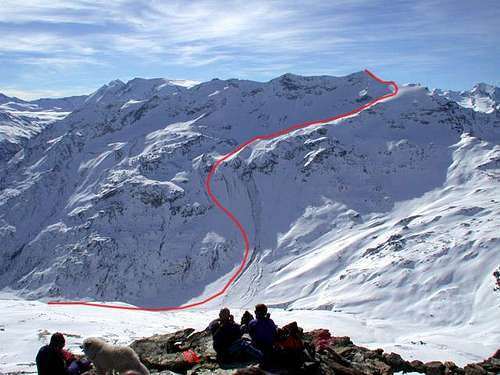
For the Northeast Slope from the Glacier de l'Ormelune: from the Village of Surier (1.785m) drive West-northwest along the n° 13/14 paths the HRG (Alta Via Glaciale or High Glacial Route) entering into the Vallon de Saint Grat and passing through Grand Alpe (1.988m), climb in the direction of the Col du Mont (2.639m) until you reach the altitude of about 2.100 meters before the Alpe Revèraz desot (lower, 2.153m). Won or waded the Torrent de Grand'Alpe, climb with a small path formed by many zig zag through a grassy slope that gradually turns into debris until you reach the moraine of the Glacier de l'Ormelune. Go up towards the Punta Centrale or Pointes de l'Ormelune (Central Summit, 3.231m), the lowest of the three existing along the Southeast / Northwest axis, with an obligatory itinerary and reaching the base of the glacier. With a progressively West-northwest route towards the highest summit or Pointe de l 'Archeboc (3.278m), we head towards the North Ridge, which comes from le Rocher Brune (2.729m), reaching it not far from the summit snowy dome with which ends. (path that requires good snow conditions, 5h'00/6h'00 hours from Surier Village).
Per il Versante Nordest dal Glacier de l'Ormelune: dal Villaggio di Surier (1.785 m) percorrere verso Ovest-nordovest con i sentieri n° 13/14 la HRG (Alta Via Glaciale) entrando nel Vallon de Saint Grat e, passando per Grand Alpe (1.988 m), salire in direzione del Col du Mont (2.639 m) fino a raggiungere l'altitudine di metri 2.100 circa prima dell'Alpe Revèraz desot (2.153 m). Superato guadandolo il Torrent de Grand'Alpe, salire con un piccolo sentiero formato da molti zig zag attraverso un pendio erboso che gradualmente si trasforma in detriti fino a raggiungere la morena del Glacier de l'Ormelune. Salire in direzione della Punta Centrale o Pointes de l'Ormelune (3.231 m), la più bassa delle tre esistenti lungo l'asse Sudest/Nordovest, con itinerario non obbligato e raggiungendo la base del ghiacciaio. Con percorso progressivamente verso Ovest-nordovest in direzione della sommità più elevata o Pointe de l' Archeboc (3.278 m) ci si indirizza verso la Cresta Nord, che proviene da la Rocher Brune (2.729 m), raggiungendola non lontano dalla cupola nevosa sommitale con la quale si conclude. (percorso che richiede buone condizioni di innevamento; ore 5h'00/6h'00 da Surier).
When To Climb
From *beginning of May, until half June.*It depends on when road Bonne-Surier is opened.
Da * all'inizio di maggio, fino a metà giugno. * Dipende dal momento in cui viene aperta la strada Bonne-Surier.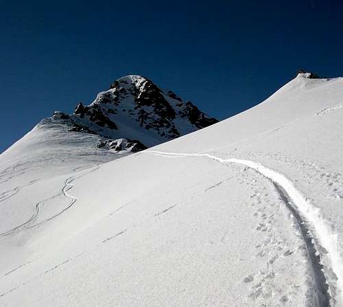 |
Difficulties
EE/F for Excursions to Summit; BSA or Good Difficulty for Ski-Mountaineering.EE/F per l'Escursionismo fino alla Vetta; BSA per Sciatori di Buon Livello per lo Sci-Alpinismo.
Equipment
Standard for Excursions or with snowshoes also by ski-mountaineering.Standard da Escursionismo oppure con racchette da neve o da sci-alpinismo.
 |
 |
 |
 |
 |
Campings
Remember that free camping is forbidden (except for emergency reasons, over 2.500m, from darkness until dawn).
Mountain Conditions
- You can get meteo information at the official site of the Regione Valle d'Aosta:
- Valle d'Aosta Meteo
Webcam
- WEBCAM on Aosta Valley:
- Webcam
Books and Maps
BOOKS:
- "Guida delle Alpi Occidentali", di Giovanni Bobba e Luigi Vaccarone C.A.I. Sezione di Torino Volume II (parte II), 25 Maggio 1896.
- "Il Parco Nazionale del Gran Paradiso (Valli Soana-Orco-Rhêmes-Valgrisenche)" di Giulio Berutto, I.G.C. Torino 1979.
- "Guida dei Monti d'Italia – Alpi Graie Centrali" di Alessandro Giorgetta - Club Alpino Italiano/Touring Club Italiano, 1985 (in Italian).
- "Diari Alpinistici" di Osvaldo Cardellina e Indice Generale accompagnato da Schedario Relazioni Ascensioni 1964-2019 (inediti).
- "Guida della Regione Autonoma Valle d'Aosta" di Mario Aldrovandi, Ed. S.P.E. di Carlo Fanton, Torino 31 Dicembre 1964.
 |
 |
 |
 |
 |
MAPS:
- Kompass "Gran Paradiso Valle d'Aosta Sentieri e Rifugi", Carta turistica 1:50.000.
- Enrico Editore Ivrea-Aosta "Gruppo del Gran Paradiso" 1:50.000.
- I.G.C. Istituto Geografico Centrale "Il Parco Nazionale del Gran Paradiso", 1:50.000.
- I.G.C. Istituto Geografico Centrale Torino "Valsavarenche Val di Rhemes Valgrisenche Parco Nazionale del Gran Paradiso", (carta n° 102), 1:25.000.
 |
 |
 |
 |
Important Information
- REGIONE AUTONOMA VALLE D'AOSTA the official site.
- FONDAZIONE MONTAGNA SICURA Villa Cameron, località Villard de la Palud n° 1 Courmayeur (AO) Tel: 39 0165 897602 - Fax: 39 0165 897647.
- SOCIETA' DELLE GUIDE DI VALGRISENCHE
- A.I.NE.VA. (Associazione Interregionale Neve e Valanghe).
Useful Numbers
- Protezione Civile Valdostana località Aeroporto n° 7/A Saint Christophe (Ao) Tel. 0165-238222.
- Bollettino Meteo (weather info) Tel. 0165-44113.
- Unità Operativa di Soccorso Sanitario Tel. 118.
Acknowledgements
I am greatly indebted to my friend "Osva" for the detailed description of the route, all texts and translation.