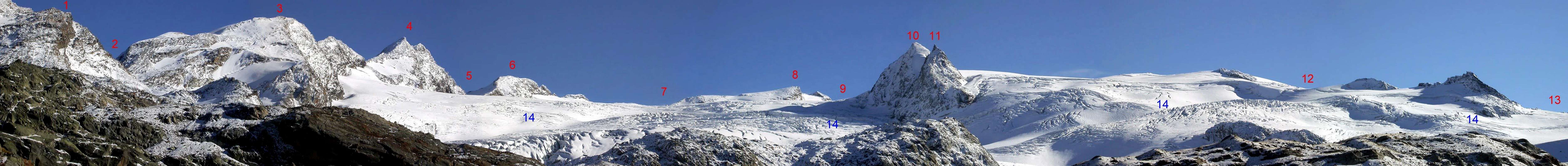
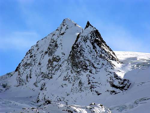
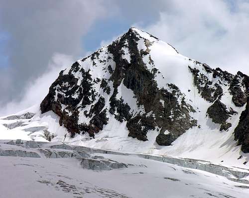
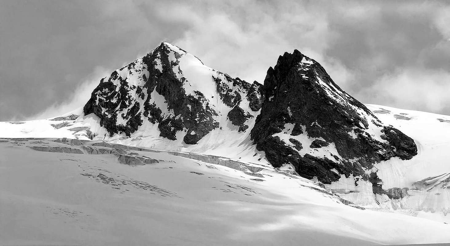
Just N of the Pointe Avernet (3.307m), on the border between France (Vanoise) and Italy (La Thuile) two summits rise up: the Vedette del Rutor. They form a big prow breaking the huge Rutor Glacier in two parts: the Upper and the Lower Basins. Though not much popular, they give excellent points of view on the Grande Assaly and the Ridge Paramont/Rutor.
Subito a nord de la Pointe Avernet (3.307 m), sul confine italo-francese (LaThuile/Vanoise) sorgono le due Vedette del Rutor; formano una grande prua che spezza in due l'enorme Glacier du Rutor, tra i Bacini Inferiore e Superiore. Non molto frequentate, offrono un'eccellente panorama sulla Grande Assaly e sulla Costiera Paramont/Rutor.
First Ascents
Vedetta Sud:
First on the summit: G. Bobba, L. Cibrario, L. Vaccarone and G. Noro, (Aug 17th, 1890).
In winter: Unknown.
S-E Arête: G. Bobba, L. Cibrario, L. Vaccarone and G. Noro, (Aug 17th, 1890).
Vedetta Nord:
First on the summit: G. Studer, J. J. Weilenmann and G. B. Frassy, (Aug 10th, 1858).
In winter: Unknown.
N Slope and N Arête: G. B. Origoni, G. Origoni and Abbé G. Bonin, (Aug 09th, 1892).
Getting There
BY CAR:
From the Morgex exit of Motorway A5(921m), continue for about 3 km on SS.26 Towards Pré Saint Didier (1.017m). SS.26 becomes the main street of the small city and then continues toward Colle del Piccolo San Bernardo (2.188m). After several hairpins, and past the Villages of Elevaz (1.302m) and la Balme (1.309m) reach the famous ski resort of La Thuile (1.441m). Turn left on the bridge that crosses Dora di La Thuile in the direction of the Village of La Joux. After about 2 km from the bridge, having past a large square, cross another bridge on the Dora to the right. (From this point on, the road, although paved, is quite narrow. Proceed with caution.) After 1 km get to La Joux (1.607m) and park in one of the two parking lots, which are large but sometimes fill up in August. For this reason, access past the second bridge is limited at certain times. Be there before 9 AM to avoid problems, or take the shuttle bus to cover the last stretch.
IN AUTO:
Dall'uscita dell'Autostrada A5 nel Comune di Morgex (921 m) proseguire per circa 3 km lungo la SS.26 verso il Paese di Pré Saint Didier (1.017 m), addentrarsi nella via centrale del paese e proseguire sempre lungo la Strada Statale n°26 che porta al Colle del Piccolo San Bernardo (2.188 m). Dopo numerosi tornanti e, superate le Frazioni di Elevaz (1.302 m) e la Balme (1309 m), si giunge alla famosa località sciistica di La Thuile (1441 m); svoltare a destra sul ponte che attraversa la Dora di La Thuile e dirigersi verso la Frazione di La Joux (1.607 m). Dopo circa 2 km e, superato un ampio piazzale, riattraversare sempre sulla destra un altro ponte sulla Dora (attenzione da questo punto la strada, seppur asfaltata, è molto stretta, procedere con cautela) e dopo circa 1 km. si giunge a La Joux (1.607 m). Qui posteggiare l'auto in uno dei due ampi parcheggi a volte insufficienti nel mese di agosto. Per questo motivo, relativamente al tratto dopo il secondo ponte, c'è una limitazione oraria all'accesso dei mezzi privati, che comunque non tocca chi arriva prima delle 9. In alternativa esiste comunque una navetta bus.
BY PLANE:
Aeroporto "Corrado Gex"; Saint Christophe (Aosta).
Route
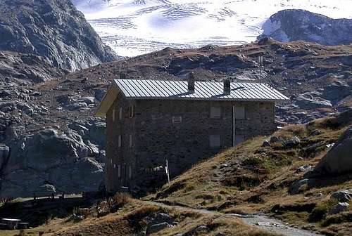
First day: the ascent for Rifugio Albert Deffeyes starts in front of "Bar Delle Cascate" on trail n° 3. Pass a wooden bridge on the left and after about 15 minutes you'll come to the first of the three spectacular Rutor Falls. Continue along the trail and leave Alpeggio di Parchet (1.772m) to your right. The trail continues up large steps and in a bit less than one hour passes by the second waterfall, which is not visible from the trail, but is marked by a sign. After another 15 minutes you'll reach the sign for the the third waterfall. Continue on the steep trail for another 20 minutes to a fork. Take the well-marked left branch that leads to the hut. (The right branch, numbered 8, leads to the beautiful Lakes of Bella Comba.) Climb to the small Col (2.130m) and then descend bending slightly to the right until Lago Glacier (2.143m). Cross the small wooden bridge over the lake outlet and, leaving Alpeggio Glacier to your right, climb steeply along wide hairpins to the plateau where Rifugio Albert Deffeyes is located at 2.494m This is a good place to spend the night (2h'45/3h'00 from La Joux).
Primo giorno: iniziare la salita verso il Rifugio Albert Deffeyes sul sentiero davanti al "Bar delle Cascate" contrassegnato con il n° 3, dopo aver oltrepassato un ponte in legno sulla sinistra e dopo circa 15' si incontra la prima del tre spettacolari Cascate del Rutor; proseguire lungo il sentiero e oltrepassare (sulla destra) l'Alpeggio di Parchet posto sulla destra (1.772 m). Continuare sempre lungo il sentiero che ora si inerpica a gradoni e dopo circa 55' si oltrepassa la seconda cascata (segnalata da un cartello e non visibile dal sentiero principale). Dopo circa altri 15' si incontra il cartello della terza cascata. Continuare sul ripido sentiero per altri 20'. Qui il sentiero si divide: prendere quello sulla sinistra ben segnalato che conduce al rifugio (quello di destra recante il n°8 porta ai magnifici Laghi di Bella Comba). Risalire sino al Colletto (2.130 m) per poi scendere leggermente sulla destra e proseguire fino al Lago Glacier (2.143 m); oltrepassare il ponticello in legno che sovrasta l'emissario del lago e, lasciando sulla destra l'omonimo alpeggio, riprendere a salire decisamente lungo ampi tornanti fino a raggiungere l'altipiano, dove è sito il Rifugio Albert Deffeyes (2.494 m), ove conviene pernottare (2h'45/3h'00 da La Joux).
Second Day: descend for about 50m the trail for the inlet stream of Lago Azzurro. Cross the small wooden bridge and keep the right trail that leads to the Upper Rutor Lakes (2.539m). After about 10 minutes the trail forks. Keep left and reach shorlty after a small lake known by the names of "Dans la Roche" or "Lac Sans Nom" (2.602m). Continue up to a small col at approximately 2.680m and on to the left moraine of the huge Rutor Glacier. (Here at 2.790m you'll find fixed ropes that have been recently placed after the moraine slid on the glacier. This is perhaps the most difficult spot of the entire ascent.) Past this point, leave on your left the small valley that leads to Colle di Planaval (3.016m). Go on ascending up to the left branch of the glacier, just above the Flambeau (3.315m). Follow up to near the Colle di Chatêau Blanc then cross toward W the higher plain of the Rutor Glacier (warning to the many crevasses) getting the Colle delle Vedette (3.256m). Along a snow slope and the crushed rocks of the SSE ridge, in less than 80 meters you get the S Summit (the highest one)(5h'00). Descent along the same route.
Secondo giorno: ridiscendere per circa 50 metri il sentiero che porta all'immissario del Lago Azzurro; attraversare il ponticello in legno e portarsi sul sentiero di destra che adduce ai Laghi Superiori del Rutor (2.539 m). Dopo circa 10' il sentiero si divide, continuare su quello si sinistra. Poco dopo si costeggerà un laghetto conosciuto come Dans la Roche o "Lac Sans Nom" (2.602 m). Salire sino al piccolo colle posto a circa (2.680 m); continuare sul sentiero fino a raggiungere la morena sinistra dell'enorme Ghiacciaio del Rutor (attenzione: qui a quota 2.790 m. circa si incontra un passaggio da superare con corde fisse a causa del recente franamento della morena sul ghiacciaio, forse il punto più difficile dell'intera salita). Oltrepassato questo punto, si lascia sulla sinistra il valloncello che porta al Colle di Planaval (3.016 m). Proseguire la salita fino a raggiungere la branca di sinistra del ghiacciaio posta subito sotto il Flambeau (3.315 m). Continuare la salita e, giunti nei pressi del Colle di Chatêau Blanc, attraversare verso W il pianoro superiore del Ghiacciaio del Rutor (attenzione la zona è molto crepacciata) arrivando al Colle delle Vedette (3.256 m). Per un pendio nevoso e per la cresta S-SE di rocce frantumate, in meno do 80 metri, si raggiunge la Vedetta S, la più elevata (5h'00). Discesa per la stessa via di salita.
Difficulty
The route is considered by F or F+ depending on mountain conditions.
L'itinerario è considerato da F a F+, dipende dalle condizioni della montagna.
Equipment
Mountaineering equipment including rope, ice axe, and crampons.
Parents refers to a larger category under which an object falls. For example, theAconcagua mountain page has the 'Aconcagua Group' and the 'Seven Summits' asparents and is a parent itself to many routes, photos, and Trip Reports.

 9115 Hits
 89.77% Score
 30 Votes