
-
 6048 Hits
-
 86.37% Score
-
 22 Votes
|
|
Mountain/Rock |
|---|---|
|
|
45.65140°N / 7.02129°E |
|
|
Mountaineering |
|
|
10876 ft / 3315 m |
|
|
Overview
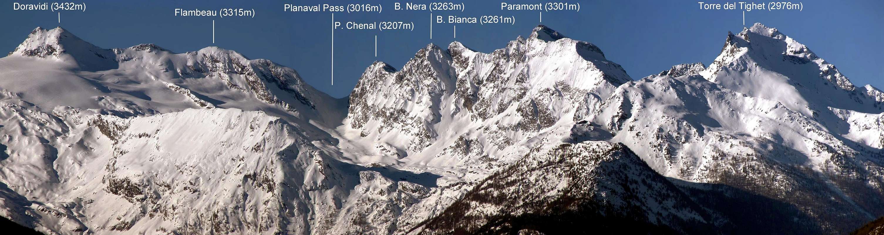
Immediately to north of the Mountain "Doravidi" (3.432m) the "Flambeau" (3.315m), between the Valgrisenche Valley and the La Thuile Valley is a not very busy mountain, offers however a' excellent panorama on the Large Assaly and on the Coastal Paramont/Rutor.
Subito a nord del Monte Doravidi (3.432 m) il Flambeau (3.315 m), tra la Valgrisenche e La Valle di La Thuile è una montagna non molto conosciuta, offre però un'eccellente panorama sulla Grande Assaly e sulla Costiera Paramont/Rutor.
![]()
First Ascents
- First on the summit S Arête: Abbè Chanoux and L. Vaccarone, (1879).
- N Slope: Abbè Chanoux and L. Vaccarone, (1879), in descent.
- In winter: Unknown.
Getting There
BY CAR:- From the Morgex exit of Motorway A5 (921m), continue for about 3 km on Strada Statale n°26 Towards Pré Saint Didier (1.017m). SS.26 becomes the main street of the small city and then continues toward Colle del Piccolo San Bernardo (2.188m). After several hairpins, and past the Villages of Elevaz (1.302m) and la Balme (1.309m) reach the famous ski resort of La Thuile (1.441m). Turn left on the bridge that crosses Dora di La Thuile in the direction of the Village of La Joux. After about 2 km from the bridge, having past a large square, cross another bridge on the Dora to the right. (From this point on, the road, although paved, is quite narrow. Proceed with caution.) After 1 km get to La Joux (1.607m) and park in one of the two parking lots, which are large but sometimes fill up in August. For this reason, access past the second bridge is limited at certain times. Be there before 9 AM to avoid problems, or take the shuttle bus to cover the last stretch.
- Dall'uscita dell'Autostrada A5 nel Comune di Morgex (921 m) proseguire per circa 3 km lungo la Strada Statale n°26 verso il Paese di Pré Saint Didier (1.017 m), addentrarsi nella via centrale del paese e proseguire sempre lungo la Strada Statale n° 26 che porta al Colle del Piccolo San Bernardo (2.188 m). Dopo numerosi tornanti e, superate le Frazioni di Elevaz (1.302 m) e la Balme (1.309 m), si giunge alla famosa località sciistica di La Thuile (1.441 m); svoltare a destra sul ponte che attraversa la Dora di La Thuile e dirigersi verso la Frazione di La Joux (1.607 m). Dopo circa 2 km e, superato un ampio piazzale, riattraversare sempre sulla destra un altro ponte sulla Dora (attenzione da questo punto la strada, seppur asfaltata, è molto stretta, procedere con cautela) e dopo circa 1 km. si giunge a La Joux (1.607 m). Qui posteggiare l'auto in uno dei due ampi parcheggi a volte insufficienti nel mese di agosto. Per questo motivo, relativamente al tratto dopo il secondo ponte, c'è una limitazione oraria all'accesso dei mezzi privati, che comunque non tocca chi arriva prima delle 9. In alternativa esiste comunque una navetta bus.
- Aeroporto "Corrado Gex" Saint Christophe (Aosta).
Route
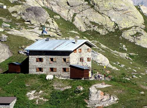
First day The ascent for Rifugio A. Deffeyes starts in front of "Bar Delle Cascate" on trail n° 3. Pass a wooden bridge on the left and after about 15 minutes you'll come to the first of the three spectacular Rutor Falls. Continue along the trail and leave Alpeggio di Parchet (1.772m) to your right. The trail continues up large steps and in a bit less than one hour passes by the second waterfall, which is not visible from the trail, but is marked by a sign. After another 15 minutes you'll reach the sign for the the third waterfall. Continue on the steep trail for another 20 minutes to a fork. Take the well-marked left branch that leads to the hut. (The right branch, numbered 8, leads to the beautiful Lakes of Bella Comba.) Climb to the Small Pass (2.130m) and then descend bending slightly to the right until Lago Glacier (2.143m). Cross the small wooden bridge over the lake outlet and, leaving Alpeggio Glacier to your right, climb steeply along wide hairpins to the plateau where Rifugio A. Deffeyes is located at 2.494m This is a good place to spend the night (2h'45/3h'00 from La Joux).1° giorno Iniziare la salita verso il Rifugio A. Deffeyes sul sentiero davanti al "Bar delle Cascate" contrassegnato con il n° 3, dopo aver oltrepassato un ponte in legno sulla sinistra e dopo circa 0h'15 si incontra la prima del tre spettacolari Cascate del Rutor, proseguire lungo il sentiero e oltrepassare (sulla destra) l'Alpeggio di Parchet posto sulla destra (1.772 m). Continuare sempre lungo il sentiero che ora si inerpica a gradoni e dopo circa 0h'55 si oltrepassa la seconda cascata (segnalata da un cartello e non visibile dal sentiero principale), dopo circa altri 0h'15 si incontra il cartello della terza cascata; continuare sul ripido sentiero per altri 0h'20; qui il sentiero si divide, prendere quello sulla sinistra ben segnalato che conduce al rifugio (quello di destra recante il n° 8 porta ai magnifici Laghi di Bella Comba). Risalire sino al Colletto (2.130 m) per poi scendere leggermente sulla destra e proseguire fino al Lago Glacier (2.143 m); oltrepassare il ponticello in legno che sovrasta l'emissario del lago e, lasciando sulla destra l'omonimo alpeggio, riprendere a salire decisamente lungo ampi tornanti fino a raggiungere l'altipiano dove è sito il Rifugio A. Deffeyes (2.494 m): qui conviene pernottare (2h'45/3h'00 da La Joux).
Second Day Descend for about 50 meters the trail for the inlet stream of Lago Azzurro. Cross the small wooden bridge and keep the right trail that leads to the Upper Rutor Lakes (2.539m). After about 10 minutes the trail forks. Keep left and reach shorlty after a small lake known by the names of "Dans la Roche" or "Lac Sans Nom" (2.602m). Continue up to a small col at approximately 2.680m and on to the left moraine of the huge Rutor Glacier. (Here at 2.790m you'll find fixed ropes that have been recently placed after the moraine slid on the glacier. Descent along the same route. To continue the long ascent the small valloncello that carries to the Hill of Planaval (3.016m), to a hundred meters from the hill to turn verse south and to go back lieutenant himself to the center the small glacier of the Flambeau, therefore for a detrital slope and often snow-covered it it is reached the top (2h'30/3h'00) from the Shelter Deffeyes. Coming down is along the same route.
2° giorno Ridiscendere per circa 50 metri il sentiero che porta all'immissario del Lago Azzurro; attraversare il ponticello in legno e portarsi sul sentiero di destra che adduce ai Laghi Superiori del Rutor (2.539 m). Dopo circa 0h'10 il sentiero si divide, continuare su quello si sinistra. Poco dopo si costeggerà un laghetto conosciuto come Dans la Roche o "Lac Sans Nom" (2.602 m). Salire sino al piccolo colle posto a circa (2.680 m); continuare sul sentiero fino a raggiungere la morena sinistra dell'enorme Ghiacciaio del Rutor (attenzione: qui a quota 2.790 m circa si incontra un passaggio da superare con corde fisse a causa del recente franamento della morena sul ghiacciaio. Continuare la salita lungo il piccolo vallone che porta al Colle di Planaval (3.016 m), a un centinaio di metri dal colle svoltare verso sud e risalire tenendosi al centro il piccolo ghiacciaio del Flambeau, quindi per un pendio detritico e spesso innevato si raggiunge la cima (2h'30/3h'00) dal Rifugio Deffeyes. Discesa per la stessa via di salita.
 |
 |
 |
 |
 |
Difficulty
Easy anf for Experienced Hikers EE/F.
L'itinerario è da considerarsi EE/F.
Equipment
Standard mountaineering equipment.
Da alto escursionismo.
Huts
 |
Campings
Remember that free camping is forbidden (except for emergency reasons, over 2.500m, from darkness until dawn).
Mountain Condition
- Meteo: you can find all the needed informations at the official site of the Valle d'Aosta Region:
- Valle d'Aosta Meteo
Webcam
- WEBCAM on Aosta Valley:
- Webcam
Books and Maps
BOOKS:
- "Guida delle Alpi Occidentali", di Giovanni Bobba e Luigi Vaccarone C.A.I. Sezione di Torino Volume II (parte II), 25 Maggio 1896.
- "Monte Bianco Valdigne" di Alessio e Giuseppe Nebbia, Ed. Musumeci, (1989).
- "La Thuile e dintorni" di Giuseppe Alliod, Ed. G. Alliod (1994).
- "Rifugi e bivacchi in Valle d'Aosta", di Cosimo Zappelli aggiornata da Pietro Giglio, Musumeci Editore.
- "I Rifugi della Valle d'Aosta" di Stefano Ardito, Ed. Guide iter, Febbraio 2003.
- "Guida dei Monti d'Italia–Alpi Graie Centrali" di Alessandro Giorgetta - Club Alpino Italiano/Touring Club Italiano, 1985 (in Italian).
- "Valdigne gli itinerari escursionistici", di Alessandro Giorgetta, Ed. Zanichelli, Giugno 1981.
- "La Thuile" di Giuseppe Alliod, Ed. Musumeci (1989).
 |
 |
 |
 |
MAPS:
- Kompass "Gran Paradiso Valle d'Aosta Sentieri e Rifugi", Carta turistica 1:50.000.
- L'Escursionista "La Thuile-Piccolo San Bernardo", (carta n° 2) 1:25.000.
- A.I.A.T. La Thuile, "La Thuile Pianta dei Sentieri", 2004 (Plastico).
- Carta Comunità Montana "Valdigne e Mont Blanc Les Sentiers", 2001 1:50.000.
- I.G.C. Istituto Geografico Centrale "Il Parco Nazionale del Gran Paradiso", 1:50.000.
- I.G.C. Istituto Geografico Centrale Torino "Monte Bianco-Courmayeur-Chamonix M.B.-La Thuile", (carta n° 107), 1:25.000.
- Studio F.M.B. "Monte Bianco-Mont Blanc", Bologna 1988 1:50.000.
Important Information
- REGIONE AUTONOMA VALLE D'AOSTA the official site.
- FONDAZIONE MONTAGNA SICURA Villa Cameron, località Villard de la Palud n° 1 Courmayeur (AO) Tel: 39 0165 897602 - Fax: 39 0165 897647.
- SOCIETA' DELLE GUIDE DI VALGRISENCHE.
- COMPAGNIE DES GUIDES RUTOR Fraz. Entrèves tel/fax 0039.0165.885574 e-mail Guidealpine@lathuile.it
- A.I.NE.VA. (Associazione Interregionale Neve e Valanghe).
Useful numbers
- Protezione Civile Valdostana località Aeroporto n° 7/A Saint Christophe (Ao) Tel. 0165-238222.
- Bollettino Meteo (weather info) Tel. 0165-44113.
- Unità Operativa di Soccorso Sanitario Tel. 118.