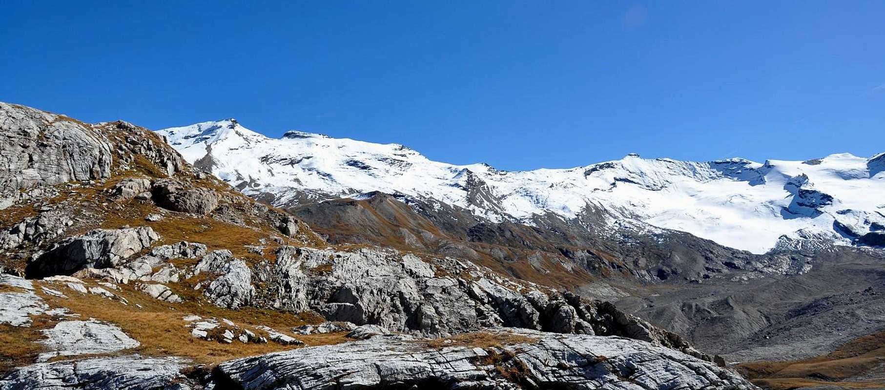
Last and important topographin knot between the valleys of Rhêmes (Valle d'Aosta), Ceresole (Piemonte) and Isère (France). On its Northwestern side a wide glacier while its Souteast and South sides comes down with two huge rock walls. Very good panoramic point on Gran Paradiso Group and Vanoise Massif (Iséran).
Estremo nodo e punto topografico importante tra le Valli di Rhêmes (Valle d'Aosta), Ceresole (Piemonte) e d'Isère (Francia). Si presenta con un versante glaciale a Nordovest e due pareti rocciose a Sudest ed a Sud. Ottimo punto panoramico sul Gruppo del Gran Paradiso e sul Massiccio della Vanoise nell'Iséran.
It therefore appears as a double-sided mountain: good-natured and covered by a large and expansive glacier on the Northern side, formed by the Southern sector of the Glacier de Lavassey which, to the West and below the Col de Basagne (3.110m), flows into the Glacier Oriental de Fond, while in the South (especially in the Southeast) it drops with steep and uninviting rocky walls. Although, in truth, there are also two small glaciers on this side:
1) - the first is located in the Southwest in the sector that joins Punta Galisia to the adjacent Roc de Basagne (about 3.222/8 meters), under the Galisia's Pass;
2) - the second, of tiny dimensions and in the process of disappearing, is "perched" to the South in the area that joins the Western Slope of the Galisia Pass to the Summit of the same name. These are both located in Val d'Isère, that is in France, while the first of Lavassey is completely in Italian territory. As well as Italian, but facing the Ceresole Valley in Canavese's Area (Piedmont Italian Region), is the vast Southeast Wall which unfolds, beyond of the Punta Basei (3.338m) and Punta Bousson (3.337m) and behind Colle del Nivolet or Nivolé (2.612m), like a fan furrowed by steep snowy-rocky gullies alternating with large ribs of brown-reddish rock, which linearly rise in parallel. It should also be noted that the French South Flank, above Réfuge de Prariond (2.320/4m), is the most modest of the three, compressed and "punctuated" by the two very small glaciers above, which the same rise to lick the little extreme rocks. The two border crests contain this restricted area:
a) - the West Northwest Crest, which descends towards the Col de Basagne (3.110m), delimits the border amongst French with Italy and the adjacent Aosta Valley;
b) - the Southwest separates from the Ceresole's lakes (Serrù and Agnel) at the peak of the Orco Valley in the Canavese area (Piedmont Region). The latter, which descends above the important Passo della Galisia (3.002m), is located between the Upper Val d'Isère and the High Canavese (area above the City of Ivrea).
Si presenta quindi come montagna double face: bonaria e ricoperta da un ampio e disteso ghiacciaio sul Versante Settentrionale, formato dal settore Meridionale del Glacier de Lavassey che, ad Occidente ed al di sotto del Col de Basagne (3.110 m), confluisce nel Glacier Oriental de Fond, mentre a Meridione (soprattutto a Sudest) lascia precipitare ripide e poco invitanti pareti rocciose. Anche se, per la verità, pure su questo lato esistono due piccoli ghiacciai:
1) - il primo si trova a Sudovest nel settore che unisce la Punta Galisia all'adiacente Roc de Basagne (3.222/8 metri circa), nonché al di sotto del Passo Galisia;
2) - il secondo, di dimensioni minuscole ed in via di appariscente disparizione, é "abbarbicato" a Meridione nell'area che unisce il Versante Occidentale del Passo della Galisia all'omonima Sommità. Questi sono entrambi situati in Alta Valle dell'Isère, ovvero in Francia, mentre il primo di Lavassey é completamente in territorio italiano. Così. Come italiana, ma rivolta verso la Valle di Ceresole in zona Canavesana (Piemonte), risulta la vasta nonché elevata Parete Sudest che si dispiega, al di là della Punta Basei (3.338 m) nonché della Punta Bousson (3.337 m) ed oltre il Colle del Nivolet oppure Nivolé (2.612 m), a ventaglio solcata da ripidi canaloni nevoso-rocciosi alternati a grandi costoloni di roccia bruno-rossastra, che linearmente salgono in parallelo. Ancora da osservare come il Versante Meridionale francese, al di sopra del Réfuge de Prariond (2.320/4 m), risulti come il più modesto dei tre, compresso e "punteggiato" dai due ghiacciaietti di cui sopra, che salgono a lambire le roccette estreme. Le due creste di confine (SO, sovrastante il Passo della Galisia, ed O-NO, affianco al Col de Basagne) contengono questa ristretta area:
a) - la Cresta Ovest-nordovest, che scende verso il Col de Basagne (3.110 m), delimita il confine tra la Francia con l'Italia e la Valle d'Aosta;
b) - quella Sudovest separa dai laghi di Ceresole (Serrù ed Agnel) al culmine della Valle dello Orco nella zona del Canavese (Regione Piemonte). Quest'ultima, che scende sopra l'importante Passo della Galisia (3.002 m), si trova a cavallo tra la Superiore Val d'Isère e l'Alto Canavese (area soprastante la Città di Ivrea).
First Ascents
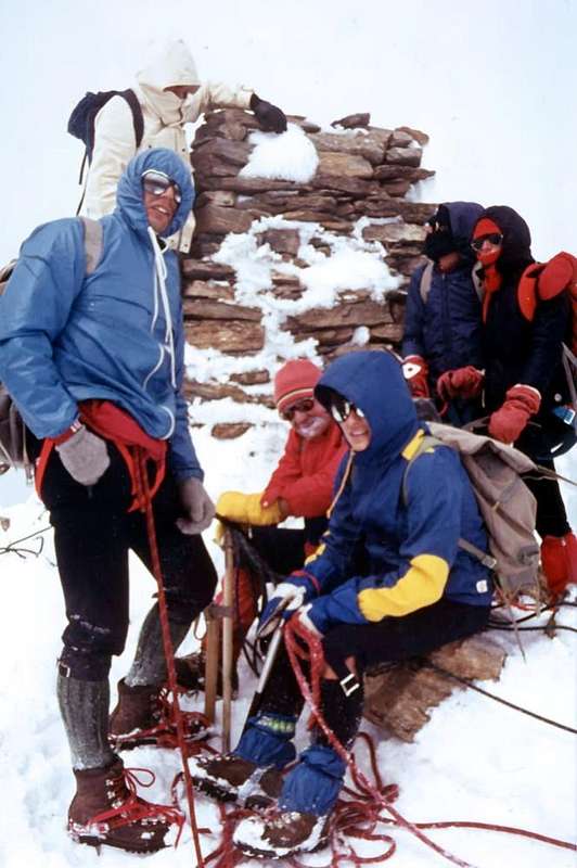
First on the Summit: Y. Hoelis, Georges Yeld, Alphonse Payot and Jean Martin, (Aug 17th, 1878).
In winter: unknown.
SW Slope: Y. Hoelis, Georges Yeld, Alphonse Payot and Jean Martin, (Aug 17th, 1878); in ascent from Galisia's Pass, Glacier and Glacier de Basagne in final part.
SW Slope (Direct Variant): Emilio C. Biressi and Mario Ambrosio, (Jul 10th, 1904); in ascent from Galisia's Glacier and through a difficult ledge on Western Face with direct ascent from North to the South reaching the Southern Antesummit in final part.
W-NW Ridge (from Col Basagne): unknown.
NW Slope (Italian Normal ski-mountaineering Route from Benevolo Refuge): William Auguste Brevoort Coolidge and Christian Almer Junior, (Sep 01th, 1886); in ascent through Western branch of Lavassey's Glacier just beyond the two yellowish Teths.
NW Slope: (Italian Standard Via from Benevolo Hut): unknown; in ascent through Eastern branch of Lavassey's Glacier and West Shoulder of Punta Bousson.
NE Crest (from Punta Bousson): Giovanni Bobba with Rhêmes Mountain Guide Casimiro Thérisod (Aug 16th, 1888); in descent arriving from Punta Galisia.
SE Face (Central Rib directly to Top) and North Crest in final: Enrico Marta and Giorgio Viale, (Aug 13th, 1970); in ascent from Ceresole to Pian della Ballotta.
SE Face (second couloir of left) and South Crest in terminal part: Osvaldo Cardellina and Marco Cossard, (Sep 30th, 1980); in ascent from Pont Valsavaranche, Nivolé's Tableland and Hill, Pian della Ballotta; in descent, after crossing on crest towards Punta Bousson and Punta Basei, through Eastern Slope of Basei Col.
SW Ridge (from Galisia's Pass): Unknown; in ascent from Val d'Isère or from Ceresole Valley reaching the Southern branch of Basagne Glacier in terminal part.
SW Ridge (Variant on integral Edge of the ridge always from Galisia's Pass): Adolfo Camusso, Mario Chiarabaglio, Sergio Crest and Paolo Maggi, (Sep 30th, 1970); in ascent from Ceresole Valley.
Integral traverse Punta Galisia to Punta Bousson-Punta Basei: Osvaldo Cardellina and Marco Cossard, (Sep 30th, 1980); in traverse, after ascent on Galisia's SE Couloir, through Eastern Slope of Basei Col.
Getting There
BY CAR:
From France: through the Mont Blanc Tunnel or the Col du Petit Saint Bernard: you can drive on SS.26, following directions for Aosta and, before arriving in Villeneuve, turn right towards Introd. Alternatively, you can take Motorway A5 (at Courmayeur or Morgex) and exit at Aosta Ovest.
From all the other directions: get to the Aosta Ovest exit of Motorway A5. Then drive on SS.26 Aosta, in the direction of Courmayeur; just after Villeneuve turn left towards Introd.
BY PLANE:
Aeroporto "Corrado Gex" Saint Christophe (Aosta).
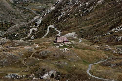
Enter the valley and, at the fork between Valsavarenche and Val di Rhêmes turn to the right (Rhêmes). Cross all the villages to arrive to Rhêmes Notre Dame and follow to Thumel (car parking), herefrom, following the dirt road on the right side (ascending) of the valley, or, better with snow, a track on the left that passing throught some fine woods leads you to the Rifugio Benevolo (2.285m)
Normal Route
From the "Rifugio Federico Benevolo" (2.285m) to follow toward South the path (13b) that conducts to the junction between the trails at Nivoletta and Basei Pass, to leave to the left the trace of this last and to go down of few reaching in the Glacier of Lavassey. To coast along him/it towards and under the Western very elongated Wall of the Punta Basei and to reach the terminal crevasses (dengerous in the central traverse) of the Western spallone (shoulder) of the Punta Bousson. To go up again I pour him/it and actually to the quota 3.276 meters, from where for wide and easy crest the peak is earned (4h'00/4h'30) from Federico Benevolo Refuge.
Dal Rifugio Federico Benevolo (2.285 m) seguire verso Sud il sentiero (13b) ad Oriente della Dora di Rhêmes che conduce al bivio tra i due sentieri per i Colli di Nivoletta e Basei; lasciare a sinistra la traccia di questo ultimo e scendere di poco raggiungendo il Ghiacciaio di Lavassey. Costeggiarlo ad Est sotto l'allungata Parete Ovest della Punta Basei (al centro pericolosi crepacci!) e raggiungere la crepaccia terminale dello spallone Ovest della Punta Bousson. Risalirlo (35°/40°) verso Est (spesso verglass) sino alla quota 3.276 m, da dove per larga e facile cresta si guadagna la vetta (4h'00/4h'30) dal Rifugio Federico Benevolo.
Difficulties of Standard Via
This route can be considered F+/PD-.
L'itinerario è classificato F+/PD-.
Gear
Mountaineering equipment, including rope, iceaxe, and crampons.
Da alta montagna, corda, picozza e ramponi.
GALISIA's ALL ROUTES
VARIOUS WAYS of ASCENT with RELATIVE DIFFICULTIES
A) - Northerner Routes As regards the characteristics and the technical difficulties with respect to the various climbs, it should be noted that Punta Galisia does not offer extreme level itineraries; rather, it offers beautiful ski-mountaineering climbs along the Lavassey or Fond Glaciers, both in their Eastern branch, on the Italian side of Rh & ecirc; mes and the Glacier de Basagne in the upper Val d'Isère. Despite some recommendations we must make it:
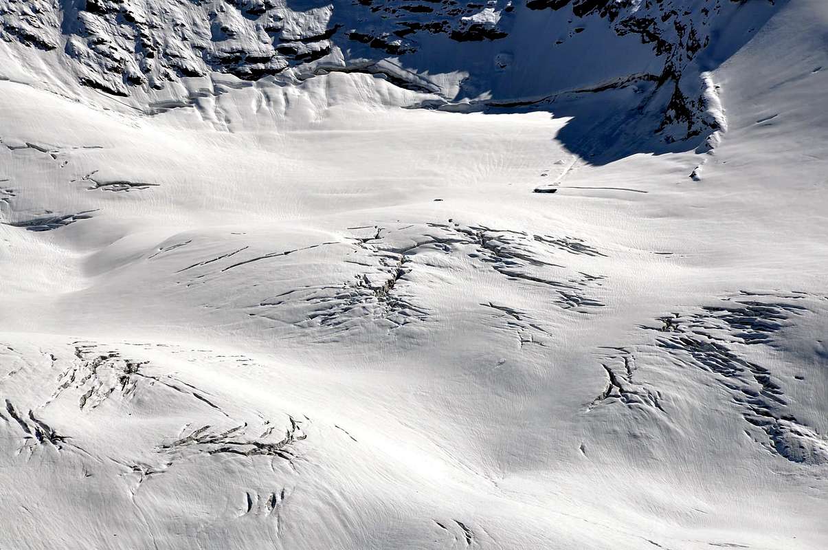
a) - always pay absolute attention to the state of the glaciers that can hide unexpected crevasses. The Glacier Oriental de Fond (the one on which the ascent was made in September 1886) stretches towards the SE starting from the altitude of (about 2.776/2.800 meters), between the NW shoulder of Punta Bousson (3.337m; the characteristic one for the two yellowish gendarmes, in view also from the Benevolo Refuge), the Col de Basagne (3.110m) and the N-NE Face of the Roc de Basagne, from the bases at an altitude of 2.800/2.977 meters. Of a "good-natured" aspect, it should not be underestimated.
b) - the other possible route climbs up with path n° 13 to Colle Basei (3.176m) leaving the same where it splits for Col Nivoletta (or Nivolettaz; 3.130m) and moving to the Lavassey Glacier at an altitude of approximately 3.000/3.020 meters. Here it is worth giving important information: the route in the center of the plateau is really dangerous, especially in the hottest hours (from personal experience on October 4th 1986 at about 2.00' pm on the return from Galisia and on the shoulder of the Punta Bousson we saw the center of the glacier explode with a cannon shot and the relative opening of a rounded hole with a diameter of about twenty meters), where we were in doubt whether to pass or redo the archway at the base of Punta Basei ); It is certainly worth staying more up a good hundred meters . Widening the arc and passing to the bases of the West Wall of the Punta Basei (3.338m) and the North Face of the Bousson. To then go up to the Western almost at the end of the NW shoulder between the 2.955 heights/3.141 meters and cut diagonally towards the Top, aiming at the rounded yellow-orange rock, just below the Summit. Or,
c) - climbing the ridge edge of the Northwestern shoulder to the nearby Punta Bousson (3.337m) and
d) - then cross the watershed edge with the NE Ridge in terminal part (August of 1888 Route). But also
e) - in a complete traverse between Punta Basei, Punta Bousson and Punta Galisia, as the Osvaldo Cardellina and Marco Cossard team did, in the South / North direction and therefore downhill from the last one, on 30 September 1980 after having climbed the Southeastern Couloir, above Pian della Ballotta (2.577m), with a beginning an altitude of around 2.756/2.760 meters up to the final part of SW Ridge. All these routes have in common, as their starting point, the Federico Benevolo Refuge (2.285/7m); or, if carried out during the day, the start takes place at the beginning of the path after Thumel (1.903m; extensive signs and reports on pannel).
B) - Southernoriental Routes Passing on the other or Southeastern side, facing above the terminal part of the Valle dell'Orco (Pian delle Gavite under the Bousson and Pian della Ballotta under the Galisia), it should be emphasized that the routes on this side, either on rock or in snow, they are dangerous.
f) - Both the primitive route on the SE Rib of Punta Bousson and crossing to the hill of the same name (about 3.320 meters in B&V, page 151), to then conclude with the North Crest (described by B&V in "Guide to the Western Alps" , 1986, page 138: "f) For the south-east side.", by unknown ascenders; both the old street
g) - of 15 August 1919 by Ettore Ghiglione, Adolfo Hess and Pierino Paissa (as per "Monthly Magazine of the CAI", 1921, pp. 1-6) with a similar itinerary using the via alla Bousson di Bobba, Cibrario and Vaccarone of 15 August 1890 and then traversing to the left on rocky ribs and snow-covered canals in the last part, are to be considered as "archaic" and never repeated. The difficulties can reach, with a bottom-up and therefore approximate analysis, at most the III °, but what is necessary is to know how to decipher the path (certainly dangerous in the end because possible stones falls). Two more recent routes follow: the first
h) - of 13 August 1970 by Enrico Marta and Giorgio Viale crosses the SE Spur-Crest, formed at the base by a brown-reddish rock trapezoid and then following the line on the vertical of the Vetta with passages from III° to V°, but almost all can be circumvented with less difficulty on very broken rocks, exiting in the final on the right (North) of the Summit (itinerary that is not again repeated, completed in 4h'30 and with the use of 5 pitons, of which 2 left on site). The second
i) - of 30 September 1980 by a group of mountaineers from Aosta, which directly passed the rocky-snowy gully immediately to the left of the previous itinerary with a climb completely on ice of almost 650 meters, slopes from 35°/40° to almost 50°/60° and exit out just South of the Top; on the occasion, then, they crossed, thus bypassing the Summits of Bousson and Basei, up to Colle Basei (3.176m). The departure for all these itineraries should be made from the Pian della Ballotta Refuge (2.440m), just West of Lake Serrù; but also, if you wish and arriving from Pont Valsavarenche, from the Città di Chivasso (2.600m) or Savoia (2.610m) Refuges at the Colle del Nivolé (2.612m) with subsequent short descent towards Agnel Lake (2.297m) and the Serrù Lake (2.278m).
C) - Meridional or French Vie Ultimately, the border crests with the SW between the Upper Isère Valley (French) and the terminal part of the Orco Valley in Canavese (Piedmont Region), or on the border between Italy and France. This watershed rises from the Galisia Pass (2.987/3.002m) to the Vetta and was traveled with
l) - a partial route more or less along the ridge and then in the upper part crossing to the left (West) towards the Glacier de Basagne and with this to conclude. Or
m) - with a direct variant of the consortium of September 1970 which, remaining for the most part on the border, reached the Summit with passages from II°- up to the III°. Beyond the SW flank the first ascenders of August 1878 traveled north up the small Glacier de Galisia (unnamed in Italian cartography, as well as endangered) reaching the rocky wall at the base of Glacier de Basagne; through channels alternating with a series of ledges, on very broken rock and debris, they reached the upper part of Glacier de Basagne and with this the Cima. A variant
n) - was opened on this route in July 1904 - by Emilio C. Biressi and Mario Ambrosio who, through a difficult ledge on the Western Face and traveled from North to South, reached the Southern Ante Summit located right at the junction of the SW and W Crests -NO. Probable difficulties from I°+ up to the III° for an "obsolete" and never repeated path. Good last
o) - the W-NW Crest that climbs without any difficulty from Col Basagne (3.110m) using the rump that forms the edge of the homonymous glacier. The logistic support points consist, as for point B, from the two refuges at the end of Pian del Nivolé or, better, from that of Pian della Ballotta (2.577m) for the SW Ridge, if climbed from the Italian side; otherwise from the Réfuge de Prariond (2.440m) starting from the French one. All the other itineraries to follow always depend on this last one.
VARIE VIE di SALITA con RELATIVE DIFFICOLTA'
A) - Vie Settentrionali Per quanto concerne le caretteristiche e le difficoltà tecniche rispetto alle varie salite, vi é da annotare come la Punta Galisia non offra itinerari di estremo livello; bensì propone piuttosto delle belle salite di stampo sci-alpinistico percorrendo i Ghiacciai di Lavassey o di Fond, entrambi nel lor ramo Orientale, sul lato italiano di Rhêmes ed il Glacier de Basagne nell'alta Val d'Isère. Ciononostante qualche raccomandazione dobbiamo effettuarla:
a) - prestare sempre assoluta attenzione allo stato dei ghiacciai che possono celare imprevisti crepacci. Il Glacier Oriental de Fond (quello sul quale venne effettuata la salita nel settembre del 1886) si distende verso SE a partire dall'altitudine di (circa 2.776/2.800 metri), compreso tra lo spallone NO della Punta Bousson (quello caratteristico per i due gendarmi giallastri, in vista anche dal Rifugio Benevolo), il Col de Basagne (3.110 m) e la Parete N-NE del Roc de Basagne, dalle basi a quota 2.800/2.977 metri. Di aspetto "bonario", é comunque da non sottovalutare.
b) - l'altra via possibile sale con il sentiero n° 13 per il Colle Basei (3.176 m) abbandonando il medesimo laddove si sdoppia per il Col Nivoletta (o Nivolettaz; 3.130 m) e trasferendosi sul Ghiacciaio di Lavassey a quota 3.000/3.020 metri circa. Qui conviene dare un'informazione importante: il percorso nel centro del plateau é veramente pericoloso, soprattutto nelle ore più calde (per esperienza personale il 4 di ottobre 1986 alle 14.00' circa al rientro dalla Galisia e sullo spallone della Bousson abbiamo visto esplodere il centro del ghiacciaio con una cannonata e relativa apertura di un buco arrotondato dal diametro di circa una ventina di metri, dove eravamo in dubbio se passare o rifare il giro ad arco alla base della Parete Ovest della Punta Basei); conviene sicuramente restare più in alto di un buon centinaio di metri. Allargando il giro ad arco e passando alle basi della Parete Ovest della Basei (3.338 m) e di quella Nord della Bousson. Per poi risalire all'estremità Occidentale dello spallone N-O tra le Quote 2.955/3.141 metri e tagliare in diagonale verso la Vetta, tenendo di mira il roccione giallo-arancione arrotondato, subito al di sotto della Sommità.
c) - Oppure, salendo per il filo di cresta dello spallone Nordoccidentale alla vicina Punta Bousson (3.337 m), per poi
d) - attraversare sul filo dello spartiacque con la Cresta NE (Via dell'agosto 1888). Ma anche
e) - in completa traversata tra Punta Basei, Punta Bousson e Punta Galisia, come fece la cordata di Osvaldo Cardellina e Marco Cossard, nel senso Sud/Nord e quindi in discesa dall'ultima, il 30 Settembre 1980 dopo aver salito il Canalone Sudorientale,, sopra il Pian della Ballotta (2.577 m), con inizio a quota 2.756/2.760 metri circa. Tutte queste vie hanno in comune, come punto di partenza, il Rifugio Federico Benevolo (2.285/7 m), oppure, se in giornata, l'avvio avviene all'inizio del sentiero dopo il Villaggio di Thumel (1.903 m; ampie segnalazioni su panneaux).
B) - Vie Sudorientali Passando sull'altro lato o Sudorientale, rivolto al di sopra della parte terminale della Valle dell'Orco (Pian delle Gavite sotto la Bousson e Pian della Ballotta sotto la Galisia), é da sottolineare che le vie su questo versante, sia su roccia oppure in neve, sono piuttosto pericolose.
f) - Sia la primitiva via sulla Costola SE della Punta Bousson e traversata al colle omonimo (3.320 metri circa in B&V), per poi concludere con la Cresta Nord (descritta da B&V in "Guida delle Alpi Occidentali", 1986, pag. 138: "f) Per versante sud-est.", ad opera di salitori sconosciuti; sia la vecchia via
g) - del 15 agosto 1919 ad opera di Ettore Ghiglione, Adolfo Hess e Pierino Paissa (come da "Riv. Mensile del CAI", 1921, pagg. 1-6) con itinerario similare utilizzando la via alla Bousson di Bobba, Cibrario e Vaccarone del 15 agosto 1890 e poi con traversata non semplice e pericolosa a sinistra su costole rocciose e canali innevati nell'ultima parte, sono da considerarsi come "arcaiche" e mai più ripetute. Le difficoltà possono raggiungere, con analisi dal basso e dunque approssimativa, al massimo il III°, ma quello che é necessario consiste nel saper decifrare il percorso (sicuramente pericoloso nel finale per possibili cadute di sassi). Seguono due vie più recenti: la prima
h) - del 13 agosto 1970 ad opera di Enrico Marta e Giorgio Viale supera lo Sperone SE, formato alla base da un trapezio di roccia marrone-rossastra e poi seguendo la linea sulla verticale della Vetta con passaggi dal III° al V°, ma quasi tutti aggirabili con minori difficoltà su rocce molto rotte, uscendo nel finale sulla destra (Nord) della Vetta (itinerario che non risulta ripetuto, compiuto in 4h'30 e con l'uso di 5 chiodi, dei quali 2 lasciati in loco). La seconda
i) - del 30 settembre 1980 ad opera di una cordata di alpinisti aostani, che superò direttamente il canalone roccioso-nevoso subito alla sinistra del precedente itinerario con salita di quasi 650 metri, pendenze da 35°/40° a quasi/50°/60° ed uscita appena a Sud della Cima; nell'occasione, poi, i medesimi attraversarono, scavalcando quindi le Sommità di Bousson e Basei, fino al Colle Basei (3.176 m). La partenza per tutti questi itinerari conviene effettuarla dal Rifugio Pian della Ballotta (2.440m), appena ad Ovest del Lago Serrù; ma anche, volendo ed arrivando da Pont Valsavarenche, dai Rifugi Città di Chivasso (2.600 m) o Savoia (2.610 m) presso il Colle del Nivolé (2.612 m) con susseguente breve discesa verso il Lago dell'Agnel (2.297 m) ed il Lago Serrù (2.278 m).
C) - Vie Meridionali o Francesi In ultima analisi le creste di confine con la SO tra l'Alta Valle dell'Isère e la parte terminale della Valle dell'Orco in Canavese, ovvero al confine tra Italia e Francia. Questo spartiacque sale dal Passo della Galisia (2.987/3.002 m) alla Vetta e venne percorso con
l)- un percorso parziale più o meno sul filo di cresta per poi nella parte alta attraversare a sinistra (Ovest) verso il Glacier de Basagne e con questo facilmente concludere. Oppure
m) - con una variante diretta della cordata del settembre 1970 che, restando per gran parte sul confine, raggiungeva la Sommità con passaggi dal II°- fino al III°. Oltre il Versante SO veniva percorso dai primi salitori dell'agosto 1878, risalendo verso Nord il piccolo Glacier de Galisia (innominato nella cartografia italiana, nonché in via di estinzione) raggiungendo la muraglia rocciosa alla base del Glacier de Basagne; tramite canalini alternati ad una serie di cenge, su roccia molto rotta e detriti, raggiungevano il Glacier de Basagne e con questo la Cima. Su questa via nel luglio 1904 venne aperta una più complessa che difficile variante
n) - da Emilio C. Biressi e Mario Ambrosio che, tramite una difficile cengia sulla Parete Occidentale e percorso da Nord a Sud, raggiungeva l'Antecima Sud posta proprio alla congiunzione delle Creste SO ed O-NO. Probabili difficoltà dal I°+ fino al III° per un percorso "obsoleto" nonché mai più ripetuto. Buon ultima
o) - la Cresta O-NO che sale senza difficoltà alcuna dal Col Basagne (3.110 m) sfruttando il groppone che costituisce l'orlo dell'omonimo ghiacciaio. I punti di appoggio consistono, come per il punto B, dai due rifugi al termine del Pian del Nivolé oppure, meglio, da quello del Pian della Ballotta per la Cresta SO, se salita dal versante italiano; altrimenti dal Refuge de Prariond (2.440 m) con partenza da quello francese. Tutti gli altri itinerari a seguire dipendono da quest'ultimo.
The Eastern side of the valley belongs to Gran Paradiso National park, the Western one is out of the boundaries of the Park ... but nature must be respected.
Campings
Remember that free camping is forbidden (except for emergency reasons, over 2.500m, from darkness until dawn).
Mountain Conditions
You can get meteo information at the official site of the Regione Valle d'Aosta:
"Guida delle Alpi Occidentali" di Giovanni Bobba e Luigi Vaccarone C.A.I. Sezione di Torino Volume II (parte II), 25 Maggio 1896.
"Guida dei Monti d'Italia-Gran Paradiso Parco Nazionale" E. Andreis, R. Chabod, M. C. Santis, Club Alpino Italiano/Touring Club Italiano, prima Ed. 1939; seconda Ed. 1963; terza Ed.
"Guida della Regione Autonoma Valle d'Aosta" di Mario Aldrovandi,Ed. S.P.E. di Carlo Fanton, Torino 31 Dicembre 1964.
"Rifugi e bivacchi in Valle d'Aosta", di Cosimo Zappelli aggiornata da Pietro Giglio, Musumeci Editore, Luglio 2002.
"Diari Alpinistici" di Osvaldo Cardellina e Indice Generale accompagnato da Schedario Relazioni Ascensioni 1964-2019 (inediti).
MAPS:
Kompass "Gran Paradiso Valle d'Aosta Sentieri e Rifugi" Carta Turistica 1:50.000.
Enrico Editore Ivrea-Aosta "Gruppo del Gran Paradiso" 1:50.000.
I.G.C. Istituto Geografico Centrale Carta dei sentieri e dei rifugi "Valsavarenche-Val di Rhêmes-Valgrisenche" 1:25.000.
Parents refers to a larger category under which an object falls. For example, theAconcagua mountain page has the 'Aconcagua Group' and the 'Seven Summits' asparents and is a parent itself to many routes, photos, and Trip Reports.

 8860 Hits
 86.85% Score
 23 Votes