
-
 7858 Hits
-
 86.37% Score
-
 22 Votes
|
|
Mountain/Rock |
|---|---|
|
|
45.49594°N / 7.11931°E |
|
|
Mountaineering |
|
|
10735 ft / 3272 m |
|
|
Overview
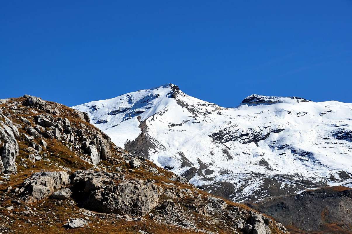
Placed on the watershed between Val di Rhemes (W) and Nivolè highland (Valsavarenche), not far from Rifugio Gian Federico Benevolo, this is an easy climbing mountain. Wonderful views on Nivolè Lakes, Gran Paradiso and Levanne Groups, Aiguille de la Grande Sassiere and the whole Rhêmes Valley.
Situata sulla cresta spartiacque Valle di Rhêmes Pian del Nivolè (Valsavarenche), relativamente vicina al Rifugio Gian Federico Benevolo, è montagna facile da salire. Splendide vedute sui Laghi del Nivolè, Gran Paradiso, Levanne, Aiguille de la Grande Sassiere e tutta la Valle di Rhêmes.
First Ascents
- First on the summit (Punta N): P. Puiseux and L. Boutan, (Aug 14th, 1877).
- First on the summit (Punta S): Gianni Bobba, L. Lanier and C. Thomasset, (Aug 13th, 1889).
- In winter (Punta N and S): Unknown.
- S-SW Arête (from Cime di Nivoletta): P. Puiseux and L. Boutan, (Aug 14th, 1877).
- NW Slope (of Punta N): Unknown.
- N-W Arête (of Punta N, normal route): Unknown.
- N-NE Ridge (of Punta N): F. E. Bertucci, Giovan Battista Bozzino and A. Virgilio, (Aug 29th, 1909), in descent.
- E Arête (of Punta S): Giovanni Brogliatto, solo (Aug 13th, 1958).
- Great Crossing (P. di Lavassey - P. di Paletta - N and S - Gran Vaudala N and S - Cime di Nivoletta N and S - P. Basei W Wall, in descent - P. Bousson - N - N Wall in ascent): Osvaldo Cardellina and Giuseppe Lamazzi, (Jul 21th, 1974).
- Great Crossing S/N: (Punta Basei - Cime di Nivoletta S and N - Gran Vaudala S and N - Punta del Rosset - Punte del Leynir S and N - Punta Celestino Bess): Osvaldo Cardellina, Marco Cossard, Camillo Roberto Ferronato, Giuseppe Lamazzi, Nino Trapani and Nino Sandretto (until Punta del Rosset), (Jul 28th, 1974).
Getting There
BY CAR:- From France, through the Mont Blanc Tunnel or the Col du Petit Saint Bernard: you can drive on SS.26, following directions for Aosta and, before arriving in Villeneuve, turn right towards Introd. Alternatively, you can take Motorway A5 (at Courmayeur or Morgex) and exit at Aosta Ovest.
- From all the other directions: get to the Aosta Ovest exit of Motorway A5. Then drive on SS.26 Aosta, in the direction of Courmayeur; just after Villeneuve turn left towards Introd.
- Aeroporto "Corrado Gex" Saint Christophe (Aosta).
 |
 |
 |
 |
 |
Route
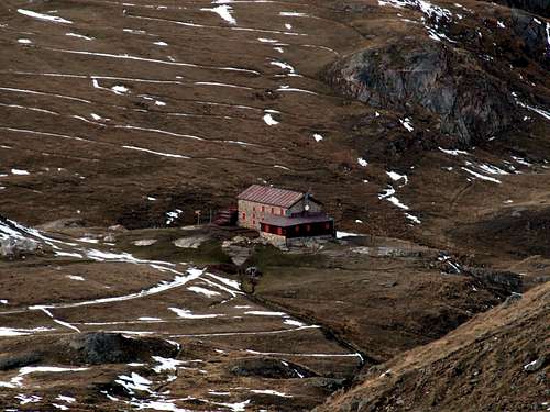
From the "Rifugio Benevolo" follow the path (13b) to the Nivoletta and Basei Pass, leave it at an altitude of 2.570 meters and go up a small valley to the east, reaching a small lake. Pastures and small snowfields to reach the Gran Vaudala Pass to ~3.000 meters (2h'30). From this point there are two possible routes (1°) continue along the easy ridge NW to easy rock routes up to the summit (1h'00/3h'30). (2°) continue to left on the Gran Vaudala Glacier and slopes of 30°/38° to reach the Punta Nord (1h'00/3h'30). At 0'15 for the S-SW ridge is easy to reach Punta Sud (3.250m).
Dal Rifugio Benevolo seguire il sentiero (13b) che conduce ai Colli di Nivoletta e Basei, abbandonarlo a quota 2.570 metri e risalire verso est un piccolo vallone raggiungendo un laghetto. Per pascoli e piccoli nevai raggiungere il Colle della Gran Vaudala a 3.000 metri~ (2h'30). Da questo punto sono possibili due itinerari: (1°) continuare sulla facile Cresta NW per facili rocce rotte sino in vetta (1h'00/3h'30): (2°) continuare a sinistra sul Ghiacciaio della Gran Vaudala e per pendii di 30°/38° raggiungere la Punta Nord (1h'00/3h'30). In 0'15 per la cresta S-SW si raggiunge facilmente la Punta Sud (3.250 m).
Difficulties
This route can be considered EE.
L'itinerario è classificato EE.
Equipment for the Route
Standard mountaineering equipment. Ice axe and crampons for Route (2).
Huts
 |
Red Tape
The Eastern side of the valley belongs to Gran Paradiso National park, the Western one is out of the boundaries of the Park ... but nature must be respected.
Campings
Remember that free camping is forbidden (except for emergency reasons, over 2.500m, from darkness until dawn).
Mountain Conditions
- You can get meteo information at the official site of the Regione Valle d'Aosta:
- Valle d'Aosta Meteo
- Meteo: You can find more weather information on the website 3B Meteo:
- Meteo Rhemes Notre Dame
Webcam
- WEBCAM on Aosta Valley:
- Webcam
Books and Maps
BOOKS:
- "Guida delle Alpi Occidentali" di Giovanni Bobba e Luigi Vaccarone C.A.I. Sezione di Torino Volume II (parte II), 25 Maggio 1896.
- "Guida dei Monti d'Italia-Gran Paradiso Parco Nazionale" E. Andreis, R. Chabod, M. C. Santis, Club Alpino Italiano/Touring Club Italiano, prima Ed. 1939; seconda Ed. 1963; terza Ed.
- "Guida della Regione Autonoma Valle d'Aosta" di Mario Aldrovandi, Ed. S.P.E. di Carlo Fanton, Torino 31 Dicembre 1964.
- "Rifugi e bivacchi in Valle d'Aosta", di Cosimo Zappelli aggiornata da Pietro Giglio, Musumeci Editore, Luglio 2002.
- "Diari Alpinistici" di Osvaldo Cardellina e Indice Generale accompagnato da Schedario Relazioni Ascensioni 1964-2019 (inediti).
- "80 itinerari di Escursionismo Alpinismo e Sci Alpinismo in Valle d'Aosta", di Osvaldo Cardellina, Ed. Musumeci, Giugno 1977 (in Italian); seconda Ed. Luglio 1981; terza Ed. Luglio 1984; (in French), prima Ed. Febbraio 1978; seconda Ed. Marzo 1980.
 |
 |
 |
 |
 |
MAPS:
- Kompass "Gran Paradiso Valle d'Aosta Sentieri e Rifugi" Carta Turistica 1:50.000.
- Enrico Editore Ivrea-Aosta "Gruppo del Gran Paradiso" 1:50.000.
- I.G.C. Istituto Geografico Centrale Carta dei sentieri e dei rifugi "Valsavarenche-Val di Rhêmes-Valgrisenche" 1:25.000.
Important Information
- REGIONE AUTONOMA VALLE D'AOSTA the official site.
- FONDAZIONE MONTAGNA SICURA Villa Cameron, località Villard de la Palud n° 1 Courmayeur (AO) Tel: 39 0165 897602 - Fax: 39 0165 897647.
- SOCIETA' GUIDE ALPINE DEL GRAN PARADISO Comune di Valsavarenche.
- A.I.NE.VA. (Associazione Interregionale Neve e Valanghe).
Useful Numbers
- Protezione Civile Valdostana località Aeroporto n° 7/A Saint Christophe (Ao) Tel. 0165-238222.
- Bollettino Meteo (weather info) Tel. 0165-44113.
- Unità Operativa di Soccorso Sanitario Tel. 118.