Aug 29th, 2017 Started to modify the page and the other sections.
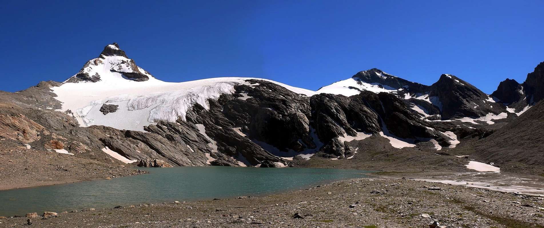
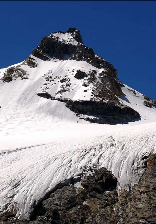
It looks like highest point of the rocky ridge starting from Col della Tsanteleina and shares out the Goletta Glacier with the heading glaciers of Valle di Rhêmes. It's one of the most goodlooking mountain of the area, expecially if seen from the Village of Rhêmes Notre Dame, sited just to the North. The name "Granta Parei", in the local dialect, is clearly arising from the italian name "Grande Parete", which in english means "Big Wall". In fact, this mountain is basically a four angles pyramid, with the huge Eastern rocky Wall rising for about 500 meters above the glacier. It's the first showy thing to see when coming from the bottom of the valley, where offers the Northern and Eastern Walls. Despite the nice shape, this mountain is for the most part composed of bad quality rocks, expecially on the Western Face (on which passes the Normal Way or Normal Route), mixed with icy gullies, a rocky-detritic narrow stretch, followed by a final part rocky-debris or snow slopes, immediately below the summit collar 3.385 meters, between the two Summits.
Risulta qual punto più elevato della cresta rocciosa dal Col della Tsanteleina ed appartenente al Ghiacciaio di Goletta nella voce ghiacciai della Valle di Rhêmes. È una delle montagne più belle della zona, soprattutto se osservata dal Villaggio di Rhêmes Notre Dame posto appena a Settentrione, dove la strada si indirizza verso il Comune di Villeneuve e la Valle Centrale della Dora Baltea. Il nome "Granta Parei" è chiaramente derivato dal nome italiano "Grande Parete", così definito nell'idioma locale, che in inglese significa "Big Wall". Infatti, questa montagna è fondamentalmente una piramide a quattro angoli, con l'enorme fianco roccioso Orientale che sinnalza di ben 500 metri sopra il ghiacciaio. È la prima cosa in gran vista quando si arriva dal fondo della valle, dove offre le pareti Nord ed Est. Nonostante la bella forma, questa montagna è per la maggior parte composta da rocce di qualità scadente, specialmente sul Versante Occidentale (sul quale passa la Via Normale), alternato a ghiaccio con canalini ed una strettoia rocciosa detritica che conduce all'ultima parte detritico-rocciosa o con pendii nevosi, appena sotto il collare sommitale.
First Ascents
First on the Summit (North-northwest Ridge and West Slope in final part): R. C. Nichols, T. Blanford and E. P. Rowsell with mountain Guides J. V. Favret and N. Jacod, (Aug 22th, 1863).
In winter: Emanuele Andreis, F. P. and S. Ceresa, M. De Benedetti and R. Henking, by ski through the West Slope along the Standard Via.
West Face, Direct Route to Southern Summit: Osvaldo Cardellina, Sergio Roverso and Nino Trapani, (Jul 14th, 1974), in day from Rhêmes Notre Dames and crossing on Glacier de Goletta to Traversière Becca with descent towards Bassac Déré Pass.
Western Slope, Normal Route: William Auguste Brevoort Coolidge and mountain Guide Christian Almer, (Sep 25th, 1886).
West Wall, Direct Via to Northern Summit: Osvaldo Cardellina and Reinhart Lohrmann, (Jul 28th, 1968), and crossing Goletta's Glacier towards Traversière Becca and Bassac Déré Pass.
Northwest Little Couloir: Lorenzo Merli and Raffaele Piller, (July 10th, 1983), from Benevolo Shelter through Goletta's Glacier.
Northwest Ridge: R. C. Nichols, T. Blanford and E. P. Rowsell with mountain Guides J. V. Favret and N. Jacod, (Aug 22th, 1863); first integral ascent: A. Garino with mountain Guide Casimiro Thérisod, (Aug 15th, 1901).
North Wall: P. F. Quaini, (1913) in descent; Erasmo Barisone, I. Brosio and O. Crudo, (May 25th, 1924), in ascent.
Northeast Ridge: Pompeo Viglino with Companions (1911), Barberi, Gerboni and Gherra, (Aug 13th, 1929).
East Great Wall (Folli/Tardito Via): Mimo Folli and Aldo Tardito, (Aug 1/2/3th, 1968).
East-southeast Wall: Luigi Binaghi, Aldo Bonacossa and Ninì Pietrasanta, (Sep 06th, 1962).
Southern Crest: A. and E. Pigeon with mountain Guides Jean Joseph Maquignaz and Daniel Balley, (Jul 26th, 1875).
Southwest Flank: Giovanni Bobba and Casimiro Thèrisod, (Jul 24th, 1888).
West-sothwest Edge of triangular West-southwest Face: Osvaldo Cardellina, solo, (Jul 20th, 1997), in day from Pellaud Village.
Getting There from France & Switzerland
From Italy
From Valgrisenche:From the motorway A5 Monte Bianco (from Geneve, Turin, Milan), take the exit Aosta Ovest and follow the direction to Arvier-Valgrisenche.
From Val di Rhêmes:
From the motorway A5 Monte Bianco (from Geneve, Turin, Milan), take the exit Aosta Ovest and follow the direction to Villeneuve-Val di Rhêmes.
From France:
From Val d'Isere:From the village of Val d'Isere, enter in the area called "Reserve Naturelle de la Grande Sassiere". From here, few routes, through Col de Rhêmes Goletta and Col de la Tsanteleina, permit to reach the Italian side at the foot of this mountain.
From Others parts:
Is possible to reach the Aosta Valley also through the: France-pass of Piccolo St. Bernardo (closed in winter). France-Tunnel of Mont Blanc. Swiss-Tunnel of Grand St. Bernardo. Swiss-Pass of Grand St. Bernardo (closed in winter).
BASE APPROACH to NORMAL ROUTE with two VARIANTS
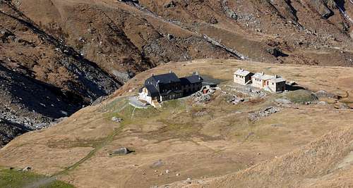
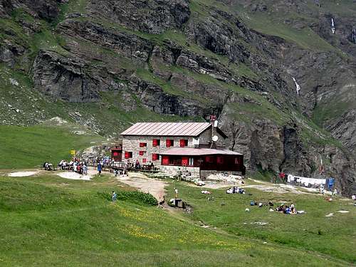
Approach to Goletta's Glacier at the base of standard Route From Federico Benevolo Refuge go down (SW direction) at small bridge (2.269m) over Rhêmes Dora Stream; by a diagonal path 13d, HRG (High Glacial Route) go to the fork (2.420m, (little cairn); leaving to the left (South) the path 13c (toward Truc Saint-Hélène and Tsanteleina Lake), turn right (Northwest) climbing the grassy promontory (2.615m). Change again direction (South-southwest) and reach the last ramification of Granta Parei long North-northeast Spur. Continue below the crest to the right (West), by obvious trace and white limestones debris to quota (3.078m) at the beginning of North-northeast Ridge; turn 90 degrees West and cross the Higher Goletta Glacier staying high, below the Northern Face, skirting North-northwest Ridge at about 3.080/90m. Turn South and, by a progressive diagonal ascent, reach the start of the Western Slope routes or Normal Routes. (2h'00/2h'15).
Dal Rifugio Federico Benevolo scendere a Sudovest al sottostante ponticello (2.269 m) sulla Dora di Rhêmes; risalire a Nordovest in diagonale all'alpe di Sauches (2.313 m) con il sentiero 13d, HRG (Alta Via Glaciale), sino al bivio (2.420 m, ometto); lasciando a sinistra (Sud) il sentiero 13c (verso il Truc Sant'Elena ed il Lago della Tsanteleina), girare a destra (Nordovest) e risalire l'erboso promontorio (2.615 m). Cambiare ancora direzione, salendo le estreme propaggini del lungo Contrafforte Nord-nordest della Granta Parei. Procedere sottocresta ad W su evidenti tracce risalendo detriti e blocchi di bianco calcare sino a quota (3.078 m), all'inizio della Cresta Nord-nordest; girare ad angolo retto ad Ovest ed attraversare in quota l'Alto Ghiacciaio di Goletta, sotto la Parete Nord, sino a doppiare lo Spigolo Nord-nordovest a quota 3.080/90 m~ Con progressiva salita diagonale ai margini del ghiacciaio, dirigersi a Meridione portandosi verso i varii attacchi delle vie del Versante Ovest o Via Normale. (2h'00/2h'15).
WESTERN STANDARD VIA & VARIANTS
A) - Western Slope, Normal Route towards Saddle (3.385m~) between the two Summits: to cross in right (S) half West Slope moving in centre; to go up the snowy slope (30°) up to a rocky narrowing (forced passage, very often frozen; dangerous for rocks falls together with numerous a group of rope climbers); to climb in right (S), by greats footholds with ice, also in left through a frozen "chimney" and to reach at higher debris and snowy slope (always "verglass"). To aim the "carving" between two summits, more to South. To cross in right (S) toward major Summit (3.387m) and in left (N), by a easy but exposed small crest, to North or traditional Summit (3.383m~). (F+; 1h'30).
A) - Via normale del Versante Ovest alla Sella (3.385 m~) tra le due Sommità: attraversare a destra metà del Versante Ovest portandosi al centro con salita diagonale per il facile pendio nevoso (30°); raggiungere una strozzatura rocciosa (spesso ghiacciata e pericolosa per cadute di pietre in presenza di molte cordate). Superarla o a destra (S) per gradoni spesso gelati oppure a sinistra. Per un camino quasi sempre verglassato; superato questo passaggio forzato ci si immette al pendio superiore di roccette, detriti "legati" dal ghiaccio; mirare all'intaglio tra le due cime, uscendo più vicino alla Punta Sud. Sulla cresta sommitale, a destra facilmente alla Vetta più elevata (3.387 m); a sinistra con una crestina facile e divertente, ma esposta ad E, alla Cima tradizionale (3.383 m~). (F+; 1h'30).
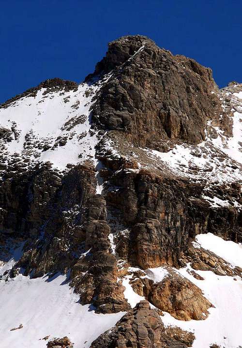
B) - W Wall, direct route to Northern Summit: to begin in perpendicular route to North Summit, between "canalino" (ice gully) and normal route. To go up by a progressive snowy slope (30°/33°/36°) toward a first rocky strip; to climb (II°/II°+) and to "touch" a first and brief debris balcony. By a short rocky passage to reach a second, more large and steep. To climb through rubbles and broken rocks at terminal of wall base, in quota (3.250m~); to overcome, nearly directly (from right to left), by broken and difficult rocks, to North Summit (AD+; II°+/III°+, a passage IV°-; 2h'00/2h'30).
B) - Parete Ovest, via diretta alla Punta Nord: iniziare perpendicolarmente alla Cima Nord, tra la via del canalino e la "normale" del Versante Ovest. Salire il pendio nevoso con pendenze in progressivo aumento (30°/33°/36°) dirigendosi ad una prima fascia rocciosa; superarla (II°/II°+) toccando una prima cengia detritica. Con un breve passaggio roccioso raggiungerne una seconda più ampia e ripida di rocce rotte e detrito, alla base del ripido muro terminale a quota (3.250 m~). Salirlo quasi direttamente da Sud a Nord su roccia rotta e difficile uscendo sulla Punta Settentrionale (AD+; II°+/III°+, un passaggio di IV°-; 2h'00/2h'30).
C) - Western Face, direct route to South Summit: to cross in right (S) the entire West Face and to double in right (S) a rocky islet, near the saddle (3.140m~); to go up directly by a easy snowy slope (30°) to a first rocky band. To climb (II°/II°+) and to reach a second snowy slope more steep (35°), near a second small saddle; to climb a second rocky strip, through a snowy gully, and to reach a steep, but brief, hanging snowfield, in quota (3.220m~) to cross directly ascent (37/8°) at a third rocky band, in quota (3.245m~). To overcome by more difficult rocks (II°+/III°-; 40m) and through broken rocks, debris and higher snowfield to South Summit (PD+; 2h'00/2h'15).
C) - Parete Ovest, via diretta alla Punta Sud:attraversare completamente verso destra (Sud) tutto il Versante Ovest e doppiare a destra un isolotto roccioso, vicino alla sella nevosa (3.140 m~); con breve salita diagonale (30°) portarsi ad una prima facile fascia rocciosa. Superarla agevolmente (II°/II°+) e portarsi ad un secondo più ripido nevaio (35°) con roccette affioranti, presso una seconda e meno evidenziata selletta; oltrepassarlo, tramite un canalino nevoso, pervenendo al nevaio sospeso a quota (3.220 m~). Attraversarlo con salita diretta (37°/8°) dirigendosi verso una terza fascia rocciosa; vincerla per rocce più impegnative (II°+/III°-;. 40 m.) e per rocce più facili e rotte, detrito ed il nevaio superiore raggiungere la Punta Meridionale (PD+; 2h'00/2h'15).
Main Climbing Routes
Western Slope (Normal Route): from Refuge Federico Benevolo 4 hours (F+). Northwest Little Couloir: from Ref. Benevolo 4/5 hours (AD-). Northwest Ridge from Ref. Benevolo 4/4.30 hours (PD+). Northern icy Face: from Ref. Benevolo 4/5 hours III°/45° (AD). Eastern Great Wall (Folli/Tardito Via): from Glacier of Tsanteleina VI°+/A2 (ED) (first ascent 10.30 hours). Eastern Goulotte ("Aragon"):, two days with difficulty V-I4+-M6-A1; length: 500 meters, from Benevolo Shelter. East-southeast Wall: from Ref. Benevolo 5/7 hours IV° (AD+). Southern Crest: from Ref. Benevolo 4/5 hours III°/IV° (AD).
Mountaineering equipment, including rope, iceaxe, and crampons.
Da alta montagna, corda, picozza e ramponi.
Red Tape
The Eastern side of the valley belongs to Gran Paradiso National park, the Western one is out of the boundaries of the Park ... but nature must be respected.
Il lato orientale della valle appartiene al parco nazionale del Gran Paradiso, quello occidentale è fuori dai confini del Parco ... ma la natura deve essere rispettata.
Campings
Remember that free camping is forbidden (except for emergency reasons, over 2.500m, from darkness until dawn).
Mountain Conditions
You can get meteo information at the official site of the Regione Valle d'Aosta:
"Guida delle Alpi Occidentali" di Giovanni Bobba e Luigi Vaccarone C.A.I. Sezione di Torino Volume II (parte II), 25 Maggio 1896.
"Guida dei Monti d'Italia-Gran Paradiso Parco Nazionale" E. Andreis, R. Chabod, M. C. Santis, Club Alpino Italiano/Touring Club Italiano, prima Ed. 1939; seconda Ed. 1963; terza Ed.
"Guida della Regione Autonoma Valle d'Aosta" di Mario Aldrovandi,Ed. S.P.E. di Carlo Fanton, Torino 31 Dicembre 1964.
"Rifugi e bivacchi in Valle d'Aosta", di Cosimo Zappelli aggiornata da Pietro Giglio, Musumeci Editore, Luglio 2002.
"Diari Alpinistici" di Osvaldo Cardellina e Indice Generale accompagnato da Schedario Relazioni Ascensioni 1964-2019 (inediti).
MAPS:
Kompass "Gran Paradiso Valle d'Aosta Sentieri e Rifugi" Carta Turistica 1:50.000.
Enrico Editore Ivrea-Aosta "Gruppo del Gran Paradiso" 1:50.000.
I.G.C. Istituto Geografico Centrale Torino "Valsavarenche Val di Rhemes Valgrisenche Parco Nazionale del Gran Paradiso", (carta n° 102), 1:25.000.
I.G.C. Istituto Geografico Centrale Carta dei sentieri e dei rifugi "Il Parco Nazionale del Gran Paradiso" 1:5.0000.
Children refers to the set of objects that logically fall under a given object. For example, the
Aconcagua mountain page is a child of the 'Aconcagua Group' and the 'Seven Summits.' The
Aconcagua mountain itself has many routes, photos, and trip reports as children.
Parents refers to a larger category under which an object falls. For example, theAconcagua mountain page has the 'Aconcagua Group' and the 'Seven Summits' asparents and is a parent itself to many routes, photos, and Trip Reports.

 12175 Hits
 91.45% Score
 35 Votes