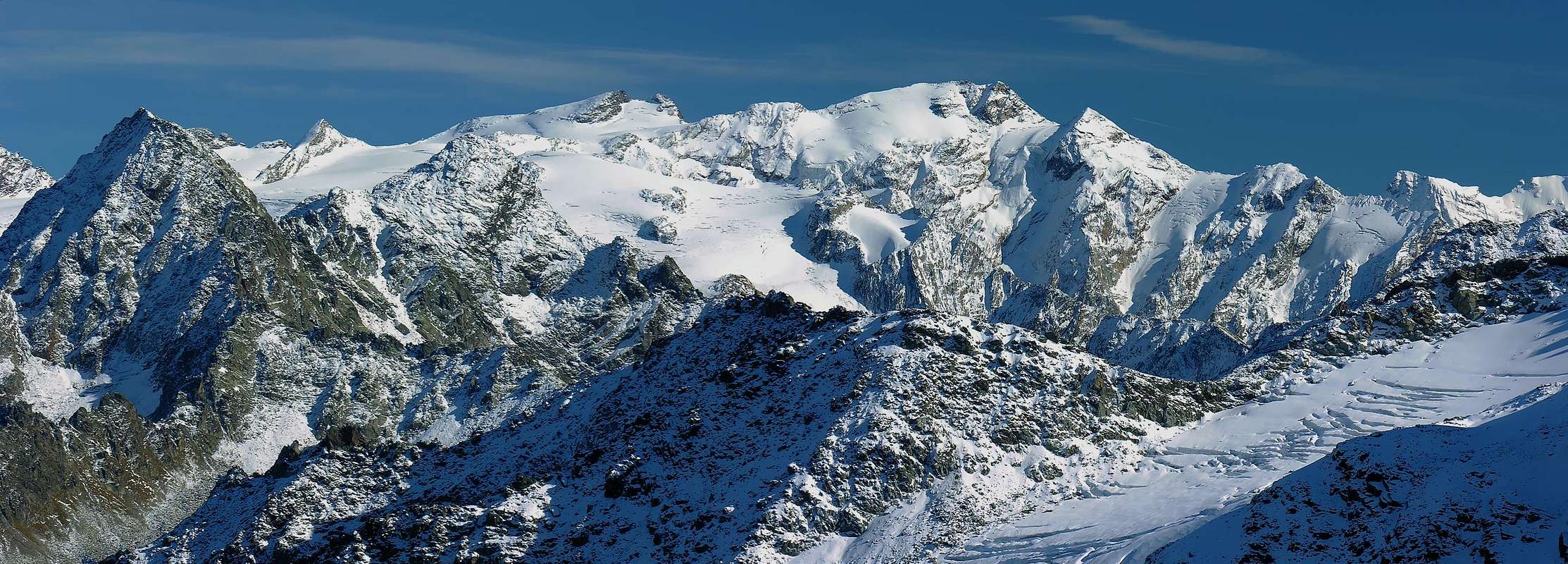
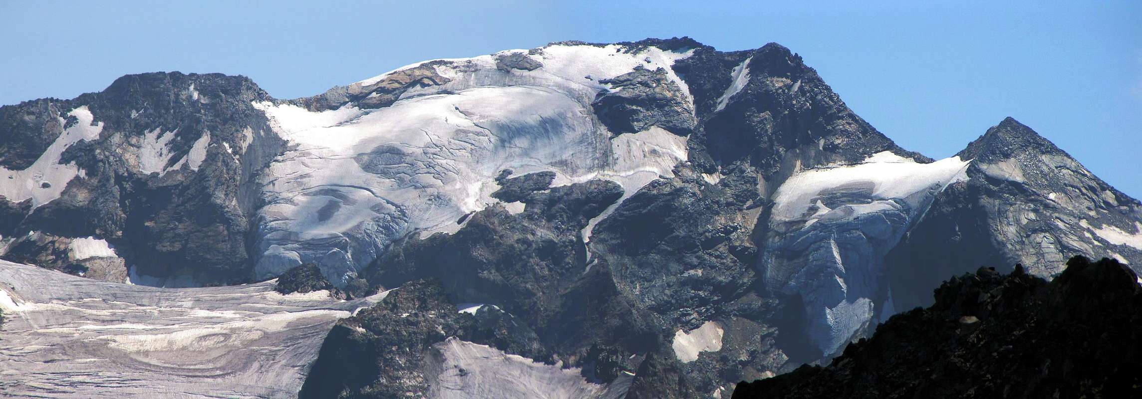
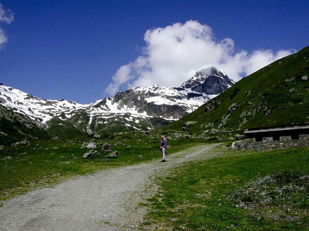
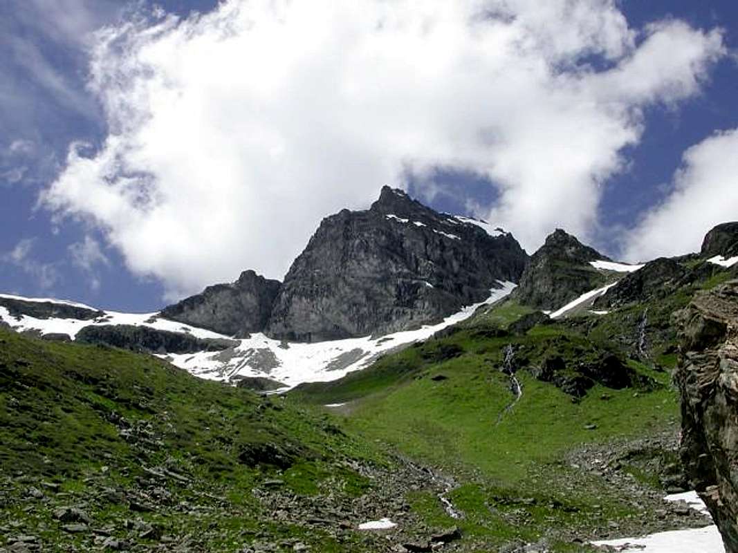
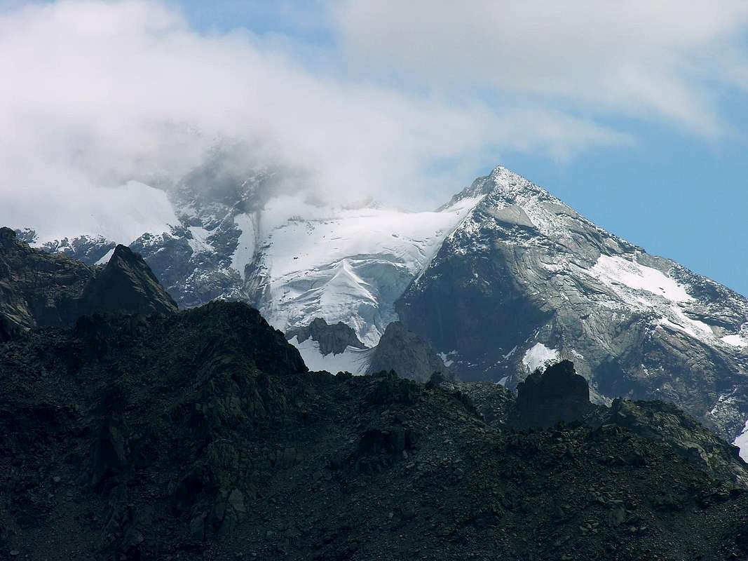
Big mountains, glacial on the North Slope to the Southern limit of the Ruitor or Rutor Glacier and rocky on the opposite side above San Grato Lake and the eponymous Walloon, rises about one Kilometer and a half to the West of the Testa (Head) del Rutor (3.486m), highest peak of the Group and the highest elevation on the crest of the border after the Grande Sassière (3.751m). Important node with the topographic crest of the border that splits by sending a branch to the North -northeast suitable to separate the Valley of La Thuile (West) from that of Valgrisenche and ending in the subgroup of Mont Paramont (3.301m), the second one proceeds more towards the Northwest to the Grand Assaly (3.174m) to finish at the Col de la Seigne (2.514m), where it takes the start of the Mountain Chain of Mount Blanc. Certainly less known Rutor, as well as popular, being more "secluded" to the West, separated from the same by the San Grato Pass (3.285m) and therefore less visible to the masses. To the North has a beautiful wall of ice nearly 500 meters tall with a large serac hanging, climbing only once in 1937. Not difficul ascent, however, requires careful while crossing the upper part of the Rutor Glacier, because the presence of numerous crevasses generally arranged along the transverse axis of the same. The routes from the South are seldom frequented by the fragility of the rock and also the danger of falling rocks or on the ice, are therefore even less, if not all, popular and "haunted". Nevertheless, part of mountaineering history and exploration on this mountain, history that begins later than the mountains of the district that is the end of 1800 and briefly runs out, for this purpose we recommend the climb to the Ridge South-southwest border, starting from Pass of the Sachère, because at least dangerous and exposed from the above mentioned. Nice view of the Glaciers Rutor and West Mont Pourrì and the peaks of the Val d'Isère-Tarenteise.
Grande montagna, glaciale sul Versante Settentrionale al limite Meridionale del Ghiacciaio del Rutor e rocciosa dal lato opposto sopra il Lago di San Grato e l'omonimo Vallone, si eleva a circa 1 Kilometro e mezzo ad Occidente della Testa del Rutor (3.486 m), punta più elevata del Gruppo e massima elevazione sulla cresta di confine dopo la Grande Sassière (3.751 m). Importante nodo topografico con la cresta di confine sdoppiantesi inviando un ramo verso Nord-nordest atto a separare la Valle di La Thuile (Ovest) da quella di Valgrisenche e che termina nel Sottogruppo del Mont Paramont (3.301 m); il secondo invece procede maggiormente verso Nordovest verso la Grande Assaly (3.174 m) per terminare al Col de la Seigne (2.514 m), ove prende inizio la Catena del Monte Bianco. Sicuramente meno conosciuta del Rutor, nonché frequentata, essendo più "appartata" verso Ovest, separata dal medesimo dal Colle di San Grato (3.285 m) e quindi meno in vista per la massa. A Nord presenta una bella parete glaciale di quasi 500 metri di altezza con un grande seracco sospeso, salita un'unica volta nel 1937. Di non difficile salita, richiede però attenzione nell'attraversamento della parte superiore del Ghiacciaio del Rutor, causa la presenza di numerosi crepacci in genere disposti lungo l'asse trasversale del medesimo. Le vie da Sud sono invece raramente frequentate per la fragilità della roccia ed anche per la pericolosità relativa a caduta di pietre oppure ghiaccio; risultano di conseguenza ancora di meno, se non addirittura del tutto, frequentate e popolari. Ciononostante fanno parte della storia alpinistica e di esplorazione su questa montagna, storia che inizia più tardi rispetto alle montagne del circondario cioè sul finire del 1800 e brevemente si esaurisce; all'uopo segnaliamo la salita per la Cresta Sud-sudovest di frontiera, partendo dal Colle della Sachère, perchè quantomeno pericolosa ed esposta a quanto sopraddetto. Belle vedute sui Ghiacciai del Rutor ed a Occidente sul Mont Pourrì e le cime della Val d'Isère-Tarenteise.
First Ascents
First on the Summit: Abbot Pierre Chanoux and Luigi Vaccarone, (Aug 22th, 1880), in ascent.
In Winter: Unknown.
N Ridge (from Becca du Lac Pass): Giovanni Bobba, Luigi Cibrario and Luigi Vaccarone, (Aug 19th, 1890), in ascent.
N Wall (from Rutor Glacier): Ettore Marcoz, Vittorio Marcoz and A. Coppa, (Sep 05th, 1937), in ascent.
E-NE Crest (to Saint Grat Pass): Osvaldo Cardellina, Marco Cossard and Giuseppe Lamazzi, (Aug 21th, 1983), in descent.
S-SW Ridge (from Sachère Pass to Loydon Arete): Lorenzo Borelli, Mario Borelli and Pompeo Viglino, (Sep 19th, 1909), in ascent.
W Crest (Arete du Loydon): Emanuele Andreis, Luigi Bon and Ettore Denina, (Aug 11th, 1927), in ascent.
Integral Traverse North/South: from Quota 3.100m-Western and Eastern Loydon-Invernet Passes-Avernet Point-Vedettes Knot-Becca du Lac Pass and Point-Saint Grat Pass; Osvaldo Cardellina, Marco Cossard and Giuseppe Lamazzi, (Aug 21th, 1983), in crossing.
Getting There
BY CAR:
From Torino, Milano, etc: Motorway A5. Exit in Morgex.
From Switzerland: through the Grand St. Bernard Tunnel or the homonym Pass.
From France: through Mont Blanc Tunnel or Petit St. Bernard Pass.
BY PLANE:
Aeroporto "Corrado Gex" Saint Christophe (Aosta).
Different Approaches from La Thuile or Valgrisenche
From Morgex to La Joux in La Thuile Valley From the Morgex exit of Motorway A5 (921m), continue for about 3 km on SS.26 Towards Pré Saint Didier (1.017m). SS.26 becomes the main street of the small city and then continues toward Colle del Piccolo San Bernardo (2.188m). After several hairpins, and past the Villages of Elevaz (1.302m) and la Balme (1.309m) reach the famous ski resort of La Thuile (1.441m). Turn left on the bridge that crosses Dora di La Thuile in the direction of the Village of La Joux. After about 2 km from the bridge, having past a large square, cross another bridge on the Dora to the right. (From this point on, the road, although paved, is quite narrow. Proceed with caution.) After 1 km get to La Joux (1.607m) and park in one of the two parking lots, which are large but sometimes fill up in August. For this reason, access past the second bridge is limited at certain times. Be there before 9 hours AM to avoid problems, or take the shuttle bus to cover the last stretch.
Da Morgex verso La Joux in Valle di La Thuile Dall'uscita dell'Autostrada A5 nel Comune di Morgex (921 m) proseguire per circa 3 km lungo la SS.26 verso il Paese di Pré Saint Didier (1.017 m), addentrarsi nella via centrale del paese e proseguire sempre lungo la Strada Statale n°26 che porta al Colle del Piccolo San Bernardo (2.188 m). Dopo numerosi tornanti e, superate le Frazioni di Elevaz (1.302 m) e la Balme (1.309 m), si giunge alla famosa località sciistica di La Thuile (1.441 m); svoltare a destra sul ponte che attraversa la Dora di La Thuile e dirigersi verso la Frazione di La Joux (1.607 m). Dopo circa 2 km e, superato un ampio piazzale, riattraversare sempre sulla destra un altro ponte sulla Dora (attenzione da questo punto la strada, seppur asfaltata, è molto stretta, procedere con cautela) e dopo circa 1 km. si giunge a La Joux (1.607 m). Qui posteggiare l'auto in uno dei due ampi parcheggi a volte insufficienti nel mese di agosto. Per questo motivo, relativamente al tratto dopo il secondo ponte, c'è una limitazione oraria all'accesso dei mezzi privati, che comunque non tocca chi arriva prima delle ore 9 AM. In alternativa esiste comunque una navetta bus.
From Leverogne Hamlet to Rognettaz Désott in Valgrisenche Valley Once, coming from SS.26, near the Village of Leverogne (780m), turn left if coming from Aosta or turn right coming from Mount Blanc (Courmayeur) or the Valley of La Thuile having crossed the Pass of the Piccolo St. Bernard, following along the Regional Route for Valgrisenche. Pass many small Villages, including Rochefort, La Ravoire, Chamençon, La Bethaz, and Valgrisenche (1.664m), the main center and Municipality of the namesake valley. Turn right for the Village of Bonne (1.810m) located near the Western border of the huge dam that forms the Beauregard Reservoir, practically empty for technical reasons of safety. Past the small Village of Menthieu (1.842m), continue for approximately 5 km along the paved road, which follows parallel to the Western shore of the lake, running high above it, and then descend leading to the old Pasture of Surier (1.758m), near the Village of Usellières (1.758m) at the southern end of the lake basin. Before the short descent to two villages stop at the village of Rognettaz Désott, from which it is possible to park. To abandon to right (Southwest) instead the dirt road "poderale" towards Arp Vieille and the Vallon with the same placename (prohibition of transit for the cars indicative and poster in wood "Arp Vieille") continuous and through the Main Road with a long and panoramic rectilinear impending the Artificial Dam or Lac de Beauregard surpassing an Alp 1.943m under the small quota 2.015 meters, the following grouping of Breyon and reaching Rognettaz-desot to quota 1.970/80 meters around. Here, he abandons contrarily, the Regional Road (poster with prohibition of transit for the automobiles); from the neighbor Pastures of Grand'Alpe (1.888m), to the entrance of the Walloon of Saint Grat continuous to through the same one, concomitant with the path n° 13/14/HRG or Tall Route Glacial and climbing side by side to the torrent to reach first the Alp of Revèraz-desot (2.153m) and immediately after alternative the 2.174 meters, where the same one finishes only continuing with the above quoted paths. Leaving on the left (West-southwest; distinctive little bridge in the shape of arch) the n° 13/HRG that it is addressed to the With of Mont (2.639m) to continue instead with the n° 14, that it goes up again the Walloon of St. Grat. Before with direction Northwest to reach the Torrent du Lac, emissary of the homonym lake and confluent of the Torrent de Grand Alpe, then with address decidedly to North on the fund of the same walloon to reach the small chapel (+; 2.466m), positioned on the Southern bank of the Loch of San Grato (+; 2.462m; 1h'45/2h'00).
Dal Borgo di Leverogne al Villaggio di Rognettaz Désott Village in ValgrisencheUna volta, arrivando dalla SS.26, nei pressi del villaggio di Leverogne (780m), girare a sinistra se si proviene da Aosta o svoltare a destra venendo dal Monte Bianco (Coumayeur) o dalla Valle di La Thuile avendo attraversato il Valico del Piccolo San Bernardo, proseguendo lungo la Strada regionale per Valgrisenche. Passare lungo molti villaggetti, tra i quali Rochefort, La Ravoire, Chamençon, La Bethaz, e Valgrisenche (1.664m), centro principale nonché sede di Comune della valle omonima. Girare a destra per il villaggio di Bonne (1.810 m) trovantesi "appollaiato" al di sopra del bordo Occidentale della grande Diga di Beauregard (in fase di chiusura poiché pericolosa e praticamente quasi vuota per questi motivi tecnici). Passato il piccolo villaggio di Menthieu (1.842 m), proseguire per circa 5 km lungo la strada asfaltata, che segue parallelamente alla stessa sponda del lago scorrendo al di sopra di esso; prima di affrontare la breve discesa conducente al vecchio pascolo di Surrier (1.758 m), nelle vicinanze del Villaggio di Usellières (1.758 m) all'estremità meridionale del bacino lacustre, fermarsi al Villaggio di Rognettaz Désott, ove si può lasciare l'auto. Qui, al contrario, si abbandona la Strada Pregionale (cartello con divieto di transito per gli automezzi); dal viciniore Grand'Alpe (1.888 m), all'imbocco del Vallone di San Grato, continuare tramite la medesima, concomitante con il sentiero n° 13/14/HRG o Alta Via Glaciale e, salendo in parallelo al torrente, raggiungere prima l'Alpe di Revèraz-desot (2.153 m) e subito dopo il bivio (2.174 m), dove la medesima termina continuando solamente con i sopracitati sentieri. Lasciando sulla sinistra (Ovest-sudovest; caratteristico ponte ad ad arco sul torrente) il n° 13/HRG indirizzantesi al Col du Mont (2.639 m) continuare invece con il n° 14 che risale il Vallone di San Grato. Prima con direzione Nordovest raggiungere il Torrent du Lac, emissario dell'omonimo lago e confluente del Torrent de Grand Alpe, poi con svolta decisamente a Settentrione sul fondo del vallone medesimo raggiungere la piccola cappella (+; 2.466 m), posizionata sulla sponda Meridionale del Lago di San Grato (2.462 m; 1h'45/2h'00).
Routes from La Thuile and Valgrisanche
From La Joux (1.607m) in La Thuile Valley towards Waterfalls and Lochs to & over Deffeyes Shelter
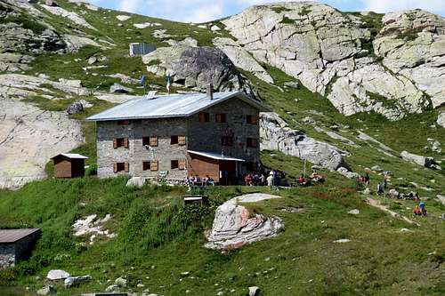
Route A: from La Joux, Albert Deffeyes Refuge and Ru(i)tor GlaciersFirst day The ascent for Rifugio Albert Deffeyes starts in front of "Bar Delle Cascate" on trail n° 3. Pass a wooden bridge on the left and after about 15 minutes you'll come to the first of the three spectacular Rutor Falls. Continue along the trail and leave Alpeggio di Parchet (1.772m) to your right. The trail continues up large steps and in a bit less than one hour passes by the second waterfall, which is not visible from the trail, but is marked by a sign (0h'55). After another 15 minutes you'll reach the sign for the the third waterfall. Continue on the steep trail for another 20 minutes to an alternative. Take the well-marked left branch that leads to the hut. (The right branch, numbered 8, leads to the beautiful Lakes of Bella Comba.) Climb to the small Col (2.130m) and then descend bending slightly to the right until Lago Glacier (2.143m). Cross the small wooden bridge over the lake outlet and, leaving Alpeggio Glacier to your right, climb steeply along wide hairpins to the plateau where Rifugio Albert Deffeyes is located at 2.494m This is a good place to spend the night (2h'45/3h'00 from La Joux).
Via A: da La Joux, Rifugio Albert Deffeyes ed attraverso i Ghiacciai del Ru(i)torPrimo giornoIniziare la salita verso il Rifugio Albert Deffeyes sul sentiero davanti al "Bar delle Cascate" contrassegnato con il n° 3, dopo aver oltrepassato un ponte in legno sulla sinistra e dopo circa (0h'15) si incontra la prima del tre spettacolari Cascate del Rutor; proseguire lungo il sentiero e oltrepassare (sulla destra) l'Alpeggio di Parchet posto sulla destra (1.772 m). Continuare sempre lungo il sentiero che ora si inerpica a gradoni e dopo circa (0h'55) si oltrepassa la seconda cascata (segnalata da un cartello e non visibile dal sentiero principale). Dopo circa altri (0h'15) si incontra il cartello della terza cascata. Continuare sul ripido sentiero per altri (0h'20). Qui il sentiero si divide: prendere quello sulla sinistra ben segnalato che conduce al rifugio (quello di destra recante il n° 8 porta ai magnifici Laghi di Bella Comba). Risalire sino al Colletto (2.130 m) per poi scendere leggermente sulla destra e proseguire fino al Lago Glacier (2.143 m); oltrepassare il ponticello in legno che sovrasta l'emissario del lago e, lasciando sulla destra l'omonimo alpeggio, riprendere a salire decisamente lungo ampi tornanti fino a raggiungere l'altipiano, dove è sito il Rifugio Albert Deffeyes (2.494 m), ove conviene pernottare (2h'45/3h'00 da La Joux).
Northern Slopes on La Thuile Valley
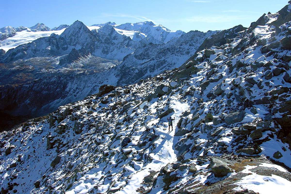
Second Day Descend for about 50m the trail n° 16 (towards Planaval Pass) for the inlet stream of Lago Azzurro. Cross the small wooden bridge and keep the right trail that leads to the Upper Rutor Lakes (2.539m). After about 10 minutes the trail forks. Keep left and reach shorlty after a small lake known by the names of "Dans la Roche" or "Lac Sans Nom" (2.602m). Continue up to a small saddle at approximately 2.670/80m and on to the left moraine of the huge Rutor Glacier. (Here at about 2.790/2.800 meters iyou'll find fixed ropes that have been recently placed after the moraine slid on the glacier. This is perhaps the most difficult spot of the entire ascent.) Past this point, leave on your left the secondary Ussellettes Walloon that leads to Planaval Pass (3.016m). Go on ascending up to the left ramification of the glacier, just above the Flambeau (3.315m). Follow up to near the Chatêau Blanc Pass then cross toward West-southwest the higher plain of the Rutor Glacier (warning to the many crevasses) getting the Noeud (Knot) of the Vedettes (3.285m), also more directlyin Southwest to Becca du Lac Pass (3.336m). Along a snow slope fairly steep (37°/40°; frames generally to East) and the rotten rocks of the North Crest, in less than 80 meters easily you get the Summit, formed by gneiss great blocks (4h'45/5h'00). Descent: along the same route.
Secondo giornoScendere per circa 50 metri il sentiero n° 16 (per il Passo di Planaval) che porta all'immissario del Lago Azzurro; attraversare il piccolo ponte in legno e portarsi sul sentiero di destra adducente ai Laghi Superiori del Rutor (2.539 m). Dopo circa (0h'10) il sentiero si divide, continuare su quello si sinistra. Poco dopo si costeggerà un laghetto conosciuto come Dans la Roche o "Lac Sans Nom" (2.602 m). Salire sino alla piccola sella posta a circa (2.670/80 m); continuare sul sentiero fino a raggiungere la morena sinistra dell'enorme Ghiacciaio del Rutor (attenzione: qui a quota 2.790/2.800 m~. circa si incontra un passaggio da superare con corde fisse a causa del recente franamento della morena sul ghiacciaio, forse il punto più difficile dell'intera salita). Oltrepassato questo punto, si lascia sulla sinistra il secondario Vallone di Ussellettes che porta al Colle di Planaval (3.016 m). Proseguire la salita fino a raggiungere la branca di sinistra del ghiacciaio posta subito sotto il Flambeau (3.315 m). Continuare la salita e, giunti nei pressi del Colle di Chatêau Blanc, attraversare verso Ovest-sudovest il pianoro superiore del Ghiacciaio del Rutor (attenzione la zona è alquanto crepacciata) arrivando al Nodo delle Vedette (3.285 m), oppure più direttamente verso Sudovest al Colle della Becca du Lac (3.336 m). Per un pendio nevoso abbastanza ripido (37°/40°; cornici in genere verso Est) e per la cresta Nord di rocce rotte, in meno di 70 metri, facilmente si raggiunge la Vetta, formata da alcuni blocchi di gneiss (4h'45/5h'00). Discesa: per la stessa via di salita.
Southern Slopes on Valgrisenche
Route B: from St. Grat Lake towards Sachère Pass and through South-southwestern Ridge All the via from the South, the overlying Lake Saint Grat, are dangerous because of the fragility of the rock with the possibility of falling stones and also ice, then discard a priori the climb up the Southeast Face and also the route from the South to the Saint Grat Pass, we prefer to indicate why the Southern rocky Slope an ascent through the Ridge South-southwest, starting from the Col of the Sachère (2.855m). From this to follow a trace for brief time with direction West-northwest through grassy slant reaching quota 2.559/70 meters around, then to mostly continue toward Northwest through deposits, debris and shed blocks that conduct to the basal moraine of the rests of the Glacier de la Sachère around the 2.750/800 meters of quota, near the effluent small torrent, and to go up again easily along the same up to the Glacier and the Hill of the Sachère, through a small diagonal slope from the right to the left (2.841m; 1h'00; in total 3h'00 from the departure). From the hill to go himself toward North and to climb the not always easy Southern Ridge to Quota 3.172 meters, at the margin of the Eastern Arete of Loydon, and then Southwest to the Summit, climb up to the first part of this conjunction by means of fairly steep rocks, but with many footholds and by half a dozen ledges interspersed obvious. From this point go up with the Northeast direction passing first a tract almost always with snow up to a small brownish tower (* surmountable through a chimney rock of III°, getting off at the next carving through broken rocks not difficult); continue on the ridge of rocks not far steep (it is possible to find snow) up to a red wall of a dozen meters below the Summit. Go around to the East by a ledge, then climb up to 6 meters, beyond a small edge, through a slit most sensitive to the instability of the rock hard (III°-) and to the rocks easier, but still steep, it reaches the Top (1h'45/2h'00 from Sachère Pass; 4h'30/5h'00 in total).
Via B: dal Lago di San Grato attraverso il Colle della Sachère e per la Cresta Sud-sudovestTutte le vie da Sud, soprastanti il Lago di San Grato, son pericolose a causa della fragilità della roccia con la possibilità di cadute di pietre ed anche di ghiaccio; scartando quindi aprioristicamente le salite sulla Faccia Sudest ed anche l'itinerario da Sud verso il Colle di San Grato, preferiamo indicare per questo roccioso Versante Meridionale l'ascensione tramite la Cresta Sud-sudovest, partendo dal Colle della Sachère (2.855 m). Da questo seguire per breve una traccia con direzione Ovest-nordovest attraverso pendii erbosi e raggiungendo quota 2.559/70 m~; poi continuare maggiormente verso Nordovest tramite detriti e blocchi sparsi che conducono alla morena basale dei resti del Glacier de la Sachère intorno ai 2.750/800 m di quota, presso il torrentello emissario, per risalire facilmente affiancandolo fino al Glacier ed al Colle de la Sachère, per mezzo di una piccola salita diagonale dalla destra alla sinistra (2.841 m; 1h'00; in totale 3h'00 dalla partenza). Dal colle dirigersi verso Settentrione e salire la non sempre facile Cresta Sud fino alla Quota 3.172 m, al margine Orientale della Arete de Loydon, e quindi Sudovest fino alla Cima; rimontare la prima parte fino a questa congiunzione per mezzo di rocce abbastanza ripide, ma con molti appigli ed intervallate da una mezza dozzina di evidenti cenge. Da questo punto continuare a salire con direzione Nordest superando dapprima un tratto quasi sempre con neve fino ad un torrioncino brunastro (* superabile tramite un camino roccioso di III°, scendendo al successivo intaglio tramite blocchi spaccati non difficili); proseguire sul filo di cresta su rocce non molto ripide (possibilità di trovare neve) fino ad un muro rosso di una dozzina di metri sottostante la Sommità. Aggirarlo ad Est tramite una cengia di 6 metri circa quindi risalire, al di là di uno spigoletto, tramite una fessura più delicata per l'instabilità della roccia che difficile (III°-); per rocce più facili, ma ancor ripide, si raggiunge la Vetta (1h'45/2h'00 dal Colle della Sachère; 4h'30/5h'00 in totale).
Difficulty
The routes is considered: by PD- to PD (A) and from PD to PD+ (B); in each case the same depend on the conditions of the mountain.
Gli itinerari sono considerati da PD- a PD (A) e da PD a PD+ (B); in ogni caso i medesimi dipendono dalle condizioni della montagna.
Equipment
Mountaineering equipment including rope, ice axe, and crampons.
Parents refers to a larger category under which an object falls. For example, theAconcagua mountain page has the 'Aconcagua Group' and the 'Seven Summits' asparents and is a parent itself to many routes, photos, and Trip Reports.

 7222 Hits
 85.75% Score
 21 Votes