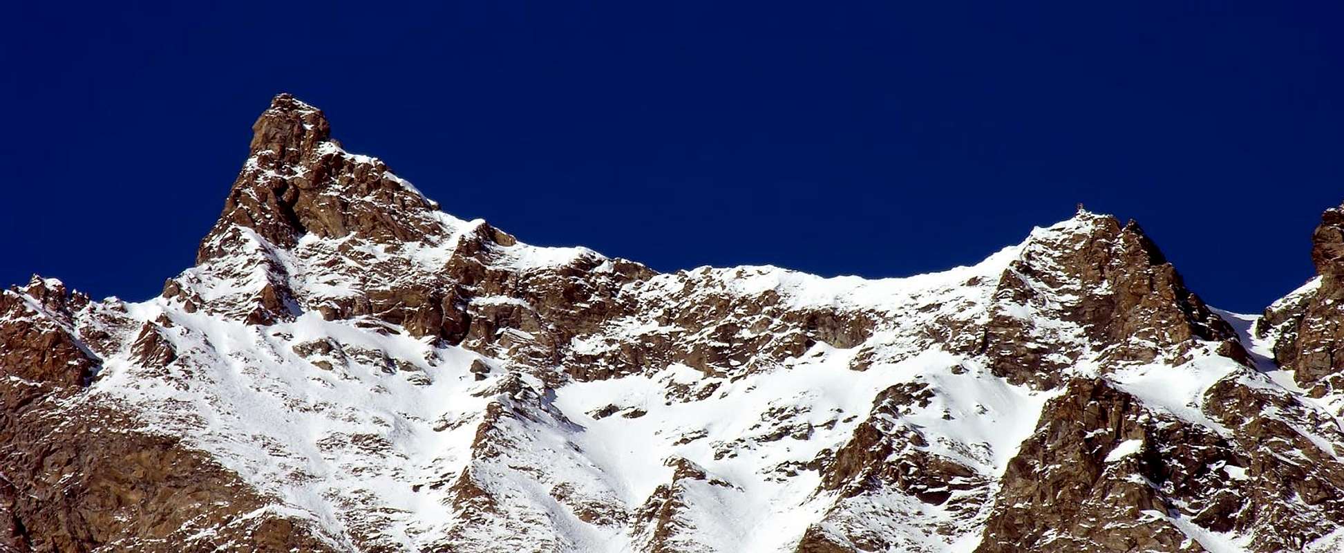
They say that when seen from its eastern side it looks like a big eagle with its wings folded out upon the head, on the opposite side looks like a small wedge supporting the NE side of the small Luetta Glacier. The summital ridge, coming from the Punta di Feluma toward SW, after the summit goes to N-NE dropping for about 100m over the omonymous pass (3.082m) then grows up to Quota (3.275m) and to the Becca di Tos (3.301m).
Montagna "double face" di aspetto. Infatti, se vista dal versante orientale, appare quale grande aquila con le ali dispiegate sulla testa dalla quale svetta la sommità aguzza; su quello opposto invece appare quale piccolo cuneo, atto a sorreggere il margine nord-orientale del piccolo Ghiacciaio di Luetta. La cresta sommitale, proveniente dalla Punta di Feluma con andamento SW, la lega a questa montagna; dopo la vetta prosegue con direzione N-NE cadendo per poco più di un centinaio di metri sull'omonimo colle (3.082 m), per poi rialzarsi alla Quota (3.275 m) ed alla Becca di Tos (3.301 m).
First Ascents
First on the summit (from W ridge): Giovanni Bobba and Casimiro Thérisod, (Jul 14th, 1891).
In winter: Unknown.
W Ridge: Giovanni Bobba and Casimiro Thérisod, (Jul 14th, 1891).
N Arête: Giovanni Bobba and Casimiro Thérisod, (Jul 14th, 1891), in descent.
From Torino, Milano, etc: Motorway A5. Exit at Aosta Ovest.
From Switzerland: through the Grand Saint Bernard Tunnel or the namesake Pass.
From France: through the Mont Blanc Tunnel or Petit Saint Bernard Pass: It is not necessary to take Motorway A5: you can drive on SS.26, in the direction of Leverogne.
BY PLANE:
Aeroporto "Corrado Gex" Saint Christophe (Aosta).
Route
From Aosta along the SS.26 till near Leverogne, here you have to turn into the Regional Road of Valgrisenche and, after passing Rochefort, La Ravoire, Prariond, Cére e La Béthaz, cross the bridge on the left before the tunnel to get Plantè Village (1.656m). At the first hairpin bend start along the muletrack in the wood (Alta Via n° 2) and, crossing Verconey Desot and Damont (1.980m), follow the forestal road to Maison Forte(2.365m); walk along the bottom of the valley along the stream (Torrent de Luetta) up to a small lake (2.900m) at the beginning of the morain of the Luetta Glacier. Trough a small notch (marks of the glacier) and a wide ledge toward E-SE to get the pass between the Punta di Luetta and the Punta di Feluma, last 50 metres are on gravel. Along the S-SW side and the SW ridge on low marked tracks you must turn to the left a greenish rock then go to the right (variant along the ridge, very exposed, on bad quality rock) and cross to the N side of the ridge up to a chimney with a fitted block of rock (II° UIAA). Toward South (great exposure), on often wet rocks (III°+ UIAA), to get the slanted slab of the summit (3h'30/4h'30). Careful with snow or ice. Descent: From the same route.
Dalla Città di Aosta (583 m) si percorre la SS.26 per il Monte Bianco e, giunti nei pressi dell'abitato di Leverogne (780 m), si imbocca sulla sinistra la Strada Regionale per la Valgrisenche. Dopo aver superato le Frazioni di: Rochefort, La Ravoire, Prariond, Cére e La Béthaz superare il ponte sulla sinistra prima del tunnel e raggiungere il villaggio di Planté (1.656 m). Al primo tornante prendere la mulattiera del bosco (Alta Via n° 2) e passando per Verconey Desot e Damont (1.980 m), ove arriva anche l'interpoderale da Frassy (1.658 m), per la strada forestale si giunge a Maison Forte (ruderi) e all'omonima alpe (2.365 m); proseguire sul fondo del vallone lungo il "Torrent de Luetta" raggiungendo un laghetto (2.900 m~), che precede la morena dell'omonimo ghiacciaio. Per una piccola giogaia (misurazioni del Ghiacciaio di Luetta a quota 2.980 m del 1989, scritte in rosso) e per banconate verso E-SE si giunge al colletto tra la Punta di Luetta e la Punta di Feluma superando gli ultimi 50 metri su ghiaia fine. Per il versante S-SW e la cresta SW, su tracce scarse, si aggira un roccione verdastro a sinistra per portarsi poi a destra (si può percorrere il filo di cresta sino all'intaglio di 4/5 metri su rocce micascistiche in sfacelo e con grande esposizione ad est) ed infine traversare a nord della cresta sino ad un camino con blocco di circa 2 metri incastrato (II°). Continuare con esposizione a sud su rocce non buone spesso umide o addirittura bagnate (III°+); raggiungere la vetta formata da una placca scivolante a SE (3h'30/4h'30). Salita delicata con neve e verglass. Discesa: Lunga la stassa via di salita.
Difficulties
PD+/AD-; passages of II°, III°+ and more on the ridge edge.
Da PD+ a AD-; II°, II°+ III°+ e oltre se sul filo di cresta.
Equipment
High mountain gear : rope, iceaxe, crampons, helmet.
Da alta montagna: corda, piccozza, ramponi e casco.
Campings
Remember that free camping is forbidden (except for emergency reasons, over 2.500m, from darkness until dawn).
Mountain Condition
You can get meteo information at the official site of the Regione Valle d'Aosta:
A.I.NE.VA. (Associazione Interregionale Neve e Valanghe).
Useful numbers
Protezione Civile Valdostana località Aeroporto n° 7/A Saint Christophe (Ao) Tel. 0165-238222.
Bollettino Meteo (weather info) Tel. 0165-44113.
Unità Operativa di Soccorso Sanitario Tel. 118.
Acknowledgements
I am greatly indebted to my friend "Osva" for the detailed description of the route. In addition I want to thank Gabriele Roth for the translation of the text from italian.
Parents refers to a larger category under which an object falls. For example, theAconcagua mountain page has the 'Aconcagua Group' and the 'Seven Summits' asparents and is a parent itself to many routes, photos, and Trip Reports.

 8118 Hits
 92.32% Score
 38 Votes