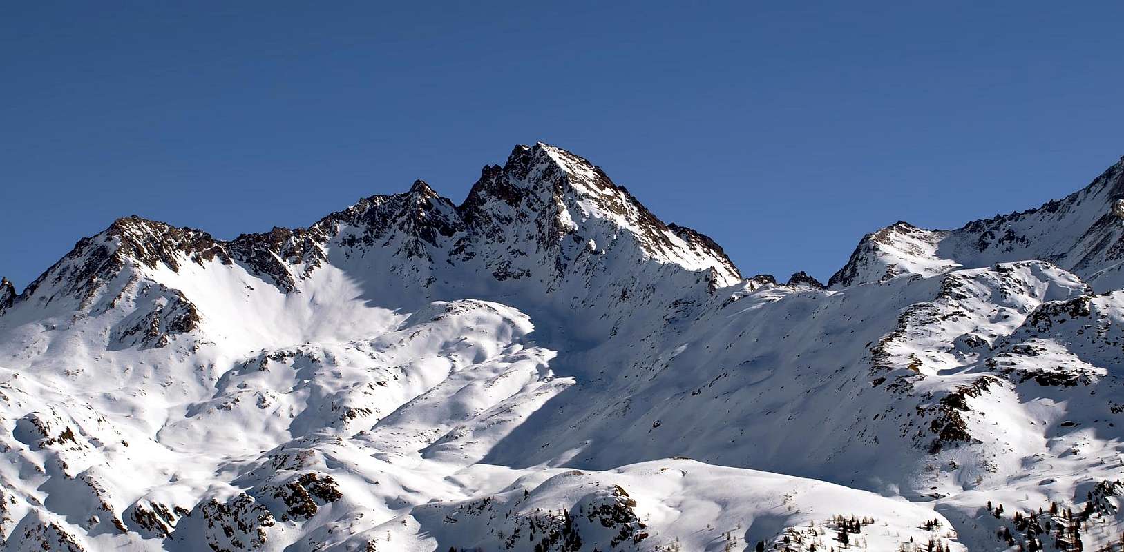
This mountain is a regulat pyramid with four walls and four ridges, it is the sequel of the ridge coming from Becca d'Invergnan or Grande Rousse, that after the Punta di Rabuigne and the Cima del Bouc, goes down to the Colle Finestra (2.840m). Here starts the S ridge of the Becca di Tei that, after the summit, goes down to the Colle di Cussuna (2.896m). The other two ridges go down toward Rhemes Notre Dame, the Eastern one dividing the Cussuna and Torrent Valleys; the Western one down to the Truc de la Seja (2.554m), above the Artificial Lake of Beauregard, near the Refuge Chalet de l'Epeé (2.377m).
Piramide regolare a quattro creste e quattro pareti. Costituisce la continuazione della cresta proveniente dalla Becca d'Invergnan o Grande Rousse, che, dopo aver formato la Punta di Rabuigne e la Cima del Bouc, decade al Colle Finestra (2.840 m). Qui si diparte la cresta Sud della Becca di Tei che, oltre la vetta, precipita verso NE sul sottostante Colle di Cussuna (2.896 m). Le altre due creste scendono verso Rhêmes Notre Dames: la Est a separare i Valloni di Cussuna e di Torrent; la cresta Ovest degrada invece allungandosi sino al Truc de la Seja (2.554 m), a dominare il Lago Artificiale di Beauregard, a poca distanza dal Rifugio Chalet de l'Epeé (2.377 m).
First Ascents
First on the summit: Unknown.
In winter: Unknown.
W Arête: G. B. Bozzino and Sister, (Jul 08th,1910).
N-W Wall: Piero Bethaz and Giulio Bovard, (Jul 22th, 1983).
E Arête and S-E Wall: P. F Quaini and friend, (Jul 15th,1914).
S Arête and S-E Wall: Lorenzo and Mario Borelli, (Sep 20th,1909).
Getting There
BY CAR:
From Torino, Milano, etc: Motorway A5. Exit at Aosta Ovest.
From Switzerland: through the Grand Saint Bernard Tunnel or the namesake Pass.
From France: through the Mont Blanc Tunnel or Petit Saint Bernard Pass: It is not necessary to take Motorway A5: you can drive on SS.26, in the direction of Leverogne.
BY PLANE:
Aeroporto "Corrado Gex" Saint Christophe (Aosta).
Itinerary
From the City of Aosta (583m) follow SS.26 toward Mont Blanc. Once close to the Village of Leverogne (780m), turn left on the Regional Route for Valgrisenche. Pass many small Villages, including Rochefort, La Ravoire, Chamencon, La Bethaz, and the town of Valgrisenche. Turn right for the Village of Bonne (1.810m) located near the huge dam that forms the Beauregard Reservoir. Past the small Village of Menthieu (1.842m), continue for approximately 5 km along the paved road, which follows the shore and leads to the old Pasture of Surier (1.758m), near the Village of Usellières (1.758m).
Dalla Città di Aosta (583 m) si percorre la SS.26 per il Monte Bianco e, giunti nei pressi dell'abitato di Leverogne (780 m), si imbocca sulla sinistra la Strada Regionale per la Valgrisenche, dopo aver superato le Frazioni di: Rochefort, La Ravoire, Chamencon, La Bethaz ecc. Dopo aver superato il capoluogo di Valgrisenche, proseguire sulla destra per la Frazione di Bonne (1.810 m) situata proprio di fianco all'enorme sbarramento artificiale che racchiude il Lago di Beauregard. Superato il piccolo Villaggio di Menthieu (1.842 m), si prosegue per circa 5 km lungo la strada asfaltata che costeggio il lago e che porta al vecchio Alpeggio di Surier (1.758 m), vicino al Villaggio di Usellières (1.758 m).
Route
From the car parking of Usellières (1.758m), up to dirt road near the Alpe di Arolla (1.921m) the, toward NE to the Nouva (2.135m) and the Epeé (2.345m) Pastures and the nearby refuge (2.377m). Boarding to the N the Bouque stream go on along the Alta Via n° 2 path, beyond the Lake (2.604m) leaving to the right the path to Fenêtre du Torrent (2.840m). On, along the scree, till the West ridge on the right of two rocky projections (2.800m~), along the ridge, steep and made of broken rocks. At the end the ridge becomes easier and on scree you get the summit (3h'00/3h'30). Down along the same route.
Da Usellières (1.758 m), risalire dal parcheggio alla soprastante strada poderale presso l'Alpe di Arolla (1.921 m) e da questa raggiungere verso NE le successive di Nouva (2.135 m) e di l'Epeé (2.345 m) ed il vicino omonimo rifugio (2.377 m). Da questi, costeggiando a nord il Torrent de Bouque, risalire sul sentiero dell'Alta Via n° 2 l'omonimo vallone, doppiando il Laghetto (2.604 m) e lasciando a destra il sentiero per la Fenêtre du Torrent (2.840 m). Risalire la pietraia che porta sulla cresta Ovest lasciando sulla sinistra due spuntoni (2.800 m~); continuare a salire la cresta su rocce rotte abbastanza ripide. Nel finale la cresta diventa più facile e su sfasciumi e detriti si giunge in vetta (3h'00/3h'30). Discesa lungo la via di salita.
A.I.NE.VA. (Associazione Interregionale Neve e Valanghe).
Useful numbers
Protezione Civile Valdostana località Aeroporto n° 7/A Saint Christophe (Ao) Tel. 0165-238222.
Bollettino Meteo (weather info) Tel. 0165-44113.
Unità Operativa di Soccorso Sanitario Tel. 118.
Acknowledgements
I am greatly indebted to my friend "Osva" for the detailed description of the route. In addition I want to thank Gabriele Roth for the translation of the text from italian.
Parents refers to a larger category under which an object falls. For example, theAconcagua mountain page has the 'Aconcagua Group' and the 'Seven Summits' asparents and is a parent itself to many routes, photos, and Trip Reports.

 7567 Hits
 83.1% Score
 16 Votes