
-
 3999 Hits
-
 76.66% Score
-
 7 Votes
|
|
Mountain/Rock |
|---|---|
|
|
45.63613°N / 7.09854°E |
|
|
9596 ft / 2925 m |
|
|
Overview
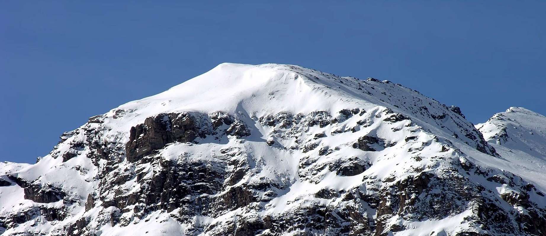
Big shoulder of debris and northwestern broken rocks the Becca di Tos toward the beginning of the Valgrisenche above the inhabited area of Revers.
Grosso spallone di detriti e rocce rotte a nord-ovest della Becca di Tos verso l'inizio della Valgrisenche sopra l'abitato di Revers.
First Ascents
- First on the summit: Unknown.
- In Winter: Unknown.
 |
Getting There
BY CAR:- From Torino, Milano, etc: Motorway A5. Exit at Aosta Ovest.
- From Switzerland: through the Grand Saint Bernard Tunnel or the namesake Pass.
- From France: through the Mont Blanc Tunnel or Petit Saint Bernard Pass: It is not necessary to take Motorway A5: you can drive on SS.26, in the direction of Leverogne.
- Aeroporto "Corrado Gex" Saint Christophe (Aosta).
Dalla città di Aosta (583 m) si percorre la SS.26 per il Monte Bianco e giunti nei pressi dell'abitato di Leverogne (780 m) si imbocca sulla sinistra strada regionale per la Valgrisenche, dopo aver superato le frazioni di: Rochefort, La Ravoire e raggiunto Chamençon voltare a sinistra verso il Villaggio di Chamin (1.399 m - parcheggio).
Route Description
From Chamin Village (1.399m), crossing the woody slopes behind the houses, you arrive to an open ground (no paths or tracks) that allows to get the slopes leading to the Tos Glacier. From the beginning of the moraine of the glacier to climb toward right (W) for big stones and debris, to go up again to the right always of a rocky rib that goes down from the top of the mountain up to reach the peak.Da Chamin (1.399 m) attraverso i pendii boscosi alle spalle del Villaggio si raggiunge un terreno più aperto (senza tracce di sentiero). Dall'inizio della morena del ghiacciaio di Tos salire verso destra (ovest) per pietraie e sfasciumi, risalire sempre a destra di una costola rocciosa che scende dalla cima della montagna fino a raggiungere la vetta.
Difficulty
The route can be classified as EE.L'itinerario è classificato EE.
 |
 |
 |
 |
 |
Campings
Remember that free camping is forbidden (except for emergency reasons, over 2.500m, from darkness until dawn).Essential Gear
Standard mountaineering equipment.Da escursionismo.
MAPS:
Mountain Condition
- Meteo: you can find all the needed informations at the official site of the Valle d'Aosta Region:
- Valle d'Aosta Meteo
Webcam
- WEBCAM on Aosta Valley:
- Webcam
Books and Maps
BOOKS:- "Guida delle Alpi Occidentali" di Giovanni Bobba e Luigi Vaccarone C.A.I. Sezione di Torino Volume II (parte II), 25 Maggio 1896.
- "Guida dei Monti d'Italia–Alpi Graie Centrali" di Alessandro Giorgetta - Club Alpino Italiano/Touring Club Italiano, 1985 (in Italian).
- "Diari Alpinistici" di Osvaldo Cardellina e Indice Generale accompagnato da Schedario Relazioni Ascensioni 1964-2019 (inediti).
 |
 |
 |
- Kompass "Gran Paradiso Valle d'Aosta Sentieri e Rifugi" Carta turistica 1:50.000.
- L'Escursionista "Valgrisenche Val di Rhêmes" Carta dei Sentieri" (carta n° 3) 1:25.000.
- I.G.C. Istituto Geografico Centrale "Parco Nazionale del Gran Paradiso" (carta n° 3) 1:50.000.
- Enrico Editore Ivrea-Aosta "Gruppo del Gran Paradiso" 1:50.000.
Important Information
- REGIONE AUTONOMA VALLE D'AOSTA the official site.
- FONDAZIONE MONTAGNA SICURA Villa Cameron, località Villard de la Palud n° 1 Courmayeur (AO) Tel: 39 0165 897602 - Fax: 39 0165 897647.
- SOCIETA' DELLE GUIDE DI VALGRISENCHE.
- COMPAGNIE DES GUIDES RUTOR Fraz. Entrèves tel/fax 0039.0165.885574 e-mail Guidealpine@lathuile.it
- A.I.NE.VA. (Associazione Interregionale Neve e Valanghe).
Useful numbers
- Protezione Civile Valdostana località Aeroporto n° 7/A Saint Christophe (Ao) Tel. 0165-238222.
- Bollettino Meteo (weather info) Tel. 0165-44113.
- Unità Operativa di Soccorso Sanitario Tel. 118.