
-
 2660 Hits
-
 81.84% Score
-
 14 Votes
|
|
Mountain/Rock |
|---|---|
|
|
45.72589°N / 6.87835°E |
|
|
Mountaineering |
|
|
Summer |
|
|
8947 ft / 2727 m |
|
|
Overview
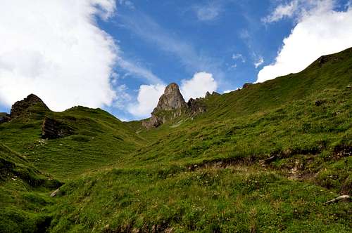
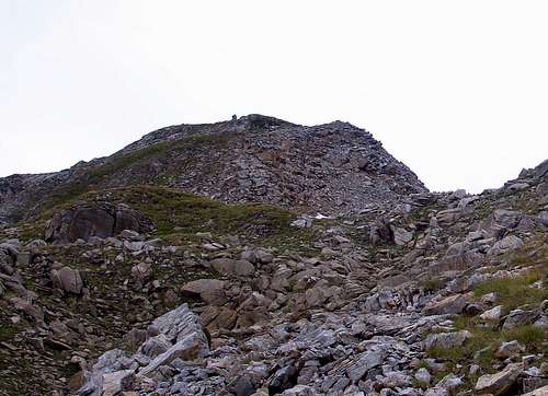
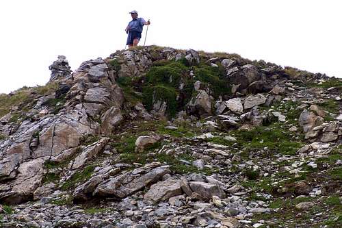
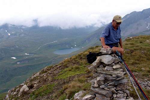
This small but distinct Summit is located South of the internal buttress that, in the Valley of the Piccolo St. Bernard, the Vallon Chavannes separates the East from that of Breuil on the other side. Starting from the inside respect the two vallons Bassa Serra (Lower; 2.836m) in fact originates a ridge to the East, after the Col des Echelles des Chavannes or Western Low Serra (2.737m; important remains of fortifications), reaches the Pointe du Fornet (3.070m). From this partition, flexing more to Southeast arrives first at Mont Ouille (3.098m), the highest elevation of this small Subgroup, to end with the Mont Laityre, or locally simply Laityre, which slopes down to the main road of the Piccolo St. Bernard. In practice it is formed from a single side round that unfolds from East over the Torrent de Chavannes to the South on Doire du Verney and ends in the West with the Grand Berrier (Great Shepherd, 2.464m), large and distinctive appearance from the rocky gendarme shaped as Dolomite mountains above the Torrent du Breuil. Easy and fun to climb, it presents various options starting with excellent trails at the Southeast Arpettes Alp (1.760m) or to the Southwest from the Plan-Veyle or Veylé Alpages (2.080m); also numerous secondary paths connecting depart from Pastures Chaz Pontaille and Chanté at the National Road towards the Little Saint Bernard Pass and Tarentaise (France). Unusual views towards the Lac du Verney (2.088m) and the Piccolo San Bernardo and the valley of the same name to La Thuile while, frontally but in the distance, unfold the great glaciers of Rutor from the Testa (Head) del Rutor towards La Thuile Resort.
Questa piccola ma ben distinta Sommità é situata a Sud del contrafforte interno che, nel Vallone del Piccolo San Bernardo, separa il Vallone di Chavannes ad Oriente da quello del Breuil sul versante opposto. Partendo dalla interna ai due valloni Bassa Serra (2.836 m) infatti si origina verso Est una cresta che, dopo il Col des Echelles des Chavannes od Occidentale di Bassa Serra (2.737 m; resti importanti di fortificazioni), raggiunge la Pointe du Fornet (3.070 m). Da questa il divisorio, flettendo maggiormente a Sudest perviene dapprima al Monte Ouille (3.098 m), massima elevazione di questo piccolo Sottogruppo, per poi terminare con il Mont Laityre, od in loco semplicemente Laityre, che declina verso la Strada Statale del Piccolo San Bernardo. In pratica risulta formato da un'unico versante tondeggiante che si dispiega da Est sopra il Torrent de Chavannes verso Mezzogiorno sulla Doire du Verney per concludersi ad Occidente con il Grand Berrier (Grande Pastore; 2.464 m), grosso nonché caratteristico gendarme roccioso dall'aspetto Dolomitico soprastante il Torrent du Breuil. Facile e divertente ascensione, presenta diverse possibilità di partenza con ottimi sentieri da Sudest presso l'Alpe di Arpettes (1.760 m) o da Sudovest da quella di Plan-Veyle o Veylé (2.080 m); inoltre numerosi sentieri secondari di collegamento partono dagli Alpeggi di Chaz Pontaille e Chanté presso la Strada Statale. Vedute inusuali verso il Lac du Verney (2.088 m) ed il Colle del Piccolo San Bernardo e sull'omonimo vallone fino a La Thuile mentre, frontalmente ma più in lontananza, si dispiegano i grandi ghiacciai del Rutor dalla Testa del Rutor in direzione del Comprensorio di La Thuile.
First Ascents
- First on the summit: Unknown.
- In winter: Unknown.
 |
 |
Getting There
BY CAR:
- From TORINO, MILANO, etc: Motorway A5. Exit at IVREA or Quincinetto (PIEDMONT).
- From FRANCE: through the Mont Blanc Tunnel to Entrèves/Courmayeur. By Little Saint Bernard Pass, closed since November until half May to La Thuile Valley - Pré Saint Didier - Aosta - Verrès Municipalities. It is not necessary to take Motorway A5: you can drive on SS.26, in the direction of AOSTA - IVREA - TURIN. From the Morgex exit of Motorway A5 (921m), continue for about 3 km on SS.26 towards Pré Saint Didier (1.017m). SS.26 becomes the main street of the small city and then continues toward Colle del Piccolo San Bernardo (2.188m). After several hairpins, and past the Villages of Elevaz (1.302m) and la Balme (1.309m) reach the famous ski resort of La Thuile (1.441m). Turn left on the bridge that crosses "Dora di La Thuile", a go on along the same road continue to rise along the National Road n°26, which leads to the Piccolo San Bernardo Pass to Lake Verney (2.088m) just below the pass.
IN AUTO:
- Dall'uscita dell'Autostrada A5 nel comune di Morgex (921 m) proseguire per circa 3 km lungo la SS.26 verso il Paese di Pré Saint Didier (1.017 m), addentrarsi nella via centrale del paese e proseguire sempre lungo la Strada Statale n°26 che porta al Colle del Piccolo San Bernardo (2.188 m). Dopo numerosi tornanti e superate le Frazioni di Elevaz (1.302 m) e la Balme (1.309 m) si giunge alla famosa località sciistica di La Thuile (1.441 m). Svoltare a destra sul ponte che attraversa la "Dora di La Thuile", continuare a salire lungo la Strada Statale n°26 che conduce al Colle de Piccolo San Bernardo fino al Lago di Verney (2.088 m) sito appena sotto il colle.
BY PLANE:
- Aeroporto "Corrado Gex" Saint Christophe (Aosta).
 |
 |
Approach and Route
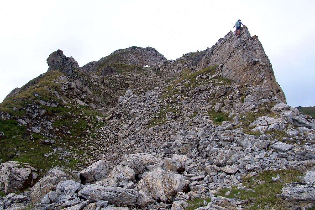
From the hairpin bend 1.861 meters with little parking on the SS.26 La Thuile to the Little St Bernard Pass (2.002m), at the Alpe La Cretaz (1.886m) in the Plan of Abundance, with West-southwest direction, route n° 10 concurrent with the farm road, toward Chaz Pontaille (1.975m) and along the wadi Verney, descend briefly to the quaint little bridge Pont (1.838m) on the Torrent du Lac, from the Lac Verney in the southwest and the Torrent Breuil in Northwest. First go back to the West towards Alpe Chanté (1.993m) and then to the West-northwest, in conjunction with the dirt farm road (short cut), towards the Alpe Plan Veyle (2.080m; source), just before taking on the right (East ) path n° 10B for Mont Laityre (2.727m). With a diagonal to the East to reach the town of Les Cotes where the path bends decisively towards the North, reaching a height of about 2.375 meters to trail n° 10 coming from Arpettes Alpage. Continue with five twists reaching the point 2.643 meters and just after the Summit (EE/F/F+; 2h'45/3h'15).
Variant: wanting to climb a little, you can leave the trail n° 10B/10 and, moving more towards the East through an easy traverse on graggy-debris fields, go to a small rocky ridge at times even enough sharp, with no set course, with amusing passages (I°/I°+) leading to the Summit (EE/F+; more or less the same time).
Dal tornante 1.861 metri con piccolo parcheggio sulla SS.26 di La Thuile per il Colle del Piccolo San Bernardo (2.002 m), presso l'Alpe La Cretaz (1.886 m) nel Piano dell'Abbondanza, con direzione Ovest-sudovest, sentiero n° 10 concomitante con la strada poderale, verso la Chaz Pontaille (1.975 m) e, lungo il Torrente Verney, scendere brevemente al piccolo e caratteristico Ponte di Pont (1.838 m) sul Torrent du Lac, proveniente dal Lac Verney a Sudovest e dal Torrent Breuil a Nordovest. Risalire prima ad Occidente verso l'Alpe Chanté (1.993 m) e poi ad Ovest-nordovest, in concomitanza con la strada interpoderale (breve scorciatoia), verso l'Alpe Plan Veyle (2.080 m; sorgente), prendendo poco prima sulla destra (Est) il sentiero n° 10B per il Mont Laityre (2.727 m). Con un diagonale verso Oriente raggiungere la località di Les Cotes dove il sentiero, piegando decisamente verso Settentrione, raggiunge a quota 2.375 metri circa quello n° 10 che proviene dall'Alpeggio di Arpettes. Continuare con cinque tornanti raggiungendo il punto 2.643 metri e subito dopo la Sommità (E/F; 2h'45/3h'15).
Variante: volendo arrampicare un pò, si può abbandonare il sentiero n° 10B/10 e, spostandosi in traversata maggiormente verso Oriente, andare verso una piccola cresta rocciosa a tratti anche abbastanza affilata che, senza percorso obbligato, con divertenti passaggi (I°/I°+) conduce alla Sommità (EE/F+; più o meno stesso tempo).
 |
 |
Difficulty
The route is rated EE; from F to F+.
L'itinerario è da classificare per EE e da F a F+.
Essential Gear
Hiking equipment.
Da Escursionismo.
Campings
Remember that free camping is forbidden (except for emergency reasons, over 2.500m, from darkness until dawn).
 |
 |
Mountain Conditions
- You can get meteo information at the official site of the Regione Valle d'Aosta:
Valle d'Aosta Meteo
- Meteo: You can find more weather information on the website 3B Meteo:
Meteo Colle del Piccolo San Bernardo
Webcam
- WEBCAM on Aosta Valley:
- Webcam
Books and Maps
BOOKS:
- "Guida dei Monti d'Italia–Alpi Graie Centrali", di Alessandro Giorgetta - Club Alpino Italiano/Touring Club Italiano, 1985 (in Italian).
- "Guida delle Alpi Occidentali", di Giovanni Bobba e Luigi Vaccarone C.A.I. Sezione di Torino Volume II (parte II), 25 Maggio 1896.
- "Valdigne gli itinerari escursionistici", di Alessandro Giorgetta, Ed. Zanichelli, Giugno 1981.
- "Diari Alpinistici" di Osvaldo Cardellina e Indice Generale accompagnato da Schedario Relazioni Ascensioni 1964-2019 (inediti).
 |
 |
 |
MAPS:
- Kompass "Gran Paradiso Valle d'Aosta Sentieri e Rifugi" Carta turistica 1:50.000.
- L'Escursionista "La Thuile-Piccolo San Bernardo" (carta n° 2) 1:25.000.
- A.I.A.T. La Thuile, "La Thuile Pianta dei Sentieri", 2004 (Plastico).
- Carta Comunità Montana "Valdigne e Mont Blanc Les Sentiers", 2001 1:50.000.
- L'Escursionista "Monte Bianco Courmayeur Carta dei Sentieri" (n° 1) 1:25.000.
- I.G.C. Istituto Geografico Centrale Torino "Monte Bianco-Courmayeur-Chamonix-La Thuile" (carta n° 107), 1:25.000.
Important Information
- REGIONE AUTONOMA VALLE D'AOSTA the official site.
- FONDAZIONE MONTAGNA SICURA Villa Cameron, località Villard de la Palud n° 1 Courmayeur (AO) Tel: 39 0165 897602 - Fax: 39 0165 897647.
- Società Guide Alpine Courmayeur www.Guidecourmayeur.com - Strada Villair n° 2 - 11013 Courmayeur (Aosta) Italy - Tel. +390165842064 Fax. +390165842357 - P.I. 01022640070
- COMPAGNIE DES GUIDES RUTOR Fraz. Entrèves tel/fax 0039.0165.885574 e-mail Guidealpine@lathuile.it
- A.I.NE.VA. (Associazione Interregionale Neve e Valanghe).
Useful numbers
- Protezione Civile Valdostana località Aeroporto n° 7/A Saint Christophe (Ao) Tel. 0165-238222.
- Bollettino Meteo (weather info) Tel. 0165-44113.
- Unità Operativa di Soccorso Sanitario Tel. 118.
Acknowledgements
I am greatly indebted to my friend "Osva" for the detailed description of the route and translation into English.