
-
 7455 Hits
-
 82.48% Score
-
 15 Votes
|
|
Mountain/Rock |
|---|---|
|
|
45.61137°N / 7.01095°E |
|
|
Mountaineering |
|
|
9721 ft / 2963 m |
|
|
Overview
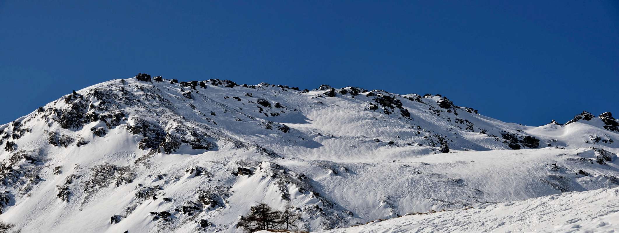
From the "Testa" (= Head) of the Rutor or Tete du Ruitor (3.486m) it goes down toward South a rocky buttress that, after having formed the Hill of the Morion (3.385m), it lowers in a series of rocky quotas (3.214m, 3.112m, 3.006m) such to form the South Ridge of this important mountain, sets among the Valley of La Thuile to West and that of Valgrisenche in East. This buttress is dividing of two small walloons of this last valley and with the same orientation of which above:
1) - the "Vallone" of Saint Grat (what it begins from the little Villages of Fernet (1.726m), Usellières and Surier/Truche (1.785m) immediately sets to South of the Artificial Dike or Lake of Beauregard) that salt with direction Northwest toward the Chapel of Saint Grat near the homonym Lake (2.462m) and it is extinguished with the two following homonyms Glaciers Dessous and Dessus (=Below and Superior);
2) - the Valley of the Arp Vieille, more breadth and circumscribed among this buttress and a secondary crest directed to East that, departing from the Pass of Morion, finishes above Valgrisenche and on which the Shelter of the Angels is set (2.940m; ex Shelter goes Clea Scavarda her to fire) dividing with the "Vallone" of Morion more to North; and it is long the Valley of the Arp that the slope happens to the homonym mountain. In fact the buttress, after the real South Crest of the Rutor or Ruitor, forms a said Pass Forclaz du Bré (2.829m; Refuge Captain Florio) for then to rise again himself through a brief and small Crest North-northwest to the Mont Arp Vieille (2.963m); over it continues toward Southeast toward a little saddle (2.688m; three minuscule military refuges devoted to the Captain Ricci) and, after two a little important quotas (2.720 and 2.673m) it finishes with the Mont Pelà (2.524m), really above the Southern bank of the dam. You treats therefore of a mountain "military" and also on the Peak an entrenchment exists in stone; in the centuries passed as in the last World war it served to garrison the famous, underlying and near one With the du Mont (2.639m) hands of entry from France to the Valley of Aosta. Alpinely speaking, it deals with a beautiful excursion with good glimpses on the underlying Lac de Saint Grat and on the crest of frontier that from the Head of the Rutor it is addressed toward the dorsal Becca du Lac, With the de the Sachère, Gran Becca du Mont, Mont de the Ane-Col de Reculaz and Col du Mont; more in there the sight it pushes him on the pursuance of the same crest spacing progressively around three Ormelunes, on Becca of Suessa and on the Great Sassière (3.751m; the tallest peak of the chain of the "Valgrisa" and above the Val of Isère). Trip also very frequented (especially in the intermediary lines of the approach) with the snow rackets and, of year in year, more and more classical for the ski-mountaineering.
1) - il Vallone di San Grato (che s'inizia dai piccoli Villaggi di Fernet (1.726 m), Usellières e Surier/Truche (1.785 m) posti subito a Meridione della Diga Artificiale o Lago di Beauregard) risalente con direzione Nordovest verso la Cappella di Saint Grat presso l'omonimo Lago (2.462 m) ed estinguentesi con i due successivi omonimi Ghiacciai Dessous e Dessous (di Sotto e di Sopra);
2) - il Vallone dell'Arp Vieille, più largo e circoscritto tra questo contrafforte ed una cresta secondaria orientata ad Est che, partendo dal Col du Morion, va a terminar sopra Valgrisenche e sulla quale è posito il Rifugio degli Angeli (2.940 m; ex Rifugio Clea Scavarda andato a fuoco) divisorio con il Vallone di Morion più a Settentrione; ed è lungo il Vallone dell'Arp che avviene la salita all'omonimo monte. Infatti il contrafforte, dopo la vera e propria Cresta Sud del Rutor o Ruitor, forma un colle detto Forclaz du Bré (2.829 m; Ricovero Capitano Florio) per poi rialzarsi tramite una breve Crestina Nord-nordovest al Mont Arp Vieille (2.963 m); oltre prosegue verso Sudest verso una selletta (2.688 m; tre minuscoli ricoveri militari dedicati al Capitano Ricci) e, dopo due quote poco importanti (2.720 e 2.673 m) termina con il Mont Pelà (2.524 m), proprio sopra la sponda Meridionale della diga. Si tratta quindi di una montagna "militare" ed anche sulla Vetta esiste un trinceramento in pietra; nei secoli passati come nell'ultima Guerra Mondiale serviva a presidiare il famoso, sottostante e vicino Col du Mont (2.639 m) porta d'ingresso dalla Francia alla Valle d'Aosta.Alpinisticamente parlando, si tratta di una bella escursione con ottimi colpi d'occhio sul sottostante Lac de Saint Grat e sulla cresta di frontiera che dalla Testa del Rutor s'indirizza verso la dorsale Becca du Lac, Col de la Sachère, Gran Becca du Mont, Mont de l'Ane-Col de Reculaz e Col du Mont; più in là la vista si spinge sul proseguimento della cresta medesima spaziando progressivamente sui tre Ormelune, sulla Becca di Suessa e sulla Grande Sassière (3.751 m; la vetta più alta della catena della Valgrisa e sopra la Val d'Isère). Gita anche molto frequentata (soprattutto nei tratti intermedi dell'Avvicinamento) con le racchette da neve e, di anno in anno, sempre più classica per lo sci-alpinismo.
 |
 |
First Ascents
- First on the summit: Unknown.
- In winter: Unknown.
Getting There
BY CAR:- From Torino, Milano, etc: Motorway A5. Exit at Aosta Ovest. Drive on SS.26 toward Mont Blanc as far as Leverogne (780m).
- From Switzerland: through the Grand Saint Bernard Tunnel or the namesake Pass. Drive to Aosta, then follow the direction for Courmayeur on SS.26 as previously, reaching Leverogne.
- From France: through Mont Blanc Tunnel or Petit Saint Bernard Pass. It is not necessary to take Motorway A5: you can drive on SS.26, in the direction of Aosta as far as Leverogne. Once close to the Village of Leverogne (780m), turn left if you come from Aosta or turn right coming from Mont Blanc, following along the Regional Route for Valgrisenche. Pass many small Villages, including Rochefort, La Ravoire, Chamencon, La Bethaz, and Valgrisenche (1.664m), the main center of the namesake valley. Turn right for the Village of Bonne (1.810m) located near the western summit edge of the huge dam that forms the Beauregard Reservoir, practically empty for technical reasons.Past the small Village of Menthieu (1.842m), continue for approximately 5 km along the paved road, which follows parallel to the western shore of the lake, running high above it, and then descend leading to the old Pasture of Surier (1.758m), near the Village of Usellières (1.758m) at the southern end of the lake basin. Before the village there is a ample parking space where you can leave the car.
- Aeroporto "Corrado Gex" Saint Christophe (Aosta).
Approach
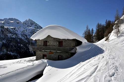
From Valgrisenche (1.664m) he continues with reaching Mondanges (1.652m) and, abandoning her two ramifications on the left (South and East), he continues at first toward North up to the alternative 1.661 meters, where the mute road in opposite sense, and with three narrow hairpin bends on winding road reaches the Fraction of Bonne (1.810m), near the great wall of obstruction of the dike; continuing with a long South-southeast diagonal, dominating of a 150 meters the same one, the following little Fraction of Vieux-Menthieu it is reached (1.848m), where the same continuous as in "Getting There." To abandon the principal road instead and to leave the car near a small parking place (prohibition of transit for the cars and indicative poster in wood "Arp Vieille") to take the dirt road in beaten earth "poderale" that conducts to the Pasture of Arp Vieille (2.220m). Through to climb with a dozen of "tornanti" (= hairpin) through the wood (it coincides in some you treat with the paths n° 14° /14B/15/16; brief shortcuts); through old landslides and meadow expanses, after having forded the Torrent of Arp Vieille, to reach the Alp of Meillares (2.161m), where the road, after a narrow "tornante" and a wider to straight angle toward North, reach the Arp Vieille (2.220m; 1h'00/1h'15); or hundred meters before reaching the same torrent and to quota 2.100 meters around to abandon the "poderale" and to continue on the right (Northwest and then West) through the path n° 16 directly climbing to the alpage (to now calculate a quarter of in less).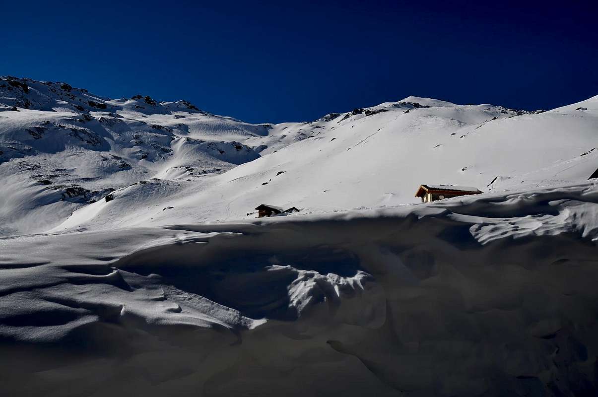
Route A
From the Arp Vieille to continue at first toward Northwest and West-southwest then through the path n° 16, that salt toward the Shelter of the Angels (ex Scavarda to the Rutor) reaching the rests of the Refuge Military Captain Crova, sets in a beautiful open space grassy-detritica (2.405m); from this point to abandon to the right (Northwest) the path for the shelter and, reversing completely the rout with a turn to southeast arc with a small path not numbered, to go himself on the path n° 15 that originates from Meillares (it is possible therefore to directly climb from this place, as in "Approach", discarding the attainment of the Arp Vieille and of the following refuge). From this alternative to quota 2.353 meters to continue toward West up to the following alternative 2.490 meters; here it is possible to climb to the Mont Arp Vieille with two different routes: To) - to Continue on the fund of the vallon with the path n° 15 at it crosses a terrestrial debris with shed blocks, in the middle of thin pastures, passing to East of the quota 2.588 meters and reaching a small source suffered I approach to quota 2.562 meters; here the path transforms him from linear to serpentine hold that, with a two weeks of steep small and narrow hairpin bends and a brief diagonal ending toward Southwest with 270 meters around of gradient, it reaches the Shelter Capitano Florio to the Hill Forclaz du Bré (2.829m; 2h'00 from the Arp Vieille; 3h'00/3h'15 from Bonne), overcoming a slope grassy-debris. From the Forclaz or Pass du Bré, where that Brés it means Breuil or of terminal pasture, to go up again along a trace between broken rocks and deposits and with moderate inclination on the little Crest North-northwest, that easily and shortly it conducts to the Summit, near a small fortification in stone (E; F; 0h'30; in total from Bonne 3h'30/4h'00).Dall'Arp Vieille continuare verso Nordovest dapprima ed Ovest-sudovest poi tramite il sentiero n° 16, che sale verso il Rifugio degli Angeli (ex Scavarda al Rutor) raggiungendo i resti del Ricovero Militare Capitano Crova, posto in una bella spianata erboso-detritica (2.405 m); da questo punto abbandonare a destra (Nordovest) il sentiero per il rifugio ed, invertendo completamente la rotta con un giro ad arco a Sudest con un piccolo sentiero non numerato, portarsi sul sentiero n° 15 che proviene da Meillares (è possibile quindi salire direttamente da questa località, come in "Approach", scartando il raggiungimento dell'Arp Vieille e del successivo ricovero). Da questo bivio a quota 2.353 metri proseguire verso Occidente fino al successivo bivio 2.490 metri; qui è possibile salire al Mont Arp Vieille con due differenti vie: A)- Continuare sul fondo del vallone con il sentiero n° 15, che attraversa un terreno detritico con blocchi sparsi, in mezzo a magri pascoli, passando ad Est della quota 2.588 metri e raggiungendo una piccola sorgente subito appresso a quota 2.562 metri; qui il sentiero si tramuta da lineare a stretta serpentina che, con una quindicina di ripidi tornantini ed un breve diagonale finale verso Sudovest con 270 metri circa di dislivello, raggiunge il Ricovero Capitano Florio al Colle Forclaz du Bré (2.829 m; 2h'00 dall'Arp Vieille; 3h'00/3h'15 da Bonne), superando un versante erboso-detritico. Dalla Forclaz o Passo du Bré, dove quel Bré significa Breuil o pascolo terminale, risalire lungo una traccia tra rocce rotte e detriti e con moderata pendenza sulla piccola Cresta Nord-nordovest, che facilmente e brevemente conduce alla sommità, presso una piccola fortificazione in pietra (E; F; 0h'30; in totale da Bonne 3h'30/4h'00).
MAPS:
 |
 |
 |
 |
 |
Route B
From the alternative 2.490 meters to abandon the path n° 15 on the floor valley and to go up again toward Southwest with the path 14B, that it crosses the morainic Northern Slope of the little Saddle 2.688 meters, between the Mont Arp Vieille and the Crest West-northwest of the Mont Pelà (2.524m) to East, reaching it near two small barracks in downfall calls Shelter Captain Ricci; from these following the Crest Southeast to reach a bystander to quota 2.751 meters and with the same one that becomes rockier, but also always easy, to reach the Peak (same time of the precedent itinerary combining to which a pleasant crossing can be effected it).Dal bivio 2.490 metri abbandonare il sentiero n° 15 sul fondovalle e risalire verso Sudovest con il sentiero 14B, che percorre il versante Settentrionale morenico della piccola Sella 2.688 metri, tra il Mont Arp Vieille e la Cresta Ovest-nordovest del Mont Pelà (2.524 m) ad Oriente, raggiungendola presso due piccole caserme in rovina chiamate Ricovero Capitano Ricci; da queste seguendo la Cresta Sudest raggiungere una terza a quota 2.751 metri e con la medesima che diviene più rocciosa, ma pur sempre facile, raggiungere la Vetta (più o meno stesso tempo del precedente itinerario abbinandolo al quale si può effettuare una piacevole traversata).
E/F per l'Escursionismo; MS o per Sciatori di Medio Livello per lo Sci-Alpinismo.
Equipment
Standard for Excursions or with snowshoes also by ski-mountaineering.Standard da Escursionismo oppure con racchette da neve o da sci-alpinismo.
 |
 |
 |
 |
 |
Campings
Remember that free camping is forbidden (except for emergency reasons, over 2.500m, from darkness until dawn).Mountain Conditions
- You can get meteo information at the official site of the Regione Valle d'Aosta:
- Valle d'Aosta Meteo
Webcam
- WEBCAM on Aosta Valley:
- Webcam
Books and Maps
BOOKS:- "Il Parco Nazionale del Gran Paradiso (Valli Soana-Orco-Rhêmes-Valgrisenche)" di Giulio Berutto, I.G.C. Torino 1979.
- "Guida dei Monti d'Italia – Alpi Graie Centrali" di Alessandro Giorgetta - Club Alpino Italiano/Touring Club Italiano, 1985 (in Italian).
- "Diari Alpinistici" di Osvaldo Cardellina e Indice Generale accompagnato da Schedario Relazioni Ascensioni 1964-2019 (inediti).
 |
 |
 |
- Kompass "Gran Paradiso Valle d'Aosta Sentieri e Rifugi" Carta turistica 1:50.000.
- L'Escursionista "Valgrisenche Val di Rhêmes" Carta dei sentieri (n° 3) 1:25.000.
- Enrico Editore Ivrea-Aosta "Gruppo del Gran Paradiso" 1:50.000.
- I.G.C. Istituto Geografico Centrale "Valsavarenche-Valle di Rhêmes-Valgrisenche" Carta dei sentieri e dei rifugi (carta n° 102) 1:25.000.
Important Information
- REGIONE AUTONOMA VALLE D'AOSTA the official site.
- FONDAZIONE MONTAGNA SICURA Villa Cameron, località Villard de la Palud n° 1 Courmayeur (AO) Tel: 39 0165 897602 - Fax: 39 0165 897647.
- SOCIETA' DELLE GUIDE DI VALGRISENCHE
- A.I.NE.VA. (Associazione Interregionale Neve e Valanghe).
Useful Numbers
- Protezione Civile Valdostana località Aeroporto n° 7/A Saint Christophe (Ao) Tel. 0165-238222.
- Bollettino Meteo (weather info) Tel. 0165-44113.
- Unità Operativa di Soccorso Sanitario Tel. 118.