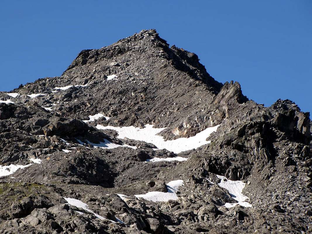
This mountain, though well visible from the well known lakes of Belle Combe, is rarely climbed. It rises between the Lex Blanche (2.670m; NW) and Tachuy (2.673m; ENE) passes and some confuse it with the, slightly higher, Dent Rouges W summits. Near the summit one can easy find 2° world war surplus. Fine view on the below lakes of Bella Comba, Tachuy and on the Vanoise National park.
Montagna non molto frequentata, anche se ben in vista dai molto conosciuti Laghi di Bella Comba. A cavallo dei Colli della Lex Blanche (2.670 m; a NW) e Tachuy (2.673 m; a E-NE). E' confusa a volte con le elevazioni più a W delle Dents Rouges, di poco più alte. Nei pressi della cima è facile riscontrare residui bellici del secondo conflitto mondiale. Ottima la vista sui sottostanti Laghi di Bella Comba, del Tachuy e sul Parco Nazionale della Vanoise.
First Ascents
First ascent on the summit: Unknown.
First ascent in winter: Unknown.
N-NE Eperon: Osvaldo Cardellina, Marco Cossard and Giuseppe Lamazzi, (Oct 02th, 1983).
Getting There
BY CAR:
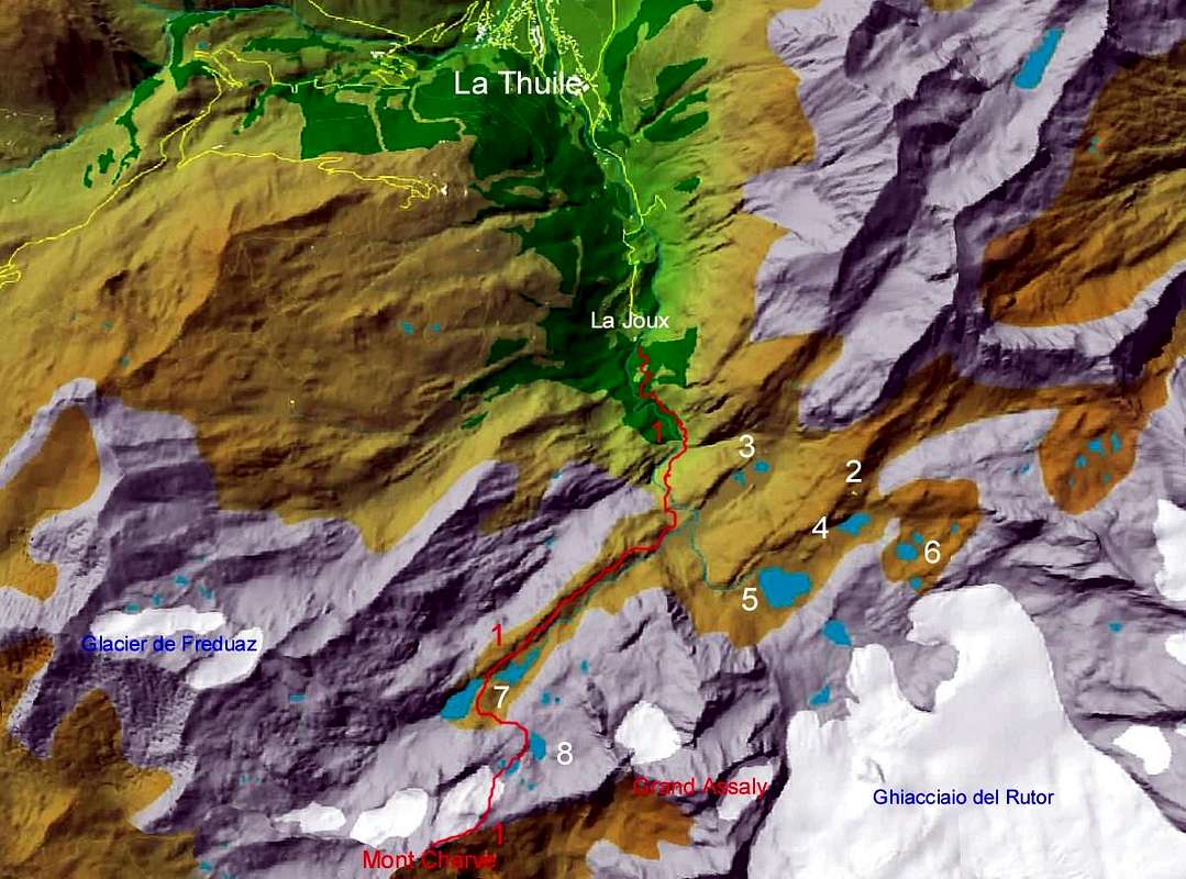
From the Morgex exit of Motorway A5 (921m), continue for about 3 km on SS.26 towards Pré Saint Didier (1.017m). SS.26 becomes the main street of the small city and then continues toward Colle del Piccolo San Bernardo (2.188m). After several hairpins, and past the Villages of Elevaz (1.302m) and La Balme (1.309m) reach the famous ski resort of La Thuile (1.441m). Turn left on the bridge that crosses Dora di La Thuile in the direction of the Village of La Joux. After about 2 km from the bridge, having past a large square, cross another bridge on the Dora to the right. (From this point on, the road, although paved, is quite narrow. Proceed with caution.) After 1 km get to La Joux (1.607m) and park in one of the two parking lots, which are large but sometimes fill up in August. For this reason, access past the second bridge is limited at certain times. Be there before 9 AM to avoid problems, or take the shuttle bus to cover the last stretch.
IN AUTO:
Dall'uscita dell'Autostrada A5 nel Comune di Morgex (921 m) proseguire per circa 3 km lungo la SS.26 verso il Paese di Pré Saint Didier (1.017 m); addentrarsi nella via centrale del paese e proseguire sempre lungo la SS.26 che porta al Colle del Piccolo San Bernardo (2.188 m). Dopo numerosi tornanti e, superate le Frazioni di Elevaz (1.302 m) e La Balme (1.309 m), si giunge alla famosa località sciistica di La Thuile (1.441 m); svoltare a destra sul ponte che attraversa la Dora di La Thuile e dirigersi verso la Frazione di La Joux (1.607 m). Dopo circa 2 km e, superato un ampio piazzale, riattraversare sempre sulla destra un altro ponte sulla Dora (attenzione da questo punto la strada, seppur asfaltata, è molto stretta, procedere con cautela) e dopo circa 1 km. si giunge a La Joux (1.607 m); qui posteggiare l'auto in uno dei due ampi parcheggi, a volte insufficienti nel mese di agosto. Per questo motivo, relativamente al tratto dopo il secondo ponte, c'è una limitazione oraria all'accesso dei mezzi privati, che comunque non tocca chi arriva prima delle 9. In alternativa esiste comunque una navetta bus.
BY PLANE:
Aeroporto "Corrado Gex" Saint Christophe (Aosta).
Route
From La Joux (1.607m) up along the path bordering to the E the Rutor Stream and its 3 fine waterfalls. At the fork 2.100m turn to the right along the path (8) leading to Bella Comba Valley, cross (bridge) the stream coming down from the Lake of Seracs, arriving into a valley with smooth slabs; a step leads to a plain with the remains of a barrack. Follow the path up to a first lake then to a second one near the effluent (2.379m) and follow the S bank. To SE then to SW follow along the path leading, after passing the five lakes, up to the Tachuy Pass (2.673m). Along the easy ENE ridge, on easy stones, to the summit (4h'30/5h'00).
Descent: Coming back is along the same route.
Dalla Frazione di La Joux (1.607 m) risalire il sentiero, che a E fiancheggia il Torrente du Rutor e le sue tre belle cascate. Raggiunto il bivio a quota 2.100 metri svoltare verso destra sul sentiero che conduce al Vallone di Bella Comba (sentiero n°8); attraversare su comodo ponte il torrente proveniente dal Lac des Seracs, arrivando in una valletta tra antiche banconate levigate dal ghiacciaio. Superato un gradone, si raggiunge un successivo pianoro con i resti di una casermetta. Il sentiero, sempre a N del Torrent de la Belle Combe, raggiunge il primo omonimo lago sovrastandolo e raggiunge il secondo presso il suo emissario (2.379 m); seguire per breve la sponda S. Con direzione SE prima e SW dopo, superare su in piccolo sentiero, i magnifici cinque Laghi del Tachuy (2.550 m e 2.569 m i più grandi). Per pietraie e nevai raggiungere il Colle del Tachuy (2.673 m). Percorrere la facile cresta E-NE di frontiera e per blocchi alla vetta (4h'30/5h'00).
Discesa: Lungo la stessa via di salita.
Difficulty
The route is rated E/F.
L'itinerario è classificato E/F.
Gear
Hiking gear.
Da escursionismo.
Campings
Remember that free camping is forbidden (except for emergency reasons, over 2.500m, from darkness until dawn).
Mountain Condition
You can get meteo information at the official site of the Regione Valle d'Aosta:
Parents refers to a larger category under which an object falls. For example, theAconcagua mountain page has the 'Aconcagua Group' and the 'Seven Summits' asparents and is a parent itself to many routes, photos, and Trip Reports.

 5564 Hits
 88.19% Score
 26 Votes