Despite its height, Mont Chetif is a summit that you cannot miss, due to its position exactly in front of Mont Blanc. It is situated NW of Courmayeur: from here it is the big round head that you see at your left, looking at the Mont Blanc summit. There are different ways to arrive at the top: the most interesting one is partially equipped with chains. You cannot call it exactly a "ferrata", as the length of the part equipped is about 100 meters, while the total difference in height is 1.151m, but in any case you must take care. Originally it was an ancient path used by the shepherds to reach the high pastures of the area. In a sunny and clear day, it seems you can touch with your fingers the Mont Blanc top, just in front of you.
Getting There
Mont Blanc from the summit of Mont Chetif
Courmayeur can be reached from Geneva via Chamonix and the MB tunnel, or from Milan or Turin via the A5 toll highway - By car: through the Val Veny mountain road until the car park at La Visaille/Plan Lognan or (500m below) at Plan Veny (near the picnic area). Private access to this road is regulated from 1 to 20 August . - By the bus service: one trip each 40 minutes. In Courmayeur the bus can be taken from the Bus Station (near the tunnel highway entrance). (from Signorelli's Pointe Lechaud page with his agreement)
Ferrata
Dent du Geant and Grandes Jorasses from one of the panoramic viewpoints
Before Courmayeur, turn on your left and follow the sign Val Veny; after a while, you will cross the Dora river; park at your right after the bridge: there is a lane on your left, going to the climbing clinic (palestra di roccia), follow this lane, that crosses another one, starting from the North Parking of Dolonne. Walk along some pastures, leave them on your left; at your right there are on the rock the routes of the climbing clinic. Left them, and continue till the first yellow indication: number 4. The path becomes steep, and after a while, in front of you, the first exposed slabs, equipped with chains. From now on, the route is a path that sometime stops in front of slabs, or chimneys, or short couloirs, from five to ten meters: to pass them you can help yourselves by the chains, some metallic steps, some metallic bolts locked in the stone; in some slabs, at the beginning, the shepherds created some steps in the rock, to make easier the progression. Pass a small wooden bridge, go up in a larches bush, that makes soft the lane in autumn, and stop at the various panoramic points. You can admire the valley, on the bottom, and the sector of Mont Blanc Group including Grandes Jorasses, above Val Ferret. The view is magnificent; the path is sometimes steep. When you see the summit of Mont Chetif, with the big statue of the Virgin, the tecnical difficulties are ended; afterwards, on a big tree there are a lot of small plaques with the names of the most important routes of the Monte Bianco, and the year of their first climb. Your path meets the one that arrives at your right from Pre' de Pascal; continuing at your left, another slab with chains, the last one, will help you to come down of a few meters on the narrow and exposed lane that crosses the east steep slopes of Mont Chetif; the path becomes quite steep, and between rododendron trees and scree slopes suddenly appears the imposing Mont Blanc summit. At your left, a lane to the farms of the area; at your right, a steep path between the rocks arrives at the top. The view towards Mont Blanc Group leaves you without words.... Coming down for a few meters, you will reach the big Virgin Statue. To come back, follow the same lane till a junction: at your left, a lane brings you to Pra Neiron, in the basin of Plan Checrouit, from here you can come back to Dolonne and to the car. A very interesting possibility is to turn right; take care, this lane is not always sufficiently signed,it is steep, rocky and quite difficult. Avoid it in the case of fog, there is a part with some rocks to climb down: they are easy, but take care. Come down straight to the Zerotta chairlift; a comfortable traverse brings you to Pre' de Pascal, where there is the arrival of a winter cable car, a restaurant and a bar. This is the last balcoon on the Brenva; from here follow the road and some trails in the fields to reach the main road of Val Veny; right side, in a few kilometers till the car.
Important: no water from the starting point to Pre' de Pascal....!!!!
This trail was equipped in the year 1986, the 200th anniversary of the first ascent to Monte Bianco, and the Pope John Paul II celebrated the "Angelus" on the top of Mont Chetif.
When To Climb
Autumn trees of Courmayeur down in the valley
From June to October, according to the season conditions.
Camping
Free camping in the Aosta Valley region is not allowed below 2.500m However, it's tolerated if you don't create hassles or particular troubles. This includes, of course, making fires in the woods! Here's a list of camping in Val Veny, all accessible by car or by bus from Courmayeur. In strict alphabetical order:
Camping Aiguille Noire - in Val Veny, at Zerotta, near the lower station of the chair lift. (tel. +39 0165 869041 Fax +39 0165 843097). A good place for families and big groups. Used to be also the cheapest, but price right now are almost the same everywhere.
Camping Cuignon - in Val Veny between Zerotta and the military barracks (tel +39 0165 869073 Fax +39 0165 842861). This one is a bit of a question mark for me, because I don't know anyone who's been there. From outside it looks quite neat and smaller than:
Aiguille Noire Camping La Sorgente - in Val Veny, in a clearing of the forest called Peuterey, exactly under the Mont Noir south face (tel. +39 0165 848209 or, in summer +39 0165 869089). The location of this one is gorgeous (the ancient forest nearby is said to have been a Celtic worship centre). They're really climber-friendly, and the camping itself is well organised.
On the Val Ferret:
Camping Grandes Jorasses in Val Ferret between Planpincieux and the golf course. (tel +39 0165 869708). Being near Planpincieux, it's a lively and well placed on a partially wooden area.
Camping Tronchey - in Val Ferret just in front of the entrance of the golf club, right under the monstrous Tronchey Wall of the Grandes Jorasses. (tel. +39 0165 869707). Nearby there's Bar Tronchey (or "Chez Giulietta"), where at noon you can eat an incredible rabbit with polenta.
If you're willing to spend a little more, a nice alternative to camping can be the Chalet Val Ferret. It's a seven rooms little hotel + restaurant at Arnouva, where the Val Ferret road ends - just in front of the opening of the Triolet basin. The place is beyond gorgeous, and you're in a good position both for climbing and hiking. A guide who's a friend of mine used it for his climbing stage for kids and was really enthusiastic. Also, you can ask the manager for any kind of indications on the nearest sport and trad climbs of the trendy Triolet area. On the other hand, if you don't like camping and you're tight with money, you can consider sleeping in one of the low altitudes "refuges". There are the Elisabetta hut, at the head of Val Veny near the Col de La Seigne, the Elena hut and the UGET Monte Bianco hut. In all these places accommodation varies - the Elisabetta hut is quite spartan, the Elena hut almost a luxurious, the Monte Bianco hut somewhere halfway. If you want to consider staying there for several days, you've to book well in advance (In August and July these places become packed with hikers doing the Tour De Mont Blanc.) (from Signorelli Pointe Lechaud page with his agreement - I asked him to use the same description for the common part, to help the foreigners that intend to come to the area, and that can be confused finding different indications for the same things......)
Mountain Conditions
You can get meteo information at the official site of the Regione Valle d'Aosta:
Parents refers to a larger category under which an object falls. For example, theAconcagua mountain page has the 'Aconcagua Group' and the 'Seven Summits' asparents and is a parent itself to many routes, photos, and Trip Reports.

 16951 Hits
 93.58% Score
 43 Votes


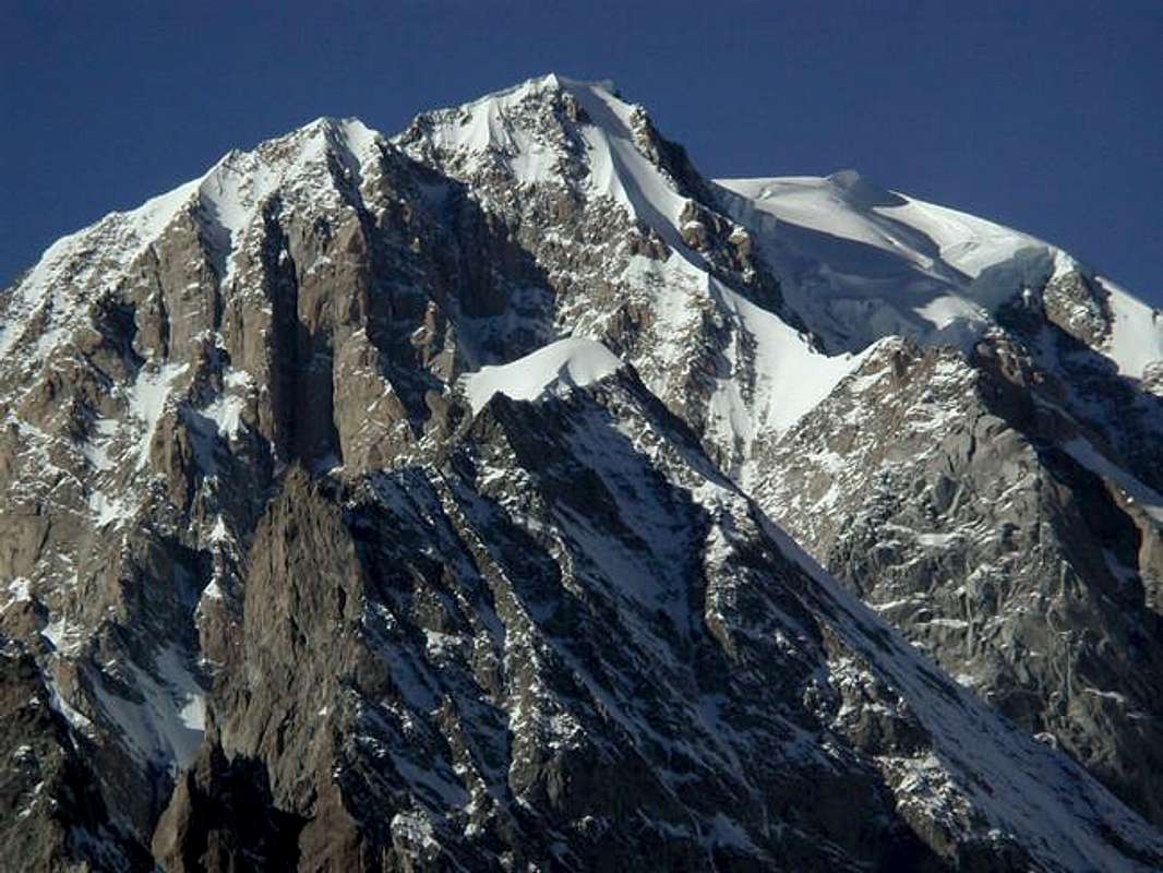 Mont Blanc from the summit of Mont Chetif

 Dent du Geant and Grandes Jorasses from one of the panoramic viewpoints
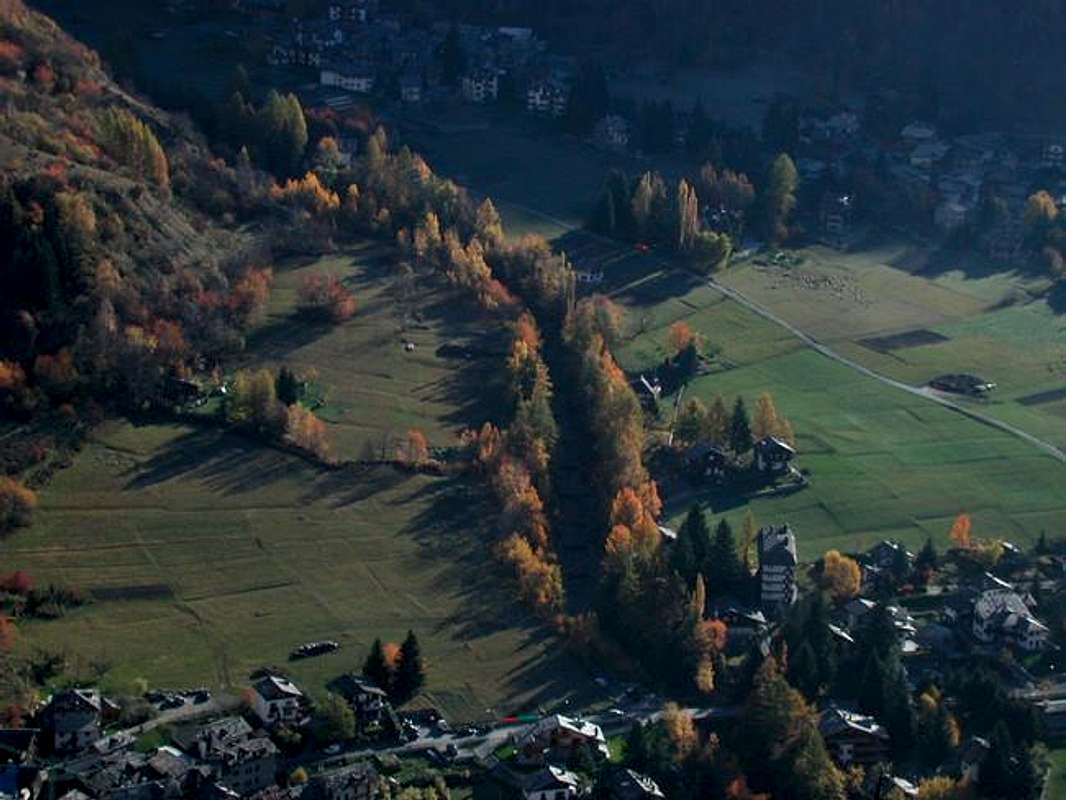 Autumn trees of Courmayeur down in the valley


