
-
 6649 Hits
-
 84.82% Score
-
 19 Votes
|
|
Mountain/Rock |
|---|---|
|
|
45.68650°N / 7.01202°E |
|
|
Mountaineering |
|
|
10023 ft / 3055 m |
|
|
Overview
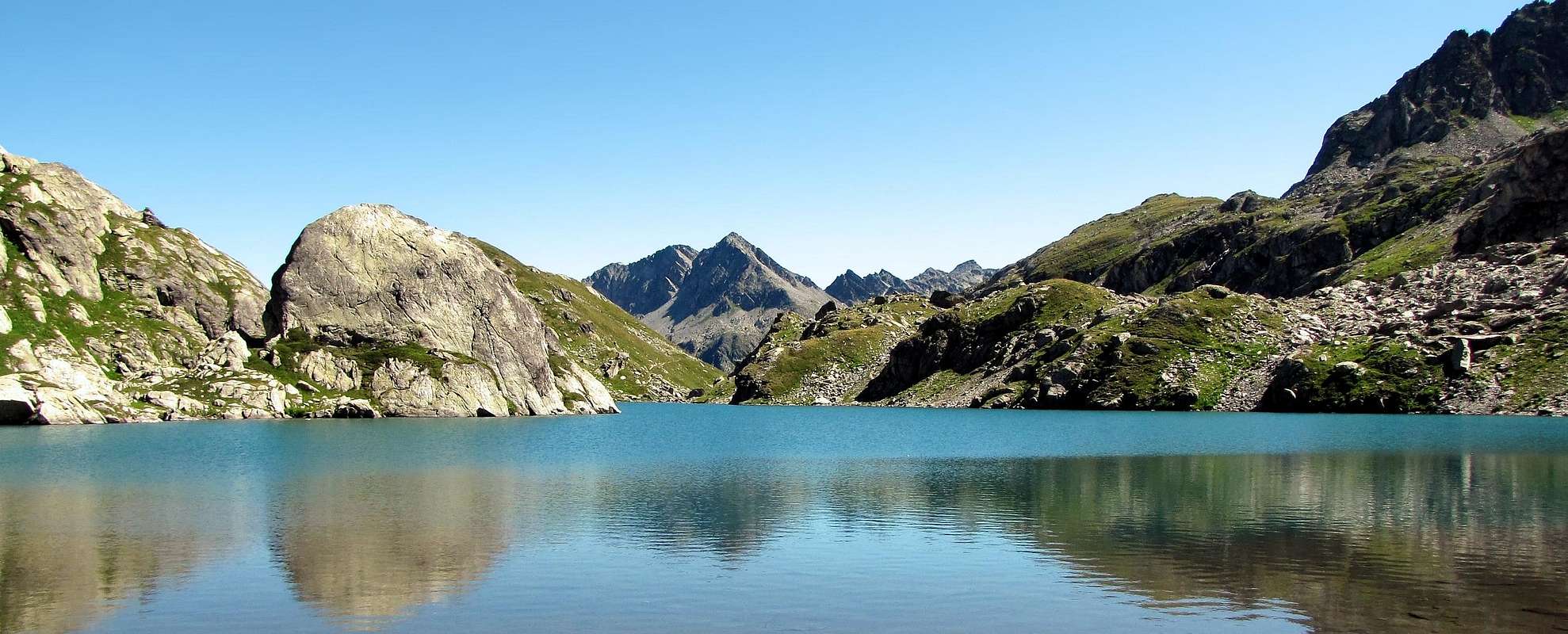
Small triangular pyramid between the Valley of "Leseney" (North), "Comba Sorda" (West) and of the "Comba des Usellettes" (Southeast) between "La Thuile, Arpy and Chabodey-Derby". From its peak a magnificent panorama on the: "Gruppo del Rutor, Grande Assaly, Mont Colmet, Mont Monchette, Testa del Paramont, Monte Paramont and Torre del Tighet".
Piccola piramide triangolare a cavallo dei Valloni di Leseney (Nord), della Comba Sorda (Ovest) e della Comba des Usellettes (Sud-est) tra La Thuile, Arpy e Chabodey-Derby. Vetta poco frequentata ma con colpi d'occhio eccezionali su: Gruppo del Rutor, Grande Assaly, Mont Colmet, Mont Monchette, Testa del Paramont, Monte Paramont e Torre del Tighet.
First Ascents
- First on the summit: Unknown.
- In winter: Unknown.
- NW Arête: A. Adami, L. Savoye and C. Paradisi, (Jul 17th, 1938).
- N-NE Arête (from Lacs de Goillat-E Slope of "Colletto" 2713m Quote 2.806-2.975m): Osvaldo Cardellina, Christian Cardellina, Giuseppe Lamazzi and Marco Cossard, (Jul 03th, 1983).
- E-SE Arête (from Leseney Pass): Osvaldo Cardellina, Christian Cardellina, Giuseppe Lamazzi and Marco Cossard, (Jul 03th, 1983) in descent.
Getting There
BY CAR:- From the Morgex exit of Motorway A5 (921m), continue for about 3 km on SS.26 Towards Pré Saint Didier (1.017m). SS.26 becomes the main street of the small city and then continues toward Colle del Piccolo San Bernardo (2.188m). After several hairpins, and past the Villages of Elevaz (1.302m) and la Balme (1.309m) reach the famous ski resort of La Thuile (1.441m). Turn left on the bridge that crosses Dora di La Thuile in the direction of the Village of La Joux. After about 2 km from the bridge, having past a large square, cross another bridge on the Dora to the right. (From this point on, the road, although paved, is quite narrow. Proceed with caution.) After 1 km get to La Joux (1.607m) and park in one of the two parking lots, which are large but sometimes fill up in August. For this reason, access past the second bridge is limited at certain times. Be there before 9 AM to avoid problems, or take the shuttle bus to cover the last stretch.
- Dall'uscita dell'Autostrada A5 nel Comune di Morgex (921 m) proseguire per circa 3 km lungo la SS.26 verso il Paese di Pré Saint Didier (1.017 m), addentrarsi nella via centrale del paese e proseguire sempre lungo la Strada Statale n°26 che porta al Colle del Piccolo San Bernardo (2.188 m). Dopo numerosi tornanti e, superate le Frazioni di Elevaz (1.302 m) e la Balme (1.309 m), si giunge alla famosa località sciistica di La Thuile (1.441 m); svoltare a destra sul ponte che attraversa la Dora di La Thuile e dirigersi verso la Frazione di La Joux (1.607 m). Dopo circa 2 km e, superato un ampio piazzale, riattraversare sempre sulla destra un altro ponte sulla Dora (attenzione da questo punto la strada, seppur asfaltata, è molto stretta, procedere con cautela) e dopo circa 1 km. si giunge a La Joux (1.607 m). Qui posteggiare l'auto in uno dei due ampi parcheggi a volte insufficienti nel mese di agosto. Per questo motivo, relativamente al tratto dopo il secondo ponte, c'è una limitazione oraria all'accesso dei mezzi privati, che comunque non tocca chi arriva prima delle 9. In alternativa esiste comunque una navetta bus.
- Aeroporto "Corrado Gex" Saint Christophe (Aosta).
Route
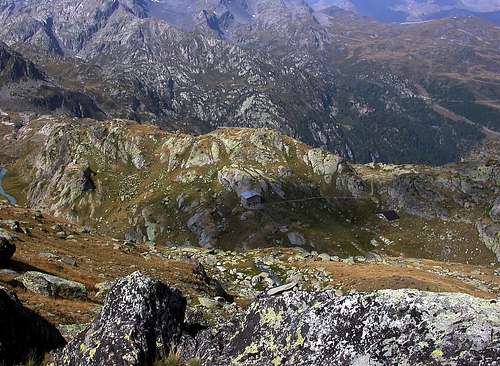
The ascent for Rifugio Albert Deffeyes starts in front of "Bar Delle Cascate" on trail n° 3. Pass a wooden bridge on the left and after about 15 minutes you'll come to the first of the three spectacular Rutor Falls. Continue along the trail and leave Alpeggio di Parchet (1.772m) to your right. The trail continues up large steps and in a bit less than one hour passes by the second waterfall, which is not visible from the trail, but is marked by a sign. After another 15 minutes you'll reach the sign for the the third waterfall. Continue on the steep trail for another 20 minutes to a fork. Take the well-marked left branch that leads to the hut. (The right branch, numbered 8, leads to the beautiful Lakes of Bella Comba.) Climb to the small Col (2.130m) and then descend bending slightly to the right until Lago Glacier (2.143m). Cross the small wooden bridge over the lake outlet and, leaving Alpeggio Glacier to your right, climb steeply along wide hairpins to the plateau where Rifugio Albert Deffeyes is located at (2.494m). To leave (Southeast) the path that leads to the Refuge and in direction (Northeast) to reach the Usellettes Valley. To go back on tracks in direction (Northeast) and for debris ascend to the Leseney Pass (2.823m), to continue long the short crest (E-Southeast) and with enough route easy (I°-II°-II°+, in integral) to reach the peak (3h'30/4h'00 from La Joux).Descent: from the same route.
Iniziare la salita verso il Rifugio Albert Deffeyes sul sentiero davanti al "Bar delle Cascate" contrassegnato con il n° 3, dopo aver oltrepassato un ponte in legno sulla sinistra e dopo circa 15' si incontra la prima del tre spettacolari Cascate del Rutor; proseguire lungo il sentiero e oltrepassare (sulla destra) l'Alpeggio di Parchet posto sulla destra (1.772 m). Continuare sempre lungo il sentiero che ora si inerpica a gradoni e dopo circa 55' si oltrepassa la seconda cascata (segnalata da un cartello e non visibile dal sentiero principale). Dopo circa altri 15' si incontra il cartello della terza cascata. Continuare sul ripido sentiero per altri 20'. Qui il sentiero si divide: prendere quello sulla sinistra ben segnalato che conduce al rifugio (quello di destra recante il n° 8 porta ai magnifici Laghi di Bella Comba). Risalire sino al Colletto (2.130 m) per poi iniziare la salita verso il Rifugio Albert Deffeyes. Scendere leggermente sulla destra e proseguire fino al Lac Glacier (2.143 m.); oltrepassare il ponticello in legno che sovrasta l'emissario del lago e, lasciando sulla destra l'omonimo alpeggio, riprendere a salire decisamente lungo ampi tornanti fino a raggiungere l'altipiano, dove è sito il Rifugio Albert Deffeyes (2.494 m). Lasciare a (Sud-Est) il sentiero che conduce al rifugio e in direzione (Nord-Est) raggiungere il Vallone di Usellettes. Risalire su tracce in direzione (Nord-Est) e per detriti salire al Passo di Leseney (2.823 m), continuare lungo la breve cresta (E-Sud-Est) e con percorso abbastanza facile (I°-II°-II°+, in integrale) raggiungere la vetta (3h'30/4h'00 da La Joux).
Discesa: per la stessa via di salita.
 |
 |
 |
 |
 |
Difficulty
Easy anf for Experienced Hikers EE/F+.
L'itinerario è da considerarsi EE/F+.
Equipment
Standard mountaineering equipment.
Da alto escursionismo.
Huts
 |
Campings
Remember that free camping is forbidden (except for emergency reasons, over 2.500m, from darkness until dawn).
Mountain Condition
- You can get meteo information at the official site of the Regione Valle d'Aosta:
- Valle d'Aosta Meteo
- Meteo: You can find more weather information on the website 3B Meteo:
- La Thuile
Webcam
- WEBCAM on Aosta Valley:
- Webcam
Books and Maps
BOOKS:
- "Guida delle Alpi Occidentali", di Giovanni Bobba e Luigi Vaccarone C.A.I. Sezione di Torino Volume II (parte II), 25 Maggio 1896.
- "Monte Bianco Valdigne" di Alessio e Giuseppe Nebbia, Ed. Musumeci, (1989).
- "La Thuile e dintorni" di Giuseppe Alliod, Ed. G. Alliod (1994).
- "Rifugi e bivacchi in Valle d'Aosta", di Cosimo Zappelli aggiornata da Pietro Giglio, Musumeci Editore.
- "I Rifugi della Valle d'Aosta" di Stefano Ardito, Ed. Guide iter, Febbraio 2003.
- "Guida dei Monti d'Italia–Alpi Graie Centrali" di Alessandro Giorgetta - Club Alpino Italiano/Touring Club Italiano, 1985 (in Italian).
- "Valdigne gli itinerari escursionistici", di Alessandro Giorgetta, Ed. Zanichelli, Giugno 1981.
- "La Thuile" di Giuseppe Alliod, Ed. Musumeci (1989).
- "Diari Alpinistici" di Osvaldo Cardellina e Indice Generale accompagnato da Schedario Relazioni Ascensioni 1964-2019 (inediti).
 |
 |
 |
 |
 |
MAPS:
- Kompass "Gran Paradiso Valle d'Aosta Sentieri e Rifugi", Carta turistica 1:50.000.
- L'Escursionista "La Thuile-Piccolo San Bernardo", (carta n° 2) 1:25.000.
- A.I.A.T. La Thuile, "La Thuile Pianta dei Sentieri", 2004 (Plastico).
- Carta Comunità Montana "Valdigne e Mont Blanc Les Sentiers", 2001 1:50.000.
- I.G.C. Istituto Geografico Centrale "Il Parco Nazionale del Gran Paradiso", 1:50.000.
- I.G.C. Istituto Geografico Centrale Torino "Monte Bianco-Courmayeur-Chamonix M.B.-La Thuile", (carta n° 107), 1:25.000.
- Studio F.M.B."Monte Bianco-Mont Blanc", Bologna 1988 1:50.000.
Important Information
- REGIONE AUTONOMA VALLE D'AOSTA the official site.
- FONDAZIONE MONTAGNA SICURA Villa Cameron, località Villard de la Palud n° 1 Courmayeur (AO) Tel: 39 0165 897602 - Fax: 39 0165 897647.
- SOCIETA' DELLE GUIDE DI VALGRISENCHE.
- COMPAGNIE DES GUIDES RUTOR Fraz. Entrèves tel/fax 0039.0165.885574 e-mail Guidealpine@lathuile.it
- A.I.NE.VA. (Associazione Interregionale Neve e Valanghe).
Useful numbers
- Protezione Civile Valdostana località Aeroporto n° 7/A Saint Christophe (Ao) Tel. 0165-238222.
- Bollettino Meteo (weather info) Tel. 0165-44113.
- Unità Operativa di Soccorso Sanitario Tel. 118.