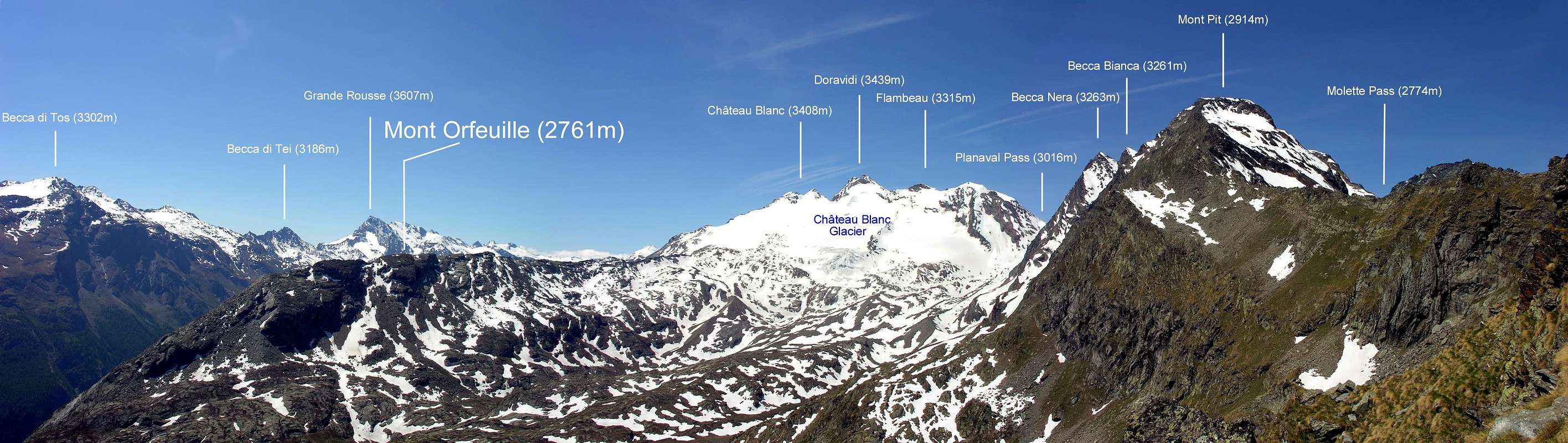
Along rocky ridge from the southern sector of the Château Blanc glacier extends to the "Torre Tonda" north of the small and charming village of Planaval (Arvier). Excellent landscape point in a mountain hight environment.
Lungo crestone roccioso che dal settore meridionale del ghiacciaio dello Château Blanc si estende verso la Torre Tonda a nord della piccola e ridente frazione di Planaval (Arvier). Eccellente punto panoramico in un ambiente di alta montagna.
First Ascents
First on the summit: Unknown.
In winter: Unknown.
Getting There
BY CAR:
From Torino, Milano, etc: Motorway A5. Exit at Aosta Ovest.
From Switzerland: through the Grand Saint Bernard Tunnel or the namesake Pass.
From France: through the Mont Blanc Tunnel or Petit Saint Bernard Pass: It is not necessary to take Motorway A5: you can drive on SS.26, in the direction of Leverogne.
BY PLANE:
Aeroporto "Corrado Gex" Saint Christophe (Aosta).
Itinerary
From the City of Aosta (583m) follow the SS.26 in the direction of Mont Blanc. Near the Village of Leverogne (780m) turn left on the Regional Road for Valgrisenche. Go past the Villages of Rochefort, La Ravoire, and Chamencon; then turn right for the Village of Planaval (1.557m), about 10 km from Leverogne. You can park here and continue on foot along the paved road in the direction of the Village of La Clusaz (1.631m): once out of the village, turn left after two switchbacks. But, if you are lucky, you can also park your car just in front of the start of the trail, that is clearly visible and well-marked.
Dalla città di Aosta (583 m) si percorre la SS.26 per il Monte Bianco e giunti nei pressi dell'abitato di Leverogne (780 m) si imbocca sulla sinistra strada regionale per la Valgrisenche, dopo aver superato le frazioni di: Rochefort, La Ravoire e Chamencon girare sulla destra per la frazione di Planaval (1.557 m) situata a circa 10 km. da Leverogne. Qui lasciare l'auto e proseguire a piedi lungo la strada asfaltata verso il villaggio di La Clusaz (1.631 m) dopo aver superato i due tornanti dopo l'abitato svoltare sulla sinistra (sentiero evidente e ben segnalato da cartelli).
Route Description
Gain the initial, steep 500m of elevation (path 21-21A - Alta Via2) and go past a water outlet at (2.060m) to reach the first plateau. Continue along the bank of the stream that flows from the Château Blanc Glacier. Past a small wooden bridge, the trail climbs steeply for another 100 meters before reaching the second plateau, where another small bridge is located. Cross the bridge and aim straight for the Baracche (Huts) of Fond (2.342m), 2h'00. From the pasture, (path 21 - variant Alta Via 2) continue along the valley until you reach an area debris on the left (NE) of the summit. From this point turn to the right up to a plan with a few small ponds to the right of the ridge and to the moraine of the glacier Château Blanc. With still an uphill and keeping slightly to the left to the summit by due attention to the rubble and debris. From La Clusaz 3h'15/3h'45. From La Clusaz 3h'15/3h'45.
Superati i primi ripidi 500 metri di dislivello (sentiero 21-21A - Alta Via2) e dopo aver superato una presa d'acqua (2.060 m) si raggiunge il primo pianoro, continuare sul lato del torrente che scende dal ghiacciaio dello Château Blanc, dopo aver oltrepassato un piccolo ponticello in legno il sentiero risale ripido per un altro centinaio di metri dopodiché si raggiunge un secondo pianoro dove anche qui è posto un piccolo ponte, attraversalo e dirigersi verso le baracche di Fond (2.342 m)2h'00. Dall'Alpeggio (sentiero 21 - variante Alta Via 2) continuare lungo il vallone fino a raggiungere una zona detritica sulla sinistra (NE) della vetta. Da questo punto volgere sulla destra fino a un piano con alcuni piccoli laghetti a destra della cresta e verso la morena del ghiacciaio di Château Blanc. Con ancora un tratto in salita e tenendosi leggermente sulla sinistra si raggiunge la vetta facendo debita attenzione agli sfasciumi ed ai detriti. Da la Clusaz 3h'15/3h'45.
Difficulty
The route is rated EE (expert hikers).
L'itinerario è classificato EE (escursionisti esperti).
Equipment
Standard hiking equipment.
Standard da escursionismo.
Campings
Remember that free camping is forbidden (except for emergency reasons, over 2.500m, from darkness until dawn).
Mountain Condition
Meteo: you can find all the needed informations at the official site of the Valle d'Aosta Region:
Parents refers to a larger category under which an object falls. For example, theAconcagua mountain page has the 'Aconcagua Group' and the 'Seven Summits' asparents and is a parent itself to many routes, photos, and Trip Reports.

 7086 Hits
 85.87% Score
 21 Votes