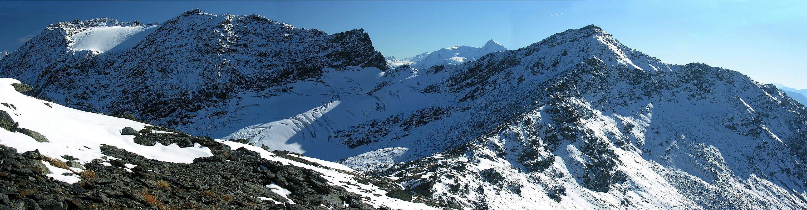
Not much slender pyramid, placed south of the Piccolo San Bernardo pass, in the high Valley of the Little Saint Bernard (2.202m) among the tall Valley of La Thuile in Italy and the Vanoise, with his Park, in France; composed by three crests (N-NE toward the Top of the Bella Valletta, E-SE to Col du Glacier and the following Summit of the Louie Blanche and the Monts Fréduaz and West toward the Tete de the Ane and the Traversette Pass in French territory, possesses an only and homonym glacier abandoned on his oriental side and to originate from the same, after a succession of three splendid small lakes abandoned to his borders, the Torrent des Maisonnettes along the Vallon de Ponteilles. * The etymology of the toponym is referable, more than to a reference to unlikely inhabitants coming from the Vallese Swiss the simple definition of "Mountain of the Inhabitant f the valley" it also exists in the GROUP of the Emilius Mountain a Plan du Valé and the same peak Mont du Valé was denominated anciently. In the same chain we find a Pas du Valaisan and the adjacent Mont du Valaisan between the Western Top of the Red Point of the Emilius and the Point Garin, (verifiable placename already in the Guide of the Western Alps 1896, by Giovanni Bobba and Luigi Vaccarone, to the pages 33 and 215, where in this last the three existing itineraries are listed to the epoch: "to) For the face north - west", where as slope must be intended Northwest of the Saddle 2.743m and "almost always along the line of border", or the Crest NE or by Normal Route, "b) For the south crest - east" and finally "c) For the south crest - west", or from the Pass of the Traversette). Very frequented by the transalpine slope through the crest above quoted (path-muletrack with departure from the Ancient Hospice of Petit Saint Bernard near the Museum and more aloft, wanting, Telesiège Chardonnet) and also enough in the skiing district of La Suche/La Suche de Cantamont, immediately to South of the Tourist and Skiing center of La Thuile; the numerous chair lifts and existing ski lifts facilitate not also the approach of it during the bad season but the winter slope or in beginning in spring always introduces him so banal for the big frames exposed on the Slopes Oriental and Northern. However a splendid trip of ski mountaineering remains even if, for the conformity of its territory exposed to snowlides at least in the approaches actually to the attainment of the three existing crests, it asks for prudence, experience and as such it is suitable for BSA (good skiers mountain climber; to see the 2 photos of Gabriele). On his crest of border with France they still exist in clean evidence you hospitalize and shelters, military entrenchments and rests of protections with grid to warning of sad memory of the ranks of strengths during the Second World Conflict. Beautiful sights to East-southeast on the GROUP of the Rutor with his glaciers and lakes, as well as on the neighbor Grand Assaly (3.172m) and more to East-Northeast on the Mont Paramont (3.301m).
Piramide non molto slanciata e posizionata a meridione del Colle del Piccolo San Bernardo (2.202 m) tra l'alta Valle di La Thuile in Italia e la Vanoise, con il suo Parco, in Francia; composta da tre creste (N-NE verso la Cima della Bella Valletta, E-SE verso il Col du Glacier e la successiva Cima della Louie Blanche ed i Mont Fréduaz ed O verso la Tete de l'Ane ed il Col de la Traversette in territorio francese, possiede un unico ed omonimo ghiacciaio adagiato sul suo fianco orientale ed originante dal medesimo, dopo una successione di tre splendidi laghetti adagiati ai suoi bordi, il Torrent des Maisonnettes lungo il Vallon de Ponteilles. * L'etimologia del toponimo è riconducibile, più che ad un riferimento ad improbabili abitanti provenienti dal Vallese Svizzero, alla semplice definizione di "Monte del Valligiano", ovvero della valle; esiste altresì nel Gruppo del Monte Emilius un Plan du Valé e la medesima vetta era anticamente denominata Mont du Valé. Nella stessa catena troviamo un Pas du Valaisan e l'adiacente Mont du Valaisan tra la Cima Occidentale della Punta Rossa dell'Emilius e la Punta Garin, (toponimo già riscontrabile nella Guida delle Alpi Occidentali 1896, di Giovanni Bobba e Luigi Vaccarone, alle pagine 33 e 215, dove in quest'ultima vengono elencati i tre itinerari esistenti all'epoca: "a) Per la faccia nord - ovest", dove va inteso come versante NO della Sella 2.743 m e "quasi sempre lungo la linea di confine", ovvero la Cresta NE o Via Normale, "b) Per la cresta sud - est" ed infine "c) Per la cresta sud - ovest", ovvero dal Col de Traversette). Molto frequentato dal versante transalpino tramite la cresta sopra citata (sentiero-mulattiera con partenza dall'Ancien Hospice du Petit Saint Bernard presso il Museum e più in alto, volendo, Telesiège Chardonnet) ed abbastanza percorso anche dal comprensorio sciistico di La Suche/La Suche de Cantamont, subito a S del centro Turistico e Sciistico di La Thuile; le numerose seggiovie e sciovie esistenti ne facilitano anche l'avvicinamento durante la cattiva stagione, ma la salita invernale oppure in inizio di primavera non sempre si presenta così semplice o banale per le grosse cornici esposte sui Versanti Orientale e Settentrionale. Comunque rimane una splendida gita di sci alpinismo anche se, per la conformità del suo territorio esposto a slavine per lo meno negli avvicinamenti sino al raggiungimento delle tre creste esistenti, richiede prudenza, esperienza e come tale è indicata per BSA (buoni sciatori alpinisti; vedere le 2 fotografie di Gabriele). Sulla sua cresta di confine con la Francia esistono ancora in netta evidenza ricoveri, trinceramenti militari e resti di protezioni con reticolato a mò di triste ricordo del dispiegamento di forze durante il Secondo Conflitto Mondiale. Belle viste verso E-SE sul Gruppo del Rutor con i suoi ghiacciai e laghi, nonché sulla vicina Grand Assaly (3.172 m) e più a E-NE sul Mont Paramont (3.301 m).
First Ascents
First on the summit: Unknown.
In winter: Unknown.
Mount Valaisan (?) and traverse through W-NW Edge/Ridge to Antesummit W-NW and Western Fréduaz: G. Bignami lone? or with Company?, in the Eighties?, in ascent from? and to? ***(see Series of Italian Mounts C.A.I./T.C.I. "Alpi Graie Centrali" 1985, pages 268/9, by Alessandro Giorgetta with private informations G. Bignami).
Under NE Crest and W Slope in final part (Italian Normal Route): Unknown.
Mount Valaisan by Integral NE Crest: Emilio Bertona and Osvaldo Cardellina (Jul 20th, 2005) and double traverse (in ascent and in descent) through W-NW Edge/Ridge to Antesummit W-NW and to Roux Pass and to Western Mount Fréduaz: Osvaldo Cardellina, lone and in free climbing; Jul. 20th, 2005, in ascent and in descent and crossing (with Emilio) through Mount Valaisan-Bella Valletta-Quotas 2.767m, 2.710m, 2.731m, 2.720m around, 2.704m toward Mount Belvedere Pass, always Jul. 20th, 2005.
E Slope (completely and directly from the Glacier of Mount Valaisan): Osvaldo Cardellina and Emilio Bertona, (Oct 09th, 2005), in ascent.
SE Crest (from of Great Glacier Pass): Unknown.
W-SW Ridge (from Traversette Pass, or French Standard Route): Unknown.
N Slope (almost entirely and traverse to Saddle 2.743m): Osvaldo Cardellina and Emilio Bertona, (Oct 09th, 2005), in descent.
Getting There
BY CAR:
From Italy: with the Morgex exit of Motorway A5 (921m), continue for about 3 km on SS.26 towards Pré Saint Didier (1.017m). SS.26 becomes the main street of the small city and then continues toward Colle del Piccolo San Bernardo (2.188m). After several hairpins, and past the Villages of Elevaz (1.302m) and la Balme (1.309m) reach the famous ski resort of La Thuile (1.441m). Turn left on the bridge that crosses "Dora di La Thuile", a go on along the same road continue to rise along the SS.26, which leads to the Piccolo San Bernardo Pass.
From France: through the RN.°90 that from Bourg Saint Maurice (813m), almost to entrance of the Isère Valley, Séez Commune (894m; 28 Kms from the Hill of the Piccolo Saint Bernard) and from this toward Villard Dessous, Dessus and Noyeray Villages and to the small tourist and skiing place of the Rosière (1.808m; to 8 Kms~ from the pass).
IN AUTO:
Dall'Italia:con uscita dell'Autostrada A5 nel comune di Morgex (921 m) proseguire per circa 3 km lungo la SS.26 verso il Paese di Pré Saint Didier (1.017 m), addentrarsi nella via centrale del paese e proseguire sempre lungo la SS.26 che porta al Colle del Piccolo San Bernardo (2.188 m). Dopo numerosi tornanti e superate le Frazioni di Elevaz (1.302 m) e la Balme (1.309 m) si giunge alla famosa località sciistica di La Thuile (1.441 m). Svoltare a destra sul ponte che attraversa la "Dora di La Thuile", continuare a salire lungo la SS.26 che conduce al Colle de Piccolo San Bernardo.
Dalla Francia:tramite la SN.90 che da Boug Saint Maurice (813 m), quasi all'ingresso della Val d'Isère, porta al Comune di Séez (894 m; 28 Km dal Passo del Piccolo San Bernardo), Villaggi di Villard Dessous, Dessus e Noyeray e alla piccola località turistica e sciistica di la Rosière (1.808 m; ad 8 Km~ dal valico).
BY PLANE:
Aeroporto "Corrado Gex" Saint Christophe (Aosta).
ITALIAN APPROACHES (from La Thuile Ski Touristic Center/Pont Serrand Village to Ski Station La Suche de Cantamont)
A) - (Through the SS.26 and the carriage way): from the various parking lot of La Thuile to cross the SS.26 of the Little St. Bernard that, climbing toward west, it reaches the inhabited area of Great Golette (1.484m) and, after three angle acute hairpin bends, passes for Saint Bernard of Aoste (+; 1.602m; alternative for the Valleys des Orgères and des Chavannes; fountain) reaching the small village of Pont Serrand. From this point the carriage road, through other five "tornanti" (= hairpin bends) toward South and a more rectilinear line to West, it crosses the Seivaz Tableland leaving to the right immediately (North) the homonym pasture to reach the place Servaz (1.830m; different alps and Restaurant Magnard with mini lake). The same medium others two narrow harpin bends he brings under the Tete de Tsargian (2.078m) near the alternative 1.972 meters; from this, abandoned the SS. n°26 for the "Piccolo" one, he continues along a secondary and parallel road thin to a following alternative; left to West a ramification in earth ("poderale" road) addressed toward the Plan Abondance, direction changes at first decidedly him toward Northeast and then East reaching a triple crossroads near the place of Condemar (1.990m). To still continue toward East and, discarded to the right a further similar ramification to the preceding ones, with others four small "tornanti" (hairpin bends) to pass under the Chair lift Chalet Express, immediately after a last alternative to quota 2.188m that, undoubling in turn himself, it alleges to the low part of the Village of La Suche de Cantamont (2.145m), or to the underlying one La Suche (2.084m); with a last and brief line to reach the parking lot of The Suche of Cantamont (splendid fountain in stone).
A) - (Per mezzo della SS.26 e tramite la strada carrozzabile asfaltata): dai vari parcheggi di La Thuile percorrere la SS.26 del Piccolo San Bernardo che, salendo verso occidente, raggiunge l'abitato di Grande Golette (1.484 m) e, dopo tre tornanti ad angolo acuto, passa per Saint Bernard d'Aoste (+; 1.602 m; bivio per i Valloni des Orgères e des Chavannes; fontanile) raggiungendo il piccolo villaggio di Pont Serrand. Da questo punto la strada carrozzabile, per mezzo di altri cinque tornanti verso S ed un tratto più rettilineo ad O, attraversa il Plan Seivaz lasciando subito a destra (N) l'omonimo alpeggio per raggiungere la località Servaz (1.830 m; diversi alpeggi e Ristorante Magnard con mini laghetto). La stessa tramite altri due stretti tornanti si porta sotto la Tete de Tsargian (2.078 m) nei pressi del bivio 1.972 m; da questo, abbandonata la SS.26 per il Piccolo, si prosegue lungo una strada secondaria e parallela fino ad un bivio successivo; lasciata ad O una diramazione in terra indirizzata verso il Plan Abondance, si cambia decisamente direzione dapprima verso NE e poi E raggiungendo un trivio presso la località di Condemar (1.990 m). Continuare ancora verso E e, scartato a destra un ulteriore diramazione similare alle precedenti, con altri quattro piccoli tornanti passare sotto la Seggiovia Chalet Express, subito dopo un ultimo bivio a quota 2188 m che, sdoppiandosi a sua volta, adduce alla parte bassa del Villaggio di La Suche de Cantamont (2.145 m), oppure alla sottostante La Suche (2.084 m); con un ultimo e breve tratto raggiungere il parcheggio di Le Suche de Cantamont (splendida fontana in pietra).
B) - (Through the path n° 9 and the carriage secondary): from the parking lot 1.447 meters near the place Saint Nicolas, to the entry of La Thuile, to continue for brief line along the SS.26 up to the bridge on the Dora of The Thuile Stream; immediately later to leave on the right (North) the path n° 13, underlying the Gym of Rock in the place Faubourg, taking instead, with Southwest direction, the path n° 9 that, passing for Sainte Barbe (+), it reaches the inhabited area of Great Golette. Always through the same direction, "cutting" three times the SS. to reach the Village of Pont Serrand and, along a secondary stream, to again cross the same one as soon as before the curve in direction of the Alp Serva (1.800m~); the small stream is forded and again, after having transited near the Pasture 1920meters, with a brief diagonal ending it is inserted us on the carriage road of the preceding itinerary near a small log cabin and with this it is reached The Suche of Cantamont (E; 2h'00/2h'30).
B) - (Tramite il sentiero n° 9 e la carrozzabile secondaria): dal parcheggio 1.447 metri presso la località Saint Nicolas, all'ingresso di La Thuile, proseguire per breve tratto lungo la SS.26 fino al ponte sulla Dora di La Thuile; subito dopo lasciare sulla destra (N) il sentiero n° 13, sottostante la Palestra di Roccia in località Faubourg, prendendo invece, con direzione SO, il sentiero n° 9 che, passando per Sainte Barbe (+), raggiunge l'abitato di Grande Golette. Sempre tramite la stessa direzione, "tagliando" tre volte la SS. raggiungere il Villaggio di Pont Serrand e, lungo un torrente secondario, attraversare nuovamente la stessa, appena prima della curva in direzione dell'Alpe Serva (1.800 m~); si guada nuovamente il piccolo torrente e, dopo essere transitati presso l'Alpeggio 1.920 m, con un breve diagonale finale ci si inserisce sulla strada carrozzabile dell'itinerario precedente presso una piccola baita e con questo si raggiunge Le Suche de Cantamont (E; 2h'00/2h'30).
C) - (Through her from the of Speedway that Parking Rutor): from the center than from the La Thuile (1.447m), Parking of Entreves, to go up again they govern the carriage one a Sainte Barbe and, governments direction South, toward the complex of the from where of Planibel, slightly folding up an Southeast, the term of the same one is reached near which Camping Rutor positioned on the western bank of the Torrent du Rutor; from the signal of prohibition of transit for vehicles and also bicycles, parking lot of the of near (1.475m~), it begins the slope along the Speedway, numbered also come to path n°9 and history to climb up to the Fourclaz Pass (2.486m). Through two long hairpin bends to actually climb to the Alp of Essuez; with a following and a long rectilinear line, passing below the Chair lift Wood Express and of the Funivia La Suche, to reach a first alternative. To leave the secondary pursuance addressed Garin to the Alp to South (1.780m) and to continue instead to Northwest reaching a second alternative to quota 1.800 m; to abandon here also the secondary branch of the road of connection with the SS. n°26 and, through other seven hairpin bends, to arrive at the end of the Ski lift of the Pylons, to quota 1.900m~. With a series of others four briefer to reach the place of La Suche (2.084m; stings of arrival of the Chair lift Wood Express and point of departure of that of Chalet Express); shortly through the carriage road to reach the place of La Suche de Cantamont (2.145/2.170m~; E; 2h'00/2h'30).
C) - (Per mezzo della Superstrada dal Parking Rutor): dal centro di La Thuile (1.447 m), Parking Entreves, risalire con la carrozzabile a Sainte Barbe e, con direzione S, verso il complesso del Planibel donde, piegando leggermente a SE, si raggiunge il termine della medesima presso il Camping Rutor, posizionato sulla sponda occidentale del Torrent du Rutor; dal segnale di divieto di transito per veicoli ed anche biciclette, presso il parcheggio (1.475 m~), inizia la salita lungo la Superstrada, numerata anche come sentiero n°9 e tale da salire fino al Colle della Fourclaz (2.486 m). Con due lunghi tornanti salire sino all'Alpe di Essuez; con un successivo ed un lungo tratto rettilineo, passando al di sotto della Seggiovia Bosco Express e della Funivia La Suche, raggiungere un primo bivio. Lasciare a S il proseguimento secondario indirizzato all'Alpe Garin (1.780 m) e continuare invece verso NO raggiungendo un secondo bivio a quota 1.800 m; abbandonare anche qui il ramo secondario della strada di collegamento con la SS. n°26 e, per mezzo di altri sette tornanti, arrivare al termine della Sciovia dei Piloni, a quota 1.900 metri circa. Con una serie di altri quattro più brevi raggiungere la località di La Suche (2.084 m; punto di arrivo della Seggiovia Bosco Express e punto di partenza di quella di Chalet Express); in breve per mezzo della strada carrozzabile raggiungere la località di La Suche de Cantamont (2.145/2.170 m~; E; 2h'00/2h'30).
ITALIAN and FRENCH APPROACHES (from La Thuile Ski Turistic Center/Pont Serrand or from Bourg Saint Maurice/Séez/la Rosière to Little Saint Bernard Pass)
D) - From the Hill of the Little Saint Bernard attainable 1) - from Italy through the SS.26 that from the Center Turistic and Skiing of La Thuile (1.447m) near the Hotel Dora, Villages of Little and Great Goletta (1.484m), small Village of Pont Serrand (1.611m), Alp Servaz (1.830m), winding road 1.861m near the Cretaz Pasture (1.886m), Restaurant Magnard (1.885m around), Wine Cellars of Eaux Rousses (2.000m~), Plan of the Abundance (2200m~) it reaches it placing side by side the Ancient Roman Road with its Mansio, as soon as under the pass (2.185m). * * Slightly more in low to Northeast of the footstep it is situated the beautiful Inferior Lake of Verney (2.088m; dirt parking), to the feet of the Mount Belvedere to Southeast and Lancebranlette Mountain toward West and the entry of the "Vallone" of the Tormotta/Breuil, surely deserving of a standstill and relative visit directly through a brief deviation from the SS.26 or afoot through a small descent from the hill, with two separate and not numbered paths, that reach the northern or southern banks of it (Touristic; 0h'15).
2) - Or from France through the Route Nationale n°90 that from Bourg Saint Maurice (the Roman ancient Bergintrum; 813m) hands to Séez Commune (894m; to 28 Kms from the pass of the Little Saint Bernard); from this village, the carriage one, left on the right the NR.202 toward the Val of Isère, salt to the Villages of Villard Dessous and Dessus and Noyeray and, neglected to deviation on the right toward Montvalézan, it goes up again with to lot of windings road and always mostly narrow to the Mount Head and, moving dark even itself toward right, it arrives to the small tourist and skiing place of the Rosière (1.808m; hotels, restaurants and chair lifts) to 8 Kms around from the pass. Going up again toward North the same double a groin that goes down from the neighbor Pass of the Embrasures (2.303m) and from the the Roc Noir (2.252m; various Téléski and Télésiège coming from the Rosière Village), almost to the fear of it of the long Buttress West-southwest coming from the Mount Valaisan, to enter so in the Valley of Reclus; it entirely crosses it, at first to half coast and then on the valley floor. Left on the left a deviation on dirt road "poderale" for the Pontets (2.044m; = the small Bridge above the Torrent of Reclus) and for the Chapelle (= Chapel +; 1.982m) and for the Alps of the Commune (1.983m), the same one reaches the Baraque des Douaniers (= the Customs Officers' House; 2.113m), it still abandons to the left a road "poderale" addressed to the "Vallon" of Teppié, with homonym stream, and to the upper Lac sans Fond (= Loch without Fund; 2.467m) and in succession it reaches, after a double windings road to 180°, the Ancien Hospice of Petit Saint Bernard (2.189m; ruins to quota 2.158m) with his Museum, the Chapel Chanoux, the Jardins Botanique Chanousia (= botanical Garden devoted Pierre Chanoux to the Abbé), the Columns of Joux (= Columna Jovis) and the Celtic Cromlech (2.189m), near the hill.
The VERNEY LAKE (2.088m) and an other tiny loch, near the SS.26 of the LITTLE SAINT BERNARD PASS (2.189m) between Itlaly and French.
D) - Dal Colle del Piccolo San Bernardo raggiungibile 1) - dall'Italia tramite la SS.26 che dal Centro Turistico e Sciistico di La Thuile (1.447 m) Hotel Dora, Villaggi di Petite e Grande Golette (1.484 m), piccolo Villaggio di Pont Serrand (1.611 m), Alpe Servaz (1.830 m), tornante stradale (1.861 m~) vicino l'Alpe Cretaz (1.886 m), Ristorante Magnard (1.885 metri circa); parcheggio in terra), Cantine des Eaux Rousses (2.000 m~), Piano dell'Abbondanza (2.200 m~) lo raggiunge affiancando l'Antica Strada Romana con la sua Mansio, appena sotto il colle (2.185 m).* * Leggermente più in basso a NE del passo è collocato il bel Lago Inferiore di Verney (2.088 m; parcheggio in terra), ai piedi del Monte Belvedere verso SE e del Monte Lancebranlette verso O ed all'ingresso del Vallone della Tormotta/Breuil, sicuramente meritevole di una sosta e relativa visita direttamente per mezzo di una breve deviazione dalla SS.26 o a piedi tramite una piccola discesa dal colle, con due distinti e non numerati sentieri, che ne raggiungono le sponde settentrionali o meridionali (Turistico; 0h'15).
2) - Oppure dalla Francia per mezzo della RN.90 che da Bourg Saint Maurice (l'antica Bergintrum dei Romani; 813 m) porta a Séez (894 m; a 28 Km dal valico del Petit Saint Bernard); da questo villaggio, la carrozzabile, lasciata sulla destra la Route Nationale n°202 verso la Val d'Isère, sale ai Villaggi di Villard Dessous e Dessus e Noyeray e, trascurata una deviazione sulla destra verso Montvalézan, risale con tornanti molto e sempre maggiormente stretti alla Tete du Mont e, spostandosi ancora di più verso destra, arriva alla piccola località turistica e sciistica di la Rosière (1.808 m; alberghi) ad 8 Km circa dal valico. Risalendo verso N la stessa doppia un costolone che scende dal vicino Col des Embrasures (2.303 m) e dal le Roc Noir (2.252 m; vari Téléski e Télésiège provenienti da la Rosière), quasi al temine del lungo Contrafforte O-SO proveniente dal Mont Valaisan, per entrare così nel Vallon du Reclus; lo percorre interamente, dapprima a mezza costa e poi sul fondovalle. Lasciata sulla sinistra una deviazione su strada poderale per le Pontet (2.044 m; = il piccolo Ponte sopra il Torrent du Reclus) e per la Chapelle (+; 1.982 m) e per gli Alpeggi di la Commune (1.983 m), la stessa raggiunge la Baraque des Douaniers (= Casa dei Doganieri; 2.113 m), abbandona a sinistra ancora una strada poderale indirizzata al Vallon de Teppié con omonimo torrente ed al soprastante Lac sans Fond (= Lago senza Fondo; 2.467 m) ed in successione raggiunge, dopo un doppio tornante a 180°, l'Ancien Hospice du Petit Saint Bernard (2.189 m; ruderi a quota 2.158 m) con il suo Museum, la Chapelle Chanoux, le Jardin Botanique Chanousia (= Giardino botanico dedicato all'Abbé Pierre Chanoux), la Colonne de Joux (= Columna Jovis) ed il Cromlech celtico (2.189 m), presso il colle.
Routes (A, B, C or Italian Routes) and (D or French Street)
The military mule-track to South, toward the snowy Quota 2.767m and the terminal part of the ridge to the Bella Valletta Point.
A) - (from The Suche of Cantamont and Classic Route through Bella Valletta, by the military mule-track, and traverse through NE Ridge and East Slope in final part): to address him verse I always South-southwest through the dirt road "poderale" - path n° 9, parallelly to the Chair lift La Combe, reaching the alternative of the station of arrival of the Chair lift Chaz Duraz, under the small Top of the Earths Noire (2.419m); to continue with the same direction passing under the Chair lift her Combe, the Ski Lift Chaz Duraz Express and reaching the point of arrival of the "Sciovia" La Suche to quota 2.312m. To continue in parallel to the right of the Ski Lift Gran Testa a will reaching his point of arrival, where the Chair lift Argillen Express also comes, to quota 2.402m; to continue along the Plan of the Bedalla reaching the alternative for Pass of the Fourclaz (2.486m), that he leaves to the right (North; descriptive poster in direction of the Little St. Bernard Pass, of the Hill of the Belvedere Mountain and with path n° 9D for the Mont Valaisan). To take this last that, with direction it brings him Southeast from the Bedalla Tableland to the Pian of Suche, going down through the grassland toward the Torrent of the Belvedere Mountain, and to easily ford him; to reach so the alternative with the path not numbered that it climbs from Arnouvaz/Cerellaz, as soon as before meeting the Chair lift of the Belvedere. To pass below of it and to cross a second tiny torrent contemplating 2.704m to the rocky band that constitutes the East Spur of the quota; to go up again with a diagonal, exposed but easy and sure, doubling the rocky promontory and entering the "Vallon" de Ponteilles, really above a series of lower case lakes. Suddenly changing direction in the opposite sense, to continue along the path-mule track underlying the rocky crest for then to gradually go himself more to Southwest in direction of the a flat-bottomed of a small valley on the deep waterfund of which it flows a light trace of water (often snowfields); to pass over and, with a brief but fatiguing climbed on narrow hairpin bends and in downfall, to reach the Quota 2731m on the crest of border Italian/French, meeting numerous entrenchments and wire nettings. To continue as soon as under the same one with the mule track, always n° 9D, that returns to be sure and under good conditions, passing as soon as under in East of the Quotas 2.710m and 2.767m; the same one, with light turn to arc and to the left along the Crest N and with a small barracks in undoing in sight, it reaches the ante summit grassy and then, through a series of easy rocks, the Top of Bella Valletta (2.811m; 1h'15/1h'30). To go down for his Crest S-SW on a slender trace, that edges some rocks, reaching the small and grassy Saddle 2.743m; to continue through NE of the Mont Valaisan Crest, with the path, that, progressively estranging himself from the same one, it becomes from easy to some more binding, cause the overcoming of some great rocks stacked alternate to some brief rocky plate. In the last line the same goes up again the terminal part of the East Slope, enough steep; with some hairpin bends, and progressively passing under to a small military bunker/depot, brings him against a small rocky rib, that he goes up again for brief line. Therefore turning to the right (North), with a diagonal enough steep, it again brings him against the Crest NE, without however to reach it, and immediately going out through a carving to South of the signal (poster) of the Peak (EE; F+; completely to see again in the evaluation of the difficulties in the case of tall snow or verglass with often great sticks of ice on the final rocks; in this case it is worthwhile to finish the ascension along the Northern Slope; 1h'30/2h'00; altogether from 3h'00 to 5h'00 according to the conditions).
A) - (da Le Suche du Cantamont, la mulattiera militare per Bella Valletta e traversata tramite la Cresta NE ed il Versante E nella parte terminale): indirizzarsi verso S-SO sempre tramite la strada "poderale" - sentiero n° 9 parallelamente alla Seggiovia La Combe raggiungendo il bivio della stazione di arrivo della Seggiovia Chaz Duraz, sotto la piccola Cima delle Terre Noire (2.419 m); continuare con la stessa direzione passando sotto la Seggiovia La Combe, la Sciovia Chaz Duraz Express ed arrivando al punto di arrivo della Sciovia La Suche a quota 2.312 m Continuare in parallelo a destra della Sciovia Gran Testa arrivando al suo punto di arrivo, ove giunge anche la Seggiovia Argillen Express, a quota 2.402 m; proseguire lungo il Piano della Bedalla raggiungendo il bivio per il Col de la Fourclaz (2.486 m), che si lascia a destra (N; cartelli segnaletici in direzione del Piccolo San Bernardo, del Colle del Monte Belvedere e con sentiero n° 9D per il Mont Valaisan). Prendere questo ultimo che, con direzione SE, si porta dal Pian della Bedalla al Pian di Suche scendendo attraverso la prateria verso il Torrente del Monte Belvedere e guadarlo agevolmente; raggiungere così il bivio con il sentiero non numerato che sale da Arnouvaz/Cerellaz, appena prima di incontrare la Seggiovia del Belvedere. Passarne al di sotto ed attraversare un secondo minuscolo torrente mirando alla fascia rocciosa che costituisce il Contrafforte E della Quota 2.704 m; risalire con un diagonale esposto, ma facile e sicuro, doppiando il promontorio roccioso ed entrando nel Vallon de Ponteilles proprio sopra una serie di minuscoli laghi. Cambiando repentinamente direzione nel senso opposto, continuare lungo il sentiero-mulattiera, sottostante la cresta rocciosa, per poi dirigersi gradualmente più a SO in direzione del fondo piatto di un piccolo vallone sul fondale del quale scorre una lieve traccia di acqua; passare oltre e, con una breve ma faticosa salita su tornanti stretti ed in rovina, raggiungere la Quota 2.731 m sulla cresta di confine italo/francese incontrando numerosi trinceramenti e reticolati. Continuare appena sotto la medesima con la mulattiera, sempre n° 9D, che ritorna ad essere sicura ed in buone condizioni, passando appena sotto ad oriente delle Quote 2.710 m e 2.767 m; la stessa, con leggero giro ad arco ed a sinistra lungo la Cresta N e con una piccola caserma in disfacimento in vista, raggiunge l'anticima erbosa e poi, per mezzo di rocce facili, la Cima di Bella Valletta (2.811 m; E; 1h'15/1h'30). Scendere per la Cresta S-SW, su una traccia esile che contorna alcuni massi, raggiungendo la piccola ed verbosa Sella 2743 m e continuare per mezzo della Cresta NE del Mont Valaisan. Il sentiero, allontanandosi progressivamente dalla stessa, diventa da facile ad un po' più impegnativo, causa il superamento di alcuni grandi massi accatastati alternati a qualche breve placca rocciosa. Nell'ultimo tratto lo stesso risale la parte terminale del Versante E, abbastanza ripido. Con alcuni tornanti, e passando sotto ad un piccolo bunker/deposito militare, progressivamente ci si porta contro una piccola costola rocciosa, che si risale per breve tratto; quindi volgendo a destra (N), con un diagonale abbastanza ripido, ci si porta nuovamente contro la Cresta NE, senza però raggiungerla ed uscendo per mezzo di un intaglio subito a S del segnale (cartello) della vetta (EE; F+; completamente da rivedere nella valutazione delle difficoltà nel caso di neve alta o verglass con spesso candelotti di ghiaccio sulle rocce finali; in questo caso conviene terminare l'ascensione lungo il Versante N; 1h'30/2h'00; complessivamente da 3h'00 a 5h'00 a seconda delle condizioni).
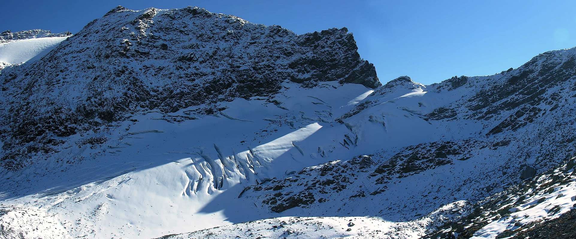
At the beginning of Northeast Ridge and the midst part of East Slope; in foreground the Western Summit of Mounts Fréduaz, also called The Louie Blanche Point, over the Great Glacier Pass, and in bottom the Glacier of Valaisan.
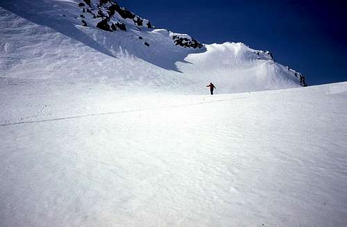
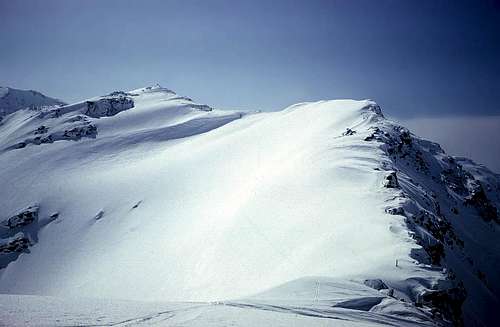
B) - (from The Suche of Cantamont with the precedent itinerary actually to the Saddle 2.743m , brief descent and crossing on the Glacier of Mount Valaisan, gone up again of the same up to the of Great Glacier Pass and Southeast Crest): from the Saddle 2.743m to shortly go down, for scarce about fifty meters, and easily for deposits and "clapeys" (= broken rocks to blocks) verse Southwest; passing as soon as above to the tallest of the small glacial lakes at basic the of the same glacier, to reach it in his northern edge, overcoming at first to rocky band with slope in diagonal from left toward right through to snowy small couloir or of deposits and wrecks, according to the season. Or, without losing rates, continuous to, through light crossing in slope or in plain forgery, with the same characteristics bringing itself against the rocky "banconates" that go down with immersion Southeast from the Oriental Slope of the Mount Valaisan entering the glacier, in this houses, hundred meters above. To manage among the various opened crevasses (you see photo and tape n° 1) bringing itself with slope of modest inclination toward the center of the same; not to underestimate it in case of mantle snowy uniform to the beginning of the season, when the same are covered and disguised. To address him toward a small rocky rib and to go up again it, avoiding to move too much himself toward South against the rout wall rocky de The Louie Blanche or Western Fréduaz, that discharge often and gladly. With a last steep line to go out on the pass; if in this final line a slide was found in "verglass", it is possible to sustain to the right himself (North), going out through a small saddle rounded off on the Southeast Crest to about fifty North meters of the hill. For this, wider in the initial part and more thinned, but also always easy and with broken rocks in the conclusive part (you see photo and tape n° 2), often meeting residual of military wire nettings, in little time the Peak is reached (EE/A; F+; 2h'00/2h'30).
B) - (da Le Suche du Cantamont con il precedente itinerario sino alla Sella 2.743m, breve discesa e traversata sul Glacier du Mont Valaisan, risalita dello stesso fino al Col du Grand Glacier e Cresta SE): dalla Sella 2.743 m scendere brevemente, per una cinquantina scarsa di metri, e facilmente per detriti e "clapeys" (= rocce rotte a blocchi) verso SO; passando appena sopra al più alto dei laghetti glaciali alla base del ghiacciaio medesimo, raggiungerlo nel suo orlo settentrionale, superando dapprima una fascia rocciosa con salita in diagonale da sinistra verso destra tramite un canalino nevoso o di detriti e rottami, a seconda della stagione. Oppure, senza perdere quota, proseguire, per mezzo di leggera traversata in salita od in falso piano, con le stesse caratteristiche portandosi contro le banconate rocciose che scendono con sinclinale SE dal Versante Orientale del Mont Valaisan entrando nel ghiacciaio, in questo caso, un centinaio di metri al di sopra. Destreggiarsi tra i vari crepacci aperti (vedi foto e filmato n° 1) impegnandosi con salita di modesta pendenza verso il centro dello stesso; non sottovalutarlo in caso di manto nevoso uniforme all'inizio della stagione, allorché gli stessi sono coperti e mascherati. Indirizzarsi verso una costoletta rocciosa e risalirla, evitando di spostarsi troppo verso S contro la rotta parete rocciosa de La Louie Blanche o Fréduaz Occidentale, che scarica spesso e volentieri. Con un ultimo tratto più ripido uscire sul colle; qualora in questo tratto finale si trovasse uno sdrucciolo in "verglass", é possibile mantenersi maggiormente a destra (N), uscendo tramite una piccola sella arrotondata sulla Cresta SE ad una cinquantina di metri a Settentrione del colle. Per questa, più larga nella parte iniziale e più assottigliata, ma pur sempre facile e con rocce rotte nella parte conclusiva (vedi foto e filmato n° 2), incontrando sovente residui di reticolati militari, in poco tempo si raggiunge la Vetta (EE/A; F+; 2h'00/2h'30).
To the left (South) the entire Southeast watershed Italy/French Ridge and in bottom the "Vallone" of Ponteilles, over La Joux Village in La Thuile's Valley.
C) - (from La Joux along the Torrent of the Maisonnettes and the "Vallone" of Ponteilles, Lakes of the Glacier Mont Valaisan, glacier and precedent route): from La Joux (1.646m), almost to the southern border of the Valley of La Thuile, not to continue toward this direction reaching a reserved parking lot with adjoining restaurant (1603m); in advance instead, to the poster of prohibition on the dirt road "poderale", to address him verse Southwest in the wood, leaving at first on the right a first isolated pasture and then, on the left, a second (1.682m). Over past a small stream, to leave on the right (North) a more marked path, that conducts to the Alp Arnouvaz Desòt, and to always continue also with the same direction with good path, but not numbered. Old another small secondary torrent, to draw near to the northern bank of the most important Torrent des Maisonnettes, that marks the run toward the little Valley of Ponteilles; approached it and followed it for brief time toward West, he reaches the "Alpeggio" of Maisonnettes (1.894m; 0h'45/1h'00). With light north semicircle, dominating the stream from the tall one and with direction before West and then Southwest, it is reached, to rates 2.000 meters, the dirt road poderale that originates from Arnouvaz Damon (1.975m; * it is possible from Arnouvaz Dèsot along the dirt road "poderale"/path n° 9A to reach Arnouvaz Damon and on "poderale", dark not numbered, to connect him to the Alp Ponteilles) ; he abandons the path that, becoming less marked and going up again among the two branches of the Torrent, it reaches the "Alpeggio" of Ponteilles however (2060m; 1h'00/1h'15; * * from the Maisonnettes Pasture is possible besides, crossed on to small bridge in stone the homonym torrent, to actually go up again along the southern bank of the same one to reach the path n° 9A and, again fording toward North the stream, to reach Ponteilles). You continues instead, same direction, for brief line on the dirt road poderale actually to meet the most important path n° 8, that colleague this last to the Comba (= Basin) Thuilette, to the slopes of the homonym mountain (* * * the same continuous toward the Comba Sozin and relative small lake, for then to continue verse Southeast and, passing above to the Third Fall of the Rutor, to connect himself, as soon as over the Torrent of Rutor, to the High Route n° 2 toward the Shelter Deffeyes with exceptional panoramic run). From Ponteilles to continue in the same direction, always tall above the stream, going up again the homonym "vallone" of it; to quota 2.170 meters, under the back grassy called Ponteilles Point (2.313m), to abandon the path that, turning toward North, it reaches the Chair Lift of the Belvedere, to also abandon the valley that continues toward Bella Valletta and to always continue instead along the Torrent of Maisonnettes, at the base of the Chain of the Fréduaz. To go up again at first this small and narrow "vallone" on scarce traces, pastures, grassy backs and then on moraine, with splendid sights on the three Mounts Fréduaz and their glaciers with suspended seracs, up to reach the base of the glacier near the quota 2.626 meters, next to per second of the four small lakes. From this to go up again shortly time to the first one and ," grafting" itself on the glacier, to connect him to the preceding street (EE/A; F+; 3h'00/3h'30).
Near the Summit the upper part of Ponteilles "Vallone", of Ponteilles Lochs, the beginning of Maisonnettes Torrent and in bottom the rocky/grassy Point of Ponteilles; to the right Fréduaz's lower part of North Face.
C)- (da La Joux lungo il Torrent de Maisonnettes ed il Vallone di Ponteilles, Laghetti del Glacier du Mont Valaisan, ghiacciaio e precedente via): da La Joux (1.646 m), quasi al margine meridionale della Valle di La Thuile, non proseguire verso questa direzione raggiungendo un parcheggio riservato con attiguo ristorante (1.603 m); anticipatamente invece, al cartello di divieto sulla strada poderale, indirizzarsi verso SO nel bosco, lasciando primariamente sulla destra un primo isolato alpeggio e poi, sulla sinistra, un secondo (1.682 m). Oltrepassato un torrentello, lasciare sulla destra (N) un sentiero più marcato, che conduce all'Alpe Arnouvaz Desòt, e perseverare con la stessa direzione pur sempre con buon sentiero, ma non numerato. Superato un altro piccolo torrente secondario, avvicinarsi alla sponda settentrionale del più importante Torrent des Maisonnettes, che segna il percorso verso il Vallone di Ponteilles; avvicinatolo e seguitolo per breve tempo verso O, si giunge all'Alpe di Maisonnettes (1.894 m; 0h'45/1h'00). Con leggero semicerchio a settentrione, dominando il torrente dall'alto e con direzione prima O e poi SO, si raggiunge, a quota 2.000 metri, la strada poderale che proviene da Arnouvaz Damon (1.975 m; * é possibile da Arnouvaz Dèsot lungo la strada poderale/sentiero n° 9A raggiungere Arnouvaz Damon e su poderale, non più numerata, ricollegarsi all'Alpe Ponteilles); si abbandona il sentiero che, divenendo meno marcato e risalendo tra i due rami del Torrent, raggiunge comunque l'Alpe di Ponteilles (2.060 m; 1h'00/1h'15; * * dall'Alpe Maisonnettes é inoltre possibile, varcato su di un ponticello in pietra l'omonimo Torrent, risalire lungo la sponda meridionale del medesimo sino a raggiungere il sentiero n° 9A e, guadando nuovamente verso N il torrente, raggiungere Ponteilles). Si continua invece, stessa direzione, per breve tratto sulla strada poderale sino ad incontrare il più importante sentiero n° 8, che collega quest'ultima alla Comba Thuilette, alle pendici dell'omonimo monte ( * * * lo stesso continua verso la Comba Sozin e relativo laghetto, per poi proseguire verso SE e, passando al di sopra della Terza Cascata del Rutor, collegarsi, appena oltre il Torrent du Rutor, all'Alta Via n° 2 verso il Rifugio Deffeyes con percorso panoramico eccezionale). Da Ponteilles continuare nella stessa direzione, sempre alti sopra il torrente, risalendone l'omonimo vallone; a quota 2.170 metri, sotto il dosso erboso detto Punta Ponteilles (2.313 m), abbandonare il sentiero che, volgendo verso Settentrione, raggiunge la Seggiovia del Belvedere, abbandonare anche il vallone che prosegue verso Bella Valletta e proseguire invece sempre lungo il Torrent des Maisonnettes, alla base della Catena dei Fréduaz. Risalire questo vallone dapprima su scarse tracce, pascoli, dossi erbosi e poi su morena, con splendide viste sui tre Mont Fréduaz ed i loro ghiacciai con seracchi sospesi, fino a raggiungere la base del ghiacciaio presso la quota 2.626 metri, vicino al secondo dei quattro piccoli laghi. Da questo risalire in breve tempo al primo e, "innestandosi" sul ghiacciaio, ricollegarsi alla via precedente (EE/A; F+; 3h'00/3h'30).
D) - (from the Piccolo Saint Bernard, Bellecombe Basin, Traversette Pass and West-southwest Ridge): from the Pass of the Little Saint Bernard (attainable from Italy through the SS. n°26 that from the Center Turistic and Skiing of La Thuile (1.447m) Hotel Dora; otherwise in France through the National Route n°90 that from Bourg Saint Maurice (813m) hands to Séez Commune and, from this village, to the Rosière Touristic Center, from where to the hill. See the Approaches.) In both cases to reach (from the Valley of Aosta through a brief descent on the carriage one) the Columns of Joux where it departs, with poster of prohibition, an excavated dirt road "poderale" in direction Southwest toward the Lacke of Longet (2.313m) and a following minuscule lake, limited among two small brooks; to always follow the same one that, after a breadth turn to form of arc to quota 2.300m~, it reaches the Téléski Bellecombe 1, that go up again awry some valley. Passing twice below the same one, the "poderale" reaches a bystander small lake to quota 2.242meters and subsequently it "accompanies" the Téléski and, with direction mostly in West-southwest and fording the Ruisseau (= Brook Bellecombe) de Bellecombe, reaches the alternative 2.196 meters. * PANORAMIC VARIATION 1 from the ROMAN MANSIO: here other two paths come: also the first one that, departing at first from the Mansio Roman toward Southeast and with path n° 9 in concomitance to a dirt road poderale, is addressed toward the Pass of the Fourclaz (2.486m); reached quota 2.300meters and abandoned the same one for the hill, part a path, not any more numbered, of very panoramic connection and to half coast that, gone beyond the Chair lift Little Saint Bernard to the slopes Western North of the Belvedere Mountain (2.641m), the preceding itinerary is rejoined to as soon as under the Loch Longet, it crosses a brief line of it on the dirt poderale for then "to come loose himself" again from the same one near the second small lake autonomously reaching the third lake and the alternative 2.196meters. * * VARYING DIRECT 2 from the MUSEUM: the second, well traced and evident but unnumbered, he takes his movements to quota 2.125meters around and fifty-fifty road between the Museum and the Chapel Chanoux, near a minuscule lake to form of drop of water; with direction Southwest it directly goes up again, dominating from the tall one the Baraque des Douaniers, reaching another lower case lake. Dark Turning to South it reaches at first alternative an (dark exactly where the preceding variation arrives), the Ruisseau de Bellecombe and the following intersection 2.196m, connect again where him to the itinerary "mother". With the dirt poderale, decidedly turns now toward South, the station of departure of Télésiège Chardonnet is reached, that brings to the Traversette Hill (2.383m); in parallel crossing the path to this, old to small lake, the dirt road reaches the footstep (E; 0h'45/1h'00). From the hill to follow to path always not numbered verse East-southeast and to reach the Chardonnet (2.396m), entering the Combe (= Basin of the Watermills); old with rectilinear run in false level route an alp, to reach the Quota 2.410meters, where the same one changes way in Northeast and, doubling under the Tete of the Ane (= Head of Donkey), it brings him in crest on the Quota 2.718m. To cross at first the crest watershed toward East-northeast reaching a ruin and the following Quota 2.764m; from this point the same one assumes clean direction West/East and it reaches, overcoming some easy asperities and subsequently a line more wide, the Peak (E; F; 1h'30; in total 2h'15/2h'30).
In picture 1) - to the left (Northwest) the almost entire West-Southwest Ridge and in bottom the French Road n°90 to Little Saint Bernard, with the Ancient Hospice; in photo n°2) - the watershed North Ridge toward Belvedere Mount, between French/Italy and the Lochs of Verney, of Longet and unnamed Lake 3.475/80m~, in the French High Bellecombe Basin.
D) - (dal Piccolo San Bernardo, Vallone di Bellecombe, Colle della Traversette e Cresta O-SO):dal Colle del Piccolo San Bernardo (raggiungibile dall'Italia tramite la SS. n°26 che dal Centro Turistico e Sciistico di La Thuile (1.447 m) presso l'Hotel Dora; altrimenti dalla Francia per mezzo della Route Nationale n°90 che da Bourg Saint Maurice (813 m) porta a Séez e da questo villaggio al Centro Sci-Turistico di la Rosière, donde al colle. Vedi Approaches.) In entrambi i casi raggiungere (dalla Valle d'Aosta tramite una breve discesa sulla carrozzabile) la Colonne de Joux dove parte, con cartello di divieto, una strada sterrata poderale in direzione S-SO verso il Lac de Longet (2.313 m) ed un successivo minuscolo laghetto, rappreso tra due piccoli rivi; seguire sempre la medesima che, dopo un largo giro a forma di arco a quota 2.300 m~, raggiunge il Téléski Bellecombe 1, che risale a monte dell'omonimo vallone. Passando due volte al di sotto della stessa, la poderale raggiunge un terzo piccolo lago a quota 2.242 m e successivamente "accompagna" il Téléski e, con direzione maggiormente in O-SO e guadando il Ruisseau (= Ruscello) de Bellecombe, raggiunge il bivio (2.196 m). * VARIANTE PANORAMICA 1 dalla MANSIO ROMANA: qui giungono pure altri due sentieri: il primo che, partendo dalla Mansio Romana dapprima verso SE e con sentiero n° 9 in concomitanza ad una strada poderale, si indirizza verso il Col de la Fourclaz (2.486 m); raggiunta quota 2300 m ed abbandonata la medesima strada per il colle, parte un sentiero di collegamento, non più numerato, molto panoramico ed a mezza costa che, oltrepassata la Seggiovia Piccolo San Bernardo alle pendici Nord Occidentali del Monte Belvedere (2.641 m), si ricongiunge all'itinerario precedente, appena sotto il Lac Longet, ne percorre un breve tratto sulla poderale per poi "snodarsi" nuovamente dalla stessa nei pressi del secondo piccolo lago raggiungendo autonomamente il terzo lago ed il bivio 2.196metri. * * VARIANTE DIRETTA 2 dal MUSEUM: il secondo, ben tracciato ed evidente, ma non numerato, prende le sue mosse a quota 2.125metri circa ed a metà strada tra il Museum e la Chapelle Chanoux, nei pressi di un minuscolo laghetto a forma di goccia d'acqua; con direzione SO risale direttamente, dominando dall'alto la Baraque des Douaniers, raggiungendo un altro laghetto. Volgendo più a S, raggiunge dapprima un bivio (più esattamente dove arriva la precedente variante), il Ruisseau de Bellecombe ed il successivo incrocio (2.196 m), ove si riallaccia all'itinerario "madre". Con la poderale, adesso rivolta decisamente verso S, si raggiunge la stazione di partenza della Télésiège di Chardonnet, che porta al Col de la Traversette (2.383 m); percorrendo il sentiero parallelamente a questa, superato un ulteriore laghetto, la poderale raggiunge il passo (E; 0h'45/1h'00). Dal colle seguire un sentiero, non numerato, verso E-SE e raggiungere le Chardonnet (2.396 m), entrando nella Combe (= Bacino o Conca des Moulins); superata con percorso rettilineo in falsopiano un'alpe, raggiungere la Quota 2.410metri, dove il medesimo cambia direzionalità in NE e, doppiando sotto la Tete de l'Ane la medesima, si porta in cresta sulla Quota 2.718 metri. Percorrere la cresta spartiacque dapprima verso E-NE raggiungendo un rudere e la successiva Quota 2.764metri; da questo punto la stessa assume netta direzione O/E e raggiunge, superando qualche facile asperità ed in seguito un tratto più largheggiante, la Vetta (E; F; 1h'30; in totale 2h'15/2h'30).
Difficulty
E; in presence of abundant snow or under winter conditions for EE/A.
E; in presenza di abbondante neve o in condizioni invernali per EE/A.
Equipment
From touring or under winter conditions with rope, piccozza and harpoons.
Da escursionismo oppure in condizioni invernali con corda, piccozza e ramponi.
Campings
Remember that free camping is forbidden (except for emergency reasons, over 2.500m, from darkness until dawn).
Mountain Conditions
You can get meteo information at the official site of the Regione Valle d'Aosta:
Parents refers to a larger category under which an object falls. For example, theAconcagua mountain page has the 'Aconcagua Group' and the 'Seven Summits' asparents and is a parent itself to many routes, photos, and Trip Reports.

 10295 Hits
 86.37% Score
 22 Votes