
-
 6819 Hits
-
 82.48% Score
-
 15 Votes
|
|
Mountain/Rock |
|---|---|
|
|
45.70219°N / 6.81693°E |
|
|
Mountaineering |
|
|
10066 ft / 3068 m |
|
|
Overview
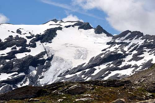
Rather popular Summit by skiers-mountaineers (a lot of people French by "ski de randonnée") along the SE Slope, perhaps coupling with descent on NE Slope in the opposite direction; crossing like this both Southern and Northern Arguerey Glaciers. That splendid window commands a view over the Breuil Valley (from Bassa Serra Western and Eastern Pass at beginning near Verney Lake and Litte Saint Bernard Pass), with of Glacier Arguerey (2.436/2.528m, level route on lower basin, abounding in waters), Tormotta(z) Lakes (2.486m; double and more large) and Verney Doire (= Verney Great Torrent). Third Summit for height, between Little Saint Bernard Pass (2.189m) in South southeast and Seigne Pass (2.514m) in Northnorthwest, after Léchaud Point (3.128m) and The Fourclaz-Ouillons Point (3.112m). Sited on frontier Italian/French crest, expose two glaciers (Arguerey Southern and Northern) in first slope, whereas to French descend a slope before rocky, after debris upon tiny La Platte Lake. Fine views frontally in North to Mount Blanc Mountain Chain and in the distance to Southeast toward entire Rutor Group and Great Sassière; to S-SW good at a glance on nearby Mount Pourri and Great Motte/Casse. As far as the eye can see into whole Southeastern Graians Alps.
Cima piuttosto frequentata dagli sci-alpinisti (molto da parte dei francesi in ski de randonnée) lungo il Versante SE, abbinandola magari con la discesa sull'opposto NE e percorrendone così entrambi i Ghiacciai Meridionale e Settentrionale di Arguerey. In questo modo dominando dall'alto di questa splendida finestra tutto il Vallone del Breuil (dai Colli Occidentale ed Orientale della Bassa Serra sino al suo imbocco presso il Lago Verney ed il Passo del Piccolo San Bernardo), nonché gli omonimi laghi (siti tra le quote di 2.436/2.428 m nel sottostante bacino ricchissimo d'acque) e quelli doppi e più estesi della Tormotta(z) (2.486 m), originanti la Doire de Verney. Terza cima per elevazione, tra il Colle del Piccolo San Bernardo (2.189 m) a S ed il Col de la Seigne (2.514 m) a N, dopo la Punta Léchaud (3.128 m) e La Fourclaz-Pointe des Ouillons (3.112 m). Situata sulla cresta di frontiera italo/francese, presenta due ghiacciai (di Arguerey Meridionale a Settentrionale) sul primo versante, mentre su quello rivolto alla Francia lascia cadere un versante prima roccioso, poi detritico incombente sul minuscolo laghetto di La Platte. Belle viste frontalmente a N sulla vicina Catena del Monte Bianco ed in lontananza verso SE sull'intero Gruppo del Rutor e sulla Grande Sassière; verso S-SW bei colpi d'occhio sul vicino Mont Pourri nonché su Grande Motte e Grande Casse. A perdita d'occhio sulle Alpi Graie Sudorientali.
First Ascents
- First on the summit: Abbot of Litte Saint Bernard Pierre Chanoux, (Summer 1870).
- SE Slope from Arguerey Glacier: Abbot Pierre Chanoux, (Summer 1870).
- In winter: Unknown.
- GREAT TRAVERSE from Chavannes Pass (2.603m) to Chavannes Pass: Léchaud Mount (2.805m) – Quota 2.956m, 3.000m, 3.061m – Léchaud Point (3.127m) – Petit Léchaud (2.973m) La Fourclaz or Ouillons Point (NW 3.112m, Central 3.090m, SE 3.061m) - Breuil Pass (2.882m) – Quota 3.008m – Miravidi Mount (3.068m) – Veys Pass (2.984m) – Glaciers Point (3.023m) – Western Bassa Serra Pass (2.900m) – Glacier of Chavannes Lakes (2.713m, 2.631m) – Chavannes Pass; Osvaldo Cardellina and Giuseppe Lamazzi (integral); Marco Cossard, Raffaella Pellizzari and Sandro Plat (leaving out La Fourclaz three Summits), (Sep 28th, 1980), in day from Chavannes Valley.
Getting There
BY CAR:- From the Morgex exit of Motorway A5 (921m), continue for about 3 km on SS.26 towards Pré Saint Didier (1017m). SS.26 becomes the main street of the small city and then continues toward Colle del Piccolo San Bernardo (2.188m). After several hairpins, and past the Villages of Elevaz (1.302m) and la Balme (1.309m) reach the famous ski resort of La Thuile (1.441m). Turn left on the bridge that crosses "Dora di La Thuile", a go on along the same road continue to rise along the SS.26, which leads to the Piccolo San Bernardo Pass to Lake Verney (2.088m) just below the pass.
- Dall'uscita dell'Autostrada A5 nel comune di Morgex (921 m) proseguire per circa 3 km lungo la SS.26 verso il Paese di Pré Saint Didier (1.017 m), addentrarsi nella via centrale del paese e proseguire sempre lungo la SS.26 che porta al Colle del Piccolo San Bernardo (2.188 m). Dopo numerosi tornanti e superate le Frazioni di Elevaz (1.302 m) e la Balme (1.309 m) si giunge alla famosa località sciistica di La Thuile (1.441 m). Svoltare a destra sul ponte che attraversa la "Dora di La Thuile", continuare a salire lungo la SS.26 che conduce al Colle de Piccolo San Bernardo fino al Lago di Verney (2.088 m) sito appena sotto il colle.
BY PLANE:
- Aeroporto "Corrado Gex" Saint Christophe (Aosta).

Route
From parking (2.098m), near the Verney Lake (2.088m), by Northwest direction and groundroad to descend briefly to of same effluent (Lake Torrent) in quota 2.079m; in fork of same (continued in Northeast toward nearby Lechepré Pasture, 2.017m) with other three paths, to choose the first in left and, by before SW direction, after North to reach the Higher Verney Lake (2.280m). Tourning in right (East) and passing between the same and a tiny lake to arrive at a cross with principal path, in the junction of two small torrents. Continue in Northnortheast to Torvéraz Alp (variant), also, always by the same and NW direction, to small basin, with little lake, sited below S Slopes of small, but smart, Red Point (2.659m); to go up higher "colletto" (= small and round pass), straight away in West of same (2.551m). To like this "penetrate" into Tormotta(z) Vallon (=great alpine valley), forwarded the Breuil, true and own; leaving in left (West) two of Red Point minilakes to reach the effluent in quota 2.490m~, to be transformed the same, immediately afterwards, the tributary of more important following Tormotta two Lakes (2.486m the major), below of typical "great bread" Tormotta Point (2.686m). To wade across, non always easily (above all in evening return for considerable of waters a rise) getting in gravely tableland, amongst various lakes; by North direction and scarce traces to join with Arguerey Torrent, encircled by numerous and with the same name small lakes, in quota 2.436m. Continue in W-NW and between the Torrents of Glacier Arguerey Lake, in North, and of Southern Arguerey Glacier, in South.; to go up laboriously, and without trace, through debris and moraines in non excessive slope, reaching the Lower Arguerey Lake (2.678m). By Westnorthwest direction go up by moraine or snowfields, beyond a between two rocky strips narrowing in quota 2.725/50 m, and to join near a tiny lake at beginning of Southern Arguerey Glacier, in quota 2.910/15m~. To cross, same direction, and, through snowy SE Slope (much suitable for ski-mountaineering), with fatigue, to climb Summit (3.068m; 3h'00/3h'30).Dal parcheggio (2.098 m), presso il Lago di Verney (2.088 m), con direzione NW e strada poderale scendere brevemente verso l'emissario dello stesso (Torrent du Lac) a quota 2.079 m; all'incrocio della stessa (che continua a NE verso la vicina Alpe Lechepré; 2.017 m) con altri tre sentieri, prendere il primo di sinistra e, con direzione prima SW e poi N, raggiungere il Lac de Verney Dessous (2.280 m). Aggirandolo sulla destra (E) e transitando in mezzo tra lo stesso ed un minuscolo laghetto, pervenire all'incrocio con il sentiero principale, vicino alla congiunzione di due torrentelli. Continuare verso N-NE verso l'Alpe di Torvéraz (variante), oppure sempre con lo stesso, e con direzione NW, verso il piccolo bacino con laghetto posto alle pendici S della piccola, ma elegante, Pointe Rouge (2.659 m); risalire al soprastante colletto, subito ad W della stessa (2.551 m). Entrare così nel Vallone della Tormotta(z), anticipatorio a quello vero e proprio del Breuil; lasciando a sinistra (W) i due minilaghetti de la Pointe Rousse, raggiungerne l'emissario a quota 2.490 m~, divenendo lo stesso, subito dopo, immissario dei ben più importanti Laghi della Tormotta (2.486 m il maggiore), ai piedi del caratteristico "panettone" della Punta Tormotta (2.686 m). Guadare, non sempre facilmente (soprattutto al ritorno serale per il notevole aumento delle acque) entrando nel ghiaioso altipiano tra i laghi; con direzione N e scarse tracce raggiungere il Torrente di Arguerey, circondato dai numerosi ed omonimi laghetti, a quota 2.436 m Proseguire verso W-NW ed in mezzo ai Torrenti dei Lacs du Glacier d'Arguerey, a N, e del Glacier Meridional d'Arguerey, a S; salire faticosamente, e senza traccia, per detriti e morene in non eccessiva pendenza, raggiungendo il Lago Inferiore di Arguerey (2.678 m). Con direzione W-NW indirizzarsi su morena o nevati, oltrepassando una strettoia tra due fasce rocciose a quota 2.725/50 m, e pervenire presso un minuscolo laghetto all'inizio del Ghiacciaio Meridionale di Arguerey, a quota 2.910/15 m~. Percorrerlo, stessa direzione, e, tramite l'innevato versante SE (molto adatto allo sci-alpinismo), facilmente, raggiungere la Vetta (3.068 m; 3h'00/3h'30).
Variant
VARIANT: from of Lower Arguerey Glacier (2.678m) go up briefly by rubbles and morainic land to Higher Lake (2.725m); by Northwest direction, moraine and moderate slope in of glacier Southwest border, easily to join the Veys Pass (2.984m). From pass, at full speed, to cross the short and small S-SE Crest to Summit (same timetable; better to combine this route in ascent, with descent by preceding, especially for ski-mountaineering).VARIANTE: Dal Lac du Glacier d'Arguerey Inferiore (2.678 m) risalire brevemente su frantumi e terreno morenico a quello Superiore (2.725 m); con direzione NW, morena e moderata pendenza, nel bordo SW del ghiacciaio, facilmente raggiungere il Col des Veys (2.984 m). Dal colle percorrere velocemente la crestina S-SE sino alla Vetta (stesso orario; meglio combinare questo itinerario in salita, con discesa tramite il precedente, soprattutto in sci-alpinismo).
Difficulty
This route can be considered EE/F. BSA for ski-mountaineering.L'itinerario è classificato EE/F. BSA per lo Sci Alpinismo.
 |
 |
 |
 |
 |
Equipment for the Route
Standard mountaineering equipment.Campings
Remember that free camping is forbidden (except for emergency reasons, over 2.500m, from darkness until dawn).Mountain Conditions
- You can get meteo information at the official site of the Regione Valle d'Aosta:
- Valle d'Aosta Meteo
- Meteo: You can find more weather information on the website 3B Meteo:
- Meteo Colle del Piccolo San Bernardo
Webcam
- WEBCAM on Aosta Valley:
- Webcam
Books and Maps
BOOKS:- "Guida dei Monti d'Italia–Alpi Graie Centrali", di Alessandro Giorgetta - Club Alpino Italiano/Touring Club Italiano, 1985 (in Italian).
- "Guida delle Alpi Occidentali", di Giovanni Bobba e Luigi Vaccarone C.A.I. Sezione di Torino Volume II (parte II), 25 Maggio 1896.
- "Valdigne gli itinerari escursionistici", di Alessandro Giorgetta, Ed. Zanichelli, Giugno 1981.
- "Diari Alpinistici" di Osvaldo Cardellina e Indice Generale accompagnato da Schedario Relazioni Ascensioni 1964-2019 (inediti).
 |
 |
 |
MAPS:
- Kompass "Gran Paradiso Valle d'Aosta Sentieri e Rifugi" Carta turistica 1:50.000.
- L'Escursionista "La Thuile-Piccolo San Bernardo" (carta n° 2) 1:25.000.
- A.I.A.T. La Thuile, "La Thuile Pianta dei Sentieri", 2004 (Plastico).
- Carta Comunità Montana "Valdigne e Mont Blanc Les Sentiers", 2001 1:50.000.
- L’Escursionista "Monte Bianco Courmayeur Carta dei Sentieri" (n° 1) 1:25.000.
- I.G.C. Istituto Geografico Centrale Torino "Monte Bianco-Courmayeur-Chamonix-La Thuile" (carta n° 107), 1:25.000.
Important Information
- REGIONE AUTONOMA VALLE D'AOSTA the official site.
- FONDAZIONE MONTAGNA SICURA Villa Cameron, località Villard de la Palud n° 1 Courmayeur (AO) Tel: 39 0165 897602 - Fax: 39 0165 897647.
- Società Guide Alpine Courmayeur www.Guidecourmayeur.com - Strada Villair n° 2 - 11013 Courmayeur (Aosta) Italy - Tel. +390165842064 Fax. +390165842357 - P.I. 01022640070
- COMPAGNIE DES GUIDES RUTOR Fraz. Entrèves tel/fax 0039.0165.885574 e-mail Guidealpine@lathuile.it
- A.I.NE.VA. (Associazione Interregionale Neve e Valanghe).
Useful numbers
- Protezione Civile Valdostana località Aeroporto n° 7/A Saint Christophe (Ao) Tel. 0165-238222.
- Bollettino Meteo (weather info) Tel. 0165-44113.
- Unità Operativa di Soccorso Sanitario Tel. 118.