Stings to if and detached toward East from the neighbor Mount Miravidi (3.068m) of which constitutes a great shoulder projected to East of it, where, after the maximum elevation (3.023m) it falls with a great slope rocky-debris in direction of the Lacs du Glacier of Arguerey (2.528m, the most elevated toward North and 2.436 meters that lower than it is undoubled in two small and separate small lakes crossing the Torrent of Arguerey) in the middle walloon of the Breuil, immediately after the splendid Lakes of the Tormotta. Mail among the two Glaciers Northern and Southern of Arguerey is easily stung attainable from the small saddle 2.990/5 meters sited among the two points; the same one is directly attainable from the two opposite slopes North and South, or with a brief crossing originating from the Necks of the Breuil (2.882m) Northwestern or of the Veys (2.984m) to West-southwest. Generally not slope as primary objective, but rather frequented joining it to the slope of the Mont Miravidi pleasant trip of ski-mountaineering and good person it results "excursion raced" with departure always from the near of the Hill of the Little Saint Bernard (2.202m) or, dark and practically, from the parking lot (2.098m) near the Inferior Lac Verney (2.088m). It allows beautiful crossings with his slope the conclusive phase being departing from the Hill of Arguerey (2.846m) and climbing over therefore the Aiguille Veys (3.024m), the homonym Pass (2.984m) and the Mount Miravidi, both from the Col du Breuil (2.882m) always going beyond the Miravidi. But the "daily trekking" more interesting he is constituted by the great crossing (you see "First Ascent"), practicable from the Pass of Chevannes (2.603m) and climbing in succession the Mont Lechaud (2.805m) up to the quota 2.956 meters; from this, along the crest of border, climbed to the Point Lechaud (3.127m; maximum elevation among the Pass of the Little St. Bernard and the Seigne Pass, crossed to the three tops of the Pointe des Ouillons or otherwise said La Fourclaz, descent to With du Breuil and slope to the Miravidi to conclude the tour with the Point of the Glaciers. From his Top it enjoys too far not him of a beautiful sight on the Southern Slope of the Mount Blanc as far as to Great Jorasses, as well as of beautiful glimpses on all the lakes of the long "Vallone" of the Breuil and on all the peaks of the chain of border among Italy and France from the Lancebranlette Peak (2.927m) to South near the Pass of the "Piccolo" one and up to the Point North Léchaud (3.127m), which the most elevated and important results on the crest of frontier before the Col de la Seigne (2.514m) where, finishing the Central Graian Alps, it begins the great Chain of the Monte Bianco.
Punta a se stante e distaccata verso Est dal vicino Mont Miravidi (3.068 m), del quale ne costituisce una grande spalla proiettata ad Oriente, dove, dopo la massima elevazione (3.023 m) cade precipite con un grande versante roccioso-detritico in direzione dei Lacs du Glacier d'Arguerey (2.528 metri il più elevato verso Settentrione e 2.436 metri quello più basso sdoppiantesi in due piccoli e distinti laghetti incrociando il Torrent d'Arguerey) nel medio Vallone del Breuil, subito dopo i bei Laghi della Tormotta. Posta tra i due Ghiacciai Settentrionale e Meridionale di Arguerey, è punta facilmente raggiungibile dalla piccola sella 2.990/5 metri sita tra le due vette; la stessa è raggiungibile direttamente dai due opposti versanti Nord e Sud, oppure con una breve traversata provenendo dai Colli del Breuil (2.882 m) a Nordovest o del Veys (2.984 m) ad Ovest-sudovest. In genere non salita come obiettivo primario, bensì piuttosto frequentata accoppiandola ed abbinandola alla salita del Mont Miravidi, risulta piacevole gita di sci-alpinismo e buona "corsa" escursionistica con partenza sempre dai pressi del Colle del Piccolo San Bernardo (2.202 m) oppure, e più praticamente, dal parcheggio (2.098 m) presso il Lac Verney Inferiore (2.088 m). Risulta esser una bella e classica traversata, nella sua fase conclusiva, sia partendo dal Colle d'Arguerey (2.846 m), dopo aver oltrepassato l'Aiguille Veys (3.024 m), l'omonimo Passo (2.984 m), nonché il Monte Miravidi; sia provenendo dal Col del Breuil (2.882 m) e pur sempre scavalcaldo il Miravidi. Ma il "trekking giornaliero" sicuramente più interessante praticabile é certamente costituito (da vedersi in "First Ascent"), da quello con partenza dal Col des Chevannes (2.603 m), nell'omonimo vallone, con superamento in successione del Mont Léchaud (2.805 m) insino alla quota 2.956 metri; da questa, seguendo la cresta di confine, salita alla Pointe Léchaud (3.127 m; massima elevazione tra il Colle del Piccolo San Bernardo ed il Col de la Seigne), attraversanso le tre sommità della Pointe des Ouillons pur conosciuta come La Fourclaz, discesa al Colle del Breuil e risalita al Miravidi e, per finire in bellezza, concludendo il giro con la Pointe des Glaciers. Dalla sua Cima si gode di una bella vista sul non troppo lontano versante Meridionale del Monte Bianco insino alle Grandes Jorasses, nonché di bei colpi d'occhio su tutti i laghi del lungo Vallone del Breuil e su tutte le vette della catena di confine tra Italia e Francia dalla aguzza Lancebranlette (2.927 m) a Sud presso il Colle del Piccolo e fino alla Punta Léchaud a Settentrione (3.127 m), la quale risulta la più elevata ed importante sulla cresta di frontiera prima del Col de la Seigne (2.514 m) dove, terminando le Alpi Graie Centrali, inizia la grande Catena del Monte Bianco.
First Ascents
First on the summit: Unknown.
In winter: Unknown.
GREAT TRAVERSE from Chavannes Pass (2.603m) to Chavannes Pass: Léchaud Mount (2.805m) – Quota 2.956m, 3.000m, 3.061m – Léchaud Point (3.127m)– Petit Léchaud (2.973m)La Fourclaz or Ouillons Point (NW 3.112m, Central 3.090m, SE 3.061m) - Breuil Pass (2.882m) – Quota 3.008m – Miravidi Mount (3.068m) – Veys Pass (2.984m) – Glaciers Point (3.023m)– Western Bassa Serra Pass (2.900m) – Glacier of Chavannes Lakes (2.713m, 2.631m) – Chavannes Pass; Osvaldo Cardellina and Giuseppe Lamazzi (integral); Marco Cossard, Raffaella Pellizzari and Sandro Plat (leaving out La Fourclaz's three Summits), (Sep 28th, 1980), in day from Chavannes Valley.
Getting There
BY CAR:
From the Morgex exit of Motorway A5 (921m), continue for about 3 km on SS.26 towards Pré Saint Didier (1.017m). SS n° 26 becomes the main street of the small city and then continues toward Colle del Piccolo San Bernardo (2.188m). After several hairpins, and past the Villages of Elevaz (1.302m) and la Balme (1.309m) reach the famous ski resort of La Thuile (1.441m). Turn left on the bridge that crosses "Dora di La Thuile", a go on along the same road continue to rise along the SS.26, which leads to the Piccolo San Bernardo Pass to Lake Verney (2.088m) just below the very famous and ancient pass.
IN AUTO:
Dall'uscita dell'Autostrada A5 nel comune di Morgex (921 m) proseguire per circa 3 km lungo la SS.26 verso il Paese di Pré Saint Didier (1.017 m), addentrarsi nella via centrale del paese e proseguire sempre lungo la SS.26 che porta al Colle del Piccolo San Bernardo (2.188 m). Dopo numerosi tornanti e superate le Frazioni di Elevaz (1.302 m) e la Balme (1.309 m) giungesi alla famosa località sciistica di La Thuile (1.441 m). Svoltare a destra sul ponte che attraversa la "Dora di La Thuile", continuare a salire lungo la SS.26 che conduce al Colle de Piccolo San Bernardo fino al Lago di Verney (2.088 m) sito appena sotto il famosissimo ed antico colle.
BY PLANE:
Aeroporto "Corrado Gex" Saint Christophe (Aosta).
Approach and Route A
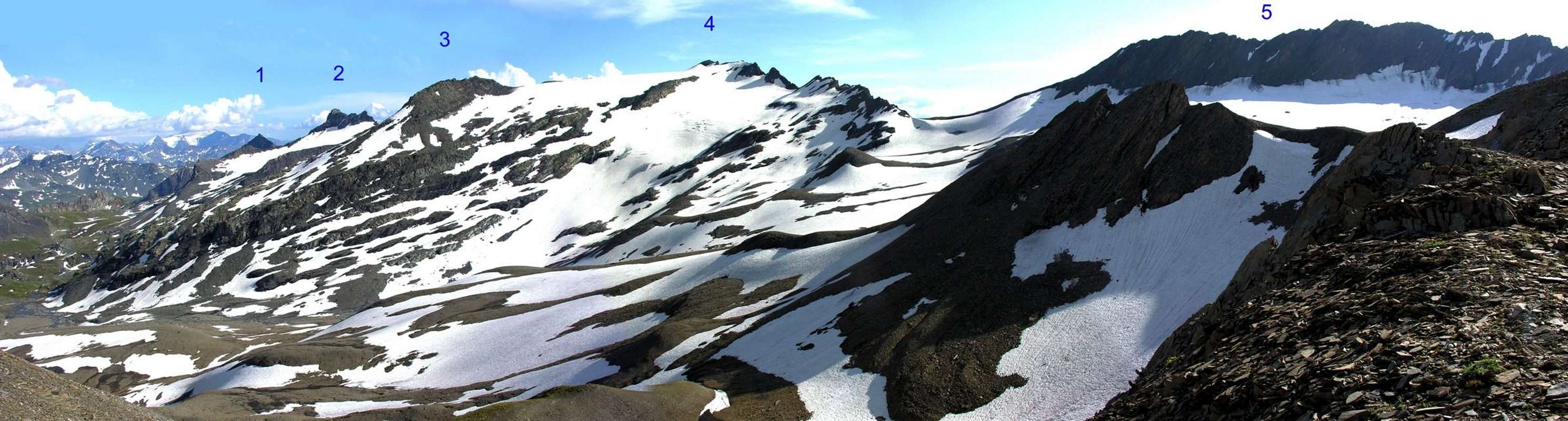
From parking (2.098m), near the Verney Lake (2.088m), by Northwest direction and groundroad to descend briefly to of same effluent (Lake Torrent) in quota 2.079m; in fork of same (continued in Northeast toward nearby Lechepré Pasture, 2.017m) with other three paths (all not numbered), to choose the first in left and, by before Southwest direction, after North to reach the Higher Verney Lake (2.280m). Tourning in right (East) and passing between the same and a tiny lake to arrive at a cross with principal path, in the junction of two small torrents. Continue in North-northeast to Torvéraz Alp (variant of trail), also, always by the same and Northwest direction, to small basin, with little lake, sited below Southern Slopes of small, but smart and precisely reddish, Red Point (2.659m); to go up higher "colletto" (= small and round pass or collar), straight away in West of same (2.551m). To like this "penetrate" into Tormotta(also Tormottaz) walloon (= great alpine valley), forwarded the Breuil, true and own; leaving in left (West) two of Red Point minilakes to reach the effluent in quota 2.490m~, to be transformed the same, immediately afterwards, the tributary of more important following Tormotta two Lakes (2.486m the major), below of typical "great bread" Tormotta Point (2.686m). To wade across, non always easily (above all in evening return for considerable, to great surprise, of waters a rise) getting in gravely tableland, amongst various lakes; by North direction and scarce traces to join with Arguerey Torrent, encircled by numerous and with the same name small lakes, in quota 2.436m. Continue in West-northwest and between the Torrents of Glacier Arguerey Lake, in North, and of Southern Arguerey Glacier, in South.; to go up laboriously, and without trace, through debris and moraines in non excessive slope, reaching the Lower Arguerey Lake (2.678m). By West-northwest direction go up by moraine or snowfields, beyond a between two rocky strips narrowing in quota 2.725/50 meters, and to join near a tiny lake at beginning of Southern Arguerey Glacier, in quota 2.910/15 m~. Same give, or as soon as before reaching it, to change direction toward North and, through hundred scarce meters and along an enough steep slant, to reach the small saddle 2.990/5 meters around sets among the Point of the Glaciers and the Mont Miravidi in West (3.068m); for easy small rocks and easily (I°), crossing his little, but more short, West Crest to reach the Peak after a first line as soon as steep, a second in light level route and a small "turret" final (3.023m; 3h'00/3h'15).
Dal parcheggio (2.098 m), presso il Lago di Verney (2.088 m), con direzione Nordovest e strada poderale scendere brevemente verso l'emissario dello stesso (Torrent du Lac) a quota 2.079 m; all'incrocio della stessa (che continua a Nordest verso la vicina Alpe Lechepré; 2.017 m) con altri tre sentieri (tutti non numerati), prendere il primo di sinistra e, con direzione prima Sudovest e poi Nord, raggiungere il Lac de Verney Dessous (2.280 m). Aggirandolo sulla destra (Est) e transitando in mezzo allo stesso ed un minuscolo laghetto, pervenire all'incrocio con il sentiero principale, vicino alla congiunzione di due torrentelli. Continuare verso Nord-nordest verso l'Alpe di Torvéraz (variante di percorso), oppure sempre con lo stesso, e con direzione Nordovest, verso il piccolo bacino con laghetto posto alle pendici Meridionali della piccola, ma elegante e per l'appunto nrossiccia, Pointe Rouge (2.659 m); risalire al soprastante colletto, subito ad Occidente della stessa (2.551 m). Entrare così nel Vallone della Tormotta(o Tormottaz), anticipatorio a quello vero e proprio del Breuil; lasciando a sinistra (Ovest) i due minilaghetti de la Pointe Rousse, raggiungerne l'emissario a quota 2.490 m~, divenendo lo stesso, subito dopo, immissario dei ben più importanti Laghi della Tormotta (2.486 m il maggiore), ai piedi del caratteristico "panettone" della Punta Tormotta (2.686 m). Guadare, non sempre facilmente (soprattutto al ritorno serale per il notevole aumento a sorpresa delle acque) entrando nel ghiaioso altipiano tra i laghi; con direzione Nord e scarse tracce raggiungere il Torrente di Arguerey, circondato dai numerosi ed omonimi laghetti, a quota 2.436 m. Proseguire verso Ovest-nordovest ed in mezzo ai Torrenti dei Lacs du Glacier d'Arguerey, a Settentrione, e del Glacier Meridional d'Arguerey, a Mezzogiorno; salire faticosamente, e senza traccia, per detriti e morene in non eccessiva pendenza, raggiungendo il Lago Inferiore di Arguerey (2.678 m). Con direzione Ovest-nordovest indirizzarsi su morena o nevati, oltrepassando una strettoia tra due fasce rocciose a quota 2.725/50 metri, e pervenire presso un minuscolo laghetto all'inizio del Ghiacciaio Meridionale di Arguerey, a quota 2.910/15 m~. Dallo stesso, oppure appena prima di raggiungerlo, cambiare direzione verso Nord e, tramite un centinaio di metri scarsi e lungo un pendio abbastanza ripido, raggiungere la piccola sella 2.990/5 m~ posta tra la Punta dei Ghiacciai ed il Mont Miravidi ad Occidente (3.068 m); per facili roccette e facilmente (I°), percorrendo la sua piccola, nonché alquanto breve Cresta Ovest, raggiungere la Vetta dopo un primo tratto appena più ripido, un secondo in leggero falsopiano ed una piccola "torretta" finale (3.023 m; 3h'00/3h'15).
Approach and Route B
From hairpin road (1.861m, small parking) SS.26 of La Thuile Tourist Village and Resort toward Little Saint Bernard Pass (2.002m), near the La Cretaz Alp (1.886m) on Plenty Tableland, by West-southwest direction, path n° 10 attendant with ground road, toward the Chaz (= alp) Pasture (1.975m) and, along Verney Torrent, go down briefly to little and typical Ponte di Pont (= bridge of Bridge; 1.838m) over the Torrent du Lac, place of origin the Veney Lake in Southwest and from Breuil Torrent, descending in Northwest. Before go up in West toward Chanté Alpage (1.993m), after in West-northwest, con ground road (short cut), to Plan Veyle (é) Pasture (2.080m; source), leaving in East (only just in right) the path n° 10B toward Laityre Mount (2.727m); continue, same direction, commanding a view over the Verney Doire (=Stream), from a height of hundred meters. Cross below the great rock known as Grand Berrier (= of valley Great Stone; 2.464m) and eight tiny torrents (various sources) descending from Ouille Mount (3.098m), progressing "soft" level route, in quota 2.300/30m~; this way rejoin the Entre-deux-Eaux Pasture (= Between Two Waters Alp; 2.333m; great waterfall, frontally, with water all of a sudden springing from and inside of rocky leap), leaving at once in right (West). By a half circular tour before in Northeast, after in West to reach the Crotti Alp (2.520m), sited on a good open space near a tiny torrent and with the portals, unusually, facing North; by West-southwest direction, doubling in left the Quota 2.669m, pass below typical rocky bands and immediately turn in Northwest. Cross a first small torrent, coming from little loch 2.638m at Eastern slopes of Fornet Point (3.070m), and a second descending from Quota 2.735m, continuing in right (East) of a third from Eastern Bassa Serra Pass or Col des Echelles des Chavannes (2.737m; defences). From this point and to the middle quota of 2.500 meters around, to abandon on the right the path n° 10 that salt with a long diagonal toward North-northwest to the footstep and to decidedly go himself toward West in direction of a minuscule lake (2.527m) to the confluence of various branches of the Doire (= Stream) de Verney; same direction, to go up again toward the entrance of the real Walloon of the Breuil to quota 2.670/80 meters around, where the moraines that originate from the Glacier du Breuil and from the Glacier Septentrional of Arguerey they form an inclusive narrow passage among the quota 2.639 meters to Northern and an edge, a little accented, among the Slopes Northern and Oriental of the Point of the Glaciers. With to breadth turn to semicircle on the Glacier of Arguerey, after having gone beyond an easy and brief rocky band managing himself a few in the search of the good passage, to go up again to the little saddle-collar 2.990/5 meters around concluding briefly along the West Crest, as for the Route A (3h'30/3h'45).
Dal tornante (1.861 m piccolo parcheggio) della SS.26 di La Thuile per il Colle del Piccolo San Bernardo (2.002 m), presso l'Alpe La Cretaz (1.886 m) nel Piano dell'Abbondanza, con direzione Ovest-sudovest, sentiero n° 10 concomitante con la strada poderale, verso la Chaz Pontaille (1.975 m) e, lungo il Torrente Verney, scendere brevemente al piccolo e caratteristico Ponte di Pont (1.838 m) sul Torrent du Lac, proveniente dal Lac Verney a Sudovest e dal Torrent Breuil a Nordovest. Risalire prima ad Ovest verso l'Alpeggio Chanté (1.993 m) e poi a Ovest-nordovest, in concomitanza con la strada interpoderale (scorciatoia), verso l'Alpe Plan Veyle (è) (2.080 m; sorgente), lasciando poco prima sulla destra (Est) il sentiero n° 10B per il Mont Laityre (2.727 m); proseguire con la stessa direzione dominando da un centinaio di metri la Doire de Verney. Oltrepassare da sotto il roccione detto Grand Berrier (2.464 m) ed otto torrentelli (sorgenti) provenienti dal Monte Ouille (3.098 m), progredendo leggermente alla quota di 2.300/2.330 m~; raggiungere così l'Alpeggio di Entre-deux-Eaux (2.333 m; gran cascata frontalmente con l'acqua sgorgante d'improvviso e all'interno di un alto salto roccioso), che si lascia subito a sinistra (Ovest). Con un giro semicircolare prima a Nordest, poi ad Ovest si perviene all'Alpe Crotti (2.520 m), posta in una bella spianata presso un piccolo torrente e con le porte, atipicamente, rivolte verso Settentrione; con direzione Ovest-sudovest si doppia a sinistra la Quota 2.669 m, passando al di sotto di caratteristiche fasce rocciose, per poi bruscamente svoltare a Nordovest. Attraversare un primo torrentello, proveniente dal laghetto (2.638 m) alle pendici occidentali della Pointe du Fornet (3.070 m), ed un successivo proveniente dalla Quota 2.735 m, continuando a destra (Est) di un terzo scendente da sotto il Colle Orientale di Bassa Serra o Col des Echelles des Chavannes (2.737 m; fortificazioni). Da questo punto ed alla quota media di 2.500 metri circa, abbandonare sulla destra il sentiero n° 10, risalente con un lungo diagonale verso Nord-nordovest al passo, e portarsi decisamente verso Ovest in direzione di un minuscolo laghetto (2.527 m) alla confluenza di vari rametti della Doire de Verney; stessa direzione, risalire verso l'imbocco del vero e proprio Vallone del Breuil a quota 2.670/80 metri circa, ove le morene provenienti dal Glacier du Breuil e dal Glacier Septentrional d'Arguerey formano una strettoia compresa tra la quota 2.639 metri a Nord ed uno spigolo, scarsamente accentuato, tra i Versanti Settentrionale ed Orientale della Punta dei Ghiacciai. Con un largo giro a semicerchio sul Ghiacciao d'Arguerey, dopo aver oltrepassato una facile e breve banconata rocciosa destreggiandosi un pò nella ricerca del miglior passaggio, risalire alla selletta-colletto 2.990/5 m~ concludendo lungo la Cresta Ovest, come per la Route A (3h'30/3h'45).
For the ski-mountaineering
As it regards the ski-mountaineering there is to observe that the trip, as already says for the touring, he remains always also connected to the slope of the Miravidi Mountain. To the necessity dangerousness are underlined in the respect of snowslides and avalanches, in all respect as for every type of ski-alpine trip, you also signal from Alexander Giorgetta in "Alpi Graie Centrali", Edition C.A.I./T.C.I. in the Necklace Guide Book Mountains of Italy, 1985, pages 371/2":... The danger of avalanches is limited to the underlying line the crest Lancebranlette-Fourclaz, immediately to avoid him after abundant snowfalls. ...". In effects the line of following approach should not introduce excessive risks, because beyond the narrow passage Aiguille del'Hermite/Pointe Rousse the walloon rather widens in direction of the Lakes of the Tormotta. Unadvisable, instead, the approach of the Route B, since the long diagonal toward Northwest of the path n° 10 in direction of the Crotti Pasture is notably exposed to the possibility of fallen by the coastline Grand Berrier-Punta of Laityre-Mount Ouille-Pointe du Fornet; for the what thing, wanting to climb along the Northern Slope, it is worthwhile to use the Approach thin A. To cross the little ponds 2.436 meters and, continuing with direction Northwest, to reach the two minuscule lakes to quota 2.528 meters. Without reaching the following mini little loch 2.527 meters, to turn to the left progressively doubling I glean it dividing the two East Slopes and North of the mountain rejoining himself to the precedent itinerary of the Route B (Gradient 1.200 meters with exposure and East-southeast and then West-southwest for the Route A and North-northeast in the final part of the Route B; itinerary BS or for good skiers; period had recommended since April to end June; from the 4h'00 at 5h'00).
Per quanto concerne lo sci-alpinismo v'é da osservare che la gita, come già detto per l'escursionismo, rimane pur sempre collegata alla salita del Monte Miravidi. All'uopo si evidenziano le pericolosità nei cofronti di slavine e valanghe, daltronde come per ogni tipo di gita sci-alpinistica, segnalate pure da Alessandro Giorgetta in "Alpi Graie Centrali", Edizione C.A.I./T.C.I. nella Collana Guida dei Monti d'Italia, 1985, pagine 371/2: "... Il pericolo di valanghe é limitato al tratto sottostante la cresta Lancebranlette-Fourclaz, da evitarsi subito dopo abbondanti nevicate. ...". In effetti il tratto di avvicinamento susseguente non dovrebbe presentare rischi eccessivi, perché al di là della strettoia Aiguille del'Hermite/Pointe Rousse il vallone si allarga alquanto in direzione dei Laghi della Tormotta. Sconsigliabile, invece, l'avvicinamento della Route B, poiché il lungo diagonale verso Nordovest del sentiero n° 10 in direzione dell'Alpeggio Crotti é notevolmente esposto alla possibilità di cadute dalla costiera Grand Berrier-Punta di Laityre-Monte Ouille-Pointe du Fornet; per la qual cosa, volendo salire lungo il Versante Settentrionale, conviene utilizzare l'Approach A fino ad incrociare i laghetti 2.436 metri e, proseguendo con direzione Nordovest, raggiungere i due minuscoli laghi a quota 2528 metri. Senza toccare il successivo mini laghetto 2.527 metri, svoltare progressivamente a sinistra doppiando lo spigolo divisorio i due Versanti Est e Nord della montagna ricongiungendosi al precedente itinerario della Route B (Dislivello 1.200 metri con esposizione ed Est-sudest e poi Ovest-sudovest per la Route A e Nord-nordest nella parte finale della Route B (itinerario BS ovvero per buoni sciatori; periodo consigliato da Aprile a fine Giugno; dalle 4h'00 alle 5h'00).
Difficulty
This route can be considered EE/F. BS for ski-mountaineering and EE/F for the Mountaineering.
L'itinerario è classificato EE/F. BS per lo Sci Alpinismo ed EE/F per l'Alpinismo.
Equipment
Standard mountaineering equipment.
Campings
Remember that free camping is forbidden (except for emergency reasons, over 2.500m, from darkness until dawn).
Mountain Conditions
You can get meteo information at the official site of the Regione Valle d'Aosta:
Parents refers to a larger category under which an object falls. For example, theAconcagua mountain page has the 'Aconcagua Group' and the 'Seven Summits' asparents and is a parent itself to many routes, photos, and Trip Reports.

 6067 Hits
 84.27% Score
 18 Votes