
-
 5293 Hits
-
 87.76% Score
-
 25 Votes
|
|
Mountain/Rock |
|---|---|
|
|
45.70930°N / 6.85787°E |
|
|
Mountaineering |
|
|
8812 ft / 2686 m |
|
|
Overview
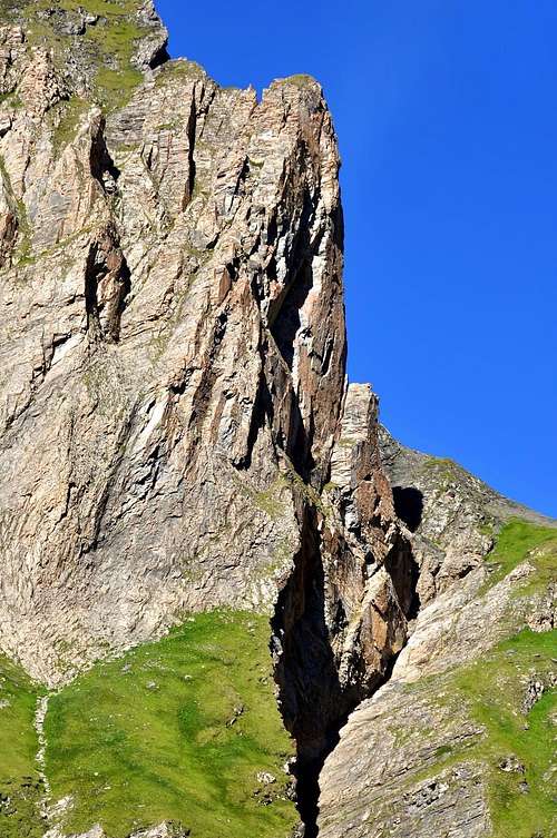
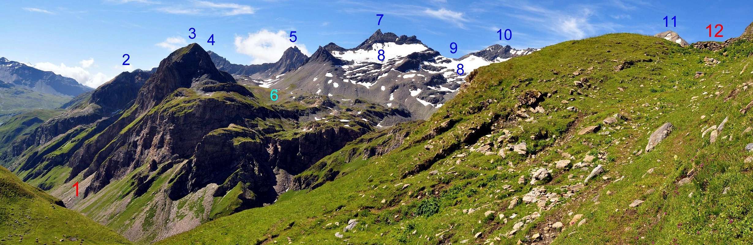
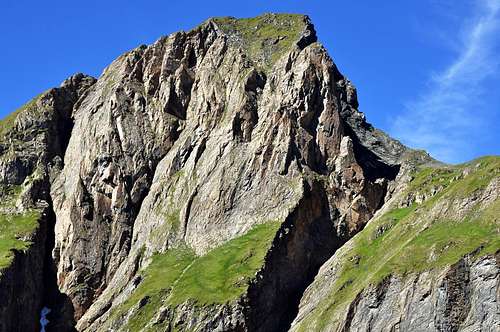
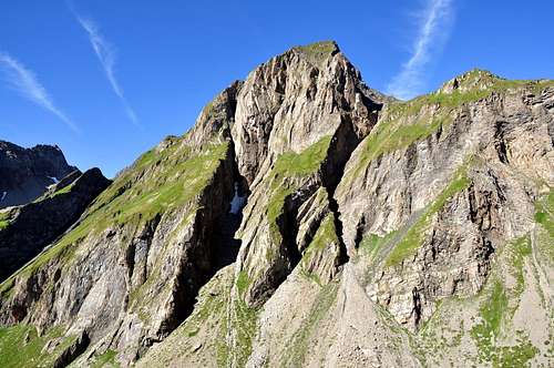
Round mountain, in the shape of "great bread", non much high, but with big and large mass, sited into a small buttress between Tormotta(z) (West) and Breuil (east) Valley, reunited at once after the same opening in the shape of fan range amongst Arguerey Torrent, D'Entre-Deux-Sauts Waterfall, Verneys Doire (= Great Torrent) and Bassas Serra Torrent in quota 2.500 m~. Easy excursion by S Crest also along the W Slope, up the two with same name lakes. On the contrary to let oneself down in Southeast, East but, above all, in Northeast (great wall, with edges and a pillar more than 500 meters high) steep walls with poor and mediocre rock (by analysis from high and from Summit), in spite of from bottom good to all appearance. Fair views in the distance to Monte Bianco Mountain Chain in North and to Rutor Group and its wide and extensive glaciers in South, but that is still circumscribed in W by Frontier Lancebranlette/Miravidi Mount/Léchaud Point Mountain Chain reason, in East nearby Laityre-Monte Ouille-Punta del Fernet Buttress motive. Locking down wonderful quick glances to numerous, many and large small lakes and various little torrents, in of waters abounding area.
Montagna tondeggiante a guisa di "panettone", non molto alta, ma dalla grande massa e posta in un piccolo contrafforte a cavallo tra i Valloni della Tormotta (W) e del Breuil (E) che si riuniscono proprio dopo lo stesso a quota 2.500 metri~ aprendosi a ventaglio tra il Torrent d'Arguerey, la Cascata D'Entre-Deux-Sauts, la Doire de Verney ed il Torrent de Bassa Serra. Facile escursione per la Cresta S oppure lungo il Versante O, soprastante gli omonimi laghi. Lascia cadere invece a SE, E ma, soprattutto, a NE (grande parete con spigoli e pilastro di oltre 500 metri) erte pareti di roccia mediocre (da un'analisi dall'alto e dalla vetta), nonostante la bell'apparenza dabbasso. Discrete viste in lontananza a N sulla Catena del Monte Bianco ed a S sul Gruppo del Rutor ed i suoi larghi ed estesi ghiacciai, ma circoscritte ad W dalla Catena di frontiera Lancebranlette/Monte Miravidi/Punta Léchaud ed a E dal vicino Contrafforte Laityre-Monte Ouille-Punta del Fernet. Guardando in basso bei colpi d'occhio sulla sottostante Vallata Tormotta/Breuil con tanti laghi e torrenti in un'area veramente ricca di acque.
First Ascents
- First on the summit: Unknown.
- In winter: Unknown.
Getting There
BY CAR:- From the Morgex exit of Motorway A5 (921m), continue for about 3 km on SS.26 towards Pré Saint Didier (1.017m). SS.26 becomes the main street of the small city and then continues toward Colle del Piccolo San Bernardo (2.188m). After several hairpins, and past the Villages of Elevaz (1.302m) and la Balme (1.309m) reach the famous ski resort of La Thuile (1.441m). Turn left on the bridge that crosses "Dora di La Thuile", a go on along the same road continue to rise along the SS.26, which leads to the Piccolo San Bernardo Pass to Lake Verney (2.088m) just below the pass.
- Dall'uscita dell'Autostrada A5 nel comune di Morgex (921 m) proseguire per circa 3 km lungo la SS.26 verso il Paese di Pré Saint Didier (1.017 m), addentrarsi nella via centrale del paese e proseguire sempre lungo la SS.26 che porta al Colle del Piccolo San Bernardo (2.188 m). Dopo numerosi tornanti e superate le Frazioni di Elevaz (1.302 m) e la Balme (1.309 m) si giunge alla famosa località sciistica di La Thuile (1.441 m). Svoltare a destra sul ponte che attraversa la "Dora di La Thuile", continuare a salire lungo la SS.26 che conduce al Colle de Piccolo San Bernardo fino al Lago di Verney (2.088 m) sito appena sotto il colle.
- Aeroporto "Corrado Gex" Saint Christophe (Aosta).
![]()
Approach of Route A
From parking 2.098m, near the Verney Lake (2.088m), by Northwest direction and groundroad to descend briefly to of same effluent (Lake Torrent) in quota 2.079m; in fork of same (continued in Northeast toward nearby Lechepré Pasture, 2.017m) with other three paths, to choose the first in left and, by before SW direction, after North to reach the Higher Verney Lake (2.280m). Tourning in right (East) and passing between the same and a tiny lake to arrive at a cross with principal path, in the junction of two small torrents. Continue in Northnortheast to Torvéraz Alp (variant), also, always by the same and NW direction, to small basin, with little lake, sited below S Slopes of small, but smart, Red Point (2.659m); to go up higher "colletto" (= small and round pass), straight away in West of same (2.551m). To like this "penetrate" into Tormotta(z)s Vallon (=great alpine valley), forwarded the Breuil, true and own.Dal parcheggio 2.098 m, presso il Lago di Verney (2.088 m), con direzione NW e strada poderale scendere brevemente verso l'emissario dello stesso (Torrent du Lac) a quota 2.079 m; all'incrocio della stessa (che continua a NE verso la vicina Alpe Lechepré; 2.017 m) con altri tre sentieri, prendere il primo di sinistra e, con direzione prima SW e poi N, raggiungere il Lac de Verney Dessous (2.280 m). Aggirandolo sulla destra (E) e transitando in mezzo tra lo stesso ed un minuscolo laghetto, pervenire all'incrocio con il sentiero principale, vicino alla congiunzione di due torrentelli. Continuare verso N-NE verso l'Alpe di Torvéraz (variante), oppure sempre con lo stesso, e con direzione NW, verso il piccolo bacino con laghetto posto alle pendici S della piccola, ma elegante, Pointe Rouge o Rousse (2.659 m); risalire al soprastante colletto, subito ad W della stessa (2.551 m). Entrare così nel Vallone della Tormotta(z), anticipatorio a quello vero e proprio del Breuil.
Route A
Leaving in left (West) two of Red Point mini lakes to reach the effluent in quota 2.490m~, to be transformed the same, immediately afterwards, the tributary of more important following Tormotta two Lakes (2.486m the major), below in West of typical "great bread" Punta Tormotta (2.686m). Gradually turn in right (East) and, through grassy slopes, to direct one's steps Quota 2.605m and easily reaching; continue in North direction on large and round South Crest, putting to Summit. From this great exposition in Northeast by a wall more than 500 meters high (F; E; 2h'30/2h'45). Descent: To cover in opposite and briefly the of crest first part for after go down in North, by grassy, debris and morenal slopes, to Tormotta Lakes (2.486m), worthy of visit; from these, before through a trace, after by path to "Colletto" (= Small Round Pass) 2.551m and of arrival same route.Lasciando a sinistra (W) i due minilaghetti de la Pointe Rousse, raggiungerne l’emissario a quota 2.490 m~, divenendo lo stesso, subito dopo, immissario dei ben più importanti Laghi della Tormotta (2.486 m) sottostanti ad W al "panettone" dell'omonima punta. Gradualmente girare a destra e, per pendii erbosi, indirizzarsi alla Quota 2.605 m raggiungendola facilmente; proseguire verso N sulla larga e tondeggiante Cresta Sud adducente alla Vetta, con grande esposizione a NE per una parete precipite di oltre 500 metri (F; E; 2h'30/2h'45). Discesa: Percorrere a ritroso ed in breve la prima parte di cresta per poi scendere a N, su pendii erbosi, detritici e morenici abbastanza ripidi, in direzione dei Laghi della Tormotta, che meritano una visita; da questi, dapprima su una traccia, indi per sentiero al "Colletto" 2.551 m ed alla via dell'andata.
 |
 |
 |
 |
|
Approach of Route B
Approach 1) - From parking 2.098m, near Verney Lake (2.088m), by Northwest direction and round road, briefly go down to effluent of Torrent Lake in quota 2.085m~, nearby a short of same branch. Leave the road and, through a small path in West, ford the torrent and border briefly the Verney Lake with Northern shore connecting with path from Little Saint Bernard. Go up 75/80m~ to North as far as the fork with path of Lechepré Pasture, leaving in right (East); instead continue in left and, by half circular route, reach Higher Verney Lake or Lac Dessus (2.280m; 0h'35).Approach 2) - From Little Saint Bernard Pass, near Roman Mansio (2.185m) go down in short by path to Verney Lake Southwest side; surround in Northwest connecting the preceding approach, from where begin go up in North (0h'45).
Approccio 1) - Dal parcheggio 2.098 m, presso il Lago di Verney (2.088 m), con direzione NW e strada poderale, scendere brevemente verso l'emissario del Torrent du Lac a quota 2.085 m~, presso una breve diramazione della stessa. Abbandonarla e con un sentierino verso O guadare il torrente e contornare il Lago Verney sulla sua sponda settentrionale per breve tratto ricongiungendosi al sentiero proveniente dal Piccolo San Bernardo. Risalire verso N per 75/80 m~ sino all'incrocio con il sentiero proveniente dall'Alpe Lechepré, lasciandolo sulla destra (E); continuare invece a sinistra e con percorso semicircolare giungere al Lago Verney Superiore o Dessus (2.280 m; 0h'35).
Approccio 2) - Dal Colle del Piccolo San Bernardo presso la Mansio Romana (2.185 m) scendere brevemente con sentiero verso la sponda SW del Lago Verney; contornarlo a NW ricongiungendosi al precedente avvicinamento, dove questo inizia a salire verso N (0h'45).
Route B
WESTERN WILD ROUTE: From Higher Verney Lake go up by grassy-debris slopes and "clapeys" (= blocks) on small valley in South along a little torrent, hardly dried, below Verney Crest (2.927m) and Lancebranlette Point (2.927m); joined of this last base under NE Wall, turn gradually in Northnorthwest going along the morenal amphitheatre between this and Bec (= hook-bill) of Rousses (2.937m), on rustic and wild environment and to rejoin at NE Spur base (2.595m), in quota 2.500m~ (source just further down, in quota 2.480m~, near a boulders; good "salle à manger"). Continuing level route in North, reach a second little torrent with same characteristics (source; more in low mini lake) and, going, by short difference in level, toward a third in small valley sited, between quotas 2.618m and 2.616m, giving more it a bit lower the tiny lake 2.402m. To cross by a distinctive rocks with ruddy/greenish plates to quota 2.616m (little and amusing climbing possibility) and, by easy descent in Northnortheast, briefly, reach the small lake below "Colletto" 2.551m, as well as the previous route (F; EE; 3h'15/3h'30).VIA "SELVAGGIA" OCCIDENTALE: Percorso quasi esclusivamente senza sentieri nella fase di andata in ambiente totalmente integro e solitario che si ricongiunge all'itinerario precedente al "Colletto" 2.551 m ad O della Pointe Rousse; da questi con la via precedente alla Punta della Tormotta. Dal Lago Verney Superiore risalire per pendii erboso detritici e "clapeys" un valloncello verso O lungo il solco di un torrentello, quasi essiccato, alle pendici della Cresta di Verney (2.927 m) e della Punta di Lancebranlette (2.927 m); giunti alla base della Parete NE di quest'ultima, volgere gradualmente verso N-NW percorrendo l'anfiteatro morenico tra questa ed il Bec des Rousses (2.937 m) in un ambiente rustico e pervenire alla base (2.595 m) dello sperone NE di quest'ultimo alla quota 2.500 m~ (sorgente appena più in basso a quota 2.480 m, vicino a grandi massi; ottima salle à manger). Continuando in quota verso N, raggiungere un secondo torrentello con le stesse caratteristiche (sorgente; più in basso mini laghetto) e, risalendo con piccola differenza di livello, verso un terzo sito in un valloncello tra le quote 2.618 m e 2.616 m, originante più in basso il laghetto (2.402 m). Attraversare su caratteristiche rocce a placche rosso/verdastre verso la quota 2.616 m (possibilità di piccole arrampicate; divertente) e, con breve e facile discesa verso N-NE, raggiungere il laghetto sottostante il "Colletto" 2.551 m, nonché la via precedente (F; EE; 3h'15/3h'30).
 |
 |
Difficulty
Easy anf for Experienced Hikers EE.Gear
Normal hiking equipment.Campings
Remember that free camping is forbidden (except for emergency reasons, over 2.500m, from darkness until dawn).Mountain Conditions
- You can get meteo information at the official site of the Regione Valle d'Aosta:
- Valle d'Aosta Meteo
- Meteo: You can find more weather information on the website 3B Meteo:
- Meteo Colle del Piccolo San Bernardo
Webcam
- WEBCAM on Aosta Valley:
- Webcam
Books and Maps
BOOKS:- "Guida dei Monti d'Italia–Alpi Graie Centrali", di Alessandro Giorgetta - Club Alpino Italiano/Touring Club Italiano, 1985 (in Italian).
- "Diari Alpinistici" di Osvaldo Cardellina e Indice Generale accompagnato da Schedario Relazioni Ascensioni 1964-2019 (inediti).
 |
 |
- L'Escursionista "La Thuile-Piccolo San Bernardo" (carta n° 2) 1:25.000.
- IGN Grenoble mont-blanc parc national de la vanoise (n° 53) 1:100.000.
- A.I.A.T. La Thuile, "La Thuile Pianta dei Sentieri", 2004 (Plastico).
- Carta Comunità Montana "Valdigne e Mont Blanc Les Sentiers", 2001 1:50.000.
- L'Escursionista "Monte Bianco Courmayeur Carta dei Sentieri" (n° 1) 1:25.000.
- I.G.C. Istituto Geografico Centrale Torino "Monte Bianco-Courmayeur-Chamonix-La Thuile" (carta n° 107), 1:25.000.
 |
 |
 |
Important Information
- REGIONE AUTONOMA VALLE D'AOSTA the official site.
- FONDAZIONE MONTAGNA SICURA Villa Cameron, località Villard de la Palud n° 1 Courmayeur (AO) Tel: 39 0165 897602 - Fax: 39 0165 897647.
- Società Guide Alpine Courmayeur www.Guidecourmayeur.com - Strada Villair n° 2 - 11013 Courmayeur (Aosta) Italy - Tel. +390165842064 Fax. +390165842357 - P.I. 01022640070
- COMPAGNIE DES GUIDES RUTOR Fraz. Entrèves tel/fax 0039.0165.885574 e-mail Guidealpine@lathuile.it
- A.I.NE.VA. (Associazione Interregionale Neve e Valanghe).
Useful numbers
- Protezione Civile Valdostana località Aeroporto n° 7/A Saint Christophe (Ao) Tel. 0165-238222.
- Bollettino Meteo (weather info) Tel. 0165-44113.
- Unità Operativa di Soccorso Sanitario Tel. 118.