
-
 3290 Hits
-
 86.37% Score
-
 22 Votes
|
|
Mountain/Rock |
|---|---|
|
|
45.75896°N / 6.93579°E |
|
|
Mountaineering |
|
|
9770 ft / 2978 m |
|
|
Overview
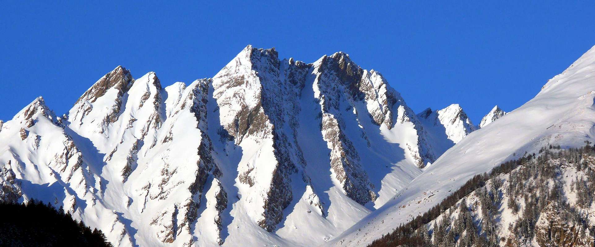
This mountain is part of the Group of Berio Mont Blanc (3.252m), located between the Vallons of Chavannes (West) and Orgères and perpendicular to the Valley of La Thuile. By the same branches off towards the North a buttress reaching the Mont Favre (2.967m), where the ridge splits: one branch goes down Westward to divide the first of the two small valleys above (inside the Valley of the Little St. Bernard) from the underlying Val Veny; the second, by bending to the East-northeast, is directed first towards the Mont Nix (2.919m) and then the next Testa d'Arp (2.747m). This forms a knot that topographic Southwards, after the eponymous hill, reaches the Tête de l'Ane (2.789m). From this a new division sends a branch to the East-southeast towards the famous Mont Crammont (2.737m), while the other one to the South-southeast form the Tête des Vieux (2.978m) and finally the Tete des Jeunes (2.785m), just above the Village of Balme (1.309m) in the Valley of La Thuile. These last two are arranged on an axis North-northwest/South-southeast and have a single ridge, with some really secondary branch, from the jagged summit. All these mountains are worth more "photographic" mountaineering that, due to the bad quality of the rock, often friable or flaking. Also concerning the Hiking the same considerations as being totally devoid of trails, if not in the approach phase, have very steep gullies and debris, or treacherous slopes with grass. Its North Slope has gullies where snow is parked until the early summer and are traveled by "free-riders" looking for adventure and excitement. For all these reasons I am poorly understood and even less visited, Crammont except where a comfortable and safe path has turned this trip into a "classic".
*** The first mention of this mountain is located in the "Guide of the Western Alps, Vol. II Graie and Pennine" by Giovanni Bobba and Luigi Vaccarone, Turin May 25th 1896, page 223: "It dates back to the Valley of the Youla up to the valley floor and then we continue to enter this much, from the bottom up, almost at the foot of the summit, without being enticed by first small channels on the right starting from farmhouses Peson, leading to Tête des Jeunes. Then to a grassy gully and up the steep slopes of the west face of the mountain is accomplished easily climb.".
![]()
Questa montagna fà parte del gruppo del Mont Berio Blanc (3.252 m), sito tra i Valloni di Chavannes (Ovest) ed Orgères e perpendicolarmente alla Valle di La Thuile. Dallo stesso si diparte verso Settentrione un contrafforte che raggiunge il Mont Favre (2.967 m), dove la cresta si sdoppia: un ramo scende verso Ovest a dividere il primo dei due valloni di cui sopra (internamente alla Valle del Piccolo San Bernardo) dalla sottostante Val Veny; il secondo, flettendo ad Est-nordest, si indirizza dapprima verso il Mont Nix (2.919 m) e poi alla successiva Testa d'Arp (2.747 m). Questa forma un nodo topografico che verso Sud, dopo l'omonimo colle, raggiunge la Tête de l'Ane (2.978 m). Da questa una nuova suddivisione invia a Est-sudest un ramo verso il conosciuto Mont Crammont (2.737 m), mentre un altro più a Sud-sudest forma la Tête des Vieux (2.783 m) ed infine la Tête des Jeunes (2.785 m), subito sopra il Villaggio di la Balme (1.309 m) in Valle di La Thuile. Queste due ultime sono disposte su di un asse Nord-nordovest/Sud-sudest e presentano un'unica cresta, a parte qualche diramazione veramente secondaria, dalla Sommità molto frastagliata. Tutte queste montagne hanno un valore più "fotografico" che alpinistico, a causa della cattiva qualità della roccia, spesso friabile o sfaldata. Anche per quanto concerne l'Escursionismo valgono le medesime considerazioni, poiché essendo totalmente prive di sentieri, se non nella fase di avvicinamento, presentano canaloni alquanto ripidi e detritici, oppure insidiosi pendii con erba. Il suo Versante Settentrionale presenta canaloni dove la neve staziona sino all'inizio dell'estate e sono percorsi dagli "Free-riders" in cerca di avventura ed emozioni. Per tutti questi motivi sono poco conosciute ed ancora di meno frequentate, Crammont a parte dove un comodo e sicuro sentiero ha tramutato questa gita in una "classica".
*** La prima citazione di questa montagna si trova in "Guida delle Alpi Occidentali, Vol. II Graie e Pennine" di Giovanni Bobba e Luigi Vaccarone, Torino 25 Maggio 1896, pagina 223: "Si risale il Vallone della Youla fino a raggiungerne il piano e quindi si continua per questo addentrandovisi bene, fin presso al fondo, ai piedi quasi della vetta ultima, senza lasciarsi attirare dai primi canaletti sulla destra che partono dai casolari Peson, ed ivece condurrebbero alla Tête des Jeunes. Quindi per un canale erboso e per i ripidi pendii della faccia ovest del monte se ne compie agevolmente l'ascensione.".
Raggiunto il Villaggio di Balme (1.309 m; Chiesa di Ste-Marie-Madeleine) con una breve deviazione dalla Strada Regionale per La Thuile, prendere il sentiero n° 4 che sale verso Nordovest in direzione del Vallone della Youla. Lo stesso, dopo un primo largo tornante che passa per l'Alpe Montagnole (1.600 m), sale con stretti tornanti raggiungendo in successione le Alpi di Arp Dèsot (1.775 m), Damon (1.869 m), Peson (1.871 m) ed il Mayen de la Youlaz (2.035 m; dove termina anche la strada poderale sempre da Balme ma con più largo giro dapprima verso Sudovest poi Nordovest). Da qui prendere il sentiero n° 4/13 che percorre l'intero Vallone della Youla, compreso tra i tre Mont Belleface ad Ovest e, sull'opposto lato, lo spartiacque delle tre Têtes (Ane, des Vieux e des Jeunes) da Sudest a Nord raggiungendo il Col de l'Arp (2.570 m). Abbandonare il medesimo in altitudine di 2.220 metri, ed iniziare a salire nel piccolo vallone compreso tra i punti 2.388 e 2.433 metri senza in pratica un percorso obbligato. Il canalone da erboso si tramuta in un pendio con terriccio e detriti, che aumenta in ripidezza salendo, fino a raggiungere la parte terminale costituita da boccette che portano alla cresta sommitale, formata da lastre rocciose insicure, friabili e pericolanti (EEA/F+ con alcuni passaggi di PD-; 4h'30/5h'00 dal Villaggetto di Balme).
Da F a F+.
Da Escursionismo-Alpinismo (meglio con corda sulla cresta sommitale).
![]()
*** The first mention of this mountain is located in the "Guide of the Western Alps, Vol. II Graie and Pennine" by Giovanni Bobba and Luigi Vaccarone, Turin May 25th 1896, page 223: "It dates back to the Valley of the Youla up to the valley floor and then we continue to enter this much, from the bottom up, almost at the foot of the summit, without being enticed by first small channels on the right starting from farmhouses Peson, leading to Tête des Jeunes. Then to a grassy gully and up the steep slopes of the west face of the mountain is accomplished easily climb.".
Questa montagna fà parte del gruppo del Mont Berio Blanc (3.252 m), sito tra i Valloni di Chavannes (Ovest) ed Orgères e perpendicolarmente alla Valle di La Thuile. Dallo stesso si diparte verso Settentrione un contrafforte che raggiunge il Mont Favre (2.967 m), dove la cresta si sdoppia: un ramo scende verso Ovest a dividere il primo dei due valloni di cui sopra (internamente alla Valle del Piccolo San Bernardo) dalla sottostante Val Veny; il secondo, flettendo ad Est-nordest, si indirizza dapprima verso il Mont Nix (2.919 m) e poi alla successiva Testa d'Arp (2.747 m). Questa forma un nodo topografico che verso Sud, dopo l'omonimo colle, raggiunge la Tête de l'Ane (2.978 m). Da questa una nuova suddivisione invia a Est-sudest un ramo verso il conosciuto Mont Crammont (2.737 m), mentre un altro più a Sud-sudest forma la Tête des Vieux (2.783 m) ed infine la Tête des Jeunes (2.785 m), subito sopra il Villaggio di la Balme (1.309 m) in Valle di La Thuile. Queste due ultime sono disposte su di un asse Nord-nordovest/Sud-sudest e presentano un'unica cresta, a parte qualche diramazione veramente secondaria, dalla Sommità molto frastagliata. Tutte queste montagne hanno un valore più "fotografico" che alpinistico, a causa della cattiva qualità della roccia, spesso friabile o sfaldata. Anche per quanto concerne l'Escursionismo valgono le medesime considerazioni, poiché essendo totalmente prive di sentieri, se non nella fase di avvicinamento, presentano canaloni alquanto ripidi e detritici, oppure insidiosi pendii con erba. Il suo Versante Settentrionale presenta canaloni dove la neve staziona sino all'inizio dell'estate e sono percorsi dagli "Free-riders" in cerca di avventura ed emozioni. Per tutti questi motivi sono poco conosciute ed ancora di meno frequentate, Crammont a parte dove un comodo e sicuro sentiero ha tramutato questa gita in una "classica".
*** La prima citazione di questa montagna si trova in "Guida delle Alpi Occidentali, Vol. II Graie e Pennine" di Giovanni Bobba e Luigi Vaccarone, Torino 25 Maggio 1896, pagina 223: "Si risale il Vallone della Youla fino a raggiungerne il piano e quindi si continua per questo addentrandovisi bene, fin presso al fondo, ai piedi quasi della vetta ultima, senza lasciarsi attirare dai primi canaletti sulla destra che partono dai casolari Peson, ed ivece condurrebbero alla Tête des Jeunes. Quindi per un canale erboso e per i ripidi pendii della faccia ovest del monte se ne compie agevolmente l'ascensione.".
First Ascents
- First on the Summit: Unknown.
- In winter: Unknown.
Getting There
Specific Road: from Aosta towards Sarre Municipality with State Road n°26; from this by the Regional Road towards Sarre, St. Pierre, Arvier, Avise, La Salle, Morgex up to Pré St. Didier (1.017m) Municipalities. From this last with the Regional Road in South towards La Thuile Municipality; passing the Elevaz Hamlet (1.345m), to reach this of Balme (1.309m).Approaches and Route
Reached the Village of Balme (1.309m; Church of Ste-Marie-Madeleine) with a short detour from the Regional Road to La Thuile, take the path that climbs to n° 4 in the direction Northwest towards the Valley of the Youla. The same, after a wide hairpin first passing through the Montagnole Pasture (1.600m), goes up with switchbacks, reaching in succession the Alpages Arp Dèsot (Low; 1.775m), Damon (Upper; 1.869m), Peson (1.871m) and "Mayen de la Youlaz (2.035m, which also ends the farm dirt road always Balme but with wider turn first toward the Southwest and Northwest). From here, take the trail n° 4/13 that covers the whole of the Vallon Youla, between three Mont Belleface West and, in opposite side, the watershed of the three Têtes (Ane, des Vieux and des Jeunes) from Southeast to the North reaching the Col de l'Arp (2.570m). Abandoning the same in altitude of 2.220 meters, and start climbing in the small valley between points 2.388 and 2.433 meters in practice without a fixed course. The couloir by grassy turns into a slope with soil and debris, which increases in steepness climbing, to reach the terminal part consists of flasks that lead to the crest of the Summit, formed by rock slabs insecure, friable and crumbling (EEA/F + with some steps of PD-; 4h'30/5h'00 from Balme Hamlet).
 |
 |
 |
 |
 |
Raggiunto il Villaggio di Balme (1.309 m; Chiesa di Ste-Marie-Madeleine) con una breve deviazione dalla Strada Regionale per La Thuile, prendere il sentiero n° 4 che sale verso Nordovest in direzione del Vallone della Youla. Lo stesso, dopo un primo largo tornante che passa per l'Alpe Montagnole (1.600 m), sale con stretti tornanti raggiungendo in successione le Alpi di Arp Dèsot (1.775 m), Damon (1.869 m), Peson (1.871 m) ed il Mayen de la Youlaz (2.035 m; dove termina anche la strada poderale sempre da Balme ma con più largo giro dapprima verso Sudovest poi Nordovest). Da qui prendere il sentiero n° 4/13 che percorre l'intero Vallone della Youla, compreso tra i tre Mont Belleface ad Ovest e, sull'opposto lato, lo spartiacque delle tre Têtes (Ane, des Vieux e des Jeunes) da Sudest a Nord raggiungendo il Col de l'Arp (2.570 m). Abbandonare il medesimo in altitudine di 2.220 metri, ed iniziare a salire nel piccolo vallone compreso tra i punti 2.388 e 2.433 metri senza in pratica un percorso obbligato. Il canalone da erboso si tramuta in un pendio con terriccio e detriti, che aumenta in ripidezza salendo, fino a raggiungere la parte terminale costituita da boccette che portano alla cresta sommitale, formata da lastre rocciose insicure, friabili e pericolanti (EEA/F+ con alcuni passaggi di PD-; 4h'30/5h'00 dal Villaggetto di Balme).
Difficulty
From F to F+.Da F a F+.
Equipment
For Hiking-Moutaineering (better with rope on summital crest).Da Escursionismo-Alpinismo (meglio con corda sulla cresta sommitale).
Camping
Remember that free camping is forbidden (except for emergency reasons, over 2.500m, from darkness until dawn).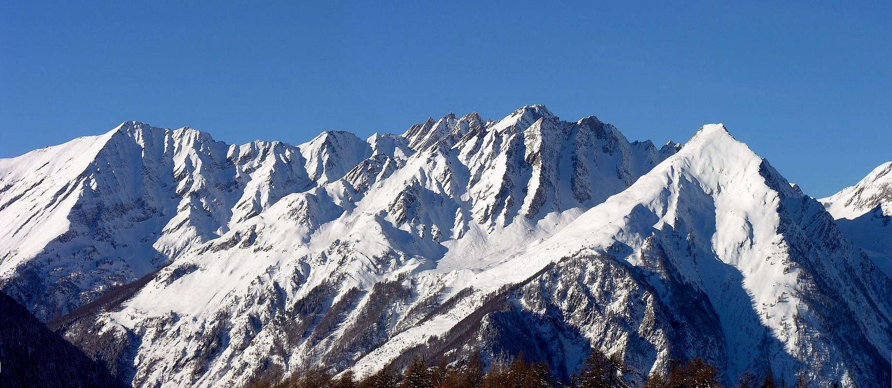
Mountain Condition
- You can get meteo information at the official site of the Regione Valle d'Aosta:
Valle d'Aosta Meteo
- Meteo: You can find more weather information on the website 3B Meteo:
La Thuile
Webcam
- WEBCAM on Aosta Valley:
- Webcam
Books and Maps
BOOKS:- "Guida dei Monti d'Italia–Alpi Graie Centrali" di Alessandro Giorgetta - Club Alpino Italiano/Touring Club Italiano, 1985 (in Italian).
- "Guida delle Alpi Occidentali", di Giovanni Bobba e Luigi Vaccarone C.A.I. Sezione di Torino Volume II (parte II), 25 Maggio 1896.
- "Valdigne gli itinerari escursionistici", di Alessandro Giorgetta, Ed. Zanichelli, Giugno 1981.
- "Guida della Regione Autonoma Valle d'Aosta" di Mario Aldrovandi, Ed. S.P.E. di Carlo Fanton, Torino 1964.
 |
 |
 |
MAPS:
- Kompass "Gran Paradiso Valle d'Aosta Sentieri e Rifugi" Carta turistica 1:50.000.
- L'Escursionista "Monte Bianco Courmayeur Carta dei Sentieri" (n° 1) 1:25.000.
- L'Escursionista "La Thuile-Piccolo San Bernardo" (carta n° 2) 1:25.000.
- A.I.A.T. La Thuile, "La Thuile Pianta dei Sentieri", 2004 (Plastico).
- Carta Comunità Montana "Valdigne e Mont Blanc Les Sentiers", 2001 1:50.000.
- I.G.C. Istituto Geografico Centrale Torino "Monte Bianco-Courmayeur-Chamonix-La Thuile" (carta n° 107), 1:25.000.
Important Information
- REGIONE AUTONOMA VALLE D'AOSTA the official site.
- FONDAZIONE MONTAGNA SICURA Villa Cameron, località Villard de la Palud n° 1 Courmayeur (AO) Tel: 39 0165 897602 - Fax: 39 0165 897647.
- Società Guide Alpine Courmayeur www.Guidecourmayeur.com - Strada Villair n° 2 - 11013 Courmayeur (Aosta) Italy - Tel. +390165842064 Fax. +390165842357 - P.I. 01022640070
- COMPAGNIE DES GUIDES RUTOR Fraz. Entrèves tel/fax 0039.0165.885574 e-mail Guidealpine@lathuile.it
- A.I.NE.VA. (Associazione Interregionale Neve e Valanghe).
Useful numbers
- Protezione Civile Valdostana località Aeroporto n° 7/A Saint Christophe (Ao) Tel. 0165-238222.
- Bollettino Meteo (weather info) Tel. 0165-44113.
- Unità Operativa di Soccorso Sanitario Tel. 118.
Acknowledgements
I am greatly indebted to my friend "Osva" for all texts and the translation of the text from italian.