
-
 6001 Hits
-
 79.78% Score
-
 11 Votes
|
|
Mountain/Rock |
|---|---|
|
|
45.67764°N / 7.01949°E |
|
|
Mountaineering |
|
|
10450 ft / 3185 m |
|
|
Overview
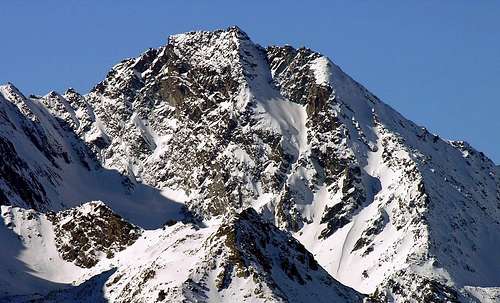
Last summit of the ridge from the Rutor Pass watershed that reaches northward to Château Blanc, Doravidi, Flambeau and Planaval Pass, Paramont Group and Mount Monchette, Mount Lussè and Becca Pouignenta, near Pietra Rossa Lake. Good vantage point on nearby Mount Paramont, Testa del Rutor and Mont Blanc Mountain Chain and other major mountains of Aosta Valley.
Ultima vetta della cresta spartiacque che dal Colle del Rutor raggiunge verso nord il Château Blanc, il Doravidi, il Flambeau e il Passo di Planaval, il Gruppo del Paramont raggiungendo il Monte Monchette, il Mont Lussè e la Becca Pouignenta, vicino al Lago di Pietra Rossa. Buon punto panoramico sul vicino Monte Paramont, sulla Testa del Rutor sul Massiccio del Monte Bianco e altre importanti montagne della Valle d'Aosta.
First Ascents
- Firs on the summit: Unknown.
- First ascent in winter: Unknown.
- N-W Arête from Passo Alto: Unknown.
- S Arête from Ussellettes Pass: A. Adami, L. Savoye and C. Paradisi, (Jul 17th, 1938).
Getting There
BY CAR:- From Torino, Milano, etc: Motorway A5. Exit in Morgex.
- From Switzerland: through the Grand St. Bernard Tunnel or the homonym Pass.
- From France: through Mont Blanc Tunnel or Petit St. Bernard Pass.
BY PLANE:
- Aeroporto "Corrado Gex" Saint Christophe (Aosta).
![]()

Itinerary
From the City of Aosta (583m) take SS.26 or Turnpike A5 toward Mont Blanc: from Morgex (923m) head for the small City of La Salle, arrived at Le Pont cross the bridge over the Dora in the direction of the Village of Chabodey, and proceed along the country road that runs through the thick forest toward Alpe Lazei (1.515m). But you must park before, not far from Chabodey, since the country road is open only to residents. Continue in the direction of Montagna della Valle (1.815m) and, on easy mule-track, reach eventually Montagna Alta (1.849m). Here the trail forks: a side spur goes on to Gran Bouillon-more precisely to Alpe Leseney (2.095m). Keep on the main trail along the floor of Vallone di Sopra (d'en Haut) until Montagna di Promou (2.018m). It's about 3 hours from La Salle to here.Dalla città di Aosta (583 m) si prende la SS.26 per il Monte Bianco oppure l'Autostrada A5 fino a Morgex (923 m) dirigersi verso i comune di La Salle (994 m) qui attraversare il ponte sulla Dora il direzione dell'abitato di Chabodey risalendo tra la fitta foresta, la strada interpoderale verso l'alpe Lazei (1.515 m); proseguire quindi in direzione della montagna della Valle (1.815 m) e, sempre su comoda mulattiera, toccare la successiva montagna Alta (1.849 m). Da questo punto il sentiero si biforca inviando un ramo secondario in direzione del Gran Bouillon e precisamente verso l'alpe Leseney (2.095 m); proseguire invece sul fondo del vallone di Sopra sino alla montagna di Promou (2.018 m) ore 3h'00 da La Salle.
Route
From the pasture continue briefly along the trail, which, after a right turn, ends on the moraine at the foot of the eastern slopes of Chanté Colmet. Leave the trail to stay on the valley floor aiming for a small lake (2.123m). From this point back to the Southwest and reach the Alto (High) Pass (2.860m). From the Pass get on the ridge and past a small saddle and a "plate" (II°-), not difficulty (but exposed), you soon reach the summit (2h'00/2h'30).Dall'alpeggio proseguire per breve tratto lungo il sentiero che, svoltando a destra, va a morire sulla morena alle pendici orientali della Chanté Colmet per abbandonarlo presto continuando sul fondovalle in direzione di un piccolo laghetto (2.123 m). Da questo punto risalire verso Sud-ovest e raggiungere il Colle del Passo Alto (2.860 m). Dal Colle continuare a salire sul filo di cresta e, superata una piccola sella e una placca (II°-), non difficile (ma esposto), si raggiunge in breve la vetta (2h'00/2h'30).
Difficulty
The routes can be rated as EE/F+/D-.Da escursionismo.
 |
 |
 |
 |
 |
Mountain Conditions
- Meteo: you can find all the needed informations at the official site of the Valle d'Aosta Region:
- Valle d'Aosta Meteo
Webcam
- WEBCAM on Aosta Valley:
- Webcam
Campings
Remember that free camping is forbidden (except for emergency reasons, over 2.500m, from darkness until dawn).Books and Maps
BOOKS:- "Guida delle Alpi Occidentali" di Giovanni Bobba e Luigi Vaccarone C.A.I. Sezione di Torino Volume II (parte II) 25-05-1896.
- "Guida dei Monti d'Italia Alpi Graie Centrali" di Alessandro Giorgetta - Club Alpino Italiano-Touring Club Italiano, 1985 (in Italian).
 |
 |
MAPS:
- Kompass "Massiccio del Monte Bianco Valle d'Aosta" sentieri e Rifugi Carta turistica 1:50.000.
- Kompass "Gran Paradiso Valle d'Aosta" sentieri e Rifugi Carta turistica 1:50.000.
- L'Escursionista "La Thuile-Piccolo San Bernardo" Carta dei sentieri (n° 2) 1:25.000.
- Enrico Editore Ivrea-Aosta "Gruppo del Gran Paradiso" 1:50.000.
- I.G.M. Istituto Geografico Militare Maps 1:25.000.
Important Information
- REGIONE AUTONOMA VALLE D'AOSTA the official site.
- FONDAZIONE MONTAGNA SICURA Villa Cameron, località Villard de la Palud n° 1 Courmayeur (AO) Tel: 39 0165 897602 - Fax: 39 0165 897647.
- COMPAGNIE DES GUIDES RUTOR Fraz. Entrèves tel/fax 0039.0165.885574 e-mail Guidealpine@lathuile.it
- A.I.NE.VA. (Associazione Interregionale Neve e Valanghe).
Useful Numbers
- Protezione Civile Valdostana località Aeroporto n° 7/A Saint Christophe (Ao) Tel. 0165-238222.
- Bollettino Valanghe Tel. 0165-776300.
- Bollettino Meteo Tel. 0165-44113.
- Unità Operativa di Soccorso Sanitario Tel. 118.