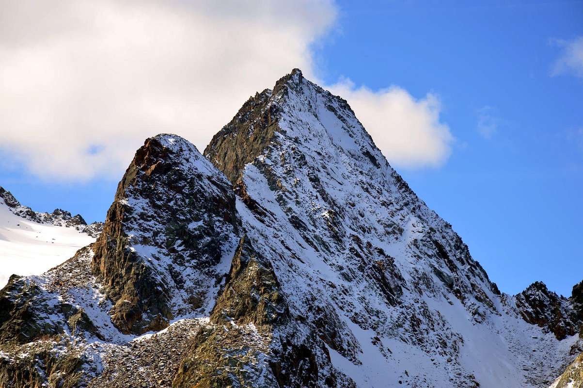
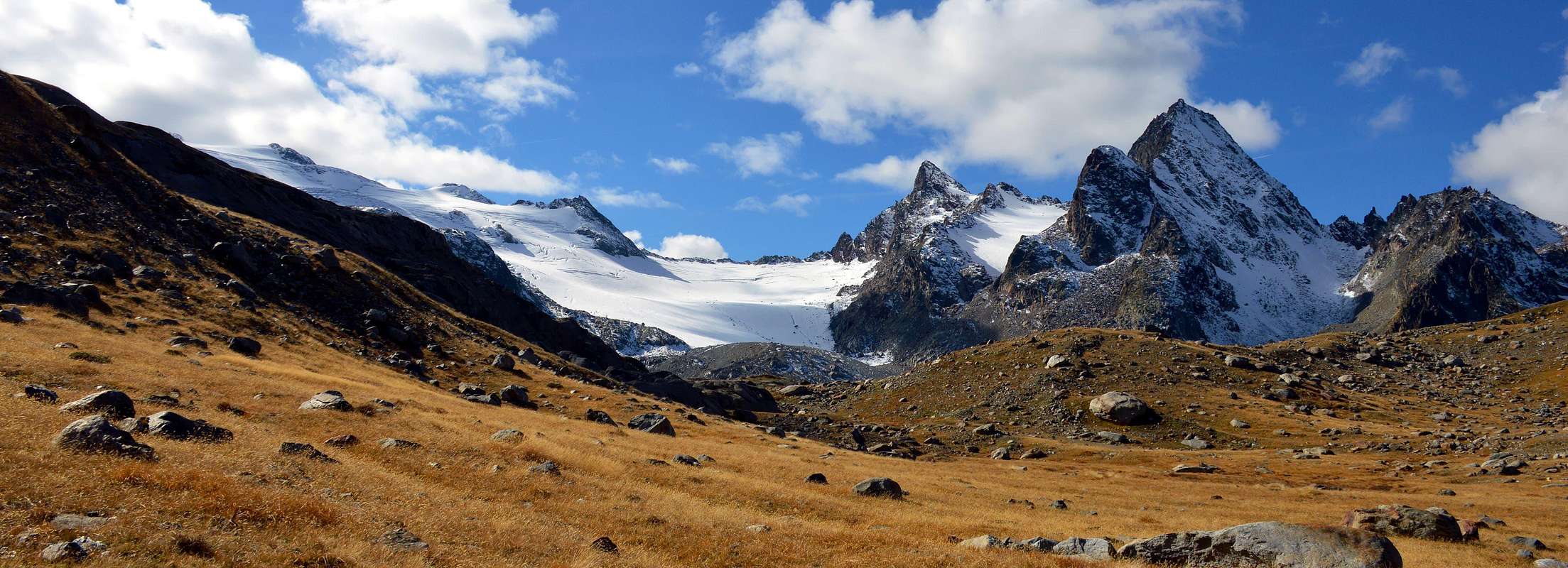
Dark and severe peak on the left of the Rutor Glacier with a superb panorama on Rutor and Mont Blanc. The route is very various from the simple trekking to the glacier and easy rock climbing in the terminal part. The severe aspect, some problem to face to cross the Rutor torrent and the absence of path over the hut (Rifugio Albert Deffeyes) reduce the number of the climbers. The easier normal route requests one step of about 20 meters of 2nd degree.
Picco scuro e severo sulla sinistra del Ghiacciaio Rutor con un superbo panorama su Rutor e il Monte Bianco. Il percorso è molto diverso con la semplice escursione per il ghiacciaio e facile arrampicata nella parte terminale. L'aspetto grave, qualche problema da affrontare per attraversare il torrente Rutor e l'assenza di percorso da oltre il rifugio (Rifugio Albert Deffeyes) riducono il numero degli scalatori. La Via Normale più semplice richiede un passo di circa 20 metri di 2° grado.
First ascents
First Climber: Jacquemod from italian, Col Tachuy, side (Sep 1878).
First climbers of north face: Puiseux brothers, (1879).
First Climbers of the normal route here reported: M. Velasco, I. Belfrond, V. Belfrond. (1890).
First of the Northwestern Face: Osvaldo Cardellina, lone; Aug 18th, 1988.
First winter climbers of the north face: D. Arnod, D. Carlin, P. Creus, R. Willien of the Italian Alps Toops, (1940).
Getting There
BY CAR:
From the Morgex exit of Motorway A5 (921m), continue for about 3 km on SS.26 towards Pré Saint Didier (1.017m). SS.26 becomes the main street of the small city and then continues toward Colle del Piccolo San Bernardo (2.188m). After several hairpins, and past the Villages of Elevaz (1.302m) and La Balme (1.309m) reach the famous ski resort of La Thuile (1.441m). Turn left on the bridge that crosses Dora di La Thuile in the direction of the Village of La Joux. After about 2 km from the bridge, having past a large square, cross another bridge on the Dora to the right. (From this point on, the road, although paved, is quite narrow. Proceed with caution.) After 1 km get to La Joux (1.607m) and park in one of the two parking lots, which are large but sometimes fill up in August. For this reason, access past the second bridge is limited at certain times. Be there before 9 AM to avoid problems, or take the shuttle bus to cover the last stretch.
IN AUTO:
Dall'uscita dell'Autostrada A5 nel Comune di Morgex (921 m) proseguire per circa 3 km lungo la SS.26 verso il Paese di Pré Saint Didier (1.017 m); addentrarsi nella via centrale del paese e proseguire sempre lungo la SS.26 che porta al Colle del Piccolo San Bernardo (2.188 m). Dopo numerosi tornanti e, superate le Frazioni di Elevaz (1.302 m) e La Balme (1.309 m), si giunge alla famosa località sciistica di La Thuile (1.441 m); svoltare a destra sul ponte che attraversa la Dora di La Thuile e dirigersi verso la Frazione di La Joux (1.607 m). Dopo circa 2 km e superato un ampio piazzale, riattraversare sempre sulla destra un altro ponte sulla Dora (attenzione da questo punto la strada, seppur asfaltata, è molto stretta, procedere con cautela) e dopo circa 1 km. si giunge a La Joux (1.607 m); qui posteggiare l'auto in uno dei due ampi parcheggi a volte insufficienti nel mese di agosto. Per questo motivo, relativamente al tratto dopo il secondo ponte, c'è una limitazione oraria all'accesso dei mezzi privati, che comunque non tocca chi arriva prima delle 9. In alternativa esiste comunque una navetta bus.
BY PLANE:
Aeroporto "Corrado Gex" Saint Christophe (Aosta).
Route
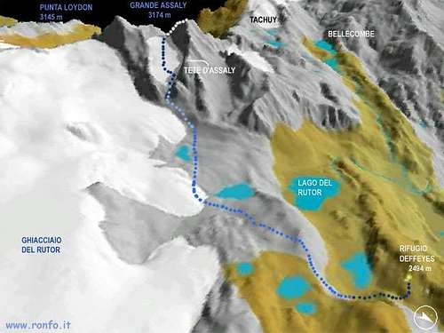
From La Joux (1.607m) walk along the path that borders to the E the stream of Rutor and its 3 fine waterfall. Once at the fork (2.100m) turn to the right along the path leading to the Valley of Bella Combe; after a few abandon it and go toward SE to reach the lake named Lac des Seracs (2.387m). Walk along the stream, along tiring moraines, to get the Lacs Neuves (2.551m) Turning to Southwest ascend for one hundred meters up to the Glacier Oriental du Grand Assaly, between the Tête d'Assaly and the Northeast Spur of the Punta Loydon. Climb Southwest the bottleneck leading to the upper small basin and, in a few, to the Colle d'Assaly (3.002m), between the Grande Assaly (3.172m) and the Punta Loydon; follow the South-outhwestern Ridge staying a little low on its Western side (I°/I°+, with one short step of II°-). Along slabs and rocks up to the Summit; staying on the edge of the ridge you could climb the various spikes alternate with small rocky walls requiring a not dificult climb (I°+/II°/II°+; 4h'30/5h'00).
Descent: coming back is along the same route.
Dalla Frazione di La Joux (1.607 m) risalire il sentiero che a E fiancheggia il Torrente du Rutor e le sue tre belle cascate. Raggiunto il bivio a quota 2.100 metri, svoltare verso destra sul sentiero che conduce al Vallone di Bella Combe, abbandonandolo presto e, con direzione Sudest raggiungere il Lac des Seracs (2.387 m). Seguire l'immissario, con percorso faticoso su morene, proveniente dai Lacs Neuves (2.551 m), e raggiungerli; volgendo a Sudovest, risalire per un centinaio di metri fino alla fronte del Glacier Oriental du Grand Assaly, tra la Tête d'Assaly e lo Sperone Nordest della Punta Loydon. Affrontare verso Sudovest la strettoia che conduce al superiore piccolo bacino e da questo in breve al Colle d'Assaly (3.002 m), a cavallo tra la Grande Assaly (3.172 m) e la Punta Loydon; seguire la Cresta Sud-sudovest tenendosi leggermente sotto ad Occidente (I°/I°+ con uno di II°-). Per rocce rotte e placche si raggiunge la vetta; volendo percorrere la cresta sul filo su diversi spuntoni alternati a muretti rocciosi (I°+/II°/II°+; 4h'30/5h'00).
Discesa: per la stessa via di salita.
Difficulty
From F to F+ with a step of II°-.
Da F a F+ con un passaggio di II°-.
Equipment
Mountaineering equipment including helmet, rope, ice axe, and crampons.
Da alta montagna, casco, corda, piccozza e ramponi.
Campings
Remember that free camping is forbidden (except for emergency reasons, over 2.500m, from darkness until dawn).
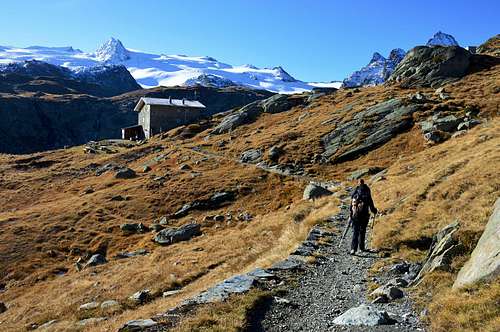
The mountain is usually climbed from half july to half september. Out of this season the climb requests to be good alpinist with experience of the place and a good winter equipment. In the Rifugio Deffeyes there is a winter room always open but no guardian and foods are in place. In winter there is danger of avalanches.
Mountain Conditions
You can get meteo information at the official site of the Regione Valle d'Aosta:
Children refers to the set of objects that logically fall under a given object. For example, the
Aconcagua mountain page is a child of the 'Aconcagua Group' and the 'Seven Summits.' The
Aconcagua mountain itself has many routes, photos, and trip reports as children.
Parents refers to a larger category under which an object falls. For example, theAconcagua mountain page has the 'Aconcagua Group' and the 'Seven Summits' asparents and is a parent itself to many routes, photos, and Trip Reports.

 10203 Hits
 93.35% Score
 42 Votes