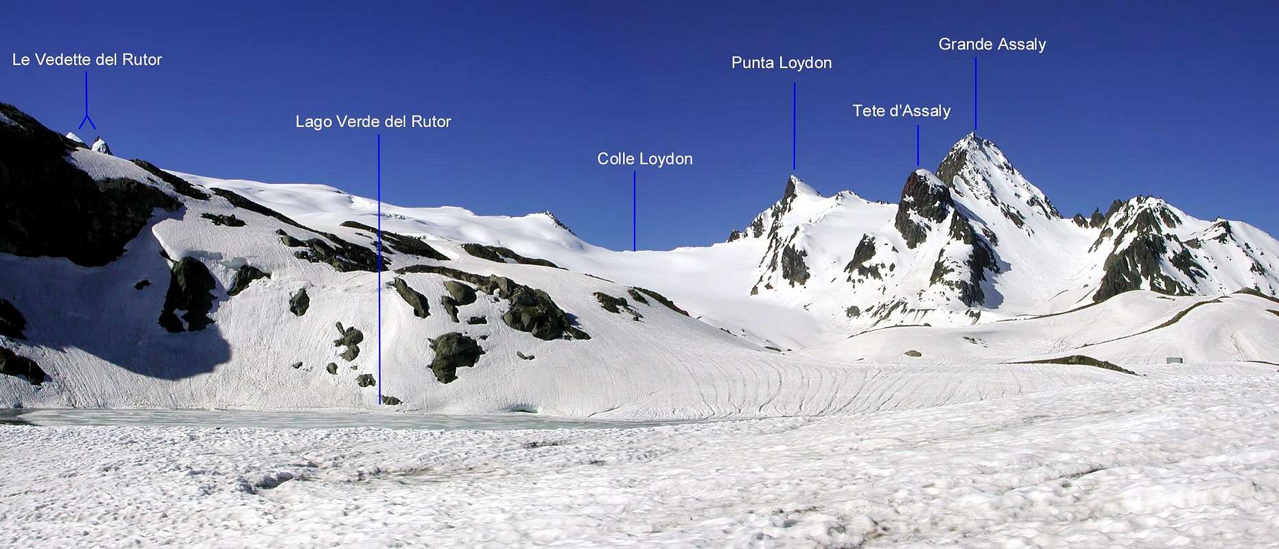
Small and smart pyramide, placed between the Assaly and Loydon Passes, and surrounded by the big Rutor Glacier on the SE side and the small Assaly Glaciers to the E. This summit looks overhwelmed by the close Grand Assaly, due not to its height but to its much bigger structure. Toward W, the ridge named Arête d'Assaly goes down into the National Park of the Vanoise.
Piccola ed elegante piramide, situata tra i Colli d'Assaly e di Loydon; circondata a SE dal grande Ghiacciaio del Rutor e ad E dai piccoli Ghiacciai d'Assaly e d'Assaly Orientale. Rimane "soffocata" dalla vicina Grande Assaly, non tanto per la maggior altezza, quanto per la maggiore massa. Lascia cadere a W l'Arête d'Assaly sul Parco Nazionale della Vanoise.
First Ascents
Firs on the summit (SE Arête): G. Bobba, L. Cibrario L. Vaccarone and G. Noro, (Aug 19 th, 1890).
First ascent in winter: Unknown.
W Arête: E. Andreis, L. Bond and E. Denina, (Aug 04th, 1927).
N Wall: E. Canzio, G. Balestrero, P. Balestrero, T. Manaira, N. Vigna and Boggiatto, (Aug 10th, 1891).
N-E Eperon: Osvaldo Cardellina, (Aug 10th, 1996).
E Wall: Giuseppe Alliod and Vito Favre, (1969).
Getting There
BY CAR:
From the Morgex exit of Motorway A5 (921m), continue for about 3 km on SS.26 towards Pré Saint Didier (1.017m). SS.26 becomes the main street of the small city and then continues toward Colle del Piccolo San Bernardo (2.188m). After several hairpins, and past the Villages of Elevaz (1.302m) and La Balme (1.309m) reach the famous ski resort of La Thuile (1.441m). Turn left on the bridge that crosses Dora di La Thuile in the direction of the Village of La Joux. After about 2 km from the bridge, having past a large square, cross another bridge on the Dora to the right. (From this point on, the road, although paved, is quite narrow. Proceed with caution.) After 1 km get to La Joux (1.607m) and park in one of the two parking lots, which are large but sometimes fill up in August. For this reason, access past the second bridge is limited at certain times. Be there before 9 AM to avoid problems, or take the shuttle bus to cover the last stretch.
IN AUTO:
Dall'uscita dell'Autostrada A5 nel Comune di Morgex (921 m) proseguire per circa 3 km lungo la SS.26 verso il Paese di Pré Saint Didier (1.017 m); addentrarsi nella via centrale del paese e proseguire sempre lungo la SS.26 che porta al Colle del Piccolo San Bernardo (2.188 m). Dopo numerosi tornanti e, superate le Frazioni di Elevaz (1.302 m) e La Balme (1.309 m), si giunge alla famosa località sciistica di La Thuile (1.441 m); svoltare a destra sul ponte che attraversa la Dora di La Thuile e dirigersi verso la Frazione di La Joux (1.607 m). Dopo circa 2 km e superato un ampio piazzale, riattraversare sempre sulla destra un altro ponte sulla Dora (attenzione da questo punto la strada, seppur asfaltata, è molto stretta, procedere con cautela) e dopo circa 1 km. si giunge a La Joux (1.607 m); qui posteggiare l'auto in uno dei due ampi parcheggi a volte insufficienti nel mese di agosto. Per questo motivo, relativamente al tratto dopo il secondo ponte, c'è una limitazione oraria all'accesso dei mezzi privati, che comunque non tocca chi arriva prima delle 9. In alternativa esiste comunque una navetta bus.
BY PLANE:
Aeroporto "Corrado Gex" Saint Christophe (Aosta).
Route
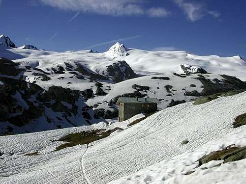
From La Joux (1.607m) walk along the path that borders to the E the stream of Rutor and its 3 fine waterfall. Once at the fork (2.100m) turn to the right along the path leading to the Valley of Bella Combe; after a few abandon it and go toward SE to reach the lake named Lac des Seracs (2.387m). Walk along the stream, along tiring moraines, to get the Lacs Neuves (2.551m) Turning to SW ascend for one hundred meters up to the Glacier Oriental du Grand Assaly, between the Tête d'Assaly and the NE spur of the Punta Loydon. Climb SW the bottleneck leading to the upper small basin and, in a few, to the Colle d'Assaly (3.002m), between the Grande Assaly (3.172m) and the Punta Loydon; follow the NNW ridge staying a little low on its E side. Along slabs and rocks up to the summit; staying on the edge of the ridge you could climb the 3 spikes requiring a not dificult climb (II°+) (4h'00/5h'00). Coming back is along the same route.
Dalla Frazione di La Joux (1.607 m) risalire il sentiero che a E fiancheggia il Torrente du Rutor e le sue tre belle cascate. Raggiunto il bivio a quota 2.100 metri, svoltare verso destra sul sentiero che conduce al Vallone di Bella Combe, abbandonandolo presto e, con direzione SE raggiungere il Lac des Seracs (2.387 m). Seguire l'immissario, con percorso faticoso su morene, proveniente dai Lacs Neuves (2.551 m), e raggiungerli; volgendo a SW, risalire per un centinaio di metri fino alla fronte del Glacier Oriental du Grand Assaly, tra la Tête d'Assaly e lo sperone NE della Punta Loydon. Affrontare verso SW la strettoia che conduce al superiore piccolo bacino e da questo in breve al Colle d'Assaly (3.002 m), a cavallo tra la Grande Assaly (3.172 m) e la Punta Loydon; seguire la cresta N-NW tenendosi leggermente sotto a E. Per rocce rotte e placche si raggiunge la vetta; volendo percorrere la cresta sul filo su tre spuntoni II°+ (4h'00/5h'00). Discesa per la stessa via di salita.
Difficulty
Difficulty of the route PD- (UIAA).
L'itinerario è considerato PD-.
Equipment
Mountaineering equipment including rope, ice axe, and crampons.
Parents refers to a larger category under which an object falls. For example, theAconcagua mountain page has the 'Aconcagua Group' and the 'Seven Summits' asparents and is a parent itself to many routes, photos, and Trip Reports.

 5606 Hits
 88.61% Score
 27 Votes