
-
 6575 Hits
-
 84.82% Score
-
 19 Votes
|
|
Mountain/Rock |
|---|---|
|
|
45.73100°N / 6.83002°E |
|
|
Summer |
|
|
9524 ft / 2903 m |
|
|
Overview
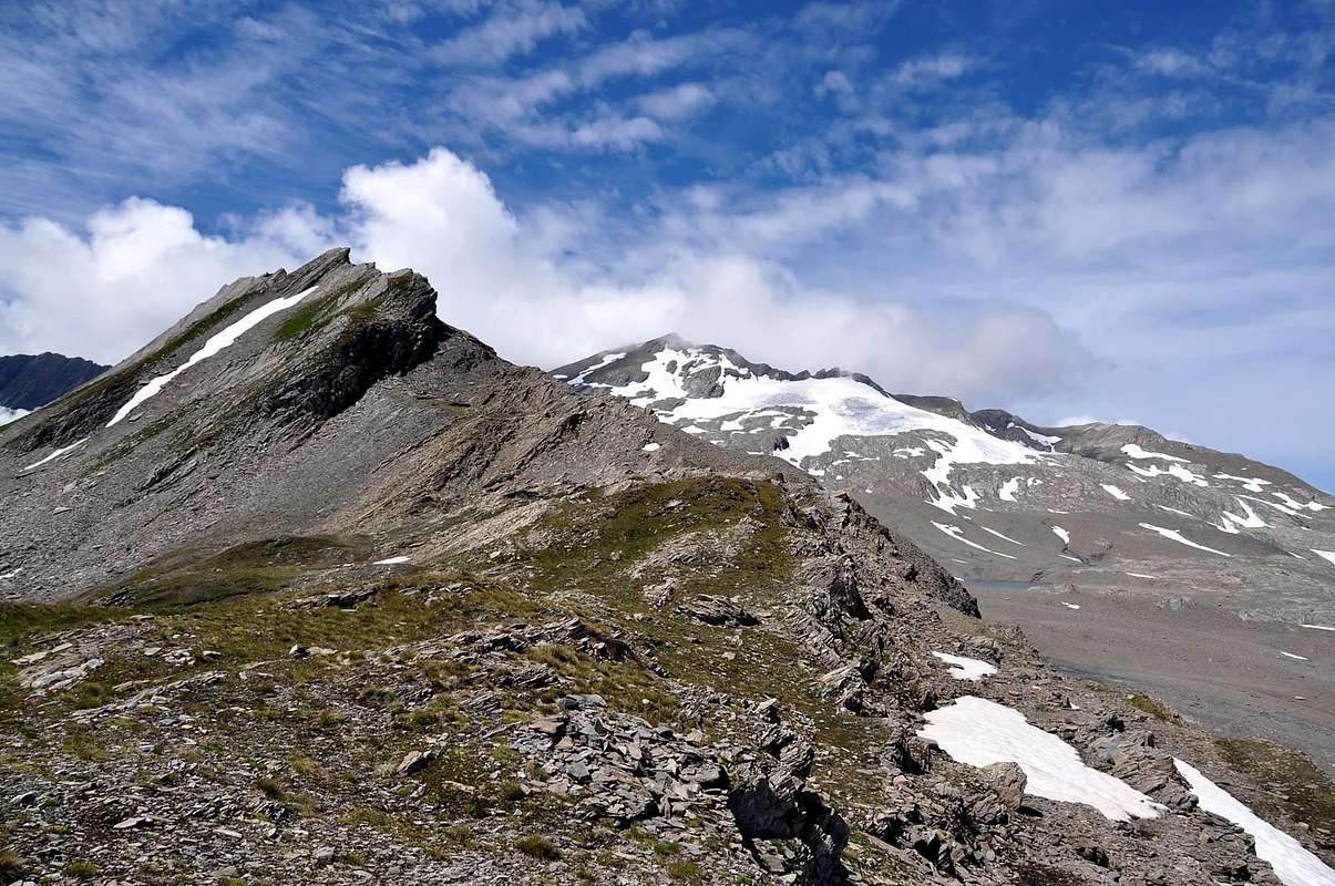
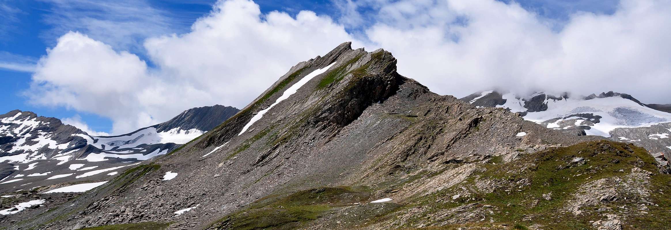
Mountain in the shape of crest, extended in East/West axe, between Breuil Valley in South and Chavannes Vallon (= great valley) in North, both belonging La Thuile Ressort/Area. Good views to nearby Aiguille des Glaciers, Aiguilles de Trélatete and whole and entire Mount Blanc Mountain Chain, to South in Rutor/Mount Paramont Group.
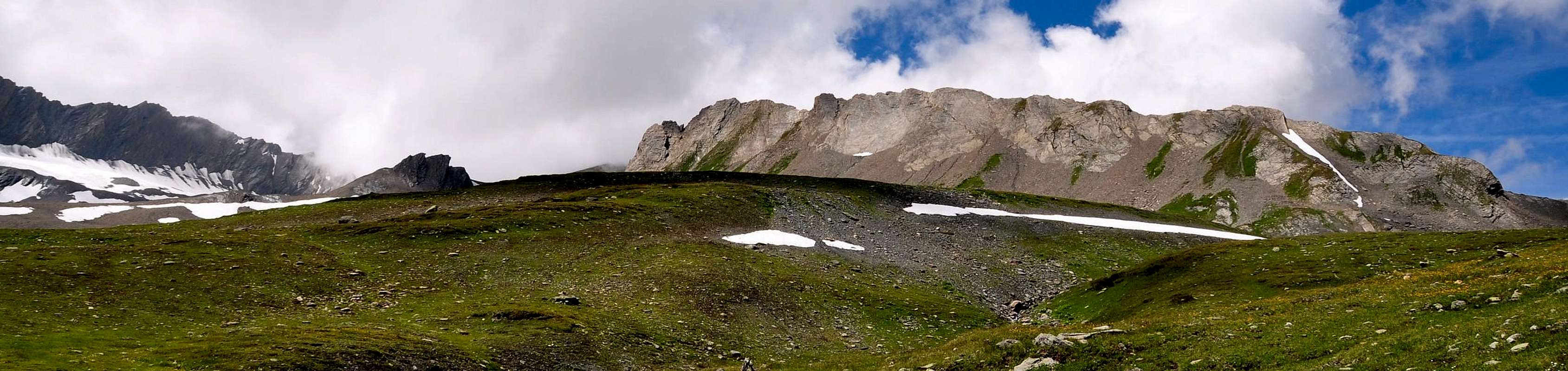
Montagna a forma di cresta allungata sull'asse Est/Ovest, tra il Vallone del Breuil a Sud e quello di Chavannes a Nord, entrambi appartenenti al comprensorio di La Thuile. Ottine viste su Aiguille de Glacier, Aiguille de Trélatete e sull'intera catena del Monte Bianco verso N; verso S sul Gruppo Rutor/Mont Paramont.
![]()
First Ascents
- First on the summit: E. Ferrari and S. M. Baratono, (Jul 13th, 1914).
- ENE Arête: E. Ferrari and S. M. Baratono, (Jul 13th, 1914).
- In winter: Unknown.
Getting There
BY CAR:- From the Morgex exit of Motorway A5 (921m), continue for about 3 km on SS.26 towards Pré Saint Didier (1.017m). SS.26 becomes the main street of the small city and then continues toward Colle del Piccolo San Bernardo (2.188m). After several hairpins, and past the Villages of Elevaz (1.302m) and la Balme (1.309m) reach the famous ski resort of La Thuile (1.441m). Turn left on the bridge that crosses "Dora di La Thuile", a go on along the same road continue to rise along the National Road n° 26, which leads to the Piccolo San Bernardo Pass to Lake Verney (2.088m) just below the pass.
- Dall'uscita dell'Autostrada A5 nel comune di Morgex (921 m) proseguire per circa 3 km lungo la SS.26 verso il Paese di Pré Saint Didier (1.017 m), addentrarsi nella via centrale del paese e proseguire sempre lungo la SS.26 che porta al Colle del Piccolo San Bernardo (2.188 m). Dopo numerosi tornanti e superate le Frazioni di Elevaz (1.302 m) e la Balme (1.309 m) si giunge alla famosa località sciistica di La Thuile (1.441 m). Svoltare a destra sul ponte che attraversa la "Dora di La Thuile", continuare a salire lungo la SS.26 che conduce al Colle de Piccolo San Bernardo fino al Lago di Verney (2.088 m) sito appena sotto il colle.
- Aeroporto "Corrado Gex" Saint Christophe (Aosta).
Approachs
From parking (2.098m), near the Verney Lake (2.088m), by Northwest direction and groundroad to descend briefly to of same effluent (Lake Torrent) in quota (2.079m); in fork of same (continued in Northeast toward nearby Lechepré Pasture, (2.017m) with other three paths, to choose the first in left and, by before SW direction, after North to reach the Higher Verney Lake (2.280m). Tourning in right (East) and passing between the same and a tiny lake to arrive at a cross with principal path, in the junction of two small torrents. Continue in Northnortheast to Torvéraz Alp (variant), also, always by the same and NW direction, to small basin, with little lake, sited below S Slopes of small, but smart, Red Point (2.659m); to go up higher "colletto" (= small and round pass), straight away in West of same (2.551m). To like this "penetrate" into Tormotta(z)s Vallon (=great alpine valley), forwarded the Breuil, true and own; leaving in left (West) two of Red Point minilakes to reach the effluent in quota 2.490m~, to be transformed the same, immediately afterwards, the tributary of more important following Tormotta two Lakes (2.486m the major), below of typical "great bread" Tormotta Point (2.686m). To wade across, non always easily (above all in evening return for considerable of waters a rise) getting in gravely tableland, amongst various lakes; by North direction and scarce traces to join with Arguerey Torrent, encircled by numerous and with the same name small lakes, in quota (2.436m), junction point by from West the Hermite Torrent and two Northern and Southern Arguerey Torrent; from Northwest the Breuil Torrent. Cross by same direction, turning briefly in Northwest and doubling in right (Northeast) on Glaciers Point NE Slope, and, between Verney Torrent in left and Verney Doire (= small stream-torrent), reach two other little lakes, in quota (2.528m).Dal parcheggio (2.098 m), presso il Lago di Verney (2.088 m), con direzione NW e strada poderale scendere brevemente verso l'emissario dello stesso (Torrent du Lac) a quota (2.079 m); all'incrocio della stessa (che continua a NE verso la vicina Alpe Lechepré; 2.017 m) con altri tre sentieri, prendere il primo di sinistra e, con direzione prima SW e poi N, raggiungere il Lac de Verney Dessous (2.280 m). Aggirandolo sulla destra (E) e transitando in mezzo tra lo stesso ed un minuscolo laghetto, pervenire all'incrocio con il sentiero principale, vicino alla congiunzione di due torrentelli. Continuare verso N-NE verso l'Alpe di Torvéraz (variante), oppure sempre con lo stesso, e con direzione NW, verso il piccolo bacino con laghetto posto alle pendici S della piccola, ma elegante, Pointe Rouge (2.659 m); risalire al soprastante colletto, subito ad W della stessa (2.551 m). Entrare così nel Vallone della Tormotta(z), anticipatorio a quello vero e proprio del Breuil; lasciando a sinistra (W) i due minilaghetti de la Pointe Rousse, raggiungerne l'emissario a quota 2.490 m circa, divenendo lo stesso, subito dopo, immissario dei ben più importanti Laghi della Tormotta (2.486 m) Guadare non sempre facilmente (soprattutto al ritorno serale per il notevole aumento delle acque), entrando così nel ghiaioso altipiano tra i laghi; con direzione N e scarse tracce raggiungere il Torrente di Arguerey, circondato dai numerosi ed omonimi laghetti, a quota 2.436 m, nel punto in cui si riuniscono da W il Torrente del Ghiacciaio dell'Hermite, i due Torrenti S e N di Arguerey con il Torrente del Breuil, proveniente da NW. Proseguire con la stessa direzione, piegando leggermente a NW e doppiando sulla destra (NE) il Versante NE della Punta dei Ghiacciai, tra il Torrente di Verney a sinistra e la Doire di Verney, raggiungendo due laghetti presso la quota (2.528 m).


1) - From two small lakes (2.528m), by West direction, double NE Slope of Glaciers Point (3.023m) and go up on moraine between Northern Arguerey Glacier, in South, and Breuil Glacier, in North, reaching like this just at junction of two, below Breuil Pass (2.882m). Continue, changing direction in North, and to cross, through remains, in quota 2.875/2.900m~ crossing only up a forked small lake, between Little Léchaud (2.973m) and of Bassa Serra more higher Quota (2.903m). From large saddle also Western Bassa Serra Pass (2.900m~), between Léchaud Point quota (3.102m 3.128m) and Bassa Serra Western Point (2.903m), easily reach this last, by debris, rubbles and snowfields nevati (3h'00/3h'30). Before, by Southeast direction, to cross the Quota (2.875m), after, in East, reach the following little saddle (2.850m), preceding the Quota (2.900m) or Central Summit; from this, by rocky traverse, to, by n° 4 route, Eastern Bassa Serra Pass or Col des Echelles des Chavannes (2.737m; defences) (F; EE; 3h'30/4h'30).
2) - Also, from little lakes (2.528m), by Northwest direction, crossing various of Breuil Torrent ramifications, to get in with same name valley; along the torrent, as far as the of sources rise, through moraine with scarce traces and snowfields, reach the of Western Bassa Serra more large Saddle, near the Western Summit and, by previous route, briefly in Summit (F-; E; 3h'15/3h'30).
3) - To draw near Verney Dora (= Stream) and, following of torrent course, continue up to mini lake (2.527m) and to cross through various ramification in quota (2.600m~); from this point turn in Northwest and, following of torrent the Wetern ramification and leaving in right the mini lake (2.645m~), reach an other major in quota (2.762m), including on small stony basin, between the SE little Spur of Bassa Serra Point and Central Point or Quota (2.900m); From little lake go up briefly by rubbles, debris, rotten rocks and rare snowfield to summital crest in quota (2.850m~); before by West direction, after Northwest, crossing the Quota (2.875m), by non difficult rocks, but petitioning search of passages ability, to reach the Summit (2.900m). For traverse in opposite to other two summits, see under n° 4 route (F+; 3h'30/4h'00).
4) - From little saddle (2.850m~), by Eastnortheast direction, reach, with the crossing also the of small towers, pinnacles and little walls avoidance, the Central Point (2.900m) and from this, by same of route typology (I°+/II°+, liked even III°, amusing), the Eastern Point (2.836m); before by path, after marked trace, go down to Eastern Bassa Serra Pass or Col des Echelles des Chavannes (2.737m) (F+/PD+; 4h'30/5h'00).
5) - From little lake (2.527m), by level route in quota (2.600m) with grassy/morenic slope and crossing a small torrent, with meander in the shape of long and narrow lake, possibility in existence of, by Eastern Bassa Serra Pass or Col des Echelles des Chavannes traverse in Northeast, easily to reach, through moraine with sparce traces, the path n° 10 toward Eastern Bassa Serra Pass or Col des Echelles des Chavannes. From pass, by whole crossing(F+/PD+; 4h'30/5h'00). Of the entire crest in opposite and n° 4, 3 routes reach Western Bassa Serra Pass (2.900m~) (F+/PD+; 4h'30/5h'00).
Da questo punto esistono cinque possibilità:
1) - Dai laghetti, con direzione W, doppiare il Versante NE della Punta dei Ghiacciai (3.023 m) e risalire la morena tra il Ghiacciaio Settentrionale di Arguerey, a S, e quello del Breuil, a N, portandosi così proprio alla congiunzione dei due, sotto il Colle del Breuil (2.882 m). Proseguire, cambiando direzione in N, e percorrerlo, per quel che ne resta, a quota 2.875/2.900 m~, passando appena sopra ad un laghetto biforcuto tra il Petit Léchaud (2.973 m) e la Quota più elevata della Bassa Serra (2.903 m). Dalla larga sella o Colle occidentale di Bassa Serra (2.900 m~), tra la quota (3.012 m~) della Punta Léchaud (3.128 m) e la Punta Occidentale di Bassa Serra (2.903 m), raggiungere quest'ultima in breve e facilmente su detriti, blocchi frantumati e nevati (3h'00/3h'30). Prima con direzione SE scavalcare la Quota (2.875 m), poi, verso E, raggiungere la successiva selletta (2.850 m), antecedente la Quota (2.900 m) o Punta Centrale; da questa proseguire verso il Colle di Bassa Serra Orientale o Col des Echelles des Chavannes (2.737 m.; antiche fortificazioni) con l'itinerario n° 4 (F; EE; 3h'30/4h'30).2) - Oppure, dai laghetti (2.528 m), con direzione NW, oltrepassando diverse ramificazioni del Torrente del Breuil, introdursi nell'omonimo vallone; seguendo il torrente sino al sommo delle sue sorgenti tramite morena con scarse tracce e nevati, raggiungere la larga sella della Bassa Serra Occidentale presso la Cima Occidentale e, con l'itinerario precedente, brevemente in vetta (F-; E; 3h'15/3h'30).
3) - Avvicinarsi alla Dora di Verney e, seguendone il corso, continuare sino al laghetto (2.527 m) e attraversare tra diverse ramificazioni sino in quota (2.600 m~); da questo punto volgere a NW e, seguendo il ramo occidentale del torrente e lasciando sulla destra il mini laghetto (2.645 m~), raggiungerne un altro più grande a quota (2.762 m), racchiuso in un minuscolo bacino pietroso, tra il piccolo Contrafforte SE della Punta di Bassa Serra e la Quota (2.900 m) o Punta Centrale. Dal laghetto risalire brevemente su detriti e sfasciumi, a volte qualche nevaio, alla cresta sommitale a quota (2.850 m) e, con direzione prima W, poi NW, scavalcando la Quota (2.875 m), su rocce non difficili ma richiedenti abilità di ricerca del passaggio, raggiungere la Cima (2.900 m); per la traversata in senso opposto alle altre due sommità, vedi l'itinerario n° 4 (F+; 3h'30/4h'00).
4) - Dalla selletta (2.850 m), con direzione E-NE raggiungere, con lo scavalcamento o l'aggiramento di diversi torrioni, pinnacoli e muretti, la Punta Centrale (2.900 m) e da questa, con la stessa tipologia di percorso (I°+/II°+, volendo anche III°, divertente), la Punta Orientale (2.836 m); dapprima per sentiero, poi su traccia marcata scendere verso il Col des Echellettes des Chavannes od Orientale di Bassa Serra (2.737 m) (F+/PD+; 4h'30/5h'00).
5) - Dal laghetto (2.527 m) con traversata in quota tramite pendio erboso-morenico e attraversando un torrentello con ansa a forma di laghetto allungato, esiste la possibilità con una traversata a NE di raggiungere facilmente per morena e tracce sparse il sentiero n° 10 per il Colle Orientale di Bassa Serra o Col des Echelles des Chavannes (2.737 m); da questo, in traversata dell'intera cresta della Bassa Serra con i precenti itinerari n° 4 e n° 3, raggiungere il Colle Occidentale della Bassa Serra (2.900 m~) (F+/PD+; 4h'30/5h'00).
Difficulty
This route can be considered E/PD+.L'itinerario è classificato E/PD+.


Da alta montagna, corda e casco.
Campings
Remember that free camping is forbidden (except for emergency reasons, over 2.500m, from darkness until dawn).Mountain Conditions
- You can get meteo information at the official site of the Regione Valle d'Aosta:
- Valle d'Aosta Meteo
- Meteo: You can find more weather information on the website
- 3B Meteo: Meteo Colle del Piccolo San Bernardo
Webcam
- WEBCAM on Aosta Valley:
- Webcam
Books and Maps
BOOKS:- "Guida dei Monti d'Italia–Alpi Graie Centrali", di Alessandro Giorgetta - Club Alpino Italiano/Touring Club Italiano, 1985 (in Italian).
- "Guida delle Alpi Occidentali", di Giovanni Bobba e Luigi Vaccarone C.A.I. Sezione di Torino Volume II (parte II), 25 Maggio 1896.
- "Valdigne gli itinerari escursionistici", di Alessandro Giorgetta, Ed. Zanichelli, Giugno 1981.
- "Diari Alpinistici" di Osvaldo Cardellina e Indice Generale accompagnato da Schedario Relazioni Ascensioni 1964-2019 (inediti).
 |
 |
 |
MAPS:
- Kompass "Gran Paradiso Valle d'Aosta Sentieri e Rifugi" Carta turistica 1:50.000.
- L'Escursionista "La Thuile-Piccolo San Bernardo" (carta n° 2) 1:25.000.
- A.I.A.T. La Thuile, "La Thuile Pianta dei Sentieri", 2004 (Plastico).
- Carta Comunità Montana "Valdigne e Mont Blanc Les Sentiers", 2001 1:50.000.
- L'Escursionista "Monte Bianco Courmayeur Carta dei Sentieri" (n° 1) 1:25.000.
- I.G.C. Istituto Geografico Centrale Torino "Monte Bianco-Courmayeur-Chamonix-La Thuile" (carta n° 107), 1:25.000.
Important Information
- REGIONE AUTONOMA VALLE D'AOSTA the official site.
- FONDAZIONE MONTAGNA SICURA Villa Cameron, località Villard de la Palud n° 1 Courmayeur (AO) Tel: 39 0165 897602 - Fax: 39 0165 897647.
- Società Guide Alpine Courmayeur www.Guidecourmayeur.com - Strada Villair n° 2 - 11013 Courmayeur (Aosta) Italy - Tel. +390165842064 Fax. +390165842357 - P.I. 01022640070
- COMPAGNIE DES GUIDES RUTOR Fraz. Entrèves tel/fax 0039.0165.885574 e-mail Guidealpine@lathuile.it
- A.I.NE.VA. (Associazione Interregionale Neve e Valanghe).
Useful numbers
- Protezione Civile Valdostana località Aeroporto n° 7/A Saint Christophe (Ao) Tel. 0165-238222.
- Bollettino Meteo (weather info) Tel. 0165-44113.
- Unità Operativa di Soccorso Sanitario Tel. 118.