
-
 8365 Hits
-
 85.36% Score
-
 20 Votes
|
|
Mountain/Rock |
|---|---|
|
|
45.59326°N / 7.50504°E |
|
|
Mountaineering |
|
|
10144 ft / 3092 m |
|
|
Overview
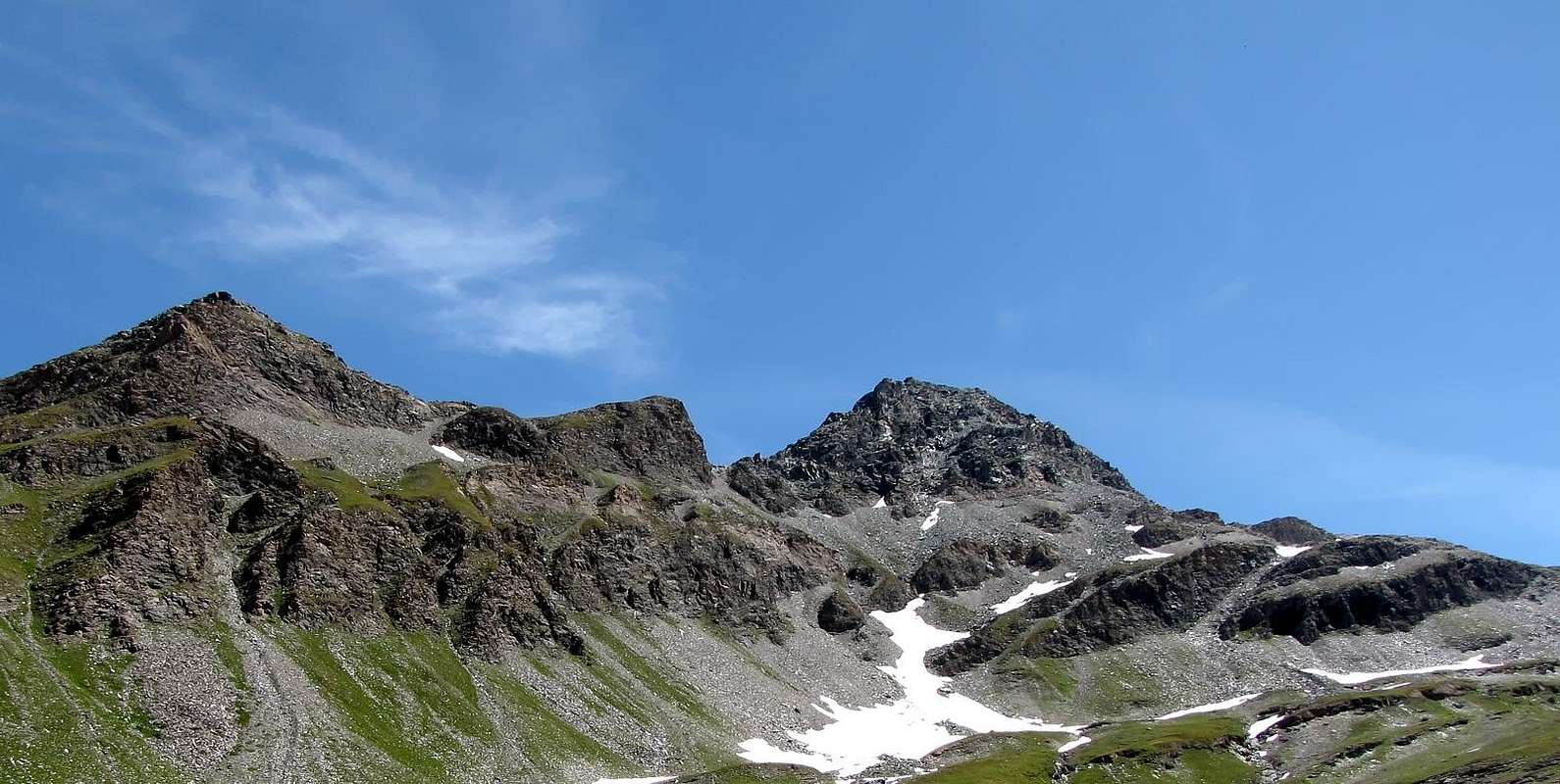
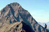
Smart triangular mountain, between the Valley of Champorcher and the Valley of Cogne, visible from the "Sogno di Berdzé refuge" on high Urtier Walloon and going from the front to the West from Dondena Village towards Lake Miserin or Fenêtre de Champorcher. Placed on the axis South/North between the saddle 2.946 meters and the Fenêtre it has four sides the last of which, addressed to Champorcher Valley, is divided into two parts by a few rock outcrops above a short vertical wall more towards Southeast. Another ridge descends to the East-northeast transforming itself at the top, on a steep pillar a hundred meters feet, very steep, so as to separate this from a second side facing North-northeast. In general, the rock is somewhat broken and often unstable, for which reason all the climbs, including those on the ridges, requiring prudence and caution, even if they are not very demanding. The routes are those along the three ridges, mainly for what comes from the Top of Péradza (3.021m), while much less popular one that goes from Fenêtre also Northwestern Ridge, since broken by a vertical wall of bluish-green rocks, of around 25/30 meters, that forces a detour left on the North side to Northeast. On the Champorcher, ie starting from Dondena also from the Miserin Shelter, uses the ridge that rises from the East-northeast of "Truc of Lake" (2.703m) until this is "dampens" against a small corner-pillar greyish. This last part is passed to the left with a diagonal ramp that starts from a very small fork or through this to the left (Southeast) and ending with the grooves rocky with soiled dirt. As for the walls is to consider that none provides a safe climbing: the Western has two-way route and rock very much exposed to falling of stones; more "interesting" to the left which ends on Ante Top Northwest not far from the Summit. The North-northeast Face, which is used for the first ascension complete in 1848, is made up of a scree slope that supports the base; the same, there is a thin trail that goes diagonally from Northwest to Southeast toward the East-North-East Crest, most likely used for the first ascension, as the castle rock Summit is quite steep and not easy to get on and it is a "loophole" by Ridge Northwest, as happened most likely in the ascent of the Abbé Gorret in 1866. The last side, that of Southeast, is yet to be explored except the part more facing East, used as a variant to climb the East-northeast Crest or Normal Route from Dondena into Valley of Champorcher. From its summit an exceptional panoramic view of the close Punta Tersiva, Rosa dei Banchi in Southeast and entire Gran Paradiso Massif.

First Ascents
- First on the Summit: Abbè Chanoux, (1848), in ascent from Cogne or Lillaz Village through N-NE Face.
- In winter: Unknown.
- S Arête (Normal Route): Unknown, in ascent from Peradzà Alp through Saddle 2.946 meters.
- W Wall: Emilio Bertona and Osvaldo Cardellina, (Oct 19th, 2003), from Sogno di Berdzé Shelter.
- W Wall (Northern Antesummit): Osvaldo Cardellina, lone (Jun 08th, 2008), in ascent from Lillaz.
- N-NW Arête (Integral): Emilio Bertona and Osvaldo Cardellina, (Jul 13th, 2000), in ascent from Peradzà Alp, Integral route from Fenêtre de Champorcher.
- NW Arête-N-NE Face traverse at base and E Crest: Abbè Aimé Gorret, (1866), in ascent most likely from Lillaz Hamlet or directly by Cogne Municipality.
- N Wall Osvaldo Cardellina and Alessandro Cardellina (Aug 20th, 2005), from Dondena, Dondena Refuge, fork 2.526 meters between Lacs Blanc and Noir, fork 2.768 meters to Finestra de Champorcher; in descent Southen Crest to mini saddle 2.983 meters, Truc del Lago, Miserin Lake and Refuge, Dondena.
- E-NE Edge: Osvaldo Cardellina, lone (Aug 19th, 2007), from Dondena with three times ascents and descents on the same day to search for Emilio Bertona.
- E-SE Wall: Osvaldo Cardellina and Nicola Colajanni (Aug 19th, 2007), from Dondena with three ascents in same day to search for Emilio Bertona.
- E Arête: M. Adrovandi and Gamekeeper Champorcher Perruchon, in ascent from Dondena (1912).
Getting There
BY CAR:- From Torino, Milano, etc: Motorway A5. Exit at Aosta Ovest. Drive to the near Aymavilles. Follow the directions for Valle di Cogne.
- From Switzerland: through the Grand Saint Bernard Tunnel or the namesake Pass. Drive to Aosta, then follow the direction for Courmayeur on SS.26. Just after Sarre, turn to the left, in the direction of Valle di Cogne.
- From France: through Mont Blanc Tunnel or Petit St. Bernard Pass. It isn't necessary to take Motorway A5: you can drive on SS.26, in the direction of Aosta.Before arriving at the Village of Sarre, turn right following the sign for Valle di Cogne. After Aymavilles, the Regional Road n°47 crosses the Villages of Vieyes, Epinel and Cretaz and after about 25 Km arrives at Cogne (1.534m). From Cogne you can get the Village of Lillaz (1.617m).
- Aeroporto "Corrado Gex" Saint Christophe (Aosta).
Approaches & Routes
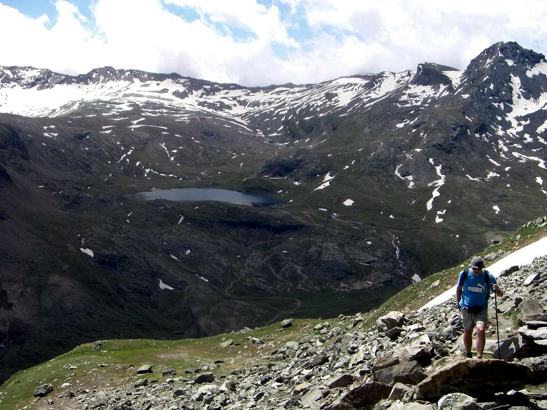
A) - From Lillaz towards Urtier Walloon and by Sogno di Berdzé Refuge: Starting from Cogne (1.534m) you must arrive (bus or car) to the car parking of Lillaz (1.617m). Follow the path n° 13/TVC/Alta Via n° 2 below upaved road, until reach Baite di Gollies Low and Upper (1.831m, 1.869m; here you can also get along the same route with slightly longer, less direct but certainly more scenic). Move on until tiny Church of Crêt (2.020m; wooden fountain), clearly visible from lowlands. Once gone beyond Tsavanis (2.296m; fountain), preceded by a magnificent waterfall upon the Torrent Urtier and above the private farms dirt road and Manda (2.370m) Pastures, the refuge is reached, immediately after a fresh spring water from a rock in a great boulder (3h'30/3h'45, from Lillaz parking). From Sogno di Berdzè (2.526m) hut, follow Southeast direction down the vallon, proceeding through a series of parallel rocky slabs alternate with ledges at the bottom and on snowfields not too steep in the upper one, heading for a most visible saddle, progressively climbing. Keep going left (North) direction, and once gone beyond some steep slopes, move toward the true base of the mountain (*** Remark: the crest, especially in the descent phase, can be walked just below with significant savings in time), through a ridge. Continue to climb on rag rocks to arrive at a big stone, then marching on wreck slopes to reach the final rocky ridge and the Summit (2h'00/2h'15, from the Hut "Sogno di Berdzé").A) - Da Lillaz attraverso il Vallone dell'Urtier appoggiandosi al Rifugio Sogno di Berdzé: Dall'abitato di Cogne (1.534 m) in bus o in auto raggiungere la ridente frazione di Lillaz (1.617 m), dove si parcheggia l'auto nel grande piazzale sito quasi al centro del villaggio. Percorrere il sentiero n° 13/TVC/Alta Via n° 2 al disotto della strada poderale e lungo la sponda Settentrionale del Torrente Urtier fino alle Baite di Gollies Dessous e Dessus (1.831 m, 1.869 m; qui si può arrivare anche percorrendo la medesima con itinerario leggermente più lungo, meno diretto, ma sicuramente maggiormente panoramico); continuare fino alla Chiesetta del Crêt (2.020 m; bella fontana scavata nel legno), ben visibile dal basso, e oltrepassati gli Alpeggi di Tsavanis (2.296 m; fontana), preceduto da una bella cascata sopra il Torrent Urtier al di sopra della poderale, ed il successivo di Manda (2.370 m) si raggiunge il Rifugio "Sogno di Berdzè" (Sogno di Pastore) presso l'Alpe di Peradzà, subito dopo un tornante seguito da un lungo rettilineo in leggera ascesa giusto appresso una fresca sorgente sgorgante da un gran masso nella roccia (3h'30/3h'45 dal parcheggio di Lillaz). Dal Rifugio Sogno di Berdzé (2.526 m), dopo aver subito attraversato il Torrent de Peradzà, seguire verso Sudest il fondo del vallone, procedendo tramite una serie parallela di banconate rocciose alternate a cenge nella parte inferiore e su nevai non troppo ripidi che gradualmente piegano sulla sinistra (Sudest) in quella superiore, in direzione di una sella (2.946 m), sempre più in vista progressivamente salendo. Continuare a sinistra (Nord) e superati alcuni dossi risalire su cresta sino alla vera base della montagna (*** Nota: la cresta, soprattutto in fase di discesa, può essere percorsa appena al di sotto con significativo risparmio di tempo; infatti le Quote varie succedentesi sono più lunghe da percorrersi che non difficili), continuare su roccia friabile fino ad un grosso masso, poi per un pendio di sfasciumi e un tratto di cresta a blocchi raggiungere la Vetta (2h'00/2h'15) dal rifugio.
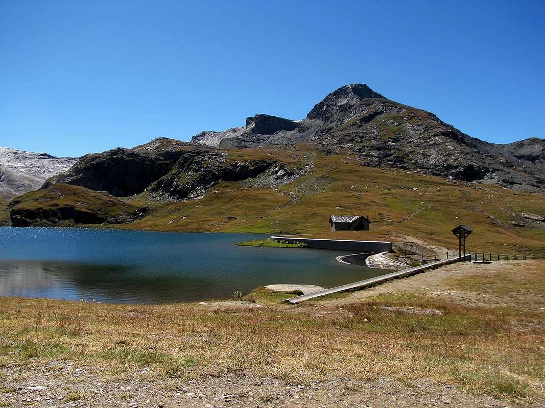
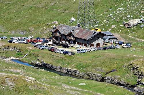
B) - From Champorcher also from Dondena Refuge to Miserin Shelter neighbor the Lake: Champorcher-Château (1.427m) go to the Village La Cort where, shortly afterwards, began the dirt "Royal Route" numbered 9/High Way n° 2; crossed to the Alps Vardette, Brenvei, Champlong Grand, Grand Pianas and Leituerie you arrive at the small parking lot just above the Village of Dondena (2.110m, panels and reports signs in yellow). After a short descent we cross the Torrent Ayasse on a small stonebridge continuing through the private farms dirt road (prohibition of passage for cars) that reaches the Dondena Refuge (2.200m). From this continue Westward with it, concomitant with the path n°7B/Alta Via n° 2, concluding with a short ascent to the South; or starting immediately behind the same, better, with the path n° 7 to reach the Miserin Shelter (2.582m; Sanctuary; 1h'00/1h'15) at the lake of the same name. This trip is already satisfactory for itself along a route that each year is crossed by a famous procession which takes place August 5th, dedicated to Madonna delle Nevi (Our Lady of the Snows) and full of a centuries-old tradition and with the participation of the inhabitants of the nearby valleys of Piedmont. It should surely the second path, the more "rapid" and less "busy" from the crowd of Walkers. From the Rifugio Miserin move towards West to a grassy-rocky promontory just to the right of the "Truc of the Lake" (2.703m); absolutely not go up directly, but using a small path unnumbered, to dub the same to the North, reaching the summit of the same (2.841m). Here the East-northeast Crest appears simple and consists of a large, grassy rounded off; the same ends, after a large rounded saddle at a edge of rocks bluish, very thin and dangerous, especially when wet to moist soil or worse. Cross it with almost flat path but exposed on both sides. After a long flight of soil and debris (around 70 meters, boring and tiring) leads to a small fork against a small and gray pillar. Do the same on the left and climb through a ramp diagonally from right to left highlighted by a block detached to about half (II°+/III°-); or descend for about 10 meters and climb through a gray slab and "lying" that leads to a rocky groove (II°-). Through this you reach the point of crossing with the previous ramp, just above. A series of fairly easy rocks, arranged in terraces but covered with soil and grass also leads after eighty feet the cairn on the Summit (EE/A/PD-; 1h'30/2h'00 from Shelter near Lake Miserin ; 2h'45/3h'15 from Refuge Dondena).
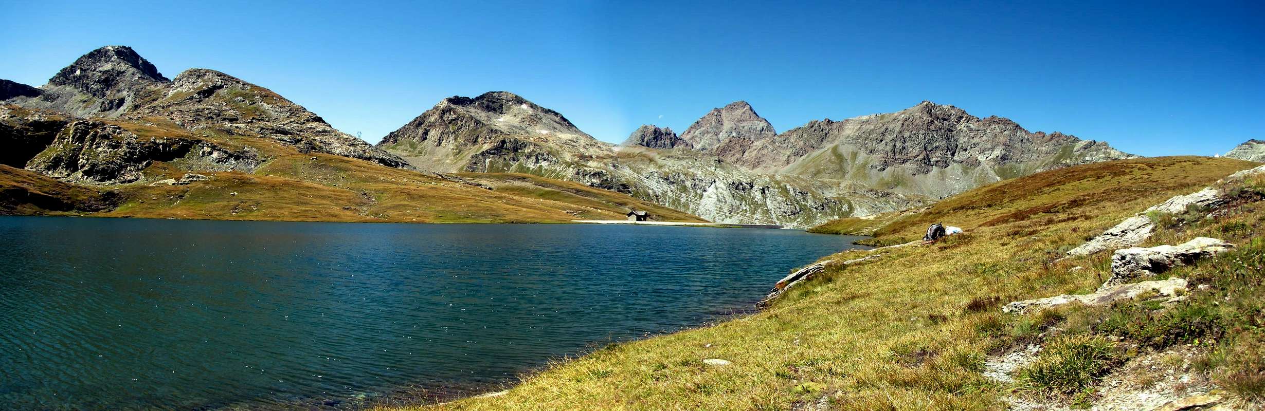
B) - Da Champorcher o dal Rifugio di Dondena appoggiandosi al Rifugio del Lago Miserin: Da Champorcher-Château (1.427 m) salire fino alla Frazione La Cort dove, poco oltre, inizia la "Strada Reale" in terra battuta numerata 9/Alta Via n° 2; superate le Alpi di Vardette, Brenvei, Grand Champlong, Grand Pianas e Leituerie si arriva al piccolo parcheggio appena sopra il Villaggio di Dondena (2.110 m; pannelli e segnalazioni segnaletiche in giallo). Dopo una corta discesa si guada il Torrent Ayasse su di un piccolo ponte proseguendo tramite la strada poderale (divieto di passaggio per le auto) che raggiunge il Rifugio Dondena (2.200 m). Da questo continuare verso Ovest con la medesima, concomitante con il sentiero 7B/Alta Via n° 2, per concludere con una piccola salita a Mezzogiorno; oppure partendo subito dietro lo stesso, e meglio, con il sentiero n° 7 raggiungendo il Rifugio del Miserin (2.582 m; Santuario; 1h'00/1h'15) presso l'omonimo Lago. Questa risulta già gita soddisfacente per se stessa lungo un itinerario che ogni anno viene percorso da una famosa Processione effettuata il 5 di Agosto e dedicata alla Madonna della Neve; la stessa é ricca d'una tradizione centenaria ed alla quale partecipano pur gli abitanti delle vicine Valli del Piemonte. Conviene di certo il secondo sentiero, più "rapido" e meno "affollato" dalla massa. Dal Rifugio Miserin indirizzarsi verso Ovest verso un promontorio roccioso-erboso subito a destra del "Truc del Lago" (2.703 m); non salire assolutamente in modo diretto ma, sfruttando un sentierino non numerato, doppiare lo stesso a Settentrione raggiungendone la Sommità (2.841 m). Qui la Cresta Est-nordest si presenta facile e formata da un grosso ed erboso tondeggiante dosso; lo stesso termina, dopo una larga sella arrotondata, presso una cresta di rocce bluastre, molto sottile e pericolosa in caso soprattutto di terreno umido od ancor peggio bagnato. Attraversarla con percorso quasi pianeggiante ma esposto su di entrambi i lati. Al termine una lunga rampa di terriccio e detriti (70 metri circa, noiosa e faticosa) conduce ad una forcelletta contro un pilastrino grigiastro. Evitare il medesimo sulla sinistra e salire tramite una rampa diagonale da destra a sinistra evidenziata da un blocco staccato a circa la metà (II°+/III°-); oppure scendere per circa 10 metri e salire tramite una placca grigia e "adagiata" che conduce ad un canalino roccioso (II°-). Tramite questo si raggiunge il punto della precedente traversata, appena al di sopra. Una serie di abbastanza facili rocce, disposte a gradoni ma ricoperte da terriccio ed anche d'erba, conduce dopo una ottantina di metri all'ometto di pietra della Cima (EE/A/PD-; 1h'30/2h'00 dal Rifugio al Lago Miserin; 2h'45/3h'15 dal Rifugio di Dondena).


L'itinerario è classificato F+/PD-.
Equipment
Standard mountaineering equipment.
Da alto escursionismo.
Huts
 |
Red Tape
Within the borders of the P.N.G.P. (Parco Nazionale del Gran Paradiso), at the moment (summer 2004), dogs generally are not allowed, except on a couple of trails, and camping is forbidden (except for climbers from sunset till dawn). No fees are due.
 |
 |
 |
 |
Campings
Remember that free camping is forbidden (except for emergency reasons, over 2.500m, from darkness until dawn).
Mountain Condition
- Meteo: you can find all the needed informations at the official site of the Valle d'Aosta Region:
- Valle d'Aosta Meteo
Webcam
- WEBCAM on Aosta Valley:
- Webcam
Books and Maps
BOOKS:
- "Guida delle Alpi Occidentali" di Giovanni Bobba e Luigi Vaccarone C.A.I. Sezione di Torino Volume II (parte II), 25 Maggio 1896.
- "Guida dei Monti d'Italia–Emilius Rosa dei Banchi Parco del Mont Avic" di Giulio Berutto e Lino Fornelli-Club Alpino Italiano/Touring Club Italiano, Marzo 2005 (in Italian).
- "I Rifugi della Valle d'Aosta" di Stefano Ardito, Ed. Guide iter, Febbraio 2003.
- "Guida della Regione Autonoma Valle d'Aosta" di Mario Aldrovandi; Ed. S.P.E. di Carlo Fanton, Torino 1964.
- "Diari Alpinistici" di Osvaldo Cardellina e Indice Generale accompagnato da Schedario Relazioni Ascensioni 1964-2019 (inediti).
 |
 |
 |
 |
 |
MAPS:
- Enrico Editore Ivrea-Aosta "Gruppo del Gran Paradiso" 1:50.000.
- L'Escursionista "Valle di Cogne Carta dei Sentieri" 1:25.000.
Important Information
- REGIONE AUTONOMA VALLE D'AOSTA the official site.
- FONDAZIONE MONTAGNA SICURA Villa Cameron, località Villard de la Palud n° 1 Courmayeur (AO) Tel: 39 0165 897602 - Fax: 39 0165 897647.
- SOCIETA' GUIDE ALPINE DI COGNE Tel. 347/9473526 – 328/1373728.
- A.I.NE.VA. (Associazione Interregionale Neve e Valanghe).
- A.IA.T. Cogne Gran Paradis via Bourgeois n° 34 Tel. 0165-74040. E-mail: aiat@cogne.org
- Ezio Sport articoli sportivi - via Bourgeois n° 64 Tel. 0165-74204.
Useful Numbers
- Soccorso Alpino Cogne (SAR) Tel. 3482685406.
- Protezione Civile Valdostana località Aeroporto n° 7/A Saint Christophe (Ao) Tel. 0165-238222.
- Bollettino Meteo (weather info) Tel. 0165-44113.
- Unità Operativa di Soccorso Sanitario Tel. 118.