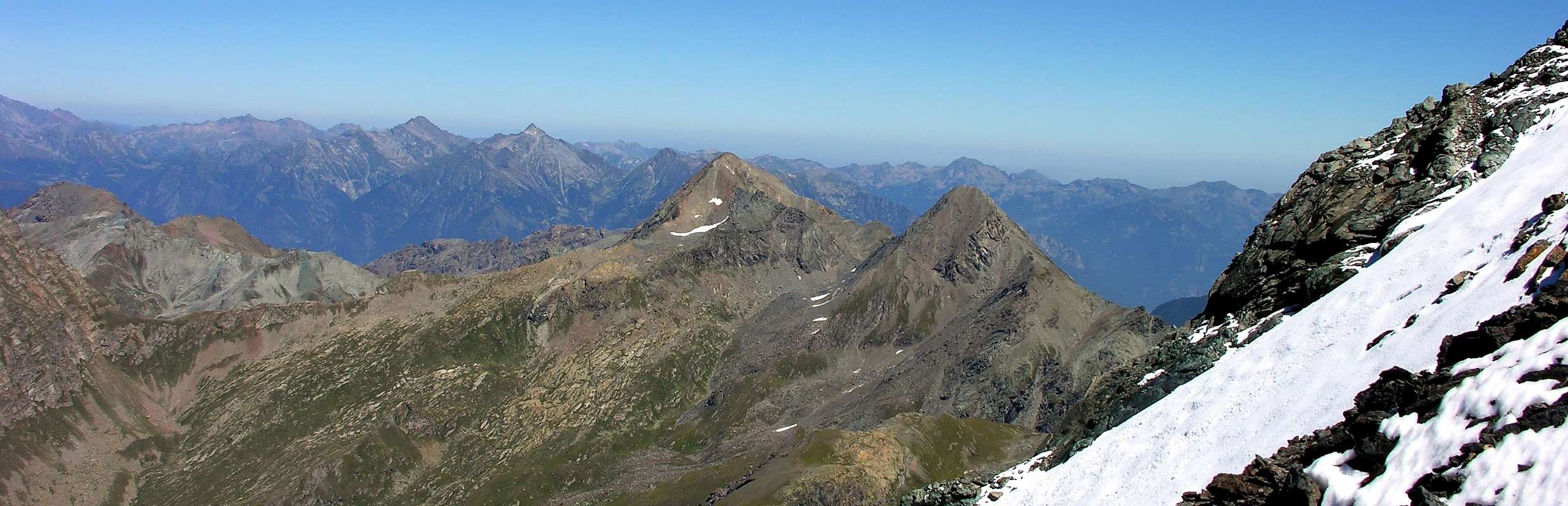
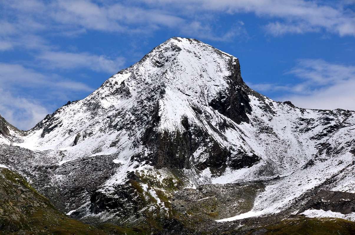
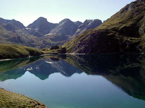
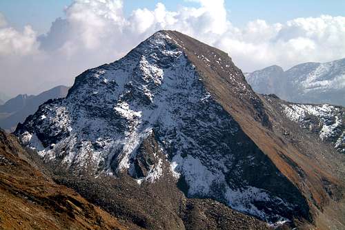
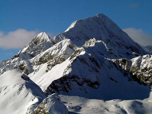
Important pyramid visible on Champorcher Valley, even from Chief Town Chateau, between the Pass Fussì (2.972m) (Northeast) and Moussaillon (2.858m) (Southwest) immediately to the Southwest of more high Mont Glacier (3.186m), on horse of the Champorcher Valley and Fénis-Clavalité Vallon. This mountain, beautiful and elegantly slender when viewed from the South, is more "squat" on the opposite side directed towards the Clavalité-High Comba Tersiva. It does not have glaciers and its four walls, lined with many ridges, are all composed of crumbly rock, broken and often covered with dangerous debris. The Way of Normal salt side of the Ridge Southwest coming from the Moussaillon Pass but runs completely the same as "interrupted" by a large vertical wall a hundred feets rests just to the right of the same on the South Side of reaching the terminal the same, whence the Summit. Analyzing clockwise, one linear Northwest corner divides the rocky-grassy Face West from the rotten North Face, formed by steep and rocky terrain with ledges suspended material; both are aimed at High Vallon Fénis, as the next Pass Fussì that acts as a link between this vallon and an annexe above the upper Village Dondena in Champorcher Valley. This is certainly how the second busiest via, although it does have some passages a little more difficult and exposed and requires the research steps with some workarounds to the right on the Northern Face, you need to know to locate. This Ridge, or the Northeast, separated from the Vallon of the Lac Gelé on the Normal Route to the Mont Glacier. On this side goes high and steep East Face, formed by rocks more compact but also covered with layers of grass; probably has been climbing one and only time in August 1900. This slope actually splits into two parts: one more to the North that surely coincides with the ascent above (see second picture below on his left); the other, delimited by a hard edge, is composed of a wall facing more towards Southeast, the ascent of which should not be at all easy. On the left is bounded by an another steep South Edge that it knows a single ascent in 1918 by Don Filiberto Noussan, Pastor of Champorcher. After that you turn up the North Slope that ends with the crest of which we spoke at the beginning. Size by steep grassy slopes encircling it at the base, in the upper part becomes more rocky and steep. The last 200 meters are made up of an elegant and very steep little wall; unfortunately, the formation of the rock, composed by brittle flakes covered with debris, allowing climbing more dangerous and delicate and difficult. Would not recommend, as incidentally all other routes of ridges or walls, except for the two most common ways. Certainly a lot less crowded near the Mont Glacier, since this has a way of rising much more simple and easy, while the Mont Delà, while not as difficult, always presents obstacles to be faced with some caution and also forces in search of the steps to be carried out both on the two Ridge Southwest and Northeast. Excellent landscape on the close Glacier, Tersiva, Rosa dei Banchi, but the view 360° view of the entire Aosta Valley to "loss of sight" to the East-northeast on the Po Valley.
Importante piramide ben visibile dall'abitato di Champorcher tra i Colli Fussì (2.972 m) (Nordest) e Moussaillon (2.858 m) (Sudovest) subito a Sudovest del più alto Mont Glacier (3.186 m), a cavallo delle Valli di Champorcher e Fénis-Clavalité. Questa montagna, bella ed elegantemente slanciata se vista da Meridione, appare più "tozza" sull'opposto versante indirizzato verso l'Alta Comba Tersiva. Non possiede ghiacciai e le sue quattro pareti, delimitate da altrettante creste, sono tutte composte da roccia friabile, rotta e spesso ricoperta da detriti pericolosi. La Via Normale sale a fianco della Cresta Sudovest che proviene dal Colle Moussaillon ma non percorre integralmente la medesima poiché "interrotta" da un grande salto verticale d'una sessantina di metri; si appoggia appena a destra dello stesso sul Versante Meridionale raggiungendo la parte terminale della stessa, donde alla Sommità. Analizzando in senso orario, uno Spigolo lineare Nordovest divide il roccioso-erboso Versante Ovest dalla Parete Nord, frormata da ripide rocce rotte e cengie con materiale sospeso; entrambi sono rivolti all'Alto Vallone di Fénis, come il successivo Colle Fussì fungente da collegamento tra questo vallone ed uno secondario sopra il Villaggio di Dondena in Valle di Champorcher. Questa risulta sicuramente come la seconda via più frequentata, anche se presenta qualche tratto leggermente più difficile ed esposto e necessita della ricerca dei passaggi con alcuni aggiramenti a destra. Questa Cresta, o Nordest, separa dal Vallone del Lac Gelé sulla Via Normale per il Mont Glacier. Su questo lato scende un'alta e ripida Parete Est, formata da rocce più compatte ma anche ricoperte da strati erbosi; probabilmente é stata salita una sola ed unica volta nello Agosto del 1900. Questo versante in realtà si sdoppia in due parti: uno più a Settentrione che sicuramente coincide con la salita di cui sopra (vedi foto sotto sulla sua sinistra); l'altra, delimitata da un arduo spigolo, é composta da una parete rivolta più verso Sudest, la salita della quale non deve essere per nulla facile. Sulla sua sinistra viene delimitata da un altro ripido Spigolo Sud che anch'esso conosce un'unica ascensione nel 1918 da parte di Don Filiberto Noussan, Parroco di Champorcher. Dopo questo si alza il Versante Sud concludentesi con la cresta di cui abbiam parlato all'inizio. Formato da ripidi pendii erbosi che lo cingono alla base, nella parte superiore diventa sempre più roccioso nonché ripido. Gli ultimi 200 metri sono costituiti da una elegante ed alquanto ripida paretina; purtroppo la costituzione della roccia, formata da scaglie fragili ricoperte da detrito, consente un'arrampicata più pericolosa e delicata che non difficile. Sconsigliabile, come daltronde tutti gli altri itinerari di pareti o creste, escluse le due vie più comuni. Sicuramente molto meno frequentata del vicino Mont Glacier, poiché questo presenta una salita molto più semplice e facile, mentre il Mont Delà, pur non essendo così difficicile, presenta sempre degli ostacoli da affrontare con una certa cautela ed obbliga anche alla ricerca dei passaggi da effettuare sia sulla Cresta Sudovest che sulla Cresta Nordest. Ottimo panorama sui vicini Mont Glacier, Tersiva e Rosa dei Banchi, ma la vista spazia a 360° sull'intera Valle d'Aosta "sperdendosi" verso Est-nordest sulla Pianura Padana.
First Ascent
First on the summit from Fussi Pass?: Abbot Pierre Chanoux, (1848).
In winter: Unknown.
S-SW Slope: Engineer Paganini?
S Arête: Abbot Champorcher Filiberto Noussan, (1918).
S-SE Wall (direct line): Osvaldo Cardellina, solo, (Jun 24th, 2001), in ascent from Dondena Hamlet; in descent through Southwestern Crest and Southern Slope (or Normal Route from Dondena Hamlet) with Emilio Bertona and Gianfranco Vicentini to Dondena.
W-SW Arête: Giovanni Bobba? From Moussaillon Hill?
W-SW Face (Right Sector) and W-SW Ridge: Osvaldo Cardellina and Alessandro Cardellina (Nov 01th, 2011), in ascent from Grand'Alpe, Cuneux Pasture and Tramail of Cuneus; in descent with Southwestern (with Tête de Cuneux 3.006 meters) Crest to Moussaillon Pass, Egidio Borroz Rotary Club Bivouac, Grand'Alpe.
NW Edge: Osvaldo Cardellina, lone (Aug 22th, 2006), in ascent from Grand'Alpe, Cuneux Pasture and Tramail of Cuneus; in descent with Southwestern Crest (bypassing Tête de Cuneux 3.006 meters) to Moussaillon Pass, Egidio Borroz Rotary Club Bivouac, Grand'Alpe.
N Wall (Left or Eastern Sector): Andrea Bastrentaz and Paolo Zappa, (Jun 16th, 1986).
N Wall (Right or Western Sector): Osvaldo Cardellina, lone, (Aug 01th, 2011), in ascent from Grand'Alpe, Cuneux Pasture and Cuneus Tramail; in descent through Northeastern Crest to Col Fussì and traverse to Mont Glacier through SW Slope or Normal Via.
NE Arête (from Fussi Pass): unknown.
E Face: Nicola Vigna, Achille Ambrogio Damiano Ratti e Giulio Toesca di Castellazzo (Aug 21th, 1900).
Getting There
BY CAR:
From Torino, Milano, etc: Motorway A5. Exit Pont Saint Martin for then to continue on SS.26 toward Hone Bard.
From Switzerland: through the Grand Saint Bernard Tunnel or the namesake pass. Drive to Aosta, Verrès and Hone Bard..
From France: through Mont Blanc Tunnel or Petit Saint Bernard Pass. It isn't necessary to take Motorway A5: you can drive on SS.26, in the direction of Aosta and Verrès and Hone Bard.
BY PLANE:
Aeroporto "Corrado Gex" Saint Christophe (Aosta).
Road Itinerary & Approach
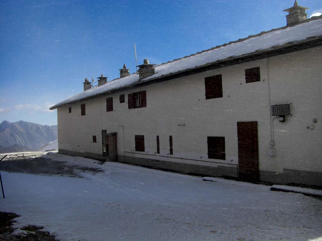
If you take the motorway, exit in Pont San Martin and follow the direction Aosta along the normal route; take care after Donnas: right side, immediately after the village, you can see approx. 100 meters of the Roman Consular Road and a nice arc. A few hundreds meters after the Bard Fortress there is a bridge left side, over the Dora Baltea River, with the indication Champorcher; follow it. Drive a few km, till the village of Chateau, and look right side for the indication Petit Mont Blanc. Follow this road, not too large, for a lot of km. Part is asphalted, the most part no. Usually the conditions of this second part are good, ask in the area. Follow this road (old Royal Road) till small Dondena Village. At the end a sign forbids the traffic after the parking; there are 3/4 parking area, but the road is steep and demaged; take care and park in the upper one. When you start walking, you will find a table with the indications, and the map of the area. Come down left till the river, pass over the bridge and along the road arrive to the Refuge of Dondena(2.200m).
Utilizzando l'autostrada, uscire a Pont San Martin e seguire la direzione verso Aosta lungo la Strada Regionale; prestare attenzione subito dopo Donnas: sul lato destro si posson ancora ammirare circa 100 metri della strada Consolare Romana ed un bellissimo arco. A poche centinaia di metri dopo il Forte di Bard c'è sul lato a sinistra del ponte, sopra la Dora Baltea, l'indicazione per Champorcher; seguirla. Salire in auto per alcuni kilometri, fino al Villaggio di Chateau, e cercare sulla destra l'indicazione per il Villaggetto del Petit Mont Blanc. Seguire questa strada, non troppo grande, per alcuni kilometri. La stessa é in parte asfaltata, ma per la maggiore é fatta in terra battuta. Di solito le condizioni di questa seconda parte sono abbastanza buone ma é meglio informarsi in zona. Seguire la medesima, coincidente con la vecchia Strada Reale, fino al piccolo Villaggio di Dondena. Alla fine della medesima un cartello indica il divieto di traffico, subito appresso al parcheggio. Questo é alquanto limitato sulla ripida e ristretta strada, per cui risulta meglio risalire a quello di poco superiore. Quando s'inizia a camminare trovate un pannello con le varie indicazioni, nonché la cartina della zona. Scendere in breve tempo al sottostante Torrente Ayasse ed attraversarlo sopra il ponticello, dopodiché lungo la strada sterrata s'arriva al Rifugio di Dondena(2.200).
Route
From Dondena (2.110m) to follow the "Strada Reale" for the Window of Champorcher until the small bridge that go through the Torrent Ayasse. To continue long the path for the Pass of Moutsaillon (leaving to Northeast that for the "Mont Glacier"). To leave it to contribution 2.800m~ aiming directly on grassy slopes steep, to the terminal part of the Southwest first climbing about in the middle of the slope, under the small South Face, and then gradually bending to the left (Northwest) until you reach the base of the same altitude of 3.000 meters~. Leaving on the left the big jump of ~100 meters, it is estimated almost on its margin right through a small track and on steep, rotten and small rocks (I°; this stretch is not difficult but it is quite exposed and requires a bit of caution) to reach the real thread of the Southwest Ridge, where this is directed at an oblique angle to the East to about eighty meters from the Summit. Easily and quickly arrive with more linear path to the stone cairn of the Top (3h'00/3h'15). Note: not keep too right on the rocks of small South Face, because the same, that appear to "inviting", are made of cast somewhat fragile and dangerous, as well as covered with fine debris.
Descent: on the same route.
Da Dondena (2.110 m) seguire la Strada Reale per la Finestra di Champorcher sino al ponticello che attraversa il Torrente Ayasse. Proseguire lungo il sentiero per il Colle di Moutsaillon (abbandonando a Nordest quello per il Mont Glacier). Lasciarlo a quota 2.800 metri circa puntando direttamente su pendii erbosi ripidi, alla parte terminale della Cresta Sudovest; dapprima salendo circa al centro del pendio, sotto la Parete Sud, e poi piegando progressivamente verso sinistra (Nordovest) fino a raggiungere la base della medesima in altitudine di 3.000 metri~. Lasciando sulla sinistra il grande salto di 100 metri~, lo si aggira quasi sul suo margine destro tramite una piccola traccia e su roccette ripide e rotte (I°; questo tratto non é difficile ma risulta abbastanza esposto e richiede un poco di cautela) raggiungere il vero filo della Cresta sudovest, dove questa si indirizza in modo obliquo verso Est a circa una ottantina di metri dalla Sommità. Risalendo questo tratto terminale di cresta, pressocché camminabile, facilmente ed in breve tempo arrivare al grande ometto in pietra presso la Vetta (3h'00/3h'15). Nota: non tenersi troppo a destra sulle rocce della Faccia Sud, perché le stesse, che all'apparenza sembrano "invitanti", sono costituite da scagli alquanto fragili e pericolose, nonché ricoperte da fine detrito; per cui, avendo iniziato troppo verso il centro, conviene riportarsi quanto prima a sinistra cioé verso la suddetta descrizione.
"Guida delle Alpi Occidentali" di Giovanni Bobba e Luigi Vaccarone C.A.I. Sezione di Torino Volume II (parte II), 25 Maggio 1896.
"Guida dei Monti d'Italia–Emilius Rosa dei Banchi Parco del Mont Avic" di Giulio Berutto e Lino Fornelli-Club Alpino Italiano/Touring Club Italiano, Marzo 2005 (in Italian).
"I Rifugi della Valle d'Aosta" di Stefano Ardito, Ed. Guide iter, Febbraio 2003.
"Guida della Regione Autonoma Valle d'Aosta" di Mario Aldrovandi; Ed. S.P.E. di Carlo Fanton, Torino 1964.
"Diari Alpinistici" di Osvaldo Cardellina e Indice Generale accompagnato da Schedario Relazioni Ascensioni 1964-2019 (inediti).
MAPS:
Enrico Editore Ivrea-Aosta "Gruppo del Gran Paradiso" 1:50.000.
I.G.C. Istituto Geografico Centrale Torino "Ivrea Biella e Bassa Valle d’Aosta" (n° 9), 1:50.000.
L'Escursionista "Valle di Cogne Carta dei Sentieri" 1:25.000.
Parents refers to a larger category under which an object falls. For example, theAconcagua mountain page has the 'Aconcagua Group' and the 'Seven Summits' asparents and is a parent itself to many routes, photos, and Trip Reports.

 6237 Hits
 84.82% Score
 19 Votes