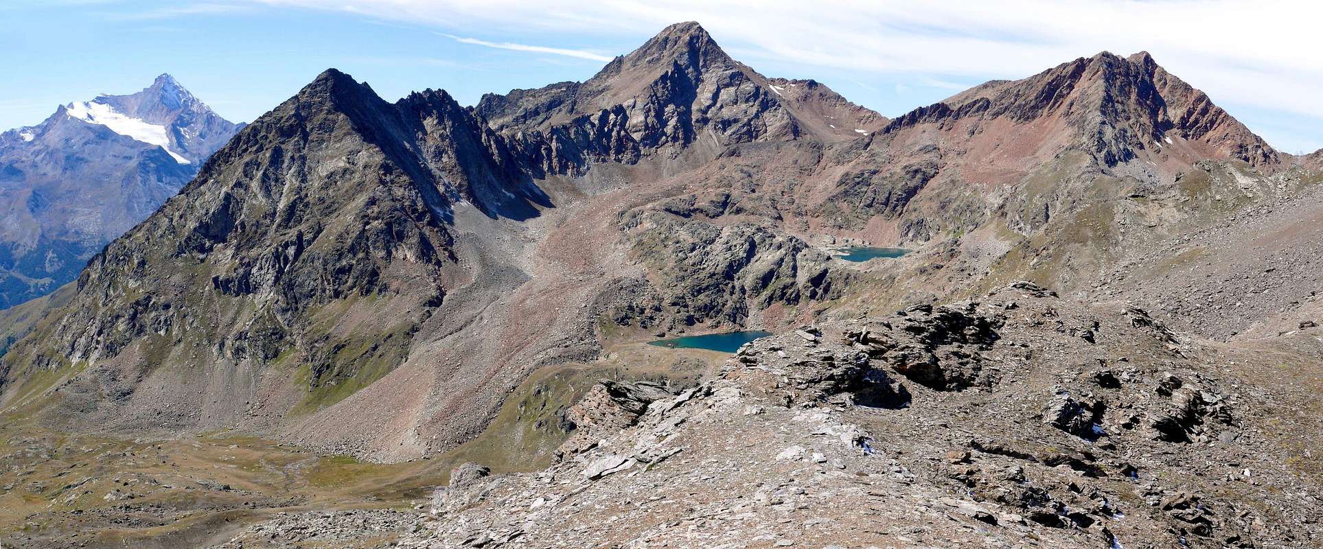
This seemingly small mountain, the altitude is not irrelevant, it remains hidden from the mass of the Top Leppe (3.305/6m) that rises immediately to the North partially occluding the view in that direction; however, the same with great glances, rising from the Hill of Saint Marcel towards Mont Velan, Grand Combin, Grande Roise, Matterhorn and Monte Rosa in that direction, while in the South it opens, like a large fan, on groups of the Mount Avic, Glacier-Delà, Punta Tersiva then advancing on a much larger amphitheater from the Tower of Lavina reaches the Gran Paradiso and the nearby Grivola. Not very busy, generally is bypassed during the climb to Leppe or returning from it. But it can be nice outing in itself departing from Grande Chaux, Grauson New Pasture or neighbor Corona Lake, especially in the beginning of the season when the snow is still too high and to limit the ascent to higher altitudes. Situated on the watershed between the Walloons of Grauson/Lussert (Cogne) and Saint Marcel, has a decidedly debris Western slope toward the first and a steep slope of broken rock against the second; both are to be avoided as boring, tiring and very low remuneration. The ridge hike instead, as well as scenic is nice and is also suitable for trips with snowshoes between the two paths in the crest is preferable that, although slightly longer, which comes from the Hill of Saint Marcel, while the opposite via the Col Vallonet is a little faster but certainly less rewarding.
Quest'apparentemente piccola montagna, dall'altitudine non irrilevante, rimane occultata dalla massa della Punta di Leppe (3.305/6 m) elevantesi immediatamente verso Settentrione occludendo parzialmente la vista in quella direzione; ciononostante la medesima spazia, salendo dal Colle di Saint Marcel, sul Mont Velan, Grand Combin, Grande Roise, Cervino e Monte Rosa in quella direzione, mentre a Mezzogiorno s'apre a guisa di gran ventaglio sui Gruppi dell'Avic, Glacier-Delà, sulla Punta Tersiva per poi inoltrarsi su un ben più ampio anfiteatro che dalla Torre di Lavina raggiunge il Gran Paradiso e la vicina Grivola. Non molto frequentata, in genere viene scavalcata durante la salita alla Leppe o di ritorno dalla medesima; ma può costituire simpatica gita a se stante con partenza da Grande Chaux, dall'Alpe Grauson Nuove o dal viciniore Lago Corona, soprattutto in inizio di stagione quando la neve è ancora troppo alta e tale da limitare l'ascensione a più elevate quote. Situata sullo spartiacque tra i Valloni di Grauson/Lussert (Cogne) e di Saint Marcel, presenta un versante Ovest decisamente detritico verso il primo ed una ripida scarpata di rocce rotte nei confronti del secondo; entrambi sono da evitarsi poiché noiosi, faticosi e di ben scarsa remunerazione. La traversata in cresta invece, oltre che panoramica, risulta piacevole e si presta anche a gite con racchette da neve; tra i due percorsi in cresta è preferibile quello, anche se appena più lungo, che proviene dal Colle di St. Marcel, mentre l'opposto tramite il Col Vallonet è un poco più rapido ma sicuramente meno gratificante.
First Ascents
First on the summit: Unknown.
In Winter: Unknown.
Getting There
BY CAR:
From Torino, Milano, etc: Motorway A5. Exit in Aosta Ovest. Drive to the near Aymavilles. Follow in the direction of Valle di Cogne.
From Switzerland: through the Grand St. Bernard Tunnel or the homonym Pass). Drive to Aosta, then follow Courmayeur direction on SS.26. Just after Sarre, turn to the left, in the direction of Valle di Cogne.
From France: through Mont Blanc Tunnel or Petit St. Bernard Pass). It isn't necessary to enter in Motorway A5, you can drive through SS.26 Aosta direction. Before arriving at the Village of Sarre, follow the sign and turn right towards Valle di Cogne. After Aymavilles, the SR.47 crosses the Villages of Vieyes, Epinel and Cretaz and after about 25 Km. arrives at Cogne (1.534m). Follow the road signs for Gimillan and Lillaz; arrived at a round-about, recently built in proximity of the St. Anthony Chapel, go left along the scenic route leading to the Village of Gimillan (1.787m), 3 Km. after Cogne. Usually no parking problem.
BY PLANE:
Aeroporto "Corrado Gex" Saint Christophe (Aosta).
Approach
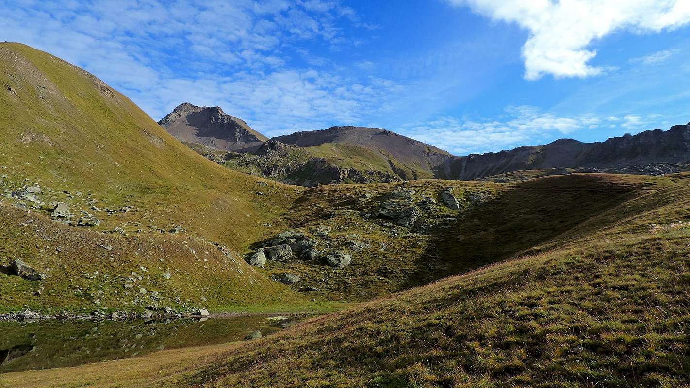
To follow departing from the Parking lot 1.744 meters of Gimillan, nearby the with the same name (or from the bridge in wood I immediately approach to quota 1.800 meters around that it brings dirt road "poderale" to the new road for then to rejoin him with the path as soon as before the ruins of Alp Tarabouc; * characteristic little chapel), the road for the Tersiva (3.515m) along the Walloon of the Grauson through the path n° 8 reaching following, after a brief but steep descent, the small Bridge of the Ecloseur (1.903m; The Weir) on the Torrent Lussert/Grauson, otherwise says Torrent Gru, for the reunification of a whole series of brooks and small torrents, and, through a long diagonal in the middle of beautiful lawns after the 2000 flood, the following Pila Pasture with beside a splendid fall (2.021m); leaving 2.003 meters to quota the deviation non numbered for this last a little before, to always continue instead toward North dominating from the tall one a series of little falls, creating the same aforesaid. Doubling on the left the following round promontory rocky 2.156 meters, with the path characterized by a series of steps in iron, to mostly address him toward Northwest bringing himself in a little valley that he goes up again with some small and steep hairpins bends and going out on the impending upland. With the signal of the trail, through a long diagonal along the wood and dominating from notable height the fund of the walloon, to arrive so to the fork for the Alp Crouzet (2.244m)"perched" on the edges of the Torrent de Lussert, but not to reach it; to the following alternative 2.296 meters, entering the beautiful tableland of Grauson Vecchie (Old), I immediately approach to a cross to leave on the right the path n° 8, that it climbs to the Lake of Money (2.550m), and to reach this alp (2.273m; good point of standstill; rising Pré-Vaudan in the lawn as soon as to side of the small gangway for the pasture). From this, returning to the path "mother", through the same to enter a small throat that races at the base of the Southern Slope of the Tête Praz de Ler (2.526m) and to entirely cross it reaching a second small bridge, says of Pikaciù; abandoning to the right (East) the prosecution of the path n° 8, that it is addressed to the Alps of Pralognan and Erveillères also Ervillères in the Walloon of Doreire, to continue instead toward North with the path n° 8 and, with a wide hairpin bend, to reach the Log Cabin of the Hunters (2.479m; fountain; beautiful frontal views on the Subgroup of the Penne Blanche, on the back Grauson Tower and in distance to East on the Point Tersiva) and, crossing the rump of the following grassy back, to reach to Grauson Dessus or New (2.540m; rising), near the old Shelter Tentori by now nonexistent, since gone to fire in June of 2001. From this point, surrendering to North the path that continues toward the four splendid Lakes of Lussert and the Hill of Laures, to continue toward East-southeast with the path n° 8 crossing a zone, that her out exit the rivulets of the torrent makes marshy; with a wide hairpin bend seeds circular to reach a tiny loch, said of the Frogs (2.641m; poster in wood) passing it on its Southern shore. Gradually to go up again the impending grassy promontory debris on his thread and to reach with a small deviation, on path, the well greater Corona Lake (2.702m; T; 2h'15/2h'30; deserving of visit and standstill to photographic purpose, as well as destination of trip for herself). Returning to the path basic of, continuous to decidedly changing direction in East-northeast crossing in zones characterized by stony ground, followed from a small basin; with to last steep line, where the path becomes minuscule climbing on soil subject to landslides, to reach the Hill of Saint Marcel or Coronas (2.913/6m; E; in total 3h'00/3h'30).
VARIANT: from Grauson Dessus (Tall) Pasture, or from the junction just beyond the Lago Corona via a connecting trail to the Northwest with the Lower Lake Lussert (2.713m), continue towards the North, reaching the Torrent de Lussert and immediately after the Tsesère Alp (2.645m; beautiful stone fountain), located in a narrow and small walloon; following the same reach the junction with the previous path from Lake Corona (E; 0h'30/0h'40).
Seguire partendo dal Parcheggio 1.744 m di Gimillan, presso l'omonimo torrente (oppure dal ponte in legno subito appresso a quota 1.800 m~ che porta alla nuova strada poderale per poi ricongiungersi con il sentiero appena prima dell'Alpe di Tarabouc; * chiesetta caratteristica), la strada per la Punta Tersiva (3.515 m) lungo il Vallone del Grauson tramite il sentiero n° 8 raggiungendo di seguito, dopo una breve ma ripida discesa, il Ponticello dell'Ecloseur (1.903 m; La Chiusura) sul Torrent Lussert/Grauson, altrimenti detto Torrent Gru, per la riunificazione di tutta una serie di torrenti e torrentelli, e, tramite un lungo diagonale in mezzo a bei prati bonificati dopo l'alluvione del 2000, la successiva Alpe di Pila con a fianco una splendida cascata (2.021 m); lasciando poco prima a quota 2.003 metri la deviazione non numerata per quest'ultima, continuare invece sempre verso Settentrione dominando ben dall'alto una serie di cascatelle, originanti dabbasso la predetta. Doppiando sulla sinistra il successivo tondeggiante promontorio roccioso 2.156 metri, con il sentiero-mulattiera caratterizzato da una serie di gradini-puntoni in ferro, indirizzarsi maggiormente verso Nordovest portandosi in un valloncello che si risale con alcuni ripidi tornantini ed uscendo fuori sul pianoro soprastante. Dopo il cartello con segnavia, con un lungo diagonale attraverso il bosco e dominando da notevole altezza il fondo del vallone, arrivare così al bivio per l'Alpe Crouzet (2.244 m) "appollaiata" sui bordi del Torrent de Lussert, ma non raggiungerla; al successivo bivio 2.296 metri, entrando nel bel pianoro di Grauson Vecchie, subito appresso ad una croce lasciare sulla destra il sentiero n° 8C, che sale al Lago di Money (2.550 m), e raggiungere quest'alpeggio (2.273 m; ottimo punto di sosta; sorgente Pré-Vaudan nel prato appena a lato della passerella per l'alpe). Da questa, ritornando al sentiero "madre", tramite lo stesso entrare in una goletta che corre alla base del Versante Meridionale della Tête Praz de Ler (2.526 m) e percorrerla interamente raggiungendo un secondo ponticello, detto di Pikaciù; abbandonando a destra (Est) la prosecuzione del sentiero n° 8, indirizzantesi alle Alpi di Pralognan e di Erveillères nel Vallone Doreire, continuare invece verso Nord con il sentiero n° 8B e, con un largo tornante, raggiungere la Baita dei Cacciatori (2.479 m; fontana; belle vedute frontali sul Sottogruppo del Penne Blanche, sulla retrostante Tour Grauson ed in lontananza ad Oriente sulla Punta Tersiva) e, percorrendo la groppa del dosso erboso successivo, pervenire a Grauson Dessus o Nuove (2.540 m; sorgenti), presso il vecchio Rifugio Tentori ormai inesistente, poiché andato a fuoco nel Giugno del 2001. Da questo punto, abbandonando a Settentrione il sentiero che continua verso i quattro splendidi Laghi di Lussert ed il Col des Laures, proseguire verso Est-sudest con il sentiero n° 8 attraversando una zona, che la fuoruscita dei rivoletti del torrente rende alquanto paludosa; con un largo tornante semi circolare raggiungere un laghetto, detto delle Rane (2.641 m, cartello in legno) passandolo sulla sua riva Meridionale. Gradualmente risalire il soprastante promontorio erboso detritico sul suo filo e raggiungere con una piccola deviazione tramite sentiero, il ben più grande Lago Corona (2.702 m; T; 2h'15/2h'30; meritevole di visita e sosta a scopo fotografico, nonché meta di gita per se stessa). Ritornando al sentiero di base, continuare cambiando decisamente direzione in Est-nordest attraversando una zona caratterizzata da scoscese pietraie, seguita da un valloncello-conca; con un ultimo tratto più ripido, dove il sentiero diventa minuscolo salendo su terriccio franoso, raggiungere il Colle di Saint Marcel o Col Coronas (2.913/6 m; E; nel totale 3h'00/3h'30).
VARIANTE: dall'Alpe Grauson Dessous, oppure dal bivio poco oltre il Lago Corona tramite un sentiero di collegamento a Nordovest con il Lago Inferiore di Lussert (2.713 m), continuare verso Settentrione raggiungendo il Torrent de Lussert e subito dopo l'Alpe isolata di Tsesère (2.645 m; bella fontana in pietra), posta dentro uno stretto valloncello; seguendo il torrente raggiungere l'incrocio con il precedente sentiero dal Lago Corona (E; 0h'30/0h'40).
Routes
A) - from the Hill of Saint Marcel Col also Col Corona (2.913m; small statue placed in bluish "pietra ollare" or soapstone) complex that leave the path descends into the Vallon Fenêtre in the Valley of Saint Marcel, and turning decidedly to the North, continue on the watershed Grauson/Saint Marcel; you pass on the right (East) some brownish rough rock (2.929, 2.991 meters) and through the South-southeast ridge, the Summit can be reached easily (E; 0h'45/1h'00 from hill; 1h'45/2h'00 from Grauson New Pasture; 4h'00/4h'30 by Gimillan).
A) - dal Colle di Saint Marcel o Col Corona (2.913 m; piccola statua inserita nella bluastra pietra ollare) abbandonare il sentiero intervallivo che scende nel Vallon Fenêtre nella Valle di Saint Marcel e, volgendo decisamente verso Nord, proseguire sullo spartiacque Grauson/Saint Marcel; oltrepassate sulla destra (Est) alcune brunastre asperità rocciose (2.929, 2.991 metri) e tramite la Cresta Sud-sudest, facilmente si raggiunge la Sommità (E; 0h'45/1h'00 dal colle; 1h'45/2h'00 da Grauson Nuove; 4h'00/4h'30 da Gimillan).
B) - from the intersection with the trail connecting Lake Corona/Lake Lower Lussert (about 2.735/40 meters) abandon the same at the headwaters of the torrent itself, and gradually turning towards the Northeast, reaching a large stony supported at the base by a small and characteristic castle with reddish rocks located between the points 2.883/2.921 meters; pass before (North) that reaching a small debris basin at the foot of the Col Vallonet (3.062m), located between the Mount of the same name and the Crest East-southeast of the Punta Leppe (3.305m). Go up the last stretch of dirt track through a progressively steep landslide quickly reaching but the painfully pass, on the opposite side falls in the Grand Vallon above Grande Chaux (2.370m) in the Valley of Saint Marcel. From the narrow passage, through the Northwest Crest, easily reach the Summit (E; 1h'00 /1h'15 from intersection; 1h'30/2h'00 from Grauson New Pasture; 4h'30/5h'00 by Gimillan).
B) - dall'incrocio con il sentiero di collegamento Lago Corona/Lago Inferiore di Lussert (2.735/40 metri circa) abbandonare lo stesso presso le sorgenti del torrente medesimo e, volgendo progressivamente verso Nordest, raggiungere una grande pietraia sostenuta alla base da un caratteristico castelletto di rocce rossastre sito tra i punti 2.883/2.921 metri; passare a monte di questo raggiungendo una piccola conca detritica ai piedi del Col Vallonet (3.062 m), posto tra l'omonima punta e la Cresta Est-sudest della Punta di Leppe (3.305 m). Salire l'ultimo tratto tramite una ripida traccia di terriccio progressivamente sempre più franoso raggiungendo in breve tempo ma faticosamente il colle, che sul versante opposto scende nel Gran Vallon sopra Grande Chaux (2.370 m) in Valle di Saint Marcel. Dallo stretto passo, tramite la Cresta Nordovest, raggiungere facilmente la Sommità (E; 1h'00/1h'15 dall'incrocio; 1h'30/2h'00 da Grauson Nuove; 4h'30/5h'00 da Gimillan).
Difficulty
For Hikers (F or Easy), suitable to the Ski-Mountaineering and Snowshoeing.
Escursionistico (F), adatto anche allo Sci-Alpinismo ed alle Racchette da neve.
Essential Gear
Hiking gear.
Da Escursionismo.
Campings
Remember that free camping is forbidden (except for emergency reasons, over 2.500m, from darkness until dawn).
Mountain Conditions
You can get meteo information at the official site of the Regione Valle d'Aosta:
"Guida delle Alpi Occidentali" di Giovanni Bobba e Luigi Vaccarone C.A.I. Sezione di Torino Volume II (parte II), 25 Maggio 1896.
"Guida dei Monti d'Italia – Emilius Rosa dei Banchi-Parco del Mont Avic" di Giulio Berutto e Lino Fornelli - Club Alpino Italiano/Touring Club Italiano, Marzo 2005.
"Diari Alpinistici" di Osvaldo Cardellina e Indice Generale accompagnato da Schedario Relazioni Ascensioni 1964-2019 (inediti).
MAPS:
Ingenia "Parco Naturale del Mont Avic" Carta dei sentieri 1:25.000.
Enrico Editori Ivrea "Carta turistica del Canavese" 1:100.000
Enrico Editore Ivrea-Aosta "Gruppo del Gran Paradiso" 1:50.000.
L'Escursionista editore "Valle di Champorcher Parco Mont Avic" Carta dei Sentieri (11) 1:25.000.
L'Escursionista "Valle di Cogne" Carta dei Sentieri 1:25.000.
Carta Hapax Escursionistica della Comunità Monte Emilius, 2° Edizione 2008 1:25.000.
I.G.C. di Torino "Ivrea Biella Bassa Valle d'Aosta" Carta dei sentieri e rifugi n° 9 1:50.000.
Parents refers to a larger category under which an object falls. For example, theAconcagua mountain page has the 'Aconcagua Group' and the 'Seven Summits' asparents and is a parent itself to many routes, photos, and Trip Reports.

 3636 Hits
 82.48% Score
 15 Votes