
-
 11484 Hits
-
 89.77% Score
-
 30 Votes
|
|
Mountain/Rock |
|---|---|
|
|
45.66230°N / 7.41646°E |
|
|
Mountaineering |
|
|
10846 ft / 3306 m |
|
|
Overview
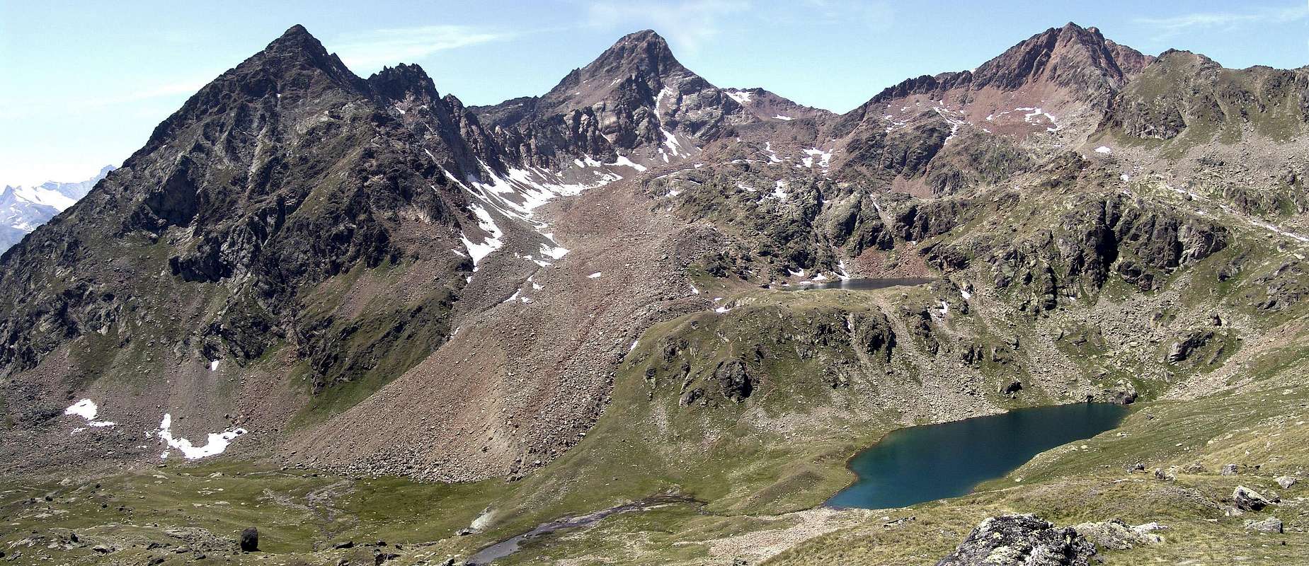
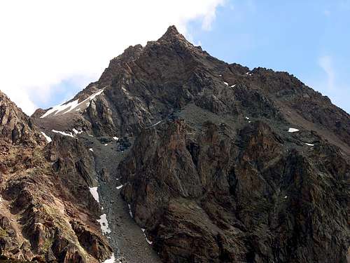
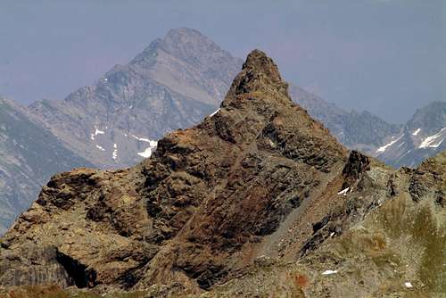
The Punta di Leppe (once named Becca di Leppy) or, as locally known, Punta del Piccolo Vallone (Small hanging-valley summit) is a truncated pyramid made of three small summits. It has four ridges delimiting four sides whose Northern one is divided in two parts, more precisely North and Northwest, by a small and low prominent Edge toward North-northwest. Another ridge, well sketched above the Alp of Grande Chaux, rises between the hanging small valleys named Petit Vallon (small, to the West), and Grand (big, to the West-southwest), making an hardly distinguishable division between the next Oriental and more in Southeast sides. But the "main" ridge or watershed between the Valleys of Saint Marcel to the East and those of Grauson/Lussert and Laures West is aligned along the axis of the South/North, from the large Hill of Saint Marcel (starting from Punta Tersiva for onward transit over The Tops of Tessonet, Gianni Vert, two of Laval and Mount Vallonet) to that of Leppe (which precedes the Punta Ilario Antonio Garzotto, the Chain of Roises and ending at the Becca and Tower of Salé above the Brissogne Municipality). The first part is addressed, from the Top Tersiva to the Leppe, more towards the Southwest in the direction of the important Cogne Valley; the next by the latter arrives at Salé instead declines to the North-northeast and its waters feed the two Lakes Laures which then flow up to the Dora Baltea in the Central Valley. A last crest, perpendicular to the watershed Saint Marcel/Brissogne/Cogne, form another partition along the East/West, designed to divide the heads of Grauson/Lussert South from Laures to the North. This ridge has a fairly unusual arrangement in relation to the existing media in Aosta Valley (emulated by those of Penne Blanche and Mont Glacier to the South and East-southeast). The same goes from Leppe to a large terrace that Lussert Pass, form the eponymous Summit and sloping gradually to the West, reaches the Mont des Laures and the nearby Laures Hill; from this point he gets up before reaching the more imperious Punta des Laures and then the Summit of the Eastern Punta Rossa, where, in a narrower sense, it is the source of the Group of Mount Emilius (3.559m), the highest elevation of this large area North of the Chain of Gran Paradiso. This ridge that descends with rocks so steep as the above routes Lussert Pass, splits itself is just below the Western Antesummit sending a short secondary branch that ends at a small Summit called Punta of Tsesère, which in turn projects a large rocky wall above Lower Lake Lussert; between the two branches, the mountain has the only wall worthy of the name. The North Slope, above the Glacier Leppe, which in the past offered a fun time climbing on hard snow it has now turned into a desolate slope of crushed rocks and debris. The other sides have long been even more remote and these characteristics do not offer any incentive or opportunity of climbing; on the other hand at the base of East Ridge, just above Grande Chaux, have been traced some short routes on pretty good rock, sparsely attended due to the distance from Les Druges Tall Village. But to access the same must possess a transit permit or provide for a long walk approach. Beautiful views over the valleys of Cogne Gran Paradiso in the South, while all around and the closest you can admire Glacier, Delà, Tersiva, Penne Blanche, Peak Garin, Red Summits, Mount Emilius and the Chain of Grande Roise; but it is mainly a series of beautiful lakes to draw the view, both from the side Laures that from opposite slope Lussert.
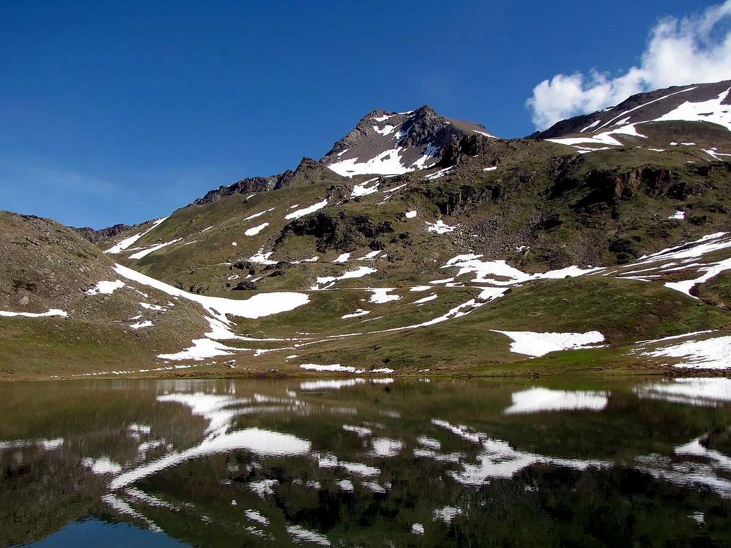
La Punta di Leppe (anticamente conosciuta come Becca di Leppy) o, chiamata in loco, anche Punta del Piccolo Vallone, è una piramide tronca al vertice, costituita da tre piccole elevazioni ravvicinate e con non grande differenza di altezza. Presenta quattro creste, atte a formare quattro versanti, dei quali quello Settentrionale è suddiviso in due parti, più precisamente Nord e Nordovest, da uno spigoletto scarsamente accentuato e con direzione Nord-nordovest. Un'altra cresta ben delineata sopra l'Alpe di Grande Chaux, sale a separare i due valloni chiamati rispettivamente Petit Vallon (ad Ovest) e Gran Vallon (ad Ovest-sudovest) andando a dividere in modo appena distinguibile i due congiunti Versanti Orientale e di Sudest. Ma la cresta "principale" o spartiacque tra i Valloni di Saint Marcel ad Est e quelli di Grauson/Lussert e di Laures ad Ovest si allinea lungo l'asse Sud/Nord, dal largo Colle di Saint Marcel (partendo dalla Punta Tersiva per poi transitare sopra le Sommità del Tessonet, Punta Gianni Vert, Punta di Laval e Mont Vallonet) a quello di Leppe (che precede la Punta Ilario Antonio Garzotto e la Catena delle Roises terminando alla Becca e Torre di Salé al di sopra del Comune di Brissogne). Una prima parte é rivolta, dalla Tersiva alla Punta di Leppe, più verso Sudovest in direzione dell'importante Valle di Cogne; la successiva che da quest'ultima arriva alla Salé invece declina a Nord-nordest e le sue acque alimentano i due Laghi delle Laures, che in seguito scorrono fino alla Dora Baltea nella Valle Centrale. Un'ultima cresta, perpendicolare allo spartiacque Saint Marcel/Brissogne/Cogne, forma un altro divisorio lungo l'asse Est/Ovest, atto a dividere le testate del Grauson/Lussert a Sud da quella delle Laures a Settentrione. Questa cresta presenta una disposizione abbastanza atipica in rapporto alla media esistente in Valle di Aosta (emulata da quelle del vicino Penne Blanche e del Mont Glacier più in lontananza verso Sud ed a Est-suddest). La medesima scende dalla Leppe verso una grande terrazza detta Colle di Lussert, forma l'omonima Sommità e, digradando progressivamente ad Ovest, raggiunge il Mont des Laures ed il vicino Colle des Laures; da questo punto si rialza più imperiosa raggiungendo prima la Punta des Laures e poi la Sommità Orientale della Punta Rossa, dove, in senso più ristretto, si origina il Gruppo del Monte Emilius (3.559 m), massima elevazione di questa grande area a Nord della Catena del Gran Paradiso. Questa cresta che scende con rocce tanto ripide quanto rotte sopra il Colle di Lussert, si sdoppia appena sotto l'Antecima Ovest inviando un breve ramo secondario terminante presso una piccola Sommità chiamata Punta di Tsesère, a sua volta proiettante una grande parete rocciosa sopra il Lago Inferiore di Lussert; tra le due diramazioni la montagna presenta l'unica parete degna di tal nome. il Versante Nord, sopra il Ghiacciaio di Leppe, che in passato offriva divertenti salite su neve dura s'é ora tramutato in desolante pendio di detriti e rocce frantumate. Anche gli altri versanti possiedono da tempo ancor più remoto queste caratteristiche e non offron nessun stimolo od opportunità d'arrampicata; per contro sullo zoccolo basale della Cresta Est, appena sopra Grande Chaux, son state tracciate alcune brevi vie su roccia abbastanza buona, scarsamente frequentate causa la lontananza da Les Druges. Ma per accedere alle stesse bisogna possedere il permesso di transito oppur prevedere di "sobbarcarsi" una piuttosto lunga camminata d'avvicinamento. Belle vedute su Cogne e le valli del Gran Paradiso a Sud, mentre tutt'intorno e più vicino si possono ammirare Mont Glacier e Delà, Punta Tersiva, Penne Blanche, Pic Garin, Punta Rossa, Monte Emilius e Catena della Grande Roise; ma sono soprattutto la serie di splendidi laghi ad attirare la vista, sia dal lato Laures che dall'opposto versante Lussert.
![Punta di Leppe North Face]()
First Ascents
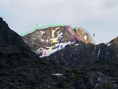
- First on the Summit: Giovanni Bobba and Eliseo Jeantet, (Aug 02th, 1893), in ascent from Grauson Valley through Vallonet Pass and by E-SE Crest.
- In winter: Unknown, but surely Ruggero Busa, Daniele Parini and Cesare Roullet, (Mar 31th, 1975), by ski-mountaineering ascent from Gimillan Hamlet.
- S-SE Arête: Giovanni Bobba and Eliseo Jeantet, (Aug 02th, 1893), in ascent from Cogne Commune through Grauson Vallon and Vallonet Pass.
- S Slope (between S-SE and S-SW Crests): Armando Bertucci and Giovanni Battista Bozzino, (Aug 18 th, 1910), in descent to Gimillan.
- S-SW Crest (to Tsesère Tip): Osvaldo Cardellina, lone, (Nov 15th, 2007), in descent with crossing to SW Face of Southern Antesummit.
- W Wall (of Western Antesummit around 3.285/90m): Osvaldo Cardellina, lone (Nov 15th, 2007), in ascent from Gimillan, Tsesère Alp.
- W-SW Arête (from the Collar about 3.084/94m): Agostino Ferrari and B. Glarey, (Sep 15th, 1898), in ascent with traverse to Roèses.
- W-SW Arête (Integral from Laures Pass): Osvaldo Cardellina, lone, (Jul 12th, 1988), in ascent from Gimillan.
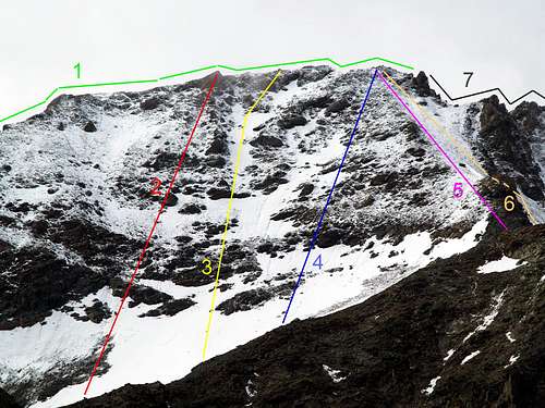
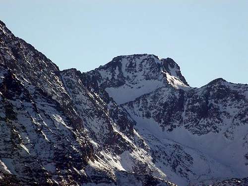
![P. di Leppe North Slope and Crests]()
- N-W Slope (Directly in right of N-NW Edge to Lussert Collar): Giovanni Bobba and Eliseo Jeantet, (Aug 02th, 1893), in descent between the West Summit and Western Antesummit to Collar and in North on Leppe Glacier, after the first absolute ascent. * First Replay: Agostino Ferrari and B. Glarey, (Sep 15th, 1898), in descent with same route. ** Second Repetition: Osvaldo Cardellina, Marco Cossard and Giuseppe Lamazzi, (Jun 29th, 1973), same via with descent to Collar, Summit of Lussert.
- N-NW Edge (Rocky-snowy Rib between North and Northwest Faces): Arnaldo Bertucci and Giovanni Battista Bozzino, (Aug 18th, 1910), in ascent from Gimillan.
- N Slope (Directly to West Summit, in left of N-NW Edge, by S Couloir Lussert Collar): Osvaldo Cardellina, lone, (Jul 12th, 1988), in descent to Leppe small Valley.
- N Slope (Directly to Central Summit, more to left of previous): Osvaldo Cardellina, lone, (Sep 13th, 1998), in descent from Summit.
- N Slope (Directly to East Summit, in extreme left): Osvaldo Cardellina, lone, (Sep 13th, 1998), in ascent from Les Laures.
- N-E Arête (to Leppe Hill): Agostino Ferrari and B. Glarey, (Sep 15th, 1898), in descent to Grande Roise complete traverse.
- E Face (directly to E Antesummit): Osvaldo Cardellina and Giuseppe Lamazzi, (Sep 13th, 1992), in ascent from Gr. Chaux.
Getting There
BY CAR:- From Torino, Milano, etc: Motorway A5. Exit in Aosta Ovest. Drive to the near Aymavilles. Follow in the direction of Valle di Cogne. Exit Aosta est For Grand Brissogne and Saint Marcel.
- From Switzerland: through the Grand St. Bernard Tunnel or the homonym Pass). Drive to Aosta, then follow Courmayeur direction on SS.26. Just after Sarre, turn to the left, in the direction of Valle di Cogne. For Grand Brissogne and Saint Marcel, turn to the right.
- From France: through Mont Blanc Tunnel or Petit St. Bernard Pass). It isn't necessary to enter in Motorway A5, you can drive through SS.26 Aosta direction. Before arriving at the Village of Sarre, follow the sign and turn right towards Valle di Cogne. After Aymavilles, the SR.47 crosses the Villages of Vieyes, Epinel and Cretaz and after about 25 Km. arrives at Cogne (1.534m). Follow the road signs for Gimillan and Lillaz; arrived at a round-about, recently built in proximity of the St. Anthony Chapel, go left along the scenic route leading to the Village of Gimillan (1.787m), 3 Km. after Cogne. Usually no parking problem. Exit Aosta est For Grand Brissogne and Saint Marcel.
BY PLANE:
![Punta di Leppe]()
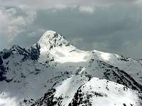
![Mont Avic from Leppe Peak]()
- Aeroporto "Corrado Gex" Saint Christophe (Aosta).
Routes with various respective Approaches
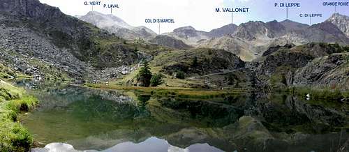
From Gimillan (1.787m), along the S-SE Arête: go right starting from the car park of Gimillan: after few meters the indications by panels for Lussert Lakes and St. Marcel Pass. Are found. The pathway is indicated by the yellow circle 9A and by yellow strips marked on stones along the route. The path begins going immediately uphill on the private farms dirt road just after the wooden bridge above Gimillan Torrent (signal no transit with iron hurdle), then, after leaving right the pasture and the little Church of Tarabouc (closed and deconsecrated), the slope decreases as we go beyond a little Chapel dedicated to the Virgin (1.836m), immediately after the ruins of Raventì Alp. Soon the path resumes to go up and splits in two branches, before it begins to penetrate into the Grauson Vallon: it's possible to continue following the right one that goes down as far as the Ecloseur Bridge (1.904m), nearby Tzecheu Alp. But in such a case we must go up again; it's better to follow the left one that, in practice without losing height, arrives at the bridge under the Alp Pila (2.025m), cross it and, following the stepped pathway, overcome the rocky bastion beside a fine waterfall (at the left). At this point the path turns right markedly, entering, high on the torrent, into a small walloon; by an alternation of steep and slight slopes, it reaches a panoramic cross, on the edge of a pleasant plateau (superb view of the far La Grivola!). The path goes through the meadows, with slight descent: after the Old Grauson Pastures (2.271m), crosses the two Torrents Money Grauson on the Pikaciù Bridge and by a steep trail beside the torrent, reach the wide upper part of the Grauson Vallon. At the junction before Pralognan Alp (about 2.400m), instead of going straight ahead along the pathway n° 4 leading to the head of Grauson/Doreire Walloon, go left till to New Grauson Alpage (2.540m), where once there was the burned Tentori Bivouac. Turning Eastward, pass over a small torrent coming down from the small Lago delle Rane (Frog's Loch aka known as Lower Corona 2.641m) and, on the above promontory, remount to the Lago Corona (2.702m); a little before it turn o Northeast on the path of Saint Marcel Hill also Coronas till you easy get it (2.916m). Now, toward North, flanking some characteristic rocks get the easy Mont Vallonet (3.101m) and, after descending to the following small saddle or Vallonet Pass, go on along the easy South-southeast Crest, at the beginning along steep terraces with grassy then slightly under the edge till the Summit finding on the edge passages of I° e II° with poor rock quality. (EE/F; 0h'30/0h'45 from the small Vallonet Pass; 1h'15/1h'30 from Saint Marcel Hill; 2h'30/3h'15 from Alp Grauson Nuove; 5h'30/6h'00 by Gimillan Hamlet).
Southern Approach from Gimillan Hamlet, through Grauson Vallon
 |
 |
 |
 |
 |
Da Gimillan (1.787 m), tramite la Cresta Sud-sudest: partendo dal parcheggio di Gimillan volgere a destra (Est-nordest) riscontrando subito dopo le indicazioni su pannelli per i Laghi del Lussert ed il Colle di Saint Marcel. Il percorso è indicato con cerchio 9A giallo, nonché da strisce gialle segnate sulle pietre lungo il percorso. Lo stesso inizia con una ripida rampa in salita sulla strada poderale dopo il ponte in legno sopra il Torrent de Gimillan (divieto di passaggio per i mezzi con sbarra in ferro), poi la pendenza diminuisce e tramite un sentiero da poco tempo ristrutturato si raggiunge, dopo aver lasciato a destra l'Alpe e Chiesetta di Tarabouc (chiusa e sconsacrata), una cappelletta dedicata alla Vergine (1.836 m), subito dopo l'Alpe in rovina del Raventì. Ben presto il sentiero riprende a salire dividendosi in due rami appena prima che incominci a penetrare nel Wallone del Grauson: è possibile continuare a seguire quello di destra che scende fino al ponte Ecloseur (1.904 m) presso l'Alpe Tzecheu. Ma in questo caso successivamente si deve risalire con una traversata in mezzo ai prati; forse è meglio seguire quello di sinistra che, in pratica, senza perdere di dislivello, arriva al ponte sotto l'Alpeggio Pila (2.025 m); lo si attraversa raggiungendo l'alpe e, seguendo il percorso su gradini artificiali, si supera la soprastante bastionata rocciosa accanto ad una bella cascata (a sinistra o Ovest). A questo punto il sentiero ripiega a destra marcatamente, entrando, alto sul Torrente Lussert, in un angusto valloncello; con alternanza tra pendii ripidi e più dolci, raggiunge una croce panoramica, ai margini d'un piacevole altopiano (superba vista in lontananza sulla Grivola!). Il sentiero attraversa i prati, leggermente in discesa raggiungendo una passerella adducente all'Alpe di Grauson Vecchie (2.271m); poi continua verso Est attraversando i Torrenti di Money e di Grauson sul Ponte Pikaciù. Costeggiando questo ultimo, il sentiero che sale con maggior pendenza accanto al torrente, raggiunge l'ampia parte alta della Vallone del Grauson. Al bivio prima dell'Alpeggio di Pralognan (circa 2.400 m), invece di proseguire lungo il sentiero n° 4 che porta alla testa del Vallone di Grauson/Doreire, andare a sinistra sin all'Alpeggio di Grauson Nuove (2.540 m), ove una volta esisteva il Bivacco Tentori, andato in seguito a fuoco. Da questi (oppure anche appena prima), voltando verso Est, passare sopra un torrentello discendente dal piccolo Lago delle Rane (a volte impropriamente anche chiamato Corona Inferiore 2.641 m) e, tramite il promontorio soprastante, rimontare al Lago Corona (2.702 m); appena prima del medesimo continuare verso Nordest sulla via del Colle di Saint Marcel o Coronas fino raggiungerlo facilmente (2.916 m). Ora, indirizzandosi verso Nord, fiancheggiando alcune roccioni caratteristici pervenire facilmente al Mont Vallonet (3.101 m) e, dopo averlo scavalcato tramite una breve discesa pervenire alla successiva selletta o Col Vallonet; proseguire lungo la facile cresta Sud-sudest, all'inizio, lungo ripide terrazze erbose quindi leggermente sotto il bordo dello spartiacque fino alla vertice trovando sul filo passaggi di I° e II° con scarsa qualità della roccia (EE/F; 0h'30/0h'45 dal Col Vallonet; 1h'15/1h'30 dal Colle di Saint Marcel; 2h'30/3h'15 dall'Alpe Grauson Nuove; 5h'30/6h'00 da Gimillan).
From the Summit Southwards & Northwards
 |
 |
 |
 |
 |
From Saint Marcel, always along the S-SE Arête: from Les Druges Alta, locality Pouria (1.600m); various panels) starting from the small lay-by beyond the dump of the above abandoned copper mine Chuc-Servette, and after rounding the cape entering the real walloon, walk "suspended" on the left (East) along the whole Valley of Saint Marcel and, after passing a small gate, border of the Reserve by Marquis Turati ex Baron Peckoz, and after a short descent, remount passing through Mulac Hunting House (1.937m), boarding on the right the manganese old Mine of Praz Bornaz also Praborna (abandoned for years now).Cross the torrent on a bridge (1.995m) and walk up (little steeper) get two Plan Ruè Pastures (2.100m) and, immediately after, to those of Plan d'Emonin (2.205m). Once in Layet (2.233m) (fine small lake) in a few time you get the hunting House "Turati", (once Casa Barone Peckoz) (2.370m). From Grand Chaux, leave on the Western side the route of the small walloon or Petit Vallon for the Leppe Pass and
1) - more to West-southwest the one of the big vallon also Grand Vallon (leading to the Vallonet Pass (3.062m) along tracks, more straight but steep and tiring).Once at the fork (2.602m; in opposite the other path goes to Lavodilec Hill 2.863m). Besides
2) - move more and more to the right, first with a Southerly direction and then the Southwest, crossing along a diagonal ascent on the morainic slopes of hanging Vallon Fenêtre you get the Saint Marcel also Corona Hill ((2.916m; abundant presence of soapstone). From here follow the route coming from Gimillan, or shorten the route with the previous itinerary via Vallonet Pass certainly more direct but also more laborious and less scenic (EE/F; 0h'30/0h'45 from the small Vallonet Pass; 1h'15/1h'30 from Saint Marcel Hill; 3h'00/3h'30 from Grande Chaux Hunting House; 6h'30/7h'00 by Tall Les Druges Village).
Da Saint Marcel, sempre lungo la Cresta Sud-sudest: da Les Druges Alte, località Pouria (1.600 m; cartelli varii), a partire dalla piccola piazzola al di là della discarica dell'abbandonata miniera di rame Chuc-Servette, e dopo aver doppiato il promontorio entrando nel vero e proprio vallone, camminare "sospesi" sulla sinistra (Est) lungo l'intera Valle di Saint Marcel e, dopo aver superato un cancelletto, confine della Riserva di proprietà del Marchese Turati ex Barone Peckoz, e dopo una breve discesa, rimontare passando la Casa di Caccia di Mulac (1.937 m), con immediatamente sulla destra l'antica miniera di manganese (abbandonata ormai da molti anni) di Praz Bornaz o Praborna. Si attraversa il torrente su d'una passerella (1.995 m) e tramite percorso appena più ripido arrivare alle due Alpi di Plan Rué (2.100 m) ed immediatamente dopo a quelle del Plan d'Emonin (2.205 m). Dopodiché raggiungerre l'Alpe di Layet (2.233 m; grazioso laghetto) ed in breve tempo pervenire alla Casa di Caccia "Turati", (una volta Casa Barone Peckoz; 2.370 m). Da Grand Chaux, lasciare ad Occidente la via adducente al valloncello per il Colle di Leppe o Petit Vallon ed invece
1) - prendere più a Ovest-sudovest quella della Grand Vallon che conduce al Colle di Vallonet (3.062 m) tramite un sentierucolo seguito da tracce con percorso più diretto ma ripido e faticoso ad Ovest partendo dal bivio sottostante (2.602 metri; in direzione opposta l'altro s'indirizza al Colle di Lavodilec). Altrimenti
2) - dirigendosi invece ancora maggiormente sulla destra , dapprima con direzione Sud e quindi Sudovest, attraverso un lungo diagonale tra pendii morenici nel cosiddetto e superiore Vallon Fenêtre, si perviene al Colle di Saint Marcel o Coronas (2.916 m; pietra "ollare"). Da qui riprendere il percorso da Gimillan, oppur abbreviarlo col precedente itinerario tramite il Col Vallonet sicuramente più diretto ma pur più faticoso e noioso nonché meno panoramico (EE/F; 0h'30/0h'45 dal Col Vallonet; 1h'15/1h'30 dal Colle di Saint Marcel; 3h'00/3h'30 dalla Casa di Caccia Grande Chaux; 6h'30/7h'00 da Les Druges).
From Grand Brissogne Municipality and through the Laures Valley, along the NE Arête: Starting from Grand Brissogne (894m), go along the dirt road, closed to traffic, till the Gremonenche Pasture (1.000m). From here always along the private farms road up to l'Arp (1.310m) then, along a path that, bordering the stream (Des Laures), leads to La Vieille (1.623m) and to Le Tramail or highest and last Alp (1.951m; good shelter when weather is bad). Crossing some small stone bridges and wooden footbridges up to the altitude of around 2.200 meters, (starting from this point a steep but faster path goes, at right or Southwest, toward the Northeastern slopes of Becca di Seneva). Better go on toward East-southeast forwarding the Northwestern Walls of Becca di Salè (zone called of the Black Fountains) and climb the last 400 meters on wide slopes till the top of the hanging rocky terraces (2.600m. Here was built in 1930 a small chapel dedicated to brothers mountaineers Alessandro "Dino" and Jean Charrey with Cino Norat dead in August 1929 on the East Wall of Monte Emilius). A short descent to the left leads to the Refuge Ernesto Menabreaz (2.542m; private. The refuge has an open free part with covers usable as winter room with 8 places), on the Eastern bank of Lower Lake of the Laures. From here toward South getting, after a short step, the Alpage and Lago Lungo di Laures (2.630m), walk all along the Western bank on the path that fastly becomes a track turning toward the lower part of the big Southwest Ridge of Grande Roise (3.357m), the highest peak of this vast area. First to South, toward the more Western slopes of Quota 3.189 meters and of Punta di Lussert 3.221m), then to East along snowfields, bordering on the right with the remains of the ancient and extinct Glacier Laures and the next Leppe now reduced to a miserable reality, you can get easily, through a final slope less steep, to the Leppe Hill (3.110m). Along the easy Northeast Crest (careful with fresh snow or ice, because the slightest trace disappears going to "merge" with the rock) on debris or by simple and small rocks with some bypass to the right (almost always to the West) and easy scramble up the secondary Eastern Summit (about 3.292/3 meters), after overtaking even the Central slightly lower (about 3.300 meters), then and finally to the Western Summit (3.305/6m). Wanting, and in short, after a saddle debris, you tap, with the little and easy climbing from the South, Western Antesummit (about 3.290m) consists of a distinctive rock-shaped tower on West Ridge, that, after a second and wider saddle, precipitates abrupt and jagged on below and overhanging Lussert Collar (EE/A; F+; 2h'15/2h'45 from shelter; 0h'30/0h'45 from hill; 6h'00/7h'00 by Brissogne).
Southern Standard Route, with Western Top and West Antesummit & Eastern Summit
 |
 |
 |
 |
 |
Dal Comune di Grand Brissogne ed il Vallone delle Laures, tramite la cresta Nordest: partendo da Grand Brissogne (894 m), percorrere la strada sterrata, con divieto di transito, fino all'Alpe di Gremonenche (1.000 m). Da qui lungo la poderale privata fino a l'Arp (1.310 m) poi, lungo un percorso che, confinante con il Torrente des Laures, porta a La Vieille (1.623 m) e Le Tramail (1.951m; o ultimo e più elevato alpeggio costituente buon riparo in caso di tempo brutto). Attraversando alcuni ponticelli e passerelle in legno salire fino alla quota di circa 2.200 metri (a partire da questo punto un sentierino ripido ma più veloce risale verso destra o Sudovest, verso le pendici Nordorientali della Becca di Seneva). Meglio proseguire verso Est-sudest in direzione delle pareti Nordovest della Becca di Salè (località detta delle Fontane Nere) e risalire gli ultimi 400 metri su ampi pendii fino alla cima dei soprastanti terrazzamenti rocciosi (2.600 metri all'incirca. Quivi é stata costruita nel '30 una piccola cappella dedicata ai fratelli Alessandro "Dino" e Jean Charrey con Cino Norat morti nell'Agosto del 1929 sulla Parete Est del Monte Emilius). Una comoda discesina in diagonale a sinistra porta al Rifugio Ernesto Menabreaz (2.542 m; privato ma sempre aperto. Il rifugio possiede una parte libera aperta utilizzabile come sala d'inverno con 8 posti letto, sulla sponda Orientale del Lago Inferiore delle Laures. Da qui verso Mezzogiorno raggiungere con breve percorso l'Alpe ed il Lago Lungo di Laures (2.630 m), lungo la sua sponda Occidentale sul sentiero che s'indirizza verso la parte inferiore della grande Cresta Sudovest della Grande Roise (3.357 m), la vetta più elevata di questa vasta area. Dapprima a Sud, verso le propaggini più Occidentali della Punta di Lussert 3.221 m), poi ad Est lungo noiose morene e facili nevai confinanti sulla destra coi resti dell'antico ed estinto Ghiacciaio delle Laures e del successivo di Leppe ormai ridotto a misera realtà, si perviene, tramite un ultimo declivio più dolce, facilmente al Colle di Leppe (3.110 m). Lungo la facile Cresta Nordest (attenzione in presenza di neve fresca o ancor peggio di ghiaccio) su detriti e semplici roccette con qualche aggiramento a destra (Ovest) si raggiunge quindi il vertice Orientale e, dopo aver scavalcato la Centrale veramente di poco più bassa (3.300 metri circa), subito dopo la più alta Punta Occidentale (3.305/6 m). Volendo ed in breve, dopo una sella detritica, si tocca con breve nonché facile arrampicata da Sud l'Antecima Ovest (3.290 m circa)costituita da un caratteristico roccione a forma di torretta sulla Cresta Ovest, che a sua volta, dopo una seconda e ben più larga sella, precipita abrubta e frastagliata sul sottostante nonché sospeso Colletto di Lussert (EE/A; F+; 2h'15/2h'45 dal rigugio; 0h'30/0h'45 dal colle; 6h'00/7h'00 da Brissogne).
![La Punta di Leppe]() Equipaggiamento ed attrezzatura adatti per trekking di alta montagna.
Equipaggiamento ed attrezzatura adatti per trekking di alta montagna.
![Il versante Nord della punta...]()
Equipment
Gear suitable for high mountain hiking.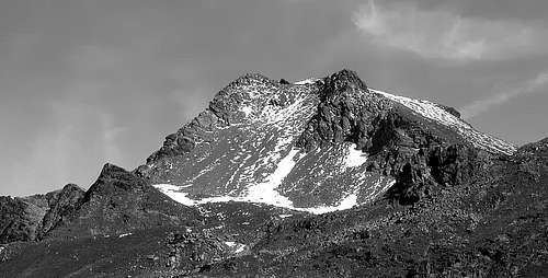
Difficulties
Normal Route through South-southeast Crest from Vallonet or Saint Marcel Passes: EE/F.+ Northeast Ridge from Leppe Pass: EE/A/F+.
Via Normale dalla Cresta Sud-sudest dai Colli Vallonet o di Saint Marcel: EE/F. Cresta Nordest dal Col di Leppe: EE/A/F+.
Huts
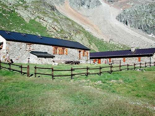
- Rifugio E. Menabreaz
 |
Campings
Remember that free camping is forbidden (except for emergency reasons, over 2.500m, from darkness until dawn).Mountain Condition
- Meteo: you can find all the needed informations at the official site of the Valle d'Aosta Region:
- Valle d'Aosta Meteo
Webcam
- WEBCAM on Aosta Valley:
- Webcam
Books and Maps
BOOKS:- "Guida delle Alpi Occidentali", di Giovanni Bobba e Luigi Vaccarone C.A.I. Sezione di Torino Volume II (parte II), 25 Maggio 1896.
- "80 itinerari di Escursionismo Alpinismo e Sci Alpinismo in Valle d'Aosta", di Osvaldo Cardellina, Ed. Musumeci, Giugno 1977 (in Italian); seconda Ed. Luglio 1981; terza Ed. Luglio 1984; (in French), prima Ed. Febbraio 1978; seconda Ed. Marzo 1980.
- "Guida del Monte Emilius", di Osvaldo Cardellina Editore in collaborazione con il Club Alpino Italiano Sezione di Aosta, Dicembre 1978 (in Italian).
- "Rifugi e bivacchi in Valle d'Aosta di Cosimo Zappelli", aggiornata da Pietro Giglio, Musumeci Editore, Luglio 2002.
- "Guida dei Monti d'Italia–Emilius Rosa dei Banchi Parco del Mont Avic", di Giulio Berutto e Lino Fornelli - Club Alpino Italiano/Touring Club Italiano, Marzo 2005 (in Italian).
- "Il Parco Nazionale del Gran Paradiso", G. Berruto III°, volume 2° Ed. I.G.C. Torino 1981, 2000.
- "Diari Alpinistici" di Osvaldo Cardellina e Indice Generale accompagnato da Schedario Relazioni Ascensioni 1964-2019 (unpublished).
 |
 |
 |
 |
 |
 |
 |
MAPS:
- Kompass "Gran Paradiso Valle d'Aosta Sentieri e Rifugi" Carta Turistica 1:50.000.
- Hapax Luglio 2000 "Les Sentiers" Comunità Montana Monte Emilius 1:25.000.
- Enrico Editore Ivrea-Aosta "Gruppo del Gran Paradiso" 1:50.000.
- I.G.C. Istituto Geografico Centrale Torino "Carta delle Passeggiate ed Escursioni in V.D.A. Conca di Pila-Gressan" 1:20.000.
- L'Escursionista Ed. "La Valle di Cogne" 1:25.000.
- L'Escursionista Ed. "Tour de la Vallée de Cogne Grand Paradis" Carta dei sentieri 1:25.000.
Starting Point - Accomodation
Rifugio Ernesto Menabreaz (2.542m, privat), the refuge has an open free part (with covers) usable as winter room (8 places).
Important Information
- REGIONE AUTONOMA VALLE D'AOSTA the official site.
- FONDAZIONE MONTAGNA SICURA Villa Cameron, località Villard de la Palud n° 1 Courmayeur (AO) Tel: 39 0165 897602 - Fax: 39 0165 897647.
- SOCIETA' GUIDE ALPINE DI COGNE Tel. 347/9473526 – 328/1373728.
- A.I.NE.VA. (Associazione Interregionale Neve e Valanghe).
- A.IA.T. Cogne Gran Paradis via Bourgeois n° 34 Tel. 0165-74040. E-mail: aiat@cogne.org
- Ezio Sport articoli sportivi - via Bourgeois n° 64 Tel. 0165-74204.
Useful numbers
- Soccorso Alpino Cogne (SAR) Tel. 3482685406.
- Protezione Civile Valdostana località Aeroporto n° 7/A Saint Christophe (Ao) Tel. 0165-238222.
- Bollettino Meteo (weather info) Tel. 0165-44113.
- Unità Operativa di Soccorso Sanitario Tel. 118.
Acknowledgements
I am greatly indebted to my friend "Osva" for his fundamental support, texts and translation.